


What you need to know
— What: A weak low-level trough is forecast to move across the Lesser Antilles tonight (Saturday night), with a surge in moisture and trailing, strong surface to low-level winds, producing intermittent showers and gusty winds. A strong high-pressure system will build following the trough and remain dominant through the week.
— Where: Peak winds are forecast north of T&T, but stronger winds are likely across Tobago, northern and eastern Trinidad, and in the vicinity of rainfall. Over the next five days, overall rainfall accumulations are forecast to remain below 15 millimeters across most of Trinidad and Tobago. In localized areas, between 15 and 25 millimeters are forecast, falling mainly between Sunday and Monday. Across the southwestern, southern, and eastern areas, locally higher totals are possible.
— When: Peak winds and rainfall are forecast on Sunday and Monday. Elevated Saharan Dust is forecast through the next five days.
— Impacts: The main hazards, primarily through Monday, will be gusty winds. Peak gusts to 55 km/h likely, and higher gusts possible, leading to fallen trees/utility poles/lines, as well as localized wind damage and agitated seas. There is a low chance of street flooding, particularly on Sunday afternoon through Monday morning, favoring southern Trinidad.
— What Should You Do: Be aware of your surroundings and changing weather conditions. Secure loose outdoor objects, particularly on Sunday and Monday. All sensitive groups should take all necessary precautions due to the expected decrease in air quality from Sunday.
Latest Alerts

Localized Flood Alert Discontinued For Trinidad
Trinidad and Tobago is NOT under any tropical storm or hurricane threat, watch, or warning at this time.
The Forecast
Sunday
SundayMonday
MondayTuesday
TuesdayWednesday
WednesdayThursday
ThursdayMarine Forecast

Seas Forecast: Long-Period Swells To Return Next Week
Temperatures
Sunday
Low: 23-24°C
High: 29-31°C
Feels Like: 33-35°C
Monday
Low: 23-24°C
High: 30-32°C
Feels Like: 33-35°C
Tuesday
Low: 23-24°C
High: 30-32°C
Feels Like: 33-35°C
Wednesday
Low: 23-24°C
High: 30-32°C
Feels Like: 33-35°C
Thursday
Low: 22-24°C
High: 30-32°C
Feels Like: 33-35°C
Forecast Impacts
Flooding
Over the next five days, overall rainfall accumulations are forecast to remain below 15 millimeters across most of Trinidad and Tobago. In localized areas favoring eastern and southwestern Trinidad and eastern Tobago, between 15 and 25 millimeters are forecast, falling mainly between Sunday and Monday. Across the southwestern, southern, and eastern areas, locally higher totals are possible.
Street & Flash Flooding
Street & Flash FloodingRiverine Flooding
Riverine FloodingForecast Rainfall Totals
- Sunday: Across both islands, up to 15 millimeters of rainfall accumulation forecast, with locally higher totals possible in northern and southwestern areas.
- Monday: Across both islands, up to 10 millimeters of rainfall accumulation forecast, with locally higher totals possible across Trinidad, favoring southern and eastern areas.
- Tuesday: Little to no rainfall forecast with isolated totals up to 5 millimeters across northeastern areas of both islands.
- Wednesday: Little to no rainfall forecast with isolated totals up to 5 millimeters across northeastern areas of both islands.
- Thursday: Little to no accumulating rainfall forecast with isolated totals up to 10 millimeters across eastern areas of both islands.

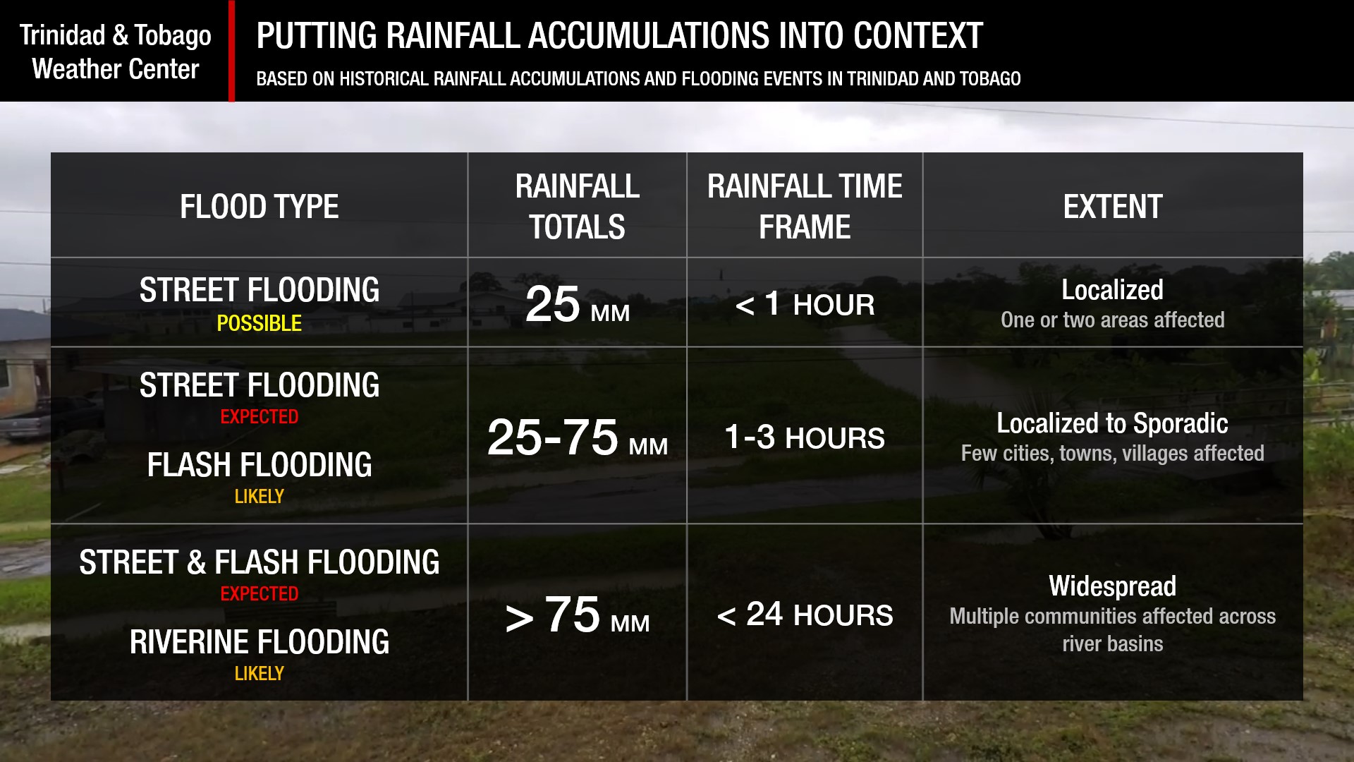
Understanding Rainfall Accumulations
Putting the rainfall forecast into context, rainfall rates exceeding 50 millimeters per hour, or areas receiving more than 25 millimeters in an hour, tend to trigger street flooding across the country or flash flooding in northern Trinidad. For riverine flooding to occur, a large area of the country (not just in highly localized areas of western coastal Trinidad) would have to record upwards of 75 millimeters within 24 hours, and rainfall would have to fall across the catchment areas of major rivers.
Strong Thunderstorms
Strong ThunderstormsWhat is a strong or severe thunderstorm?
Given how rare these types of thunderstorms are in our region – we classify a severe or strong thunderstorm as one that produces any of the following:
- Damaging wind gusts exceeding 63 KM/H;
- Frequent lightning (more than 30 cloud-to-ground strikes within a 10-minute period);
- Hail (of any size);
- Rainfall of more than 50 millimeters or more within an hour or exceeding 75 millimeters or more within three hours;
- The sighting of a funnel cloud or touchdown of a waterspout/tornado associated with the thunderstorm.
Gusty Winds
Gusty WindsWith wind gusts reaching and possibly exceeding 55 km/h, whole trees can be in motion, with larger trees and weaker branches falling. Light outdoor objects can topple or become airborne, such as garbage cans, loose galvanize, construction material, and outdoor furniture. Tents may also jump.
Other Hazards
Moderate-to-high-concentration surges of Saharan Dust are forecast to move across T&T starting Sunday. Seas are also forecast to become hazardous.
Saharan Dust Forecast

Next Saharan Dust Surge Forecast By Mid-Next Week
Why I May Not/Will Not See Rainfall?
A frequent complaint is that the forecast is wrong because I didn’t experience any rainfall. Scattered showers mean that you, individually, may experience some showers intermittently throughout the day, and there is a higher chance for this activity than for isolated activity. Widespread showers mean that nearly everyone and every area can expect rainfall.
Isolated rainfall is forecast over the next five days.

Forecast Discussion
March is Trinidad and Tobago’s driest month, and March 2026 is living up to its climatology. However, a weak low-level trough is forecast to move across the area on Saturday night, bringing needed rainfall to the Lesser Antilles, including T&T, on Sunday into Monday. Favorable low-level convergence and elevated moisture at the lowest levels of the atmosphere trailing this trough are also forecast to produce cloudy skies with brisk showers.
The atmosphere isn’t conducive to long-lasting rainfall or deep convection. The mid- and upper-level environment remains dry, wind shear remains strong from the west (meaning stronger shower activity will remain offshore east of T&T and higher rainfall accumulations will favor eastern areas), and, with Saharan Dust surging on Monday, there will not be much moisture after midday.
However, the main weather story over the next 48 hours will be the wind. A building surface to a low-level high-pressure system is forecast to move in following the low-level trough’s exit into the Caribbean Sea on Saturday night into Sunday morning. Surface to low-level winds are set to increase across the region, mainly north of T&T, where gusts are likely to range between 55 km/h and 75 km/h.
For Trinidad and Tobago, elevated wind speeds and gusts are forecast on Sunday through Tuesday, peaking on Monday afternoon. Between Sunday afternoon and Monday evening, sustained winds are likely to peak at 45 km/h with likely peak gusts at 55 km/h. Stronger gusts, between 55 km/h and 75 km/h, are possible on Monday afternoon, favoring northern and eastern areas of both islands, mainly associated with shower activity.
As of Saturday evening, forecast models give a 20-30% chance of gusts exceeding 65 km/h on Monday between 11 AM and 5 PM. These gusts can be damaging and lift loose outdoor objects into the air. Now is the time to secure these items ahead of strong winds. These winds may require the issuance of a High Wind Alert from the Trinidad and Tobago Meteorological Service, which is issued when there is the risk of impactful gusts exceeding 55 km/h. There is already a Hazardous Seas Alert in effect from 6:00 PM Sunday.
Winds begin to subside by Tuesday afternoon, with mostly dry and breezy conditions into the remainder of the week. On Wednesday, a marginal increase in moisture will lead to brief passing showers continuing into Thursday.


