


Flooding in Trinidad and Tobago has become this country’s most frequent natural disaster. Flooding happens when water inflow into an area is faster than the outflow. Although floods may be categorized differently, one category may merge into another.
Pluvial or Surface Flooding
Undoubtedly, street flooding, also known as urban or pluvial flooding, is the most common type of flooding in Trinidad and Tobago. Pluvial flooding is the umbrella term covering all surface flooding, meaning heavy rainfall creates a flooding event independent of an overflowing water body such as a drain, stream, or river.
Street/Urban Flooding
Street Flooding along the Eastern Main Road, St. Augustine on November 6th 2018 due to 30 minutes of heavy rainfall and blocked drainage.
Urban/Street flooding, a type of pluvial flooding, is more common in urbanized areas of Trinidad and Tobago, where heavy rainfall overwhelms the drainage system, and water flows into streets and occasionally into structures. This is frequently seen along the East-West Corridor, along the nation’s highways where inadequate drainage exists, and most notoriously, Port of Spain. In Tobago, it favors Bon Accord and Scarborough.
Urban and street flooding can be mitigated, but it requires corporation from both government and individual citizens. Proper drainage needs to be present for water to run off in relatively urbanized areas. However, even in places with sufficient drainage, littering and illegal dumping are pervasive problems across the islands. Litter block drains during rainfall, and these blockages are sometimes directly responsible for street/urban flooding in uncharacteristic locations.
Traditional Pluvial Flooding
The other type of pluvial flooding occurs in rural areas or hillsides, where rainfall exceeds the rate soils absorb the rain, causing water to pool (on a flat surface) or runoff (where topography exists). Hillsides with recent forest fires are notorious sources of pluvial floods, as are suburban communities on hillsides.
Unfortunately, traditional pluvial floods are much harder to avoid, mainly in tropical areas where heavy downpours are the norm. However, by reducing the amount of clearing that occurs on soil and allowing vegetation to exist, soils can retain significantly more water and prevent extreme runoff or ponding from occurring.
During the dry season, the slash-and-burn method of clearing agricultural land is widespread in Trinidad and Tobago. This method, year after year, triggers several bush/wildfires nationwide, reducing the soil’s absorption. Decreasing the slashing and burning method to clear land gives us a better chance to combat pluvial flooding.
Fluvial (River) Flooding
Fluvial flooding occurs when excessive rainfall, either over a short or long period, causes a watercourse to exceed its capacity. This type of flooding in Trinidad and Tobago is usually the most damaging, as it encompasses both flash and riverine flooding.
Flash Flooding
Flash flooding, a type of fluvial flooding, is the next most frequent type of flooding experienced in Trinidad and Tobago. Flash flooding is characterized by an intense, high-velocity torrent of water that occurs in an existing river channel with little to no notice. Flash floods are hazardous and destructive not only because of the force of the water but also the hurtling debris that is often swept up in the flow.
Flash floods are difficult to predict in Trinidad and Tobago and usually occur within minutes to hours (usually less than 2 – 3 hours in T&T). Flash floods can be dangerous because of the sudden onset and the high traveling speed of the water. The water can transport large objects like rocks, trees, and cars. Never drive through a flash flood, even if it doesn’t seem very deep: the vehicle may be swept away by the sheer speed of the water.
Riverine Flooding
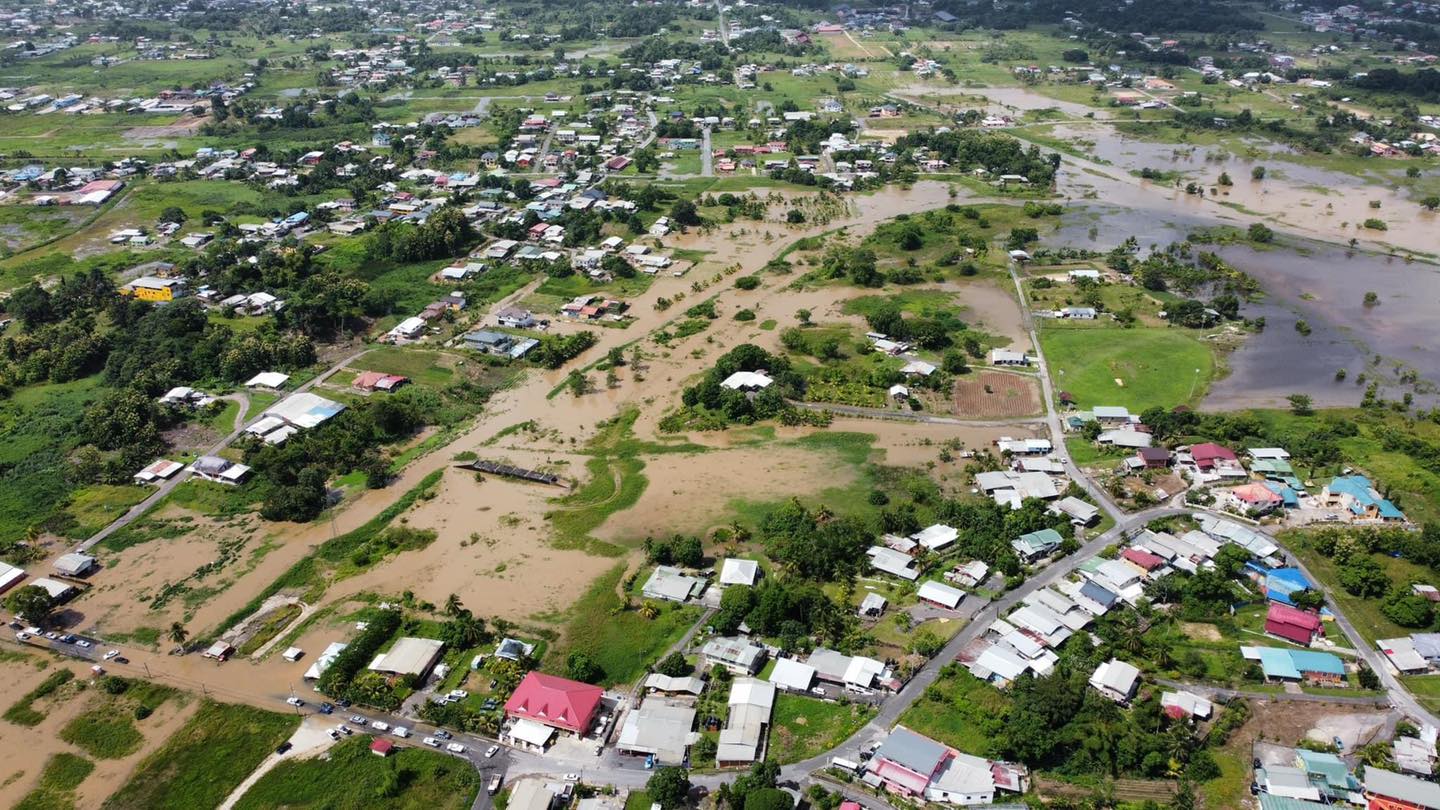
As the Caroni River overtopped its banks in a spectacular and unprecedented fashion, strong currents of water moved across both sides of the Uriah Butler Highway during the historic floods of October 17th-21st 2018
Riverine flooding, another type of fluvial flooding, occurs when water from a primary watercourse, or river, overtops its banks. The water can cover enormous areas. Rainfall over an extended period and a vast area can cause major rivers to overflow their banks. Downstream regions may be affected, even when they didn’t receive much rain.
The severity of riverine flooding is determined by the amount of precipitation in an area, how long rainfall accumulates rainfall, the previous saturation of local soils, and the terrain surrounding the river system.
In flatter areas, floodwater tends to rise more slowly and be more shallow and often remains for days. This is usually common in the Caroni River and South Oropuche River areas.
The process is relatively slow with large rivers like the Caroni River and the South Oropuche River. While rain may fall directly into the rivers, much of the rise of major rivers comes from their tributaries. Smaller streams and rivers usually are the first to overtop their banks, as the water flows towards the larger rivers. When there is excessive rain over an extended period, the rise in the major rivers usually takes 24-72 hours, as water from smaller rivers converges into the main watercourse. It takes time for all the rainwater to reach the river, but once it is in the river, it has to flow downstream to the sea.
While the water level slowly rises, officials can decide to evacuate people before the river overflows. The flooded area can be huge, as seen from the October 2018 floods across Central Trinidad.
On a governmental level, much can be done to mitigate riverine flooding. De-silting of major watercourses, clearing primary and secondary watercourses of shrubbery that hindered water flow, and increased leveeing along rivers in flood-prone areas, to name a few methods. However, due to improper infrastructural planning across the country, with several settlements built in the flood plains of rivers, riverine flooding is inevitable.
On an individual level, we see that illegal dumping is a significant issue. Proper disposal of waste, whether trash, old furniture, and appliances, to tree branches and shrubbery, is paramount to ensuring watercourses remain as free-flowing as possible during heavy rainfall. For areas located in flood-prone areas, sandbagging and preparation are vital to securing your personal property and evacuating before conditions deteriorate.
Coastal Flooding
Coastal flooding due to storm surge in Miami due to Hurricane Florence in September 2017.
As the name suggests, a coastal flood occurs in areas on the coast of a sea, ocean, or other large bodies of open water. It is typically the result of extreme tidal conditions caused by severe weather.
In Trinidad and Tobago, we usually see coastal flooding during a long period swell event, where large battering waves affect the coastlines, or during exceptionally high tide events known as Spring Tide and the rare King Tide events.
Coastal flooding also occurs associated with tropical cyclones and is dubbed storm surge. Storm surge is generated by high winds associated with a tropical cyclone pushing water onshore. Water overwhelms low-lying land near the coast and can cause devastating loss of life and property.
Coastal flooding can be categorized into three levels:
- Minor: A slight amount of beach erosion will occur but no major damage is expected.
- Moderate: A fair amount of beach erosion will occur as well as damage to some homes and businesses.
- Major: Serious threat to life and property. Large-scale beach erosion will occur, numerous roads will be flooded, and many structures will be damaged. Citizens should review safety precautions and prepare to evacuate if necessary.
The severity of a coastal flood is determined by several factors, including the storm’s strength, size, speed, and direction. The onshore and offshore topography also play an essential role.
Coastal flooding was regularly seen along the South Trunk Road, along Mosquito Creek during high tide events before the elevation of the roadway, and along the Manzanilla Mayaro Road in Trinidad. Long-period swells trigger battering waves, causing coastal flooding and beach erosion across many of Trinidad and Tobago’s coastlines.
Unfortunately, as the planet continues to warm and ice caps continue to melt, a rising sea level may cause devastating impacts to coastal communities in extreme events and become a nuisance during normal high tides.
Beyond creating sufficient artificial coastal defenses, such as higher sea walls, raising the road levels, and making artificial sand or rock dunes, there isn’t much we can do to prevent coastal flooding. Coastal mangroves protect inland areas, but in a similar situation to riverine flooding, much of the coastal settlements already exist where there is not much protection from mangroves. As seas continue to warm, expand, and rise due to melting ice caps, this problem will likely become more frequent and severe.
Groundwater Flooding
As opposed to flash floods, groundwater flooding takes time to occur. As rain falls over an extended period, the ground becomes saturated with water until it cannot absorb any more. When this happens, the water rises above the ground’s surface and causes flooding.
This is a fairly common problem in parts of Western Europe and the United Kingdom but was mainly unheard of in Trinidad and Tobago until recently. During the October 2018 floods, residents living near the Gandia River along Chin Chin Road reported that water rose from the ground instead of flowing into their homes from nearby drains at threshold levels.
Unfortunately, there isn’t much a homeowner can do to protect their property from this type of flooding. Mitigation and water management measures are typically recommended, such as contracting additional drainage on your property to aid runoff and investing in pumps to remove water from your home.
How much rain is needed to trigger flooding in T&T?

Putting rainfall forecasts into context, rainfall rates in excess of 50 millimeters per hour or areas that receive in excess of 25 millimeters within an hour tend to trigger street flooding across the country or flash flooding in northern Trinidad. For riverine flooding to occur, a large area of the country (not just in highly localized areas of western coastal Trinidad) would have to record upwards of 75 millimeters within 24 hours, and rainfall would have to fall across major rivers’ catchment areas.