


Key Messages:
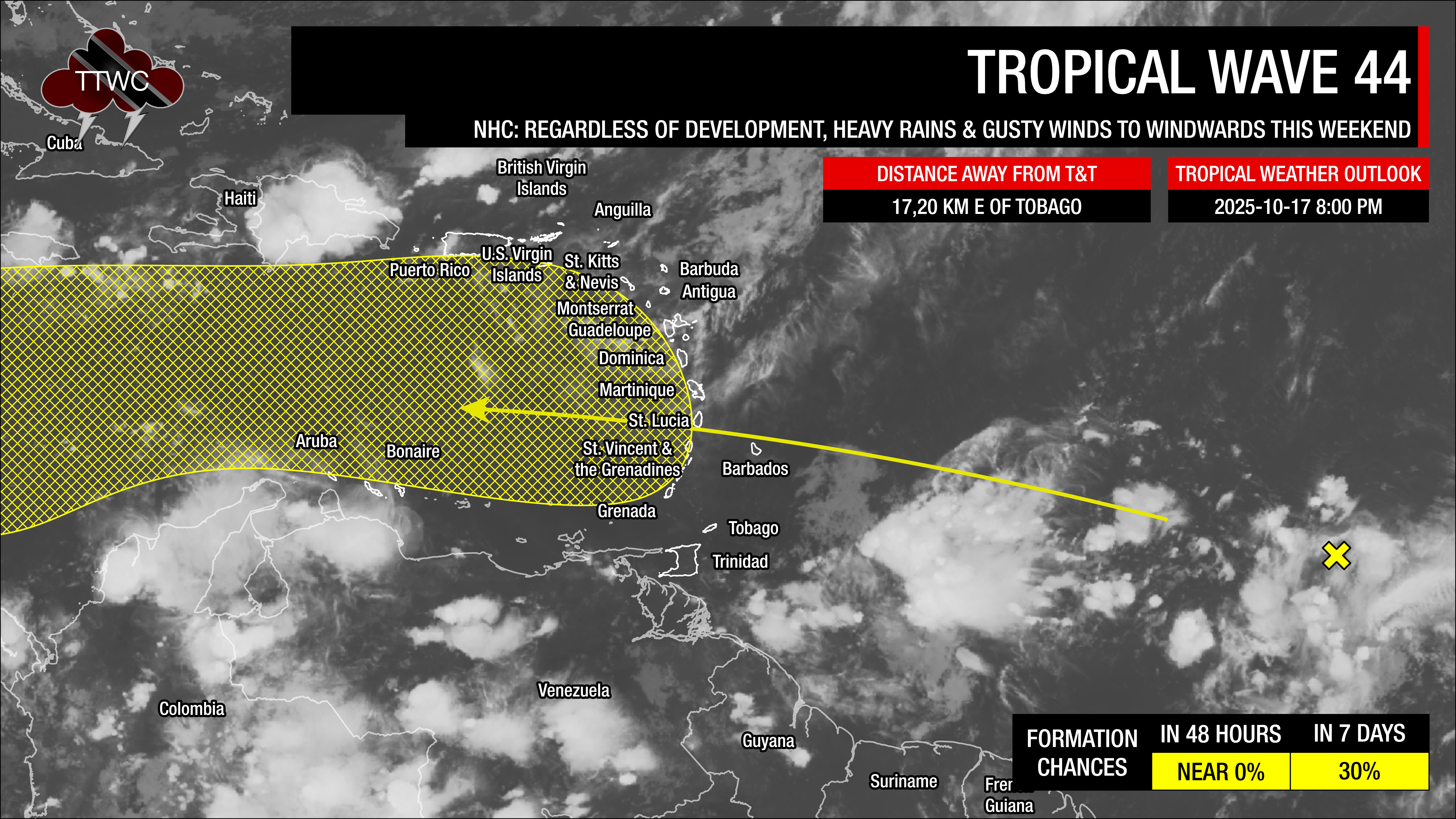
— Tropical Wave 44 is being monitored by the National Hurricane Center for development, with a near-zero percent chance of development over the next 48 hours as it moves into the Caribbean Sea by Monday.
— Regardless of development, this tropical wave, combined with the ITCZ and a favorable atmosphere, is likely to lead to heavy rainfall on Saturday, Sunday, and Monday (Divali) across parts of T&T, which is expected to lead to street/flash flooding, accompanied by gusty winds exceeding 50 km/h. From Sunday night, watercourses are likely to be elevated.
— Those living in low-lying and flood-prone areas should pay close attention to forecasts, early warning messages from the TTMS, and watercourses in their area. Ensure you have a plan in place to protect lives, livelihoods, and property in the event of flooding.
What you need to know
— What: Two tropical waves (TW43 and TW44), the Intertropical Convergence Zone, and a combination of favorable upper- and low-level conditions, deep-layered moisture, and light wind shear are forecast to lead to periods of rain, showers, and thunderstorms, some of which may be locally heavy/strong, particularly by Sunday into Monday. Swells are also forecast to create hazardous marine conditions through mid-next week.
— Where: Both islands are forecast to experience locally high rainfall with 4-day totals (Saturday through Tuesday). Latest forecasts show up to 75 millimeters across both islands, with localized totals up to 150 millimeters across parts of Trinidad. Gusty winds (50 km/h) are likely from Saturday, with higher gusts across Tobago and in heavy shower/thunderstorm activity across both islands. Swells are forecast to primarily affect northern and northeastern coastlines, and to a lesser extent, north-facing coastlines in the Gulf of Paria.
— When: Periods of rain, with showers and thunderstorms, some of which may be locally heavy/strong, are forecast to begin from pre-dawn on Saturday, and continue intermittently through Monday night. The TTMS has issued the Adverse Weather Alert from noon Saturday, October 18th, 2025, through 10:00 PM Monday, October 20th, 2025, capturing most of the intense activity.
— Impacts: Street/flash flooding and localized ponding are likely in heavy downpours, accompanied by gusty winds exceeding 50 km/h. These wind gusts, combined with heavy rainfall, may lead to fallen trees/utility poles/lines and landslides, as well as localized wind damage and agitated seas. In strong thunderstorm activity, frequent lightning is likely, with the possibility of funnel clouds on Sunday into Monday. By Sunday night, as soils become saturated, those living in flood-prone areas along larger watercourses should be aware of the possibility of flash or riverine flooding.
— What Should You Do: Secure loose outdoor objects. Motorists and residents in areas prone to flooding or landslides should remain alert and exercise caution. Be aware of your surroundings and changing weather conditions. Take necessary precautions to mitigate potential impacts. If you encounter flood waters, turn around. If you hear thunder, head indoors.
Latest Alerts

Localized Flood Alert Discontinued For Trinidad
Trinidad and Tobago is NOT under any tropical storm or hurricane threat, watch, or warning at this time.
The Forecast
Saturday
SaturdaySunday
SundayMonday (Divali)
Monday (Divali)Tuesday
TuesdayWednesday
WednesdayMarine Forecast

Seas Forecast: Long-Period Swells To Return Next Week
Temperatures
Saturday
Low: 24-25°C
High: 30-32°C
Feels Like: 35-38°C
Sunday
Low: 24-26°C
High: 28-30°C
Feels Like: 30-35°C
Monday
Low: 24-26°C
High: 28-30°C
Feels Like: 30-35°C
Tuesday
Low: 24-26°C
High: 30-33°C
Feels Like: 35-40°C
Wednesday
Low: 24-26°C
High: 30-33°C
Feels Like: 35-40°C
Forecast Impacts
Flooding
Both islands are forecast to experience locally high rainfall with 4-day totals (Saturday through Tuesday). Latest forecasts show up to 75 millimeters across both islands, with localized totals up to 150 millimeters across parts of Trinidad.
Street & Flash Flooding
Street & Flash FloodingRiverine Flooding
Riverine FloodingForecast Rainfall Totals
- Saturday: Across western Trinidad and Tobago, up to 15 millimeters, while across eastern Trinidad and Tobago, between 10 and 25 millimeters. In isolated areas across both islands, localized totals of up to 35 millimeters are possible.
- Sunday: Across both islands, between 10 and 25 millimeters of rain are likely, with higher totals of up to 35 millimeters favoring the southern and eastern halves of Trinidad, as well as along the western coastal areas.
- Monday: Across both islands, between 15 and 30 millimeters of rain are likely, with higher totals of up to 80 millimeters favoring the southern and eastern halves of Trinidad, as well as along the western coastal areas. It should be noted that more extreme, but less likely scenarios show widespread totals between 50 and 90 millimeters across Trinidad, with isolated totals to 150 millimeters. While this outcome is less likely, it is still worth noting the possibility given the favorable atmospheric conditions and model persistence.
- Tuesday: Across both islands, between 5 and 15 millimeters of rain are likely, with higher totals of up to 25 millimeters favoring the southern and eastern halves of Trinidad, as well as along the western coastal areas.
- Wednesday: Across both islands, between 5 and 15 millimeters of rain are likely, with higher totals of up to 25 millimeters favoring the southern and eastern halves of Trinidad, as well as along the western coastal areas.

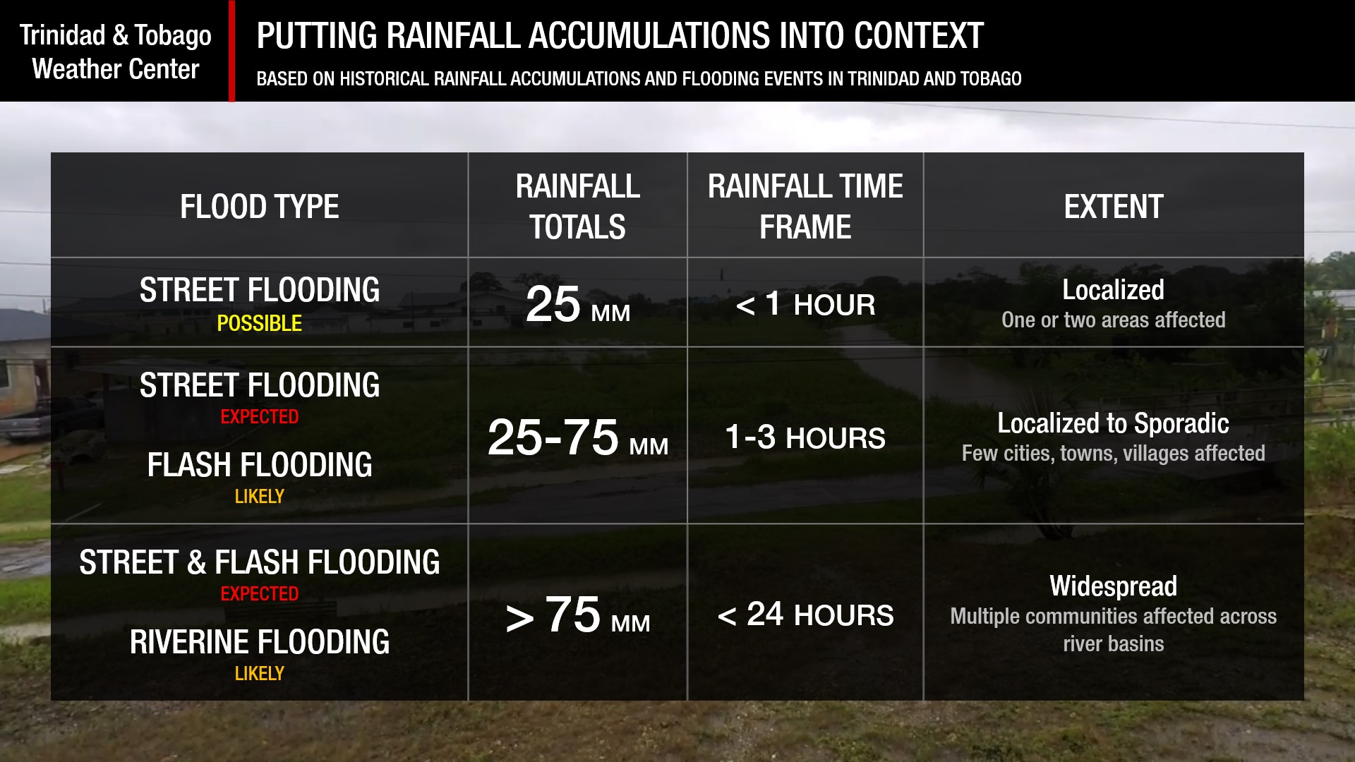
Understanding Rainfall Accumulations
Putting the rainfall forecast into context, rainfall rates in excess of 50 millimeters per hour or areas that receive in excess of 25 millimeters within an hour tend to trigger street flooding across the country or flash flooding in northern Trinidad. For riverine flooding to occur, a large area of the country (not just in highly localized areas of western coastal Trinidad) would have to record upwards of 75 millimeters within 24 hours, and rainfall would have to fall across major rivers’ catchment areas.
Strong Thunderstorms
Strong ThunderstormsWhat is a strong or severe thunderstorm?
Given how rare these types of thunderstorms are in our region – we classify a severe or strong thunderstorm as one that produces any of the following:
- Damaging wind gusts exceeding 63 KM/H;
- Frequent lightning (more than 30 cloud-to-ground strikes within a 10-minute period);
- Hail (of any size);
- Rainfall of more than 50 millimeters or more within an hour or exceeding 75 millimeters or more within three hours;
- The sighting of a funnel cloud or touchdown of a waterspout/tornado associated with the thunderstorm.
Gusty Winds
Gusty WindsWith wind gusts exceeding 45 km/h, whole trees can be in motion, with larger trees and weaker branches falling. Light outdoor objects can topple or become airborne, such as garbage cans, loose galvanize, construction material, and outdoor furniture. Tents may also jump.
Other Hazards
Saharan Dust concentrations are forecast to be mild to non-existent through the next five days.
Saharan Dust Forecast

Next Saharan Dust Surge Forecast By Mid-Next Week
Why I May Not/Will Not See Rainfall?
A frequent complaint is that the forecast is wrong because I didn’t experience any rainfall. Scattered showers mean that you, individually, may experience some showers intermittently throughout the day, and there is a higher chance for this activity than for isolated activity. Widespread showers mean that nearly all people and areas can expect rainfall.
Scattered rainfall is forecast over the next three days.

Forecast Discussion
From Saturday, a combination of anomalous moisture, light to moderate wind shear, favorable low-level convergence, and upper-level divergence is forecast to produce mostly cloudy to cloudy skies, periods of rain, showers, and thunderstorms across Trinidad, Tobago, and the Windward Islands.
Tropical Wave 43 is forecast to move across the area on Saturday night through Sunday, interacting with the Intertropical Convergence Zone. Then, Tropical Wave 44 (being monitored by the National Hurricane Center for possible development as it moves into the Caribbean Sea) is forecast to move across T&T and the Windwards on Sunday night into Monday, while interacting with the Intertropical Convergence Zone. However, when TW44 moves across the area, upper-level conditions become increasingly supportive of deeper convection, leading to stronger thunderstorms that can produce heavier rainfall and gusty winds into Monday. Based on the wind profile, funnel clouds are also possible.
While both top global models (ECMWF-European and GFS-American) show the atmosphere becoming progressively moist from Sunday, the GFS model shows a near-saturated atmosphere, with relative humidity exceeding 95%, extreme vertical instability, and veering winds (clockwise through the atmosphere) from the surface to the mid-levels, from 0 to nearly 7.5 kilometers into the atmosphere. This is one of the most extreme outputs from the GFS we’ve seen for T&T outside of a tropical cyclone, and within 48 hours of the forecast event. With extreme runs, we usually lean on the model’s trend to determine whether a particular run is anomalous. For the last eight runs of the GFS (since Wednesday), the GFS has stuck to its guns of having an extreme rainfall event occurring across T&T on Monday, with this latest run producing 24-hour rainfall totals as high as 150 millimeters of rain across Trinidad. Though heavy rainfall is still forecast, we still believe this is unrealistic, and beware of social media posts and videos showing these extreme model runs.
Using a combination of other leading global models and their ensembles, as well as high-resolution local models, atmospheric conditions are conducive to heavy rainfall on Saturday, but it is likely not as extreme as what the GFS is showing. Rainfall totals are forecast to be high, but not as extreme as those indicated by the GFS. Still, with forecast five-day rainfall totals as high as 150 millimeters, the risk of flooding in flood-vulnerable T&T is present, and high for street/flash flooding, while low to medium for riverine flooding.
By Tuesday and into Wednesday, trailing moisture and convergence associated with the Intertropical Convergence Zone will continue to keep showers and thunderstorms on tap for T&T, albeit more isolated.


