


As 2025 draws to a close, one more rainfall event is in the forecast for Trinidad and Tobago. A low-level trough is forecast to move across T&T on Saturday, bringing cloudiness, showers and possible thunderstorms from the late morning, ushering in a period of unsettled weather into Monday.
What you need to know
— What: A low-level trough is forecast to move across T&T on Saturday. Following the trough’s passage, elevated moisture from equatorial regions is forecast to move in from the southeast, aided by favorable low-level convergence. By Sunday, and to a lesser extent on Monday, an upper-level jet is forecast to provide support for thunderstorm activity.
— Where: Rainfall is forecast to occur across both islands, with overall higher rainfall accumulations favoring the eastern halves of both islands. Generally, between Saturday and Monday, 72-hour rainfall totals are forecast to reach 35 millimeters across both islands, with localized totals up to 50 millimeters in isolated areas. Between Tuesday and Wednesday, an additional 10-25 millimeters of rainfall is possible, with higher totals favoring eastern coastal Trinidad. Higher wind gusts are likely to favor Tobago and northern and eastern Trinidad.
— When: Scattered showers and thunderstorms, some of which may be locally heavy, are forecast to begin from late morning through the afternoon on Saturday, initially favoring eastern areas of Trinidad and Tobago, gradually moving westward across both islands. Intermittent showers and isolated thunderstorms are forecast across both islands through Monday.
— Impacts: Street/flash flooding and localized ponding are likely in heavy downpours, accompanied by gusty winds exceeding 50 km/h. Wind gusts exceeding 50 km/h are possible. These wind gusts, combined with heavy rainfall, may lead to fallen trees/utility poles/lines, as well as localized wind damage and agitated seas. In thunderstorm activity, frequent lightning is likely. At this time, chances of riverine flooding are low to very low.
— What Should You Do: Secure loose outdoor objects. If you encounter flood waters, turn around. If you hear thunder, head indoors. Motorists and residents in areas prone to flooding should remain alert and exercise caution. Be aware of your surroundings and changing weather conditions.
Latest Alerts

Localized Flood Alert Discontinued For Trinidad
Trinidad and Tobago is NOT under any tropical storm or hurricane threat, watch, or warning at this time.
The Forecast
Saturday
SaturdaySunday
SundayMonday
MondayTuesday
TuesdayWednesday
WednesdayMarine Forecast

Seas Forecast: Long-Period Swells To Return Next Week
Temperatures
Saturday
Low: 20-23°C
High: 30-32°C
Feels Like: 35-38°C
Sunday
Low: 22-24°C
High: 28-30°C
Feels Like: 30-35°C
Monday
Low: 21-24°C
High: 28-30°C
Feels Like: 30-35°C
Tuesday
Low: 21-24°C
High: 30-31°C
Feels Like: 33-38°C
Wednesday
Low: 21-24°C
High: 30-31°C
Feels Like: 33-38°C
Forecast Impacts
Flooding
Over the next five days, rainfall totals across the western half of Trinidad are forecast to range from 20 to 35 millimeters, while across eastern Trinidad and Tobago, rainfall totals are likely to range from 35 to 60 millimeters. In isolated areas, particularly along the east coast of Trinidad, totals of up to 75 millimeters are possible.
Though both islands are forecast to experience brief periods of locally heavy rainfall, overall rainfall totals are conducive to short-lived street flooding and flash flooding events, particularly in flood-prone and urbanized areas.
Street & Flash Flooding
Street & Flash FloodingRiverine Flooding
Riverine FloodingForecast Rainfall Totals
- Saturday: Across western Trinidad, and Tobago, between 5 and 15 millimeters, while across eastern Trinidad and Tobago, between 10 and 25 millimeters. In isolated areas across both islands, localized totals exceeding 25 millimeters are possible.
- Sunday: Across both islands, between 5 and 20 millimeters of rain are likely, with higher totals near and exceeding 25 millimeters favoring Tobago and eastern Trinidad.
- Monday: Up to 15 millimeters of rainfall across both islands, with lower totals across the western half of Trinidad. Across Tobago, and localized areas of Trinidad, totals up to 30 millimeters possible.
- Tuesday: Across the western half of Trinidad, up to 5 millimeters of rainfall forecast, with totals up to 10 millimeters of rainfall favoring Tobago and eastern Trinidad.
- Wednesday: Across the western half of Trinidad, up to 5 millimeters of rainfall forecast, with totals up to 10 millimeters of rainfall favoring Tobago and eastern Trinidad.

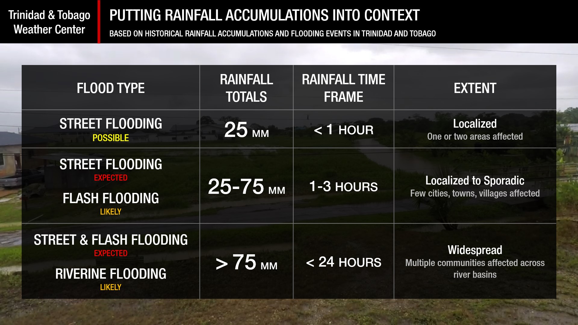
Understanding Rainfall Accumulations
Putting the rainfall forecast into context, rainfall rates in excess of 50 millimeters per hour or areas that receive in excess of 25 millimeters within an hour tend to trigger street flooding across the country or flash flooding in northern Trinidad. For riverine flooding to occur, a large area of the country (not just in highly localized areas of western coastal Trinidad) would have to record upwards of 75 millimeters within 24 hours, and rainfall would have to fall across major rivers’ catchment areas.
Strong Thunderstorms
Strong ThunderstormsWhat is a strong or severe thunderstorm?
Given how rare these types of thunderstorms are in our region – we classify a severe or strong thunderstorm as one that produces any of the following:
- Damaging wind gusts exceeding 63 KM/H;
- Frequent lightning (more than 30 cloud-to-ground strikes within a 10-minute period);
- Hail (of any size);
- Rainfall of more than 50 millimeters or more within an hour or exceeding 75 millimeters or more within three hours;
- The sighting of a funnel cloud or touchdown of a waterspout/tornado associated with the thunderstorm.
Gusty Winds
Gusty WindsWith wind gusts exceeding 45 km/h, whole trees can be in motion, with larger trees and weaker branches falling. Light outdoor objects can topple or become airborne, such as garbage cans, loose galvanize, construction material, and outdoor furniture. Tents may also jump.
Other Hazards
A short-lived but mild to moderate surge of Saharan Dust is forecast to move across T&T on Monday.
Saharan Dust Forecast

Next Saharan Dust Surge Forecast By Mid-Next Week
Why I May Not/Will Not See Rainfall?
A frequent complaint is that the forecast is wrong because I didn’t experience any rainfall. Scattered showers mean that you, individually, may experience some showers intermittently throughout the day, and there is a higher chance for this activity than for isolated activity. Widespread showers mean that nearly all people and areas can expect rainfall.
Scattered rainfall is forecast over the next three days, with isolated rain on Tuesday and Wednesday.

Forecast Discussion
A low-level trough is forecast to move across T&T on Saturday, with scattered showers and isolated thunderstorms trailing the trough axis. Following the trough, deep tropical moisture from the equator is forecast to move northward across T&T and the Windwards, with ample low-level to mid-level instability and low-level convergence supporting additional shower/thunderstorm activity. By Sunday, an upper-level jet is forecast to produce upper-level instability to support thunderstorm activity across the region, including across T&T. There are no alerts, watches, or warnings from the Trinidad and Tobago Meteorological Service at this time, and based on current model guidance as of Saturday morning, one is not warranted.
However, very strong west-southwest wind shear is forecast to keep overall heavier rainfall east of T&T and favor the eastern coastal areas of both islands. Additionally, a mild to moderate surge of Saharan Dust is forecast to move into the area on Sunday night and remain present through Tuesday morning, potentially limiting rainfall development.
Conditions begin to improve across T&T on Tuesday as the prevailing North Atlantic high-pressure system regains dominance, with low-level winds increasing by Wednesday and continuing into Thursday. As a result, low-level cloud patches may produce brief showers, accompanied by gusty winds, even if rainfall intensity is not moderate/heavy.


