


Earthquakes can be a devastating force of nature, capable of producing a multitude of hazards.
Primary Earthquake Hazards
Primary hazards are caused by the direct interaction of seismic wave energy with the ground.
Ground Shaking
Ground shaking is the main hazard associated with an earthquake. It can result in, beyond the panic of the population that feels the shaking, damage to infrastructure.
The severity of the shaking is dependent on the magnitude of the quake, the distance from the epicenter of the earthquake, the depth of the earthquake, and the geology of the area.
Magnitude
You will feel more intense shaking from a larger magnitude earthquake than from a small quake. Larger earthquakes release energy over a larger area for a more extended period.
An earthquake is not a rupture at a point but along a fault plane. As the rupture occurs along the fault, seismic waves are produced at every point. Hence, longer faults produce larger earthquakes that have longer durations.
For a magnitude 5.0 event, the rupturing over the fault occurs in a few seconds. The duration of shaking can be much longer. After reaching the surface, some waves can bounce and echo within the earth’s interior.
The rupture was complex for the M6.9 earthquake on August 21st, 2018. It lasted for approximately 27 seconds, while the shaking on the earth’s surface lasted nearly 90 seconds to 2 minutes.
Distance (& Depth)
The intensity of seismic waves decreases as it travels through the ground due to energy being dispersed. Hence, shaking is less intense farther from the fault, whether that be the distance from the epicenter (location of the earthquake on the earth’s surface) or the hypocenter (distance from the earthquake from within the earth).
In an earthquake, low and high-frequency waves are produced, with high-frequency waves (P-waves are the highest, then S-waves) diminishing rapidly with distance compared to low-frequency waves (Surface Waves – Love, Rayleigh).
If you are near the epicenter of an earthquake, you may feel a short “jolt” initially (P & S-Wave arrival), then a rolling motion (Surface Waves), whereas if you are further away, you may feel a rolling motion (Surface Waves).
Infrastructure damage does not solely depend on the intensity of shaking. Smaller buildings such as houses are more damaged by higher frequencies, versus larger structures such as high-rises and bridges are damaged by lower frequencies.
However, large, deeper earthquakes are more likely to be felt by a larger population than large, shallow quakes. The damaging surface waves (low-frequency) disperse more rapidly when traveling along the earth’s surface versus in the planet’s interior.
Geology
The soil of your area can significantly amplify the shaking of an earthquake. Seismic waves slow down, but the amplitude increases as the wave move from rock to soil. Soft, loose soil or landfill may shake more intensely than hard rock at the same distance from the same quake.
The thickness of loose soil can also play a part in ground shaking. Shaking from an earthquake in the region can be five or more times greater at a site in the basin than at the level of shaking in the nearby mountains.
Data has shown that shaking (ground motion) is amplified at mountain tops and ridges compared to the surrounding low-lying areas.
Note: Several other factors can affect shaking. Earthquake waves do not travel evenly in all directions from the rupture surface; the fault’s orientation and the movement’s direction can change the characteristics of the waves in different directions. When the earthquake rupture moves along the fault, it focuses energy in the direction it is moving so that a location in that direction will receive more shaking than a site at the same distance from the fault but in the opposite direction. This is called directivity.
Surface Rupture (Cracks/Fissures)
Surface ruptures can occur because of strong ground motion, causing the land to compress, dilate, or liquefy as a water-mud slurry forces its way to the surface.
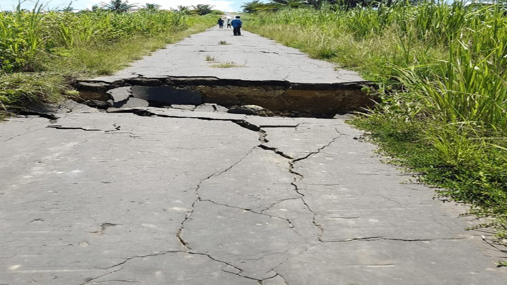
Normal- and reverse- (collectively called dip-slip) faulting surface ruptures feature vertical offsets, while strike-slip faulting produces lateral offsets. Many earthquake surface ruptures are combinations of both. Structures that span a surface fault are likely to suffer great damage from surface ruptures.
Secondary Earthquake Hazards
Secondary hazards are caused as a consequence of that ground shaking.
Landslides
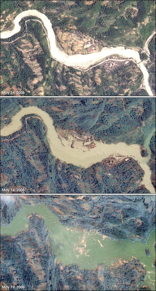
When an earthquake occurs, seismic waves cause ground shaking, destabilizing unstable slopes and triggering landslides or rockfalls. Heavy rain and unconsolidated or fractured rock are exacerbating factors.
Liquefaction
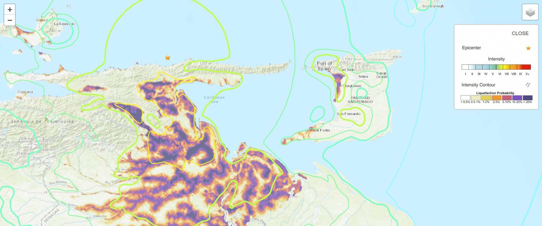
Liquefaction occurs in waterlogged or saturated soils, in which the space between sediment is completely filled with water. Typically, the water pressure will be relatively low within the soil, and loosely packed grains are held together by friction. During an earthquake, the groundwater pressure rises as the seismic waves destabilize the soil, increasing the spaces between sediment grains. With the soil structure lost, the soil behaves like a liquid.
Liquefied soil will force open ground cracks to escape to the surface. The ejected water-soil mixture can result in flooding.
Whether and where liquefaction will take place depends on many factors. These include the degree of saturation, the grain size distribution and consistency at a site, the strength, duration, and frequency content of the shaking, and even the grain shape and depth of soil. There is much active research into the mechanisms of liquefaction because its effects can be so severe, yet its process remains imperfectly understood.
During the strong M6.9 earthquake of August 21st, 2018, liquefaction occurred in Felicity, Trinidad – which verified the liquefaction probability map generated by the USGS.
Tsunami
Tsunamis are multiple, long-wavelength, long-period sea waves produced by the sudden displacement of a large volume of water. Tsunamis generated by an earthquake are usually due to vertical (and sometimes) horizontal changes along the seafloor that disrupt the water column. Earthquakes can also generate submarine or subaerial landslides that can trigger a tsunami.
A tsunami is one of the most powerful and destructive natural forces. Tsunamis radiate outward in all directions from the point of origin and can move across entire ocean basins. When they reach the coast, they can cause dangerous coastal flooding and powerful currents that can last for several hours.
While earthquakes account for most tsunamis across the globe, not all earthquakes can generate a tsunami. The University of the West Indies Seismic Research Center (UWI SRC) outlines the following criteria for tsunamigenesis:
- The earthquake must occur beneath the ocean or cause material to slide into or within the ocean.
- The earthquake must be strong, at least magnitude 6.5.
- The quake must rupture the Earth’s surface, and it must occur at a shallow depth – less than 70 kilometers below the surface of the Earth.
- The earthquake must cause vertical movement of the seafloor (up to several meters).
Tsunamis can devastate coastal communities and cities. It has the potential to cause significant loss of life and property damage. Tsunamis can also reshape coastlines and destroy marine and coastal habitats.
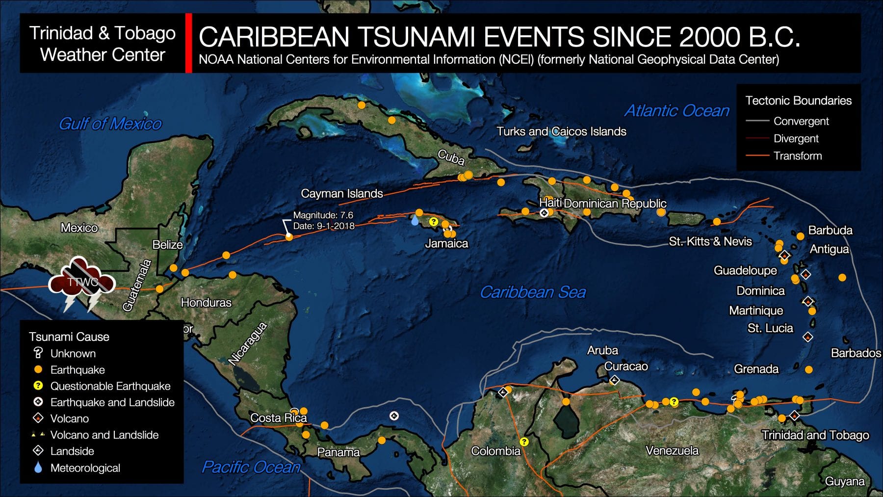
Thankfully, tsunamis are relatively rare across the Eastern Caribbean but not unheard of. Typically, tsunamis in the Eastern Caribbean have a recurrence period every 50 years. According to the NOAA National Centers for Environmental Information, the Caribbean has observed 105 tsunamis over the last 500 years.
Seiches
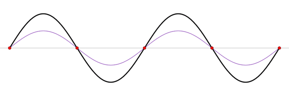
This animation shows a standing wave (black) depicted as a sum of two propagating waves traveling in opposite directions (blue and red). Like a seesaw, a seiche is a standing wave in which the largest vertical oscillations are at each end of a body of water with very small oscillations at the “node,” or center point, of the wave. Standing waves can form in any enclosed or semi-enclosed body of water, from a massive lake to a small coffee cup. (Credit: NOAA)
A seiche is a standing wave in an enclosed or partially enclosed water body. If you have observed water sloshing back and forth in a swimming pool, bathtub, or cup of water, you may have witnessed a small-scale seiche.
Seiches can be caused by earthquakes when seismic (surface) waves cause the body of water to slosh back and forth in a closed (pool, lake, dam) or partially closed (bays, Gulf of Paria) bodies of water. It can also be caused by tsunamis entering partially closed bodies of water such as bays or gulfs (Gulf of Paria, Maracas Bay, etc.).
Small scale seiches, such as those occurring within a pond, lake, or dam, may be minor, with unusual flooding near the water’s edge. In very rare cases, there may be some property or infrastructure damage. In the case of large-scale seiches, such as those that would occur in the Gulf of Paria or within bays of Trinidad, Tobago, or any other Eastern Caribbean island, these can become particularly destructive and produce tsunami-like effects.
Flooding
Flooding is not the first hazard you’d think of in the event of an earthquake, but it can and does occur.
Earthquakes can uplift the ground, causing rivers to flow upstream and flood low-lying areas. Quakes can also block stream and river flow due to incredible surface faulting or earthquake-triggered landslides.
Artificial drainage can also be destroyed in urban areas and broken high-pressure pipes, both contributing to or directly causing flooding.
As groundwater ruptures the surface, liquefaction events can also flood unsuspecting areas.
In catastrophic events, water barriers such as levees or dams can be breached or fail, causing a torrent of water to flood surrounding areas.
Fires & Power Outages
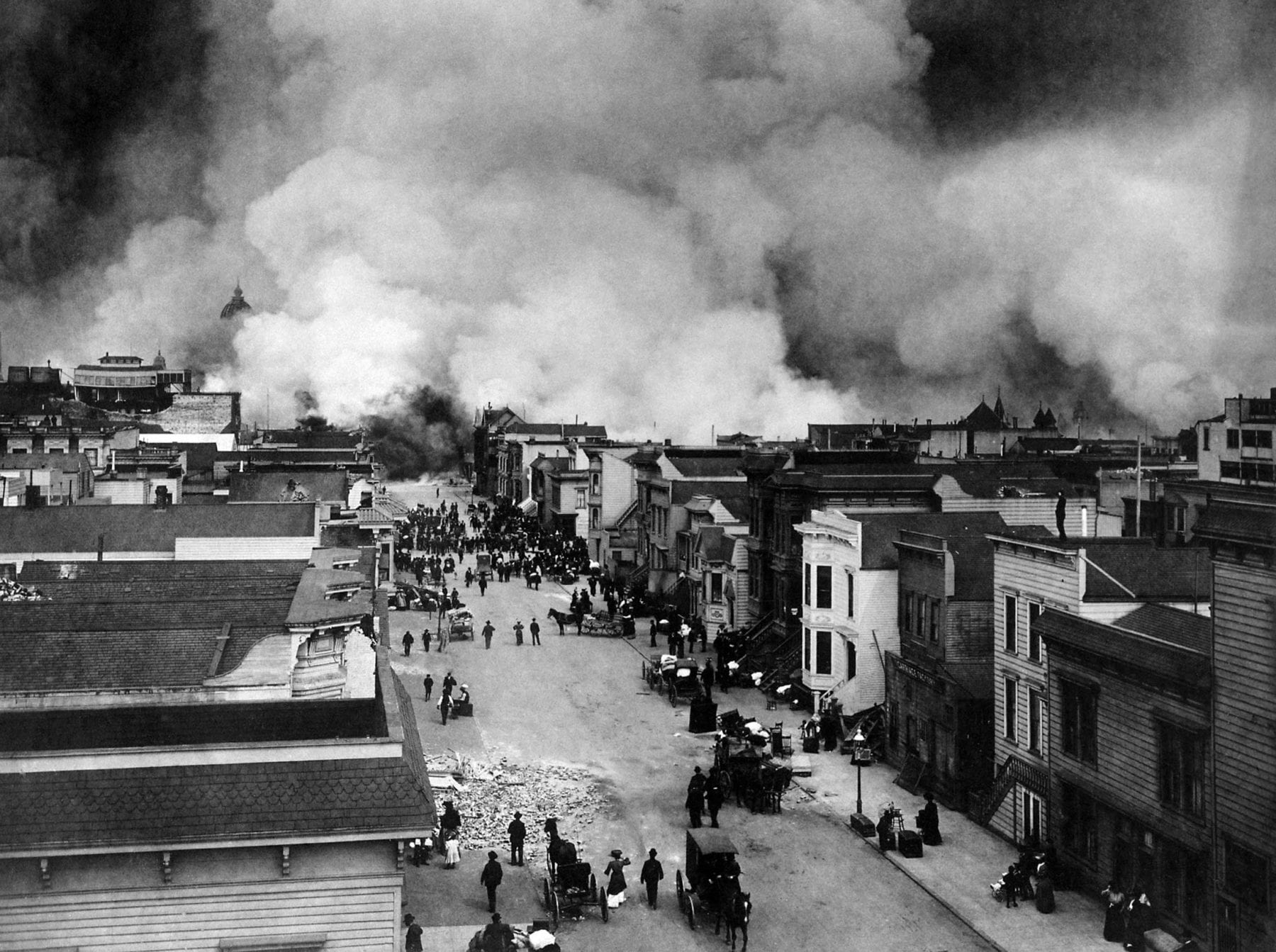
Large-scale fires associated with earthquakes are typically the result of broken gas lines or compromised electrical lines or equipment. This was the case in the 1906 San Francisco Earthquake which resulted in 90% of the damage resulting from the M7.9 quake that devastated 80% of the city.
Earthquakes can also lead to a compromised electrical grid. Downed power lines, utility posts, and even issues at power generation plants and substations can all contribute to outages post-earthquake.
Mud Volcanoes
There is an established link between large seismic events triggering mud volcano eruptions worldwide. In Trinidad and Eastern Venezuela, one of the many earthquake hazards is the eruption or formation of new mud volcanoes.
However, research has shown that in Trinidad, mud volcanoes have erupted during relatively seismically quiet periods (Deville & Guerlias, 2009)
Following the M6.9 earthquake on August 21st, 2018, both the Devil’s Woodyard and Piparo Mud Volcano erupted.
Update on the Piparo Mud Volcano from AAPG Young Professionals Trinidad & Tobago Chapter: Members of the AAPG visited the Piparo mud volcano this morning and noted fresh mud flow up to 1m from central vent. Constant hiss of gas and mud flows. SW-NE en echelon dextral fractures have appeared in various places with vertical throw of up to 3cm. Some N-S fractures also present with bubbles appearing along some. The AAPG will continue to monitor Piparo as we are hit by waves of aftershocks from the earthquake. Such aftershocks can potentially trigger a sizeable eruption due to the buildup of pressures at depth over the past 20 years. Video: AAPG Young Professionals Trinidad & Tobago Chapter
Posted by Trinidad and Tobago Weather Center on Wednesday, August 22, 2018
6:30PM Wednesday 22nd August 2018: More video from the Piparo Mud Volcano. Aftershocks from earthquakes can potentially trigger a sizeable eruption due to the buildup of pressures at depth over the past 20 years. Video: Rudra Narase
Posted by Trinidad and Tobago Weather Center on Wednesday, August 22, 2018