

The Venezuela doublet earthquakes
Sloshing Ponds, a Risen Coast, a Brand-New Island
What two earthquakes 780 kilometers away did to Trinidad, in a place that barely felt it.
Video: Navet, Trinidad (Shavon Goolcharan)
Two major earthquakes, striking within seconds of each other on June 24th, 2026, toppled buildings, killed over 4,000, and injured over 16,000 across western and north-central Venezuela as of July 12th, 2026. The quakes, registering magnitudes of 7.2 and 7.5, were among the strongest to hit Venezuela since 1900. The shaking reverberated across the region, including Trinidad and Tobago, where the scale of the effects is still becoming apparent more than two weeks after the quakes.
18:04:34 AST
The first rupture
A magnitude 7.2 earthquake strikes 27 kilometers beneath Yaracuy state, 21 km east-northeast of San Felipe, Venezuela. It is already one of the strongest earthquakes Venezuela has recorded in a century.
18:05:11 AST · plus 37 seconds
And then a second one
Before the first seismic waves have cleared the coastline, a magnitude 7.5 strikes on an adjacent segment 13 kilometers away and only 10 kilometers deep. Two great earthquakes, 37 seconds apart. Seismologists call it a doublet.
The fault
A crack that runs to Trinidad
The rupture was right-lateral, strike-slip: the San Sebastian segment of the Bocono–San Sebastian–El Pilar system. That system is the Caribbean–South America plate boundary, and it does not stop at Venezuela. It runs east through the Gulf of Paria and continues beneath Trinidad.
The cost
Caracas and La Guaira
The worst damage falls 160 kilometers east of the epicenters, in Caracas and along the La Guaira coast, where a reported 80% of buildings collapsed. As of July 11th, more than 4,300 people are confirmed dead and more than 16,700 injured, with tens of thousands still unaccounted for.
18:07 AST
Across the Gulf of Paria
The wavefront runs east along the same fault system it was born on, across the Paria peninsula and into the Gulf of Paria.
18:08:06 AST
Arrival
Three and a half minutes after the first rupture, and 780 kilometers away, the first surface waves reach Trinidad. Seismometers across the country record them.
18:09:58 AST
Thirteen minutes of it
The shaking peaks nearly six minutes after the rupture and does not subside. Peak acceleration is only 0.004 g, barely felt, but 99% of the energy arrives at a frequency that shakes high-rise buildings, soil, and water slowly and it keeps going for 13.5 minutes.
The south coast
Where it mattered
Small homes and most buildings do not generally respond to 17-second waves. Ponds do. Water-saturated soils do. And mud volcanoes, 26 of them along Trinidad's south coast, very much do.
Thirty-four seconds past 6:04 PM on Wednesday, June 24th, 2026, the first of two major earthquakes struck northwestern Venezuela – a magnitude 7.2 at a depth of 27 kilometers. Thirty-seven seconds later, before the first seismic surface waves had cleared the Venezuelan coastline, a second fault segment 13 kilometers away broke at a depth of only 10 kilometers. That one was a magnitude 7.5. Seismologists call two great earthquakes in quick succession on adjacent segments a doublet, a rare but not unseen feature in the Caribbean region. This one was the strongest earthquake in Venezuela since 1900.
Because both ruptures occurred on the same fault system, with similar focal mechanisms, seconds apart, the UWI Seismic Research Centre (UWI SRC) concluded they can be treated as a single massive event: one that shook the region for more than ten minutes.
What followed in Venezuela is still being counted. As of July 11th, more than 4,300 people are confirmed dead and more than 16,700 injured, with tens of thousands still unaccounted for. In La Guaira state, on the coast north of Caracas, a reported 80% of buildings collapsed. Satellite damage analysis by Corey Scher and Jamon Van Den Hoek at Oregon State University puts the number of buildings damaged or destroyed at roughly 69,431 as of July 9th. The United Nations estimates that up to 6.8 million people have been affected and puts the damage at around US$ 37 billion. The United States Geological Survey (USGS)issued a red alert, its highest, for both fatalities and economic loss.
In Trinidad, 780 kilometers to the east, most people on the ground felt nothing at all. The ones who did feel it were mostly high up, in taller buildings, where it registered as a slow, unsettling sway rather than a jolt.
And yet within days, part of Trinidad’s south-western coastline had risen by as much as 20 feet, a road at L’Envieuse had been torn in two and shifted sideways by 2 meters, reservoirs had sloshed over their banks, and a new island of mud had risen out of the sea off the south coast. This is how an earthquake that Trinidad barely registered rearranged its coastline, and what the seismic record actually shows.
- 0 s 18:04:34 M7.2 breaks beneath Yaracuy
- 37 s 18:05:11 M7.5 breaks on the adjacent segment
- 102 s 18:06:16 First P waves reach Trinidad
- 182 s 18:07:36 S waves reach Trinidad
- 212 s 18:08:06 First surface waves reach Trinidad
- 324 s 18:09:58 Shaking peaks
- 1,050 s 18:21:54 Long-period shaking finally falls away
A fault that runs to Trinidad
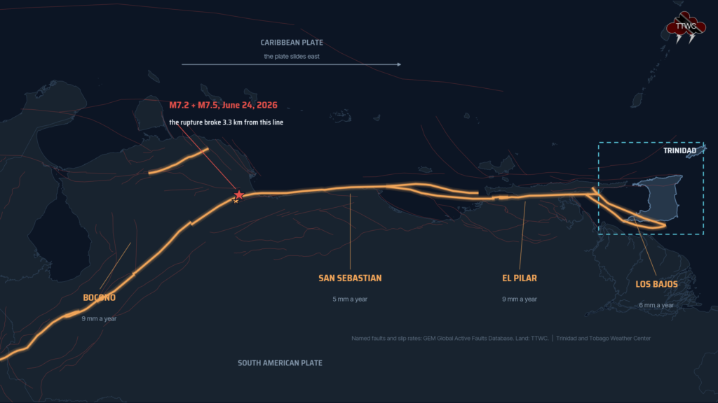
The rupture was right-lateral strike-slip: the two sides of the fault ground past each other horizontally, along a near-vertical plane running roughly east to west. The USGS finite-fault model has the magnitude 7.5 event tearing a 60-kilometer-long segment of the crust with a maximum slip of 3.6 meters, which matters because of where the fault goes.
Northern Venezuela is not a single fault line. It is a broad boundary zone where the Caribbean plate slides eastward past South America at roughly 10 millimeters a year. The principal structure in that zone is the Bocono-San Sebastian-El Pilar fault system. It runs more than 1,900 kilometers, from the Venezuelan Andes to the eastern edge of the country, and it does not stop there. Slip is transferred east through the Los Bajos fault and onto the Warm Springs fault, which runs across the Gulf of Paria and into Trinidad. The June 24th doublet broke the San Sebastian segment of the same system where Trinidad sits at its far eastern end.
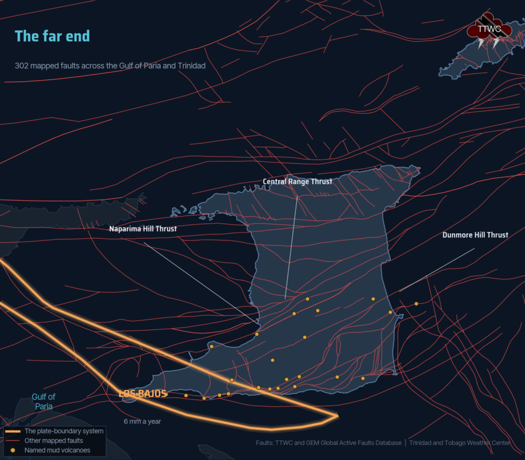
There is a second structure that matters just as much. Southern Trinidad is folded into the Southern Anticline, a major east-to-west arch of rock that runs the length of the island’s southern half and is riddled with faults. That arch is what allows pressurized water and mud to escape to the surface. It is why southern Trinidad has mud volcanoes at all, and it is why the damage on June 24th fell where it did.
What Trinidad actually felt
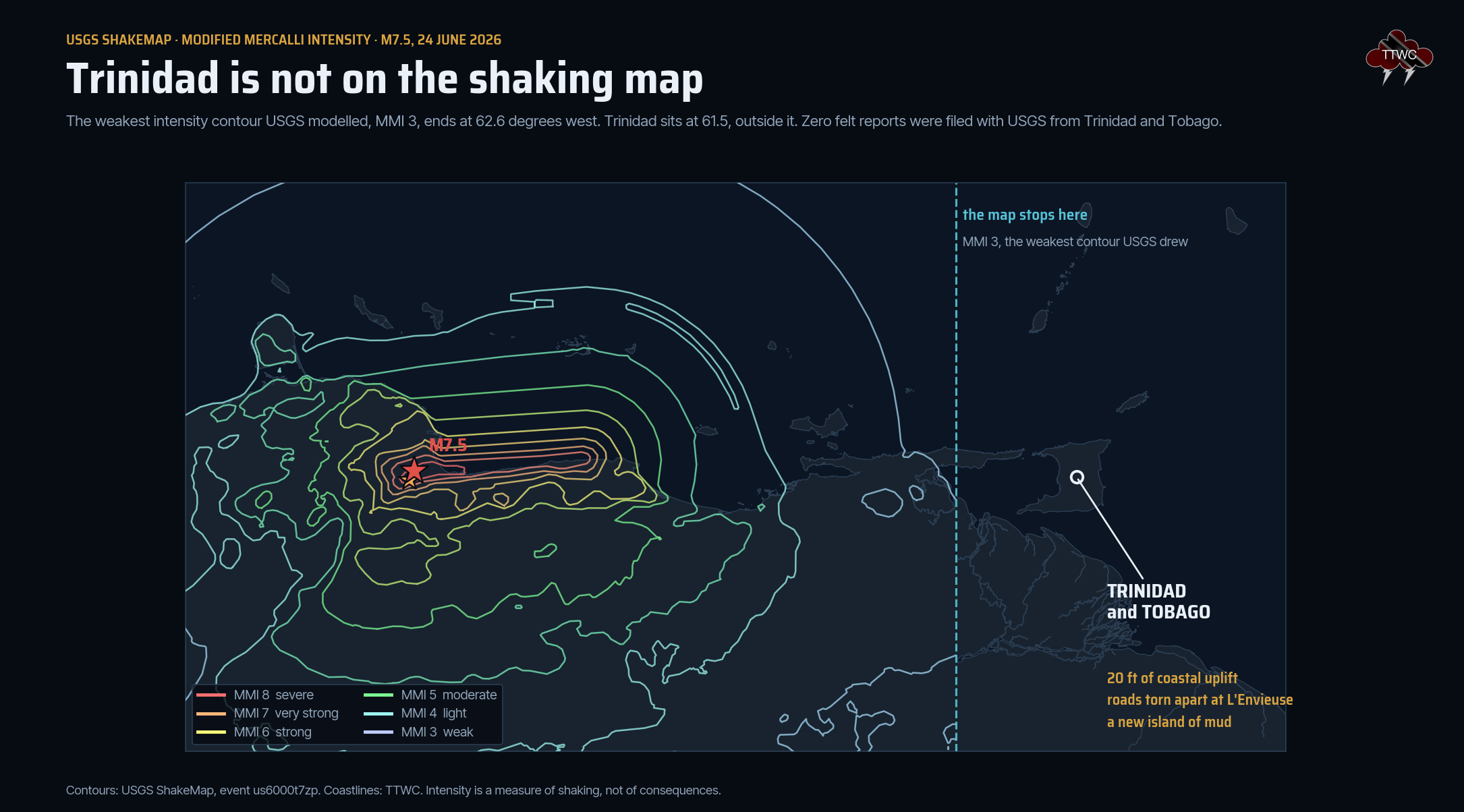
Not much, and not evenly. People in taller buildings, particularly on upper floors, reported a slow swaying that went on and on, but most of it wasn’t noticeable. Many people standing on the ground reported nothing at all.
The USGS “Did You Feel It?” system collected 732 responses for this earthquake from across Venezuela, Colombia, Aruba, Bonaire, and Curacao, Puerto Rico, Brazil, and as far as Bolivia and Peru. Not one came from Trinidad and Tobago. The lowest contour on the USGS ShakeMap, intensity III on the Modified Mercalli scale, stops west of Trinidad. In Tobago, there were a handful of felt reports and no impacts on the ground.
There was no tsunami threat to Trinidad and Tobago. The threat message covered coasts within 300 kilometers of the epicenter, which meant Venezuela and the ABC islands. A four-centimeter wave was recorded in Puerto Rico and a two-centimeter surge at Fort-de-France, Martinique.
So how did the southern coastline of Trinidad move?
To answer that, we went to the seismic record. There is exactly one instrument in Trinidad that captured this earthquake in a form the public can access: a Raspberry Shake citizen seismometer, station AM.R3E31, in north-central Trinidad, 780 kilometers from the rupture. It carries both a geophone and an accelerometer, so every number below can be checked twice on two instruments with completely different response curves. A second Raspberry Shake registered in Port of Spain was not streaming that evening and has no data for the event.
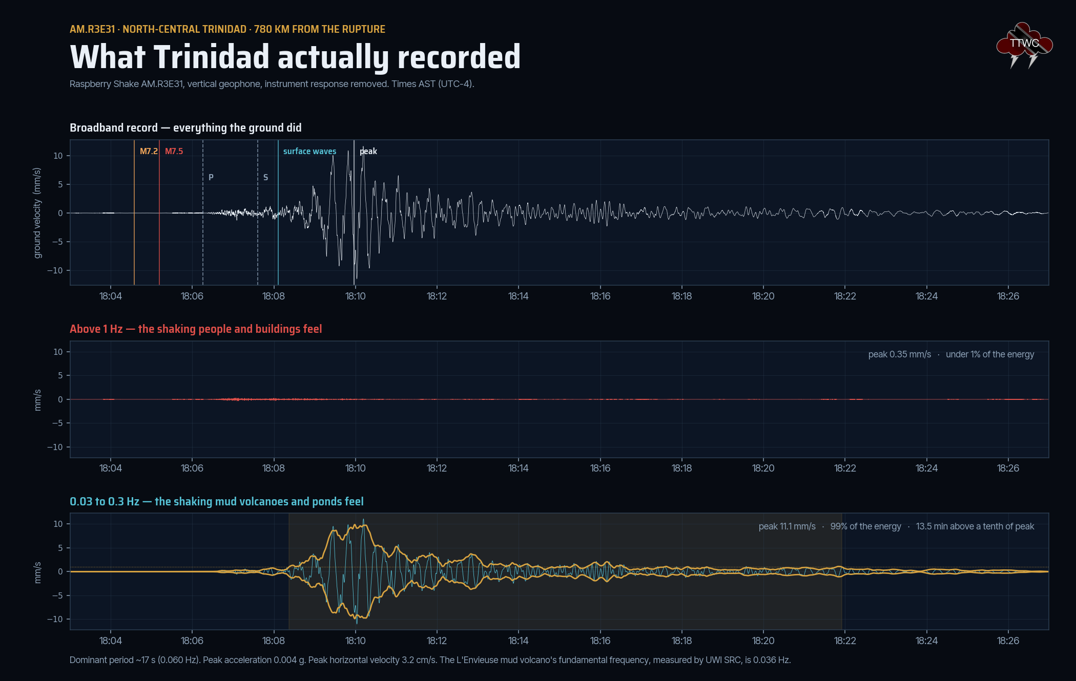
The first P waves reached the station at 18:06:16, one minute and 42 seconds after the rupture. The slow, heavy surface waves arrived at 18:08:06, three and a half minutes after it. The shaking peaked at 18:09:58, nearly six minutes after the ground first broke in Venezuela, and it did not let go. Long-period ground motion stayed above a tenth of its peak for 13.5 minutes.
Peak ground acceleration was 0.004 g. No building in Trinidad was ever structurally at risk from this earthquake. Peak velocity above 1 hertz, the band that people feel as sharp shaking, was 0.35 millimeters per second.
But 99% of the energy arrived below 0.3 hertz, with a dominant period of about 17 seconds, and peak horizontal ground velocity reached 3.2 centimeters per second. The ground was swaying, slowly and deeply, for a quarter of an hour.
That is exactly why the people who felt it were the people up high. A tall building has a long natural period. It responds to long, slow waves in a way that a person standing on a slab does not. The taller the structure, the more it answers to a 17-second push.
The UWI SRC measured 0.072 hertz on the east-west component at their Cedros station, at the other end of the island. We independently measure 0.060 hertz at 100 kilometers away, which agrees with the UWI SRC.
Why 780 KM changes the type of shaking that arrives
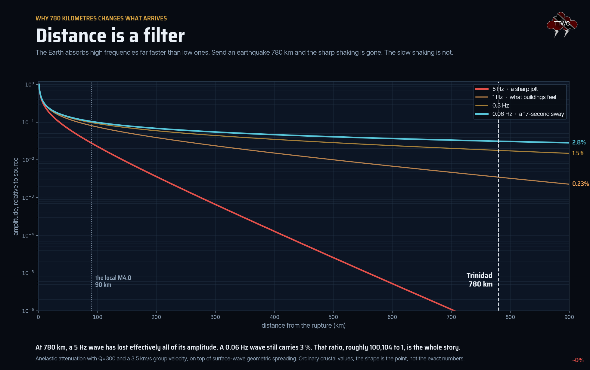
Seismic waves do not simply get smaller with distance. They get different. The Earth absorbs high frequencies far faster than low ones, so the further a wave travels, the more it is stripped of the sharp, fast content and the more it becomes a long, slow undulation. Send an earthquake 780 kilometers, and what arrives is not a weaker version of what left but a filtered version. It is also the reason why the 2018 M6.9 earthquake northwest of Trinidad wasn’t as damaging as the 2010 Haiti M7.0 – the 2018 quake was at a depth of 127 kilometers under the sparsely populated Paria Peninsula while Haiti’s quake was at a shallow 13 kilometers, in a densely populated area.
Fortuitously, at 4:19 PM that same afternoon, on June 24th, an hour and 45 minutes before the doublet, a magnitude 4.0 earthquake struck 67 kilometers north-west of Port of Spain, at a depth of 13.4 kilometers. It was located by the UWI SRC and was felt across parts of Trinidad.
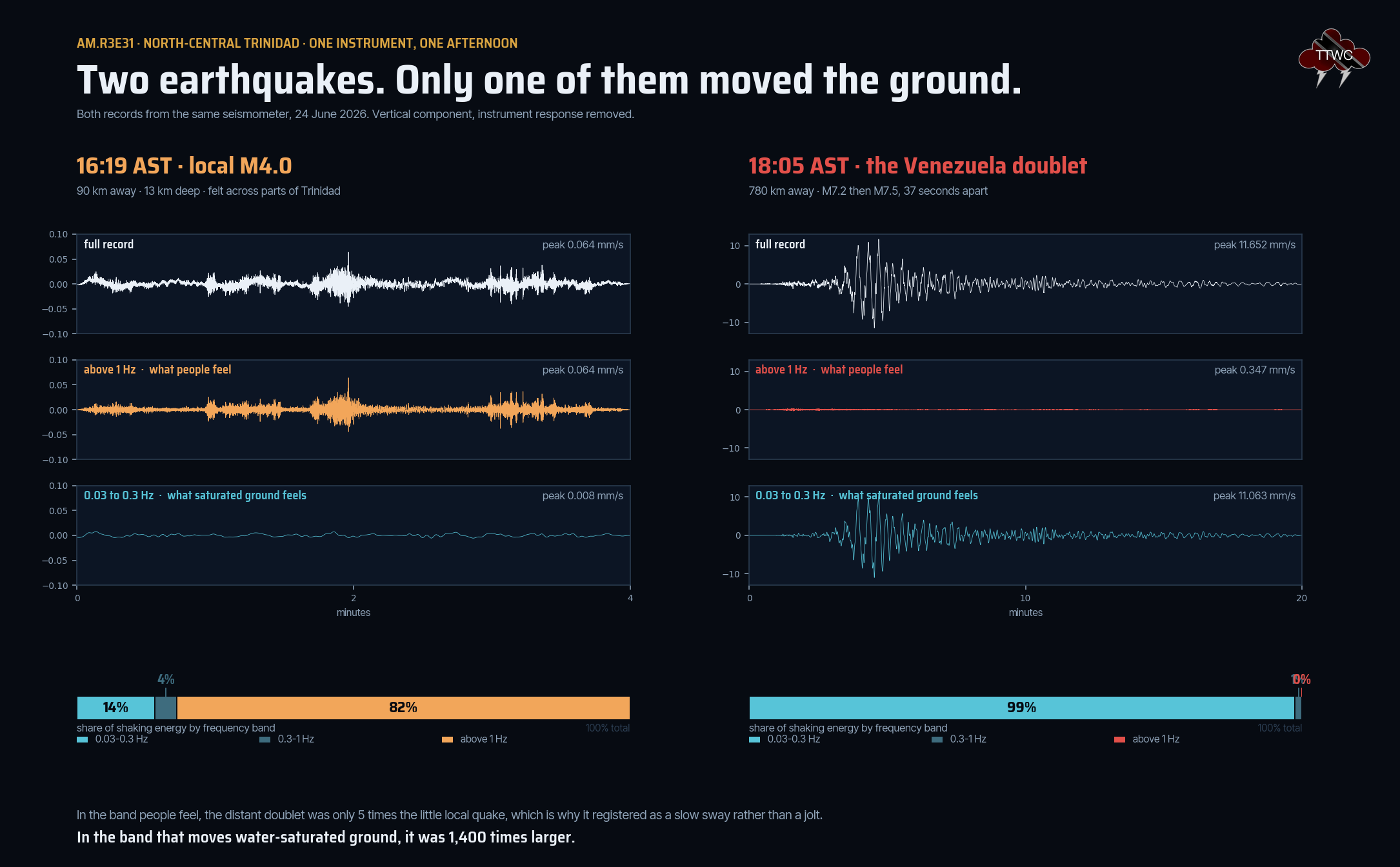
Split the two records by frequency, and they are near mirror images. The small local earthquake put 82% of its energy above 1 hertz, in the band people feel. The great distant one put essentially none there, and 99% of its energy below 0.3 hertz. Measured against each other, the numbers are stark. In the band people felt, the Venezuela doublet was only about five times the magnitude 4.0 down the road, which is why so few people noticed it. In the band that moves water-saturated ground, it was 1,400 times larger.
The water noticed first
No wind was blowing. Across southern and central Trinidad, water in ponds, reservoirs and pools began to slosh.
Video: Shavon Goolcharan
The first sign that something had happened was water moving where no wind was blowing.
Water in a closed or semi-closed basin has a natural period of oscillation, set by the basin’s length and depth. Push it at that period, and it sloshes back and forth long after the push has stopped. It is the same physics as tea or coffee slopping out of a mug carried at exactly the wrong pace. Seismologists call the result a seiche, and long-period surface waves are extremely good at causing them. A 17-second push is precisely the kind that reservoirs, ponds. and swimming pools answer to. The USGS has recorded seismic seiches in Norway from an earthquake in Alaska, more than 6,000 kilometers away. Now, we see it in action in Trinidad.
Most of the people filming did not feel an earthquake. They watched the water and knew something was wrong.
Galfa Point
A flat beach on the south-west peninsula rose by as much as 20 feet, and the coastline moved out to sea.
Drone: Edward Moodie
Galfa Point sits on the south coast of the Southwest Peninsula, near Cedros. It is known locally for mud volcanoes and for what comes up with them: pyrite, oil seeps, and oil sands with the Bonasse oilfield nearby. It is a landscape built out of soft sediment, clays, and sands and hydrocarbon-charged mud, saturated with water and gas, stacked on the flank of the Southern Anticline.
Geologists from Touchstone Exploration reached the site within days. Xavier Moonan, who led the visit, described a section of beach that would normally be quite flat, uplifted by as much as 20 feet, with areas immediately to the west and east showing no uplift and no damage at all. As a result of the uplift, he reported, the coastline had shifted seaward by at least 100 feet. The most arresting detail in his account is about speed.
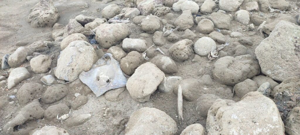
The rate of uplift appears to have been very rapid/instantaneous. This is based on the many marine creatures that were trapped and exposed to air by the uplift. We even saw what appears to be a stingray crushed by an uplifted boulder, suggesting there was no time for the creature to react and get out of harm’s way.
Xavier Moonan, Touchstone Exploration
What actually happened to the beach
The mechanism is a rotational slump with a toe thrust, and the phrase does a lot of work, so it is worth unpacking.
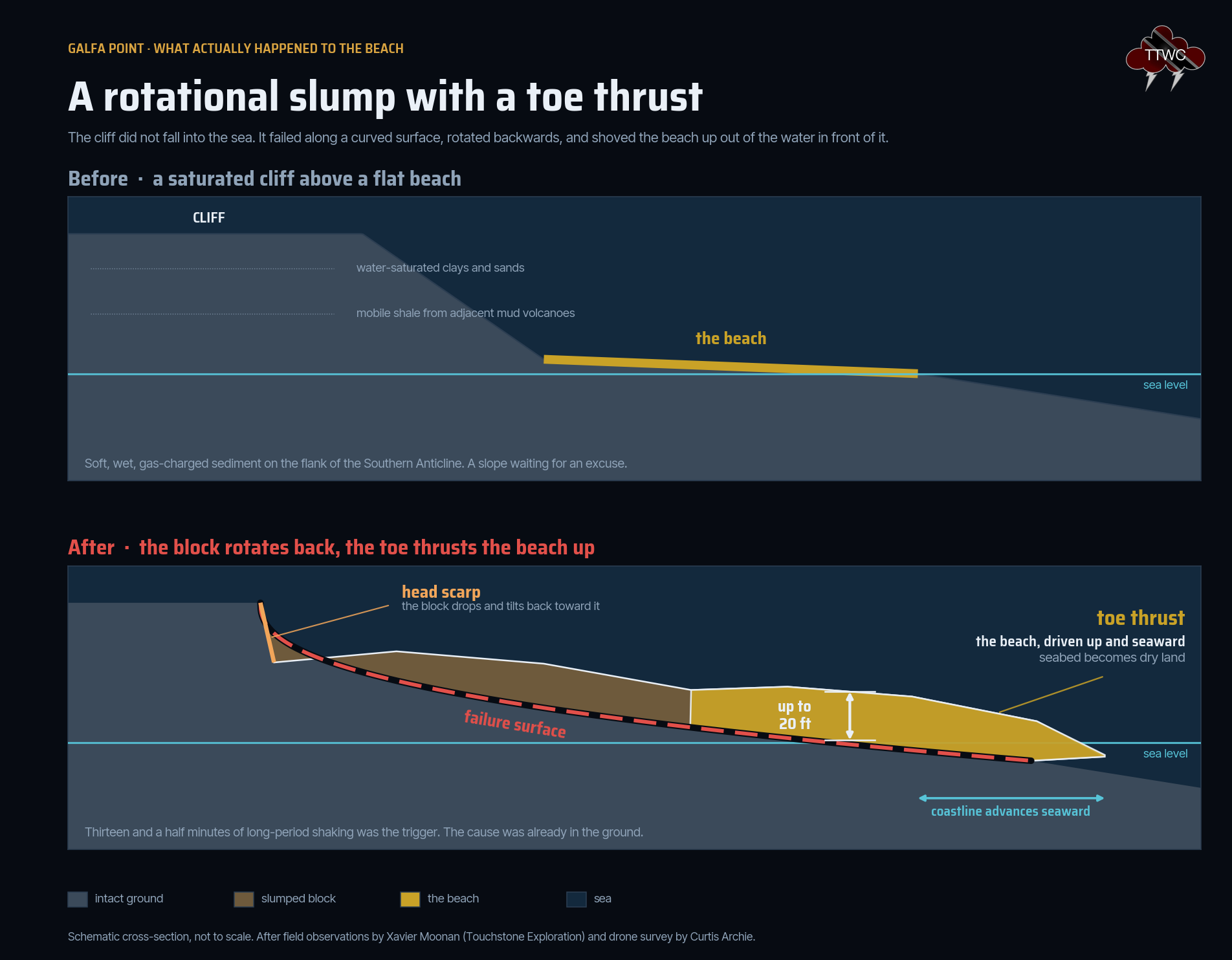
A block of saturated ground behind the coastal cliff failed along a curved surface. At the top, it dropped and tilted backward, leaving a scarp. At the bottom, where that curved surface daylighted below sea level, it shoved the seabed upward and outward. What had been underwater became a beach. The uplifted ground has a stepped appearance, which is the toe thrust itself: sheets of material driven up and over one another.

Moonan attributes the failure to the coastal cliffs slumping: soil and rock that is water-saturated is prone to collapse, aided by mobile shales from the adjacent mud volcanoes. A tear fault at Galfa, he suggests, may have moved subtly during the Venezuelan shaking, destabilizing the cliff section, triggering the slump, which then generated the beach uplift. Within the uplifted ground itself are numerous faults and fractures, dominantly right-lateral strike-slip, with some of the largest offsets showing purely extensional motion.
Geologist Curtis Archie flew a drone over the site at 150 feet, in true and false color. The false-color elevation map is where the mechanism becomes unmistakable: it shows the upslope failure scarp cleanly.


A former oil seep has been reactivated by the faulting and slumping, leaving multiple bubbling pools with slicks of oil across the new ground. This is not beach sand pushed up. It is deep, gas-charged sediment brought to daylight.

How far did the coast move?
It depends who you ask, and on what they were measuring, and we think both answers belong here.
Our own analysis of Sentinel-2 imagery puts the coastline at Galfa Point about 85 meters further seaward than it was on May 4, 2026, seven weeks before the earthquake, and about 90 meters further seaward at L’Envieuse. Moonan’s field measurement on June 27 put the shift at at least 100 feet, around 30 meters.
The two are not measuring the same thing. The satellite sees the boundary between land and water on one specific date, and where that boundary falls depends on the state of the tide when the satellite passed overhead. The field measurement was tracking a physical feature, days earlier, while the slump was still settling. We are publishing both, with their methods stated, rather than choosing the number we prefer. The 20 feet of uplift is not in dispute.


Asked whether the area could be stabilized, Moonan’s answer was brief – it will only feasibly happen naturally. It is safe enough to visit, he said, but visitors should watch their step. The new ground is covered in dead fish, crabs, stingrays, and uplifted boulders.
Damage at L'Envieuse
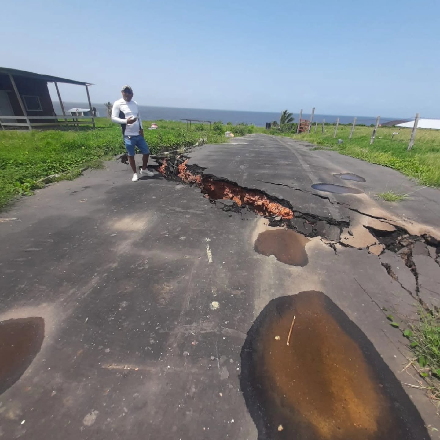
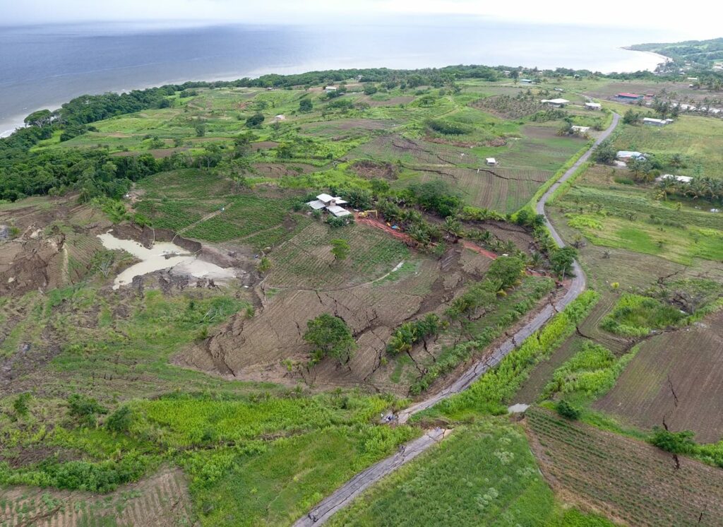
Two and a half kilometers west of Galfa, the ground did not rise. It broke, and everything east of the break moved 2 meters sideways.
Photo: Edward Moodie, July 6, 2026
A fault running roughly north-west to south-east cut clean across St. Quintin Road in the L’Envieuse community. It broke the road surface, the concrete drains, and the fences, and damaged nearby homes.
By matching features on either side of the break, Moonan measured about 2 meters of right-lateral movement. Scrape marks on the fault surface, known as slickensides, confirm the motion was lateral. In his words, all the land and houses east of the fault line moved as a single solid mass, 2 meters to the east. The fault continues northward, toward cleared land at the crest of the hill.
Why here? The UWI SRC‘s preliminary report contains the finding that ties the whole story together, and it is about frequency.
The ground at the L’Envieuse mud volcano has a fundamental frequency, the rate at which its soil and rock layers naturally vibrate, of about 0.036 hertz. That is one full swing every 28 seconds. The waves arriving from Venezuela had a dominant frequency of about 0.072 hertz: one crest every 14 seconds. Exactly twice as fast.
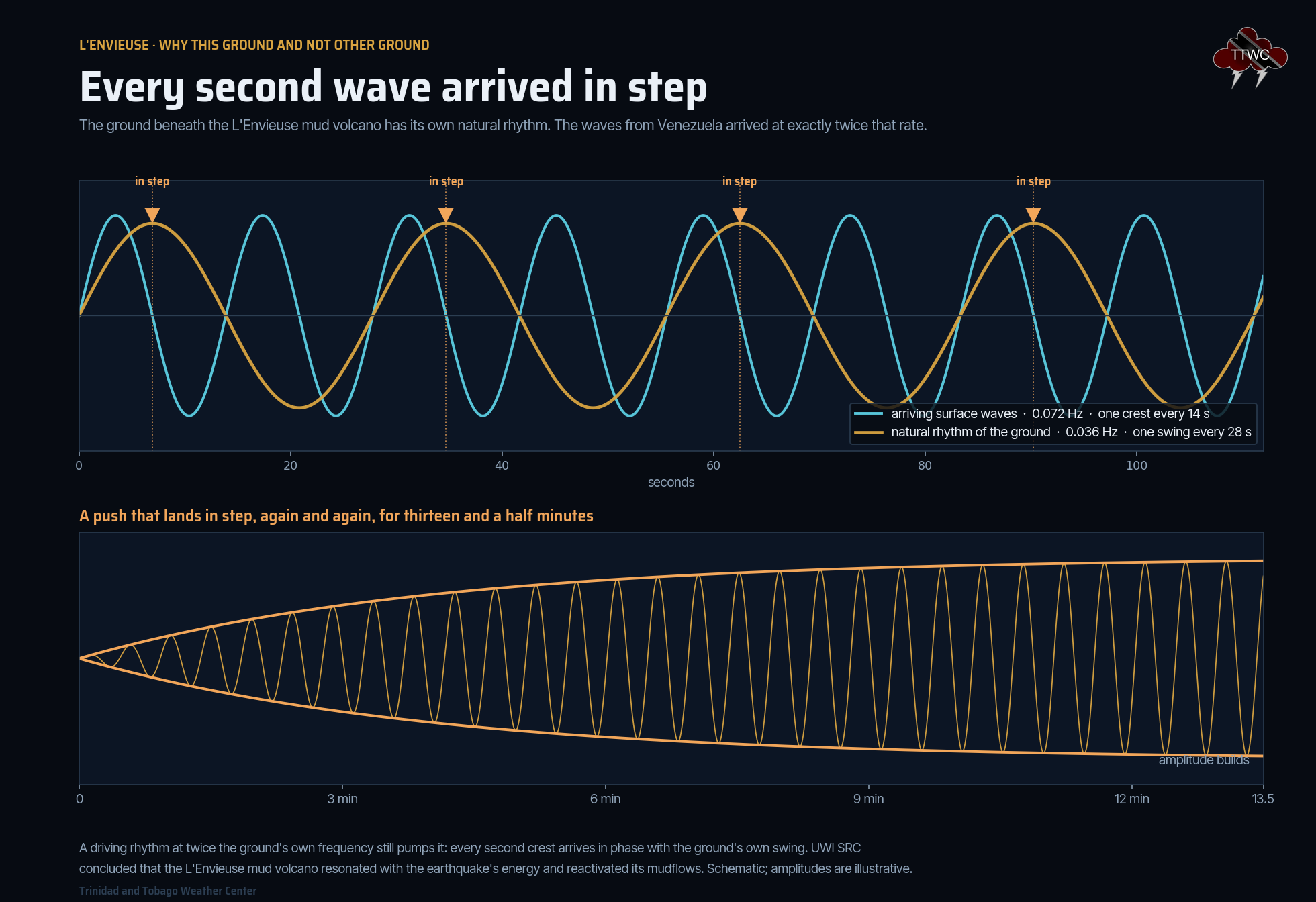
A push that lands at exactly twice a system’s natural rate still pumps it: every second crest arrives in phase with the swing it is driving. The SRC concluded that the mud volcano resonated with the earthquake’s energy and that this reactivated its mudflows. Thirteen and a half minutes of that is a very long time to be pushed in step, and according to the UWI SRC, these symptoms are to be expected on the south coast and in other areas of similar geology after large enough earthquakes, and efforts must be made to mitigate future risk to lives and livelihoods
in these susceptible areas.
The Los Iros Warning
Moonan draws a comparison that should worry anyone living on that coast. In August 2018, a magnitude 6.9 earthquake near Trinidad led to a similar landslide at Los Iros. Farmers reported land split open, ponds emptied, equipment swallowed by cracks. The behavior of the fault movement at L’Envieuse, he says, is very similar to the 2018 aftermath at Los Iros. And Los Iros did not stop moving.
Some 7 years later in Los Iros, the land became further unstable and slipped 3-4x the original amount, leading to widespread damage.
Xavier Moonan, Touchstone Exploration
The slope down to the sea at L’Envieuse is gentler than at Los Iros, which helps. But the open cracks and the cleared land will let rainwater into the fault zone, and water in a fault zone makes it more prone to slipping. Moonan’s recommendation is practical: vegetate the land along the fault zone, reduce the amount of bare soil and open cracks exposed to rainfall. It will slow the slippage down but will not stop it. His assessment is that further slippage is inevitable.
Columbus Mud Volcano erupts
Trinidad’s mud volcanoes are concentrated almost entirely along the southern half of the island, following the grain of the Southern Anticline and the faults within it. Devil’s Woodyard, Piparo, Moruga Bouffe, Erin Point, Chatham, Galfa Point, Columbus. They are not volcanic in the igneous sense: they are the surface expression of over-pressured, gas-charged mud finding a way up through the sediment column. There are 26 named ones and 13 further mapped vents that carry no name at all. They are exquisitely sensitive to being shaken.
The Columbus Mud Volcano, the westernmost of them on shore, covers around 180 acres by the 2014 lidar survey and has two main vents: an active one to the north and a dormant one to the south. On June 21st, three days before the earthquake, both looked as they always had. By June 26th, the northern vent had turned a dark brown, and by July 3rd, it had gone grey. Based on satellite imagery of previous eruptions at other mud volcanoes, as well as our observations and calculations, this was a fresh eruption that covered approximately 1.2 acres of new mud.


Two things that were not there before
Neil's Mud Volcano Island
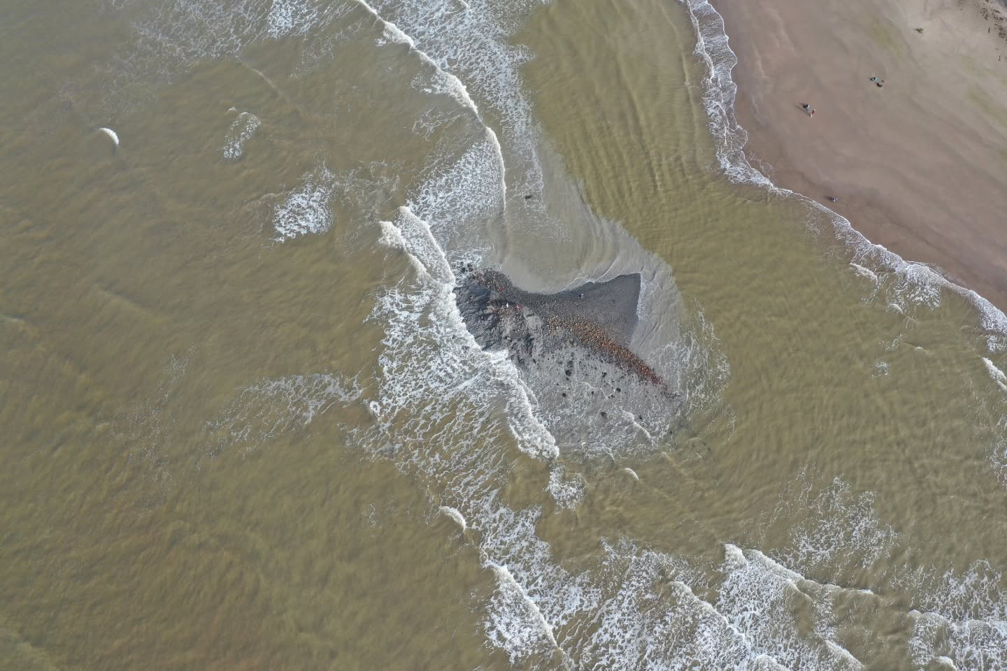
Twenty-nine kilometers east of Columbus, an island of mud rose out of the sea. It is already washing away.
Photo: Xavier Moonan, July 11, 2026
Neil Sookram is not a geologist. He is a digital creator and an outdoor enthusiast on Trinidad’s south coast, and he runs a YouTube channel called Southwest Adventures. He found one of the mud volcanoes first, and while it will likely be short-lived as it gets eroded by waves and tides, Neil’s Mud Volcano Island off the south coast of Trinidad will be written into history.
About 2.5 kilometers east of Beach Camp, and 3.3 kilometers east of the Anglais Point mud volcano, a temporary island of extruded mud volcano material now stands roughly 12 feet above the seabed. It is made predominantly of soft swelling clays with boulders and rock fragments caught up in them. The boulders are hard, contain significant calcite, and in places look coralline. Mud samples have been sent to Resilog to establish their relative age.
It is disappearing as fast as it arrived. From Sookram’s own footage, about one-third of the island has already been washed away by the waves. That rapid loss is itself the evidence: an island that erodes this quickly cannot have been there long, which is what makes it very likely that the extrusion was triggered by the Venezuelan earthquakes. Off Trinidad’s southwestern coast, in the Columbus Channel, mud volcanoes of this nature have been known to form and be quickly eroded on the order of days or weeks.
And crucially, this is not another Galfa. The beach and the cliffs beside it show no damage, uplift, or movement, with no slumps. This is mud that came up from below, at a spot that was primed for it: within a kilometer to the east lies the easterly dipping Santa Flora Fault, and the island may sit at the intersection of an extensional splay off that fault and a thrust fault belonging to the Southern Anticline.
Two and a half kilometers further east again, and 4.6 kilometers east of Beach Camp, the satellite record shows something else.
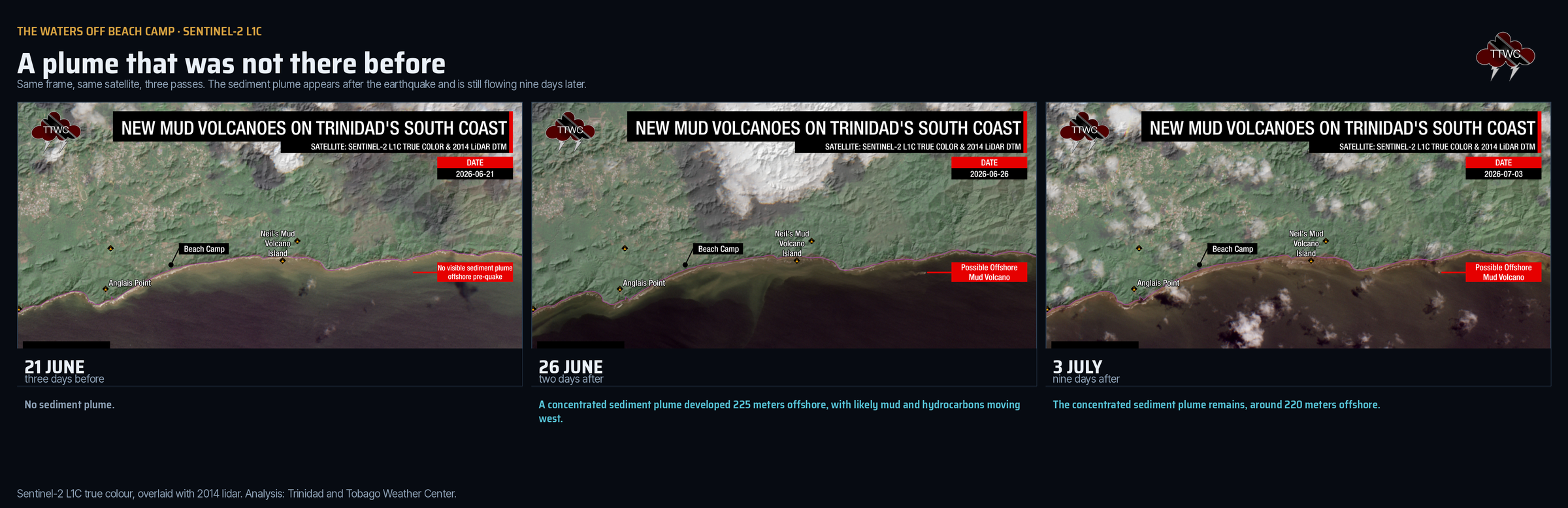
On June 21st, three days before the earthquake, the water was clear. On June 26th, two days after it, a pronounced sediment plume was observed. On July 3rd, the plume was still there. A plume that appears after an earthquake and continues to flow has a source on the seafloor. The most likely explanation is a new submarine mud volcano that is still discharging. This second volcano was discovered by TTWC during a review of recent satellite imagery.
What this tells us
Trinidad is 780 kilometers from where the ground broke, far enough for the sharp, high-frequency shaking that damages buildings to fade away almost entirely, which is why so few people felt it and why not a single report was filed with the USGS. It was not far enough for the long, slow surface waves, which fade far more slowly, and which are exactly what soft, saturated ground responds to. The very thing that made this earthquake harmless to Trinidad’s buildings, its distance, is what filtered the shaking down to the frequencies that moved Trinidad’s coast.
A national intensity map showing nothing over Trinidad, and a felt-report database with zero entries from Trinidad, would together tell you that nothing happened here. Twenty feet of uplift at Galfa, 2 meters of lateral movement at L’Envieuse, and a new island of mud say otherwise. Ground-failure hazard and shaking hazard are not the same map, and along the south-west peninsula, the first one matters. The SRC’s own conclusion is that these symptoms are to be expected after any large enough earthquake, anywhere in the region.
We saw almost all of this from public data. One citizen seismometer, free satellite imagery, and photographs and video from people who went and looked. Trinidad and Tobago has, as far as we can determine, exactly one seismic instrument that captured this event in a form the public can access. The SRC’s own researchers have been warning that seismic monitoring across the Caribbean is too thin: Dr Abayomi Osotuyi of the Seismic Research Centre said recently of the region’s earthquakes that these are expected
, and that the monitoring network has, in his words, quite a lot to do. UWI SRC only has one seismometer in Trinidad’s southwest – TTCC (Cedros).
Nothing about June 24 was a surprise to the rocks. The Bocono, San Sebastian, and El Pilar system will move again. So will the Los Bajos fault, and the Warm Springs fault, and the faults threading through the Southern Anticline. Those ones are not 780 kilometers away, and when they move, the shaking may not be filtered by 780 kilometers of Earth first.