


Tornadoes are among the most violent atmospheric storms we experience. A tornado is a narrow, violently rotating column of air that extends from a thunderstorm to the ground. Since wind is invisible, it is hard to see a tornado unless a condensation funnel of water droplets, dust, and debris, forms. In Trinidad and Tobago, tornadoes are historically uncommon. However, the country has recorded at least one tornadic event annually in the last few years.
What is a tornado?
A tornado is a violently rotating column of air in contact with the ground, generally extending from a thunderstorm. For this vortex of air to be classified as a tornado, it must be in contact with both the base of the cloud and the ground. However, a tornado refers to the vortex of wind touching the ground, not necessarily the condensation funnel. In T&T, since tornadoes are fairly short-lived and weak, these intense rotating air columns touch down, causing debris and dust to spiral into the air, but we don’t typically see a funnel touch down.
The Tornado Life Cycle
Formation
NEW: Video of the Chase Village Tornado on Wednesday 14th October 2020.
— TTWeatherCenter (@TTWeatherCenter) October 18, 2020
The details: https://t.co/WcmZXuYhGn pic.twitter.com/JLI1KLqUDX
Specifically for Trinidad and Tobago, tornadic activity occurs when winds are light to near calm near the surface. Higher in the atmosphere, winds remain stronger and even from a different direction – this is known as vertical wind shear.
For example, when winds at the ground level are calm or light, we may see surface winds come from the west (Gulf of Paria) or south (when a tropical cyclone is north of the country). However, slightly higher in the atmosphere, around 5000 feet in the same location, winds generally move easterly and at a higher speed. This invisible tube of air (seen below) begins to rotate horizontally. Shear, however, is not enough to cause a funnel cloud or tornado.
We also need convection – meaning showers or thunderstorms – to develop. Within convection, there is an updraft. An updraft is a narrow band of warm, moist air that feeds into a developing shower or thunderstorm.
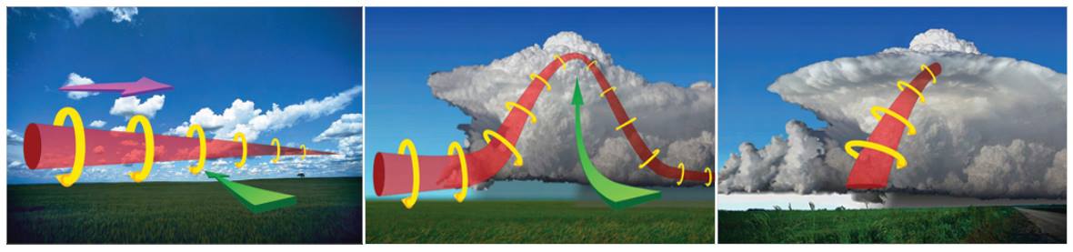
Rising air within a thunderstorm tilts the rotating air from horizontal to vertical – now, the area of rotation extends through much of the storm. This rotating updraft is now called a mesocyclone.
Within a mesocyclone, there is the rising air – the updraft – and an area of quickly descending air known as a downdraft. This downdraft drags the rotating mesocyclone down to the ground and takes in cool, moist air from the downdraft region of the storm.
This downdraft area focuses the mesocyclone’s base, causing it to draw air from a smaller and smaller area on the ground. As the updraft intensifies, it creates an area of low pressure at the surface. This pulls the focused mesocyclone down, and a funnel cloud can form. Tornadoes generally begin their life cycle has a funnel cloud, but not all funnel clouds develop into a tornado. Most tornadoes produce strong winds at the surface while the visible funnel is still above the ground (see the 2019 Port of Spain Tornado).
If the column of air touches the ground, we have a tornado! Alternatively, it becomes a waterspout if it touches down on the water.
As the funnel descends, the downdraft also reaches the ground, fanning outward and creating a gust front that can cause severe damage a considerable distance from the tornado. Usually, the funnel cloud becomes a tornado, causing damage within a few minutes of the downdraft reaching the ground.
Maturity
When a tornado forms, the thunderstorm has a good source of warm, moist air flowing towards it, and it grows until it reaches a “mature” stage. In T&T, tornado activity generally reaches this mature stage within minutes, which is when the most damage is caused. In other places globally, where stronger tornadoes are more frequent, a tornado can be at this mature stage for more than an hour.
With a mature tornado, the downdraft, which becomes an area of cool winds at the surface, begins to wrap around the tornado, cutting off the warm air that previously fed the updraft and the tornado.
Dissipation
As the cool air from the downdraft completely cuts off the tornado’s warm air supply, the vortex begins to weaken and can become thin and rope-like. This is the dissipating stage and lasts no longer than a few minutes. It is important to note that even though a tornado is becoming thinner and more of a rope-like tube, it can still produce damage.
Although this is a widely accepted theory for how most tornadoes form, live, and die, it does not explain the formation of smaller tornadoes, such as landspouts, long-lived tornadoes, or tornadoes with multiple vortices. These each have different mechanisms which influence their development—however, most tornadoes follow a pattern similar to this one.
Tornado Types
Supercell
You’ve now read (above) quite extensively about the formation and dissipation of a supercell tornado. Nearly all tornadoes we’ve tracked in the last two decades have formed from supercell thunderstorms. However, even if a supercell thunderstorm is present, and this type of thunderstorm is already rare in T&T, it doesn’t guarantee a tornado to form. According to NOAA, there are still many unanswered questions about supercell tornadoes, given as few as 20 percent of supercell thunderstorms actually produce tornadoes.
Non-Supercell Tornadoes
Most thunderstorms in Trinidad and Tobago are not supercells. The most common are single-cell thunderstorms and can be called “popcorn” convection. They are small, brief, and primarily weak storms that grow and die within 60-90 minutes.
They form from colliding air masses generally from the Gulf of Paria and prevailing easterly winds during the Wet Season or unusually moisture-laden and unstable air across the region during the Dry Season.
We occasionally experience multi-cell thunderstorms where new updrafts form along the leading edge of rain-cooled air (the gust front). Individual cells usually last 30 to 60 minutes, while the system as a whole may last for many hours. These multi-cell thunderstorms are also common in squall lines associated with Tropical Waves or feeder bands of a tropical cyclone.
Tornadoes forming from these non-supercell thunderstorms tend to be weaker and even shorter-lived on average than those associated with supercell thunderstorms.
Waterspouts
JUST IN: Waterspout spotted off of Erin Bay, Los Iros. This is the forth tornadic event recorded in and around Trinidad in the last 4 days.
— TTWeatherCenter (@TTWeatherCenter) August 17, 2021
Live updates: https://t.co/4AwGYEz7cY pic.twitter.com/dAA13qBOLT
A waterspout is a column of wind that can become cloud-filled, rotating over a body of water. Waterspouts are not unheard of in Trinidad and Tobago, with several sightings reported and documented over the last few years.
These rotating columns of air over water can become damaging and life-threatening if it nears boats at sea, in harbors, or it can even move on land, becoming a tornado.
Landspouts
Another type of non-supercell tornado is a landspout. A landspout is a tornado with a narrow, rope-like condensation funnel that forms while the thunderstorm cloud grows, and there is no rotating updraft – the spinning motion originates near the ground. These have not been documented in T&T to date.
Non-Tornadic Circulations
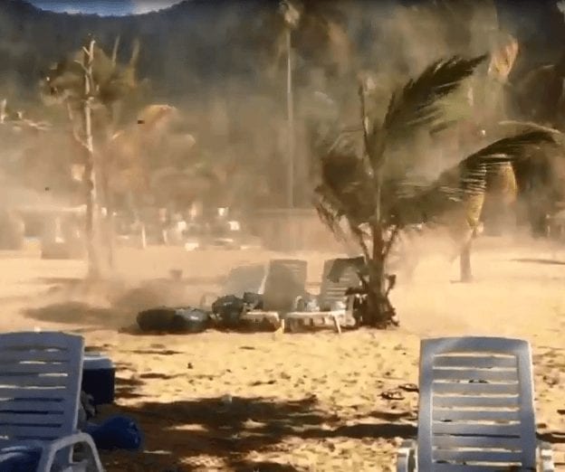
Gustnadoes
This is a rare feature for Trinidad and Tobago and occurs along the leading edge of straight-line winds associated with microbursts or downbursts. It is short-lived, on the order of seconds to a minute. We rarely have, if ever, seen this feature in recent records.
Dust Devils
Dust devils form when hot air near the surface rises quickly through a small pocket of cooler, lower pressure air above it. As the air rises, this column of hot air is stretched vertically. If conditions are just right, the air may begin to rotate. With more hot air at the surface flowing into this rotating air column, replacing the rising air, the spinning effect intensifies and is self-sustaining. Typically, these fast current of surface winds whips up dust to show the wind currents.
Hot air near the surface is channeled up the dust devil. Eventually, surrounding cooler air will be sucked in. Once this occurs, the effect is dramatic, and the dust devil dissipates in seconds.
A dust devil needs:
- Flat conditions increase the likelihood of the hot-air “fuel” being a near-constant. Dusty or sandy conditions will cause particles to become caught up in the vortex, making the dust devil easily visible.
- Clear skies or lightly cloudy conditions: The surface needs to absorb heat to create ideal dust devil conditions.
- Light or no wind and cool atmospheric temperature.
- Most dust devils are very small and weak, often less than 3 feet (0.9 m) in diameter, with maximum winds averaging about 45 miles per hour (70 km/h), and they often dissipate less than a minute after forming.
Fire Whirls
Small-scale, tornado-like circulations can occur near any intense surface heat source (like above in dust devils). Those that occur near intense wildfires are called fire whirls. They are not considered tornadoes, except in the rare case where they connect to a pyrocumulus or other cumuliform cloud above. Fire whirls usually are not as strong as tornadoes associated with thunderstorms. They can, however, produce significant damage. This feature has not been documented in T&T to date.
Characteristics
Size and Shape
BREAKING (1:20 PM) Tornado touches down at Ragoonanan Road West, near Perseverance Road off Orange Field, Chase Village.
— TTWeatherCenter (@TTWeatherCenter) October 14, 2020
There are a number of homes damaged with roofs blown off. https://t.co/ZlICurcNQq pic.twitter.com/R53qJQ7A9C
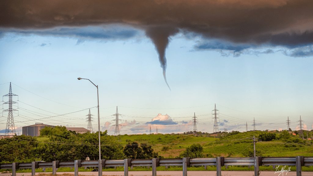
Most tornadoes appear as a narrow funnel with a small cloud of debris near the ground in Trinidad and Tobago. Rarely do we see the condensation funnel (or the funnel cloud) extend to the ground, but the narrow area of strong winds causes debris to be lifted hundreds of meters into the air in a spiral pattern.
Globally, a tornado with a nearly cylindrical profile and relatively low height is sometimes referred to as a “stovepipe” tornado. Large tornadoes that appear at least as wide as their cloud-to-ground height can look like large wedges stuck into the ground and so are known as “wedge tornadoes” or “wedges.”
When tornadoes begin to dissipate, particularly those where the condensation funnel (or the funnel cloud) extends to the ground, it can resemble a narrow tube or a rope and can often curl or twist into complex shapes. These tornadoes are said to be “roping out” or becoming a “rope tornado.” When they rope out, the length of their funnel increases. This roping out forces the winds within the funnel to weaken due to the conservation of angular momentum.
In the United States, tornadoes are around 500 feet (150 meters) across on average and travel on the ground for 5 miles (8 kilometers). Based on our observations, most tornadoes since 2009 across Trinidad have had a width of fewer than 100 meters and travel on the ground for up to a kilometer.
However, there is a wide range of tornado sizes. Weak tornadoes, or strong yet dissipating, can be exceedingly narrow, sometimes only a few feet or a couple of meters across. One tornado was reported to have a damage path only 7 feet (2.1 m) long.
On the other end of the spectrum, wedge tornadoes can have a damage path a mile (1.6 km) wide or more. A tornado that affected Hallam, Nebraska, on May 22nd, 2004, was up to 2.5 miles (4.0 km) wide at the ground, and a tornado in El Reno, Oklahoma, on May 31st, 2013, was approximately 2.6 miles (4.2 km) wide, the widest on record.
Colors
Tornadoes can have a wide range of colors, depending on the environment in which they form. Those that form in dry environments can be nearly invisible, marked only by swirling debris at the base of the funnel. Condensation funnels that pick up little or no debris can be gray to white. While traveling over a body of water (as a waterspout), tornadoes can turn white or even blue. Slow-moving funnels, which ingest a considerable amount of debris and dirt, are usually darker, taking on the color of debris.
Forecasting and Detection
Video taken from Mausica Road also show debris being lifted and rotated into the air.
— TTWeatherCenter (@TTWeatherCenter) October 18, 2020
Sometimes, the rapidly rotating column of air gets in contact with the ground *without* a funnel cloud touching down, which is known as a tornado without a funnel.https://t.co/IE9FvmKhua pic.twitter.com/WZ4q85DDFx
We tend to look for light to near calm conditions in the forecasting phase, particularly along Western Trinidad, where triggering mechanisms for shower and thunderstorm development are dominated by sea breeze convergence and daytime heating.
Looking at different heights in the atmosphere, we also monitor if there is a vertically stacked low-pressure, with a noted, decreasing temperature change and a clockwise turning of winds as you increase in height in the atmosphere.
However all of these conditions can occur, but it does not guarantee the formation of a tornado. This is where detection comes in, as tornado events tend to be brief.
We lack the advanced Doppler Radar in Trinidad and Tobago to show how winds move near and inside showers. However, as of early 2022, Barbados is upgrading its radar system to a Dual-Polar Radar which would help us understand what kinds of hazards the thunderstorm might have (tornado, microburst, gust fronts, etc.) associated with it. It also helps us understand how the thunderstorm is “feeding” itself with warm, moist air.
However, even if we had an advanced Doppler Radar, there would be difficulty in recognizing the small low-level circulations on Doppler radar. This difficulty in forecasting such events results in short, if any, warning times for the public with a limited warning distribution network.
Intensity and Damage

Unlike tropical cyclones, where direct wind measurements can occur to determine the storm’s strength before impacting land, a tornado’s localized and small nature makes these measurements nearly impossible.
Tornado intensity can be measured by in situ or remote sensing measurements, but since these are impractical for wide-scale use, intensity is usually inferred by proxies, such as damage.
The most popular scales used are the Fujita scale and the Enhanced Fujita scale, both rate tornadoes by the damage caused. The Enhanced Fujita scale was an upgrade to the older Fujita scale, with engineered wind estimates and better damage descriptions, but was designed so that a tornado rated on the Fujita scale would receive the same numerical rating.
An EF-0 tornado will probably damage trees and peel some shingles off the roof. An EF-5 tornado can rip well-anchored homes off their foundations.
Doppler radar data, photogrammetry, and ground swirl patterns (cycloidal marks) may also be analyzed to determine the intensity and assign a rating.
Tornadoes vary in intensity regardless of shape, size, and location, though strong tornadoes are typically larger than weak tornadoes. The association with track length and duration also varies, although longer track (and longer-lived) tornadoes tend to be stronger.
Based on damage from tornadoes in T&T in recent history, nearly all events are approximately EF-0 strength.
Occurrence and Frequency
It seems like we may have had our 3rd tornado touchdown for 2020 on Thursday afternoon. Based on reports & satellite imagery, the funnel cloud touched down northwest of Charlieville in the Caroni Swamp.
— TTWeatherCenter (@TTWeatherCenter) October 29, 2020
This activity is possible in strong thunderstorms: https://t.co/PAPoJ5CA3u pic.twitter.com/U9mX9FBCe1
More confirmed observations of tornadoes have been made across Trinidad (mainly) and Tobago in recent years. The verdict is still out on whether this increase is attributed to increased cameras and media reports across the country rather than increased frequency.
Here are a few instances of tornadoes across Trinidad and Tobago from 2009 to 2021:
- Caroni Plains EF-0 Tornado (August 9th, 2009)
- Cunupia EF-0 Tornado (September 16th, 2019)
- Port of Spain EF-0 Tornado (October 22nd, 2019)
- Chase Village EF-0 Tornado (October 14th, 2020)
- D’Abadie EF-0 Tornado (October 18th, 2020)
- Caroni Swamp Tornado (October 29th, 2020)
- Los Iros EF-0/EF-1 Tornado (August 16th, 2021)
Tornado Safety
Weather forecasting science is not perfect, and some tornadoes occur without a tornado warning. In Trinidad and Tobago, unlike the United States, radar capabilities limit our ability to detect tornadoes. Also, there is no centralized area for issuing a tornado warning to the population. Hence, your best option is to stay aware of the latest weather forecasts, and there is no substitute for staying alert to the sky.
Besides an obviously visible tornado, here are some things to look and listen for from NOAA NWS Storm Prediction Center:
- Strong, persistent rotation in the cloud base.
- Whirling dust or debris on the ground under a cloud base — tornadoes sometimes have no funnel!
- Hail or heavy rain followed by either dead calm or a fast, intense wind shift. Many tornadoes are wrapped in heavy precipitation and can’t be seen.
- Day or night – Loud, continuous roar or rumble, which doesn’t fade in a few seconds like thunder.
- Night – Small, bright, blue-green to white flashes at ground level near a thunderstorm (as opposed to silvery lightning up in the clouds). These mean power lines are being snapped by the very strong wind, maybe a tornado.
- Night – Persistent lowering from the cloud base, illuminated or silhouetted by lightning – especially if it is on the ground or there is a blue-green-white power flash underneath.
If you spot a funnel cloud, head indoors to the lowest level of the nearest building, into a center room away from windows and doors. While some funnel clouds may never materialize into a tornado, gusty winds may still occur and can be hazardous.
Before a Tornado
- Be alert of your surroundings and the weather forecast: Trinidad and Tobago’s radar does not allow for the monitoring of wind velocities, and other radar detected features that would allow a meteorologist to issue advanced tornado warnings. Also, there is no centralized medium for tornado warnings to be expediently disseminated to the public for warnings to be utilized in a short time frame. Hence, your greatest tool will be to be alert and aware of your surroundings and keep up to date on weather forecasts issued by your local meteorological services and offices.
- Sign Up for Notifications: If you live in an area where such alerts exist, know how your community sends warnings. Again, thankfully, we live in an area where tornadoes are relatively infrequent, so alerts such as outdoor sirens are not needed. However, media and smartphones can be used to alert residents of severe storms capable of producing tornadoes.
- Create a Communications Plan: Have a family plan that includes an emergency meeting place and related information. Pick a safe room in your homes, such as a basement, storm cellar, or an interior room on the lowest floor with no windows.
- Practice Your Plan: Conduct a family severe thunderstorm drill so everyone knows what to do if a tornado or funnel cloud is approaching. Don’t forget pets if time allows.
- Prepare Your Home: Consider having your safe room reinforced.
- Help Your Neighbor: Encourage your loved ones to prepare for the possibility of tornadoes. Take CPR training so you can help if someone is hurt.
During a Tornado
- In a house with no basement, a dorm, or an apartment: Avoid windows. Go to the lowest floor, small center room (like a bathroom or closet), under a stairwell, or in an interior hallway with no windows. Crouch as low as possible to the floor, facing down; and cover your head with your hands. A bathtub may offer a shell of partial protection. Even in an interior room, you should cover yourself with some sort of thick padding (mattress, blankets, etc.) to protect against falling debris in case the roof and ceiling fail. A helmet can offer some protection against head injury.
- In an office building, hospital, nursing home, or skyscraper: Go directly to an enclosed, windowless area in the center of the building — away from glass and on the lowest floor possible. Then, crouch down and cover your head. Interior stairwells are usually good places to take shelter, and, if not crowded, allow you to get to a lower level quickly. Stay off the elevators; you could be trapped in them if the power is lost.
- In a mobile home: Get out! Even if your home is tied down, it is not as safe as an underground shelter or permanent, sturdy building. Go to one of those shelters, or a nearby permanent structure, using your tornado evacuation plan. Most tornadoes can destroy even tied-down mobile homes; it is best not to play the low odds that yours will make it.
- At school: Follow the drill! Go to the interior hall or windowless room in an orderly way, as you are told. Crouch low, head down, and protect the back of your head with your arms. Stay away from windows and large open rooms like gyms and auditoriums.
- In a car or truck: Vehicles are extremely risky in a tornado. There is no safe option when caught in a tornado in a car, just slightly less-dangerous ones. If the tornado is visible, far away, and the traffic is light, you may be able to drive out of its path by moving at right angles to the tornado. Seek shelter in a sturdy building or underground, if possible. If you are caught by extreme winds or flying debris, park the car as quickly and safely as possible — out of the traffic lanes. Stay in the car with the seat belt on. Put your head down below the windows; cover your head with your hands and a blanket, coat, or other cushions if possible. If you can safely get noticeably lower than the level of the roadway, leave your car and lie in that area, covering your head with your hands. Avoid seeking shelter under bridges, which can create deadly traffic hazards while offering little protection against flying debris.
- In the open outdoors: If possible, seek shelter in a sturdy building. If not, lie flat and face-down on low ground, protecting the back of your head with your arms. Get as far away from trees and cars as you can; they may be blown onto you in a tornado.
- In a shopping mall or large store: Do not panic. Watch for others. Move as quickly as possible to an interior bathroom, storage room, or other small enclosed areas, away from windows.
- In a church or theater: Do not panic. If possible, move quickly but orderly to an interior bathroom or hallway, away from windows. Crouch face-down and protect your head with your arms. If there is no time to do that, get under the seats or pews, protecting your head with your arms or hands.
After a Tornado
- Stay Informed: Continue to listen to local news to stay updated about weather conditions.
- Contact Your Family and Loved Ones: Let your family and close friends know that you’re okay so they can help spread the word. Text messages or social media are more reliable forms of communication than phone calls.
- Assess the Damage: After the threat of tornadoes has ended, check to see if your property has been damaged. When walking through storm damage, wear long pants, a long-sleeved shirt, and sturdy shoes. Contact local authorities if you see power lines down. Stay out of damaged buildings.
- Help Your Neighbor: If you come across injured people and you are properly trained, provide first aid to victims if needed until emergency response teams arrive.