


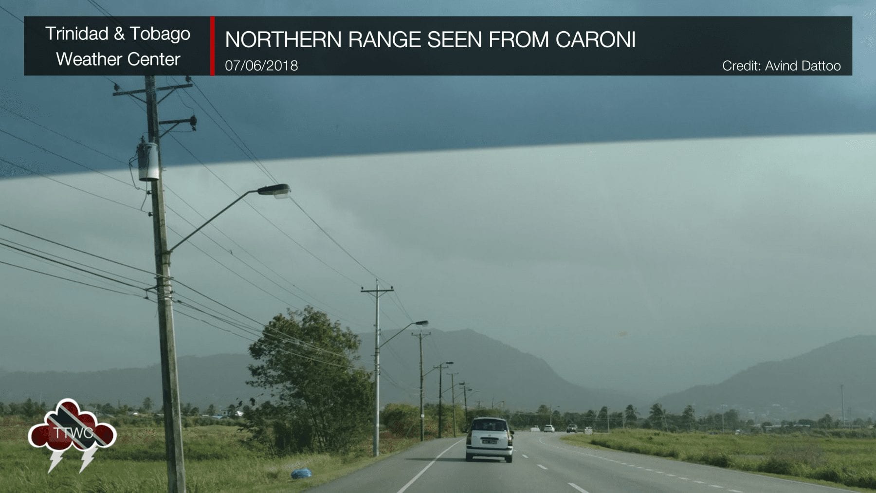
Several times a year, Saharan dust moves across our region, turning our typically blue skies into a dusty, hazy mess. The Sahara Desert emits more particles than any other desert in the world. More than half of the dust deposited in the oceans originates in North Africa. This Saharan dust affects the climate: among other things, it blocks or reflects sunlight and influences the formation of clouds and hurricanes. It becomes a time of sniffles and coughs for those with respiratory ailments, as the dusty atmosphere affects day-to-day life. However, Saharan dust isn’t all bad, as it provides nutrients for the world’s largest oxygen producers – phytoplankton in the Atlantic Ocean and the Amazon rainforest.
Saharan Dust Causes
There are two leading causes of Saharan dust transport, depending on the time of year. Harmattan winds bring mild to moderate outbreaks across Trinidad and Tobago from November to the middle of March.
Thunderstorms across Central and Western Africa bring mild to severe outbreaks to Trinidad and Tobago between April and November, with peak activity from June through August.
Harmattan Winds
The Harmattan is a season in West Africa that occurs between the end of November and the middle of March. During this season, a predominant northeasterly trade wind (dubbed the Harmattan Winds) blows from the Sahara Desert over Western Africa into the Gulf of Guinea.
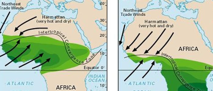
During this period, a ridge of high pressure stays over the central Sahara Desert, and the Intertropical Convergence Zone (ITCZ) remains over the Gulf of Guinea. The Harmattan wind accelerates when it blows across the mountain massifs of Northwest Africa. If its speed is high enough and blows over dust source regions, it lifts the dust and disperses it. Dust that reaches the upper levels of the atmosphere can then be transported across the Atlantic Ocean and affect the Eastern Caribbean. These Saharan Dust outbreaks tend to be milder in the Eastern Caribbean than those associated with West African thunderstorms, which drive dust into the upper atmosphere from April through November.
Thunderstorms Across Central Africa
Typically running from April through November, strong thunderstorms begin to develop across interior Central Africa and progress westward. These thunderstorms are due to the dry northeasterly trades meeting the moist summer monsoon.
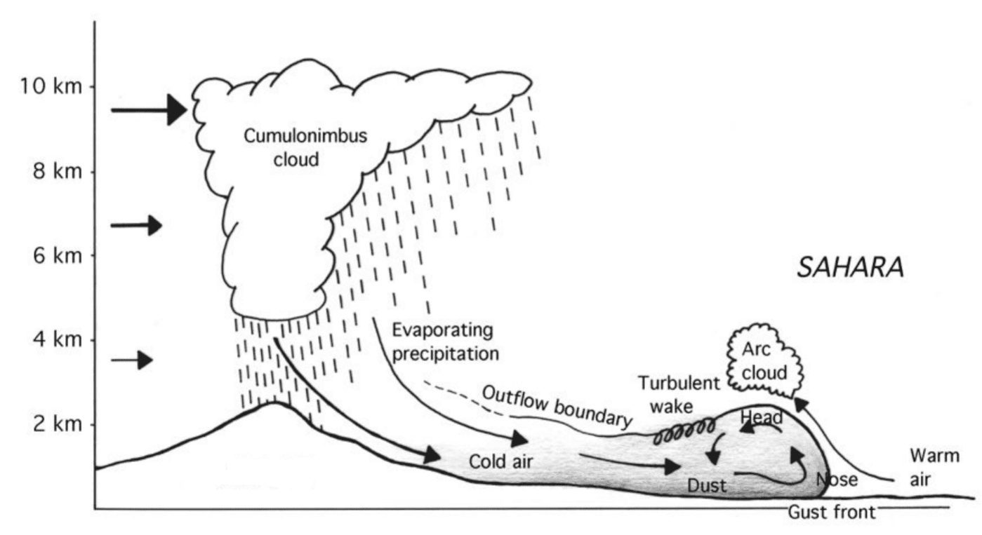
As strong winds move downward and outward from these thunderstorms, it kicks up dust as they cross parts of the Saharan Desert and transport particles into the upper atmosphere. This dust then moves across the Atlantic Ocean and affects the Caribbean, parts of Central America, and the Southern United States.
The emission and dispersion of dust are not limited to the two above causes. Still, they can be affected by several meteorological phenomena: El Niño, the North Atlantic Oscillation, rainfall in the Sahel, the Sahara Heat Low, and the Intertropical Convergence Zone.
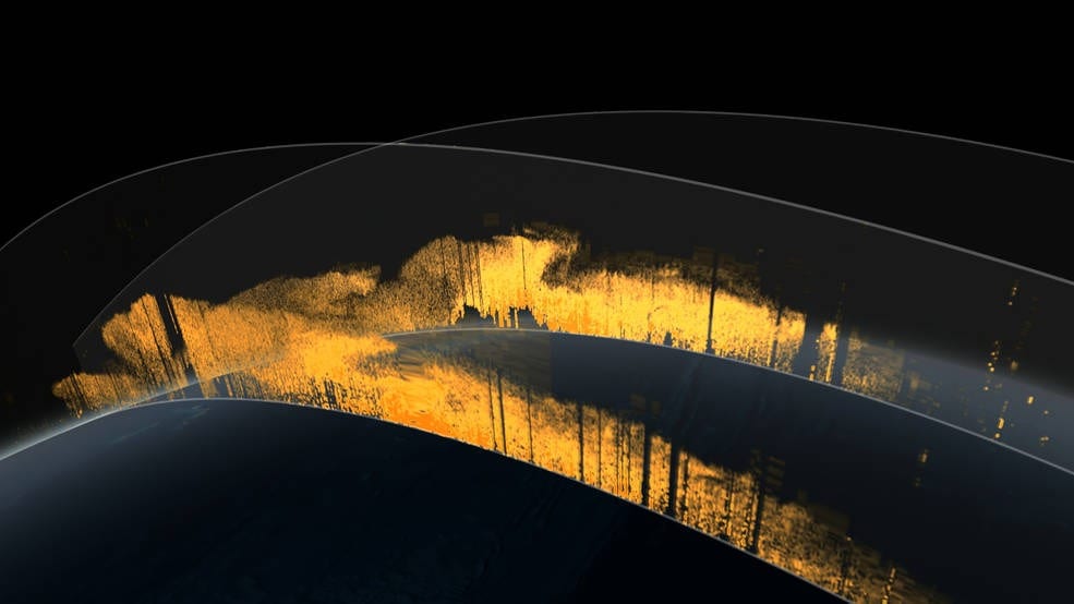
The Saharan Air Layer
The dust band is fed by strong, low- to mid-level easterly winds that lift sand and dust particles into the atmosphere, generating the infamous annual dust haze.
Saharan Air Layer (SAL) is an extremely hot, dry, and dust-laden layer of air originating over North Africa’s Sahara Desert, extending upwards from the surface for several kilometers.
Dusty, very dry, and warm, this layer of air is pushed westward by easterly winds or thunderstorms (see above). On reaching the West African coast or the Eastern Atlantic Ocean, it rides over the cooler, more moist surface air of the Atlantic Ocean. This forms an atmospheric inversion layer or boundary with warm, dry air aloft and cooler, moist air below.
When the SAL reaches the Atlantic Ocean, easterly trade winds carry the dust across the lower and mid levels, some of which, sometimes at high concentrations, are deposited over Trinidad and Tobago and the Southern Caribbean.
Saharan Dust Days Increasing Across Trinidad and Tobago
Many complain that Saharan Dust is a new phenomenon. Unfortunately, this dusty misery has existed as long as the Sahara Desert, and it is a vital source of nutrients for the Amazon Rainforest.
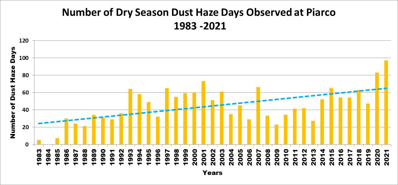
However, recent data from the Trinidad and Tobago Meteorological Service suggests that dust events have become markedly more frequent. In the 1980s, Saharan Dust was present for 25 to 35 days during the five- to six-month span of the Dry Season. By 2020, this average increased to over 60 days during the same five to six-month Dry Season span.
One study, published in November 2019 in the journal JGR: Atmospheres, suggests more dust has been transported out of the Sahara in the last 100 years than in centuries past. The study also suggests that drought periods in North Africa, especially in the Sahel region south of the Sahara, are associated with stronger dust events. If these droughts happen more frequently in the future, scientists might expect Saharan dust events to intensify. But it’s not clear whether that will be the case.
Whether we’ll see more or less Saharan Dust in the coming years is far from certain. Using a combination of satellite data and computer models, NASA brings better news. They predict that Africa’s annual dust plumes will actually shrink to a 20,000-year minimum over the next century due to climate change and ocean warming. Recent NASA research outlines the domino-like connections between factors beyond the desert’s borders and the development of dust plumes. These start with temperature differences between the North and South Atlantic, which influence the region’s consistent east-to-west winds and a tropical band of relatively high rainfall near the Equator, both of which shape the annual dust plumes.
Research has also linked Saharan dust plumes to other natural climate variables, such as El Niño events. Some of these climate variables may also change as the world continues to warm, a process scientists are still investigating.
So, for now, the future of Saharan dust plumes remains unclear. What remains unchanged is the impact of our dusty future on the air quality across Trinidad and Tobago, so you should pay closer attention to Saharan Dust forecasts and learn what you can do to protect yourself.
Saharan Dust Monitoring & Forecasting
Saharan Dust is monitored and forecast through satellite imagery and numerical weather models. There are several dust models, including NASA GEOS-5, the University of Athens SKIRON Model, and the ECMWF’s Copernicus Atmosphere Monitoring Service (CAMS), to name a few.
These models model the aerosol optical thickness or the actual dust concentration within an atmospheric column or near the surface. The aerosol can be sea salt, dust, soot, and sulfates, but it looks at dust in this case. Aerosols absorb or reflect energy (light), influencing temperatures in the atmosphere and on the ground. Satellites measure aerosols by how much light they allow to pass through. A thick layer of aerosols blocks the ground from view, while a thin layer allows enough light through to see it. The measurement is called aerosol optical thickness. These models can also use aerosol optical depth, which is the degree to which aerosols reduce light transmission through absorption or scattering.
False-colored visible satellite imagery is also a useful tool to visualize Saharan dust as it is transported across the Atlantic Ocean. The dust particles in the atmosphere appear tan to brown.

Lastly, the Cooperative Institute for Meteorological Satellite Studies’ (CIMSS) Saharan Air Layer Analysis is another product that can be used to determine and track Saharan Air across the Atlantic Basin.
Saharan Dust Effects
Health. High concentrations of dust with a diameter of less than 2.5 micrometers (PM2.5) have been associated with increased emergency room admissions for respiratory and cardiovascular disease in North America, Asia, and Europe. The primary health concern associated with Saharan dust is particulate matter, microscopic dust (PM2.5 & PM10), which can sidestep the lungs’ natural defenses. These tiny particles can contribute to cardiovascular problems and respiratory diseases, such as asthma, especially in children and the elderly.
The dust particles also serve as vehicles for the transport of known asthma triggers, including biological materials such as bacteria, viruses, fungal spores, and pollen. It has also been shown to transport various pollutants, including metals and pesticides. Dry skin and cracked lips are also typical symptoms of dense Saharan dust.
Visibility. Dust in our atmosphere ultimately causes hazy skies. Depending on the concentration, these hazy skies can significantly reduce visibility at airports, on the roadways, and on shipping lanes.
Weather. Saharan dust has several implications for the weather.
- Sunlight & Temperatures. The dust can reflect or block sunlight, resulting in lower-than-usual surface temperatures. However, this effect is only observed when concentrations are very unhealthy to hazardous.
- Formation of Clouds & Tropical Systems. It can also affect cloud formation, as the layer of air through which Saharan dust is transported across the Atlantic is quite dry, suppressing cloud development. This dry air layer (the Saharan Air Layer) also suppresses the development of tropical cyclones. While this may sound like a benefit, tropical cyclones are necessary for transferring heat from the oceans to the atmosphere. Without tropical cyclones, ocean temperatures will increase, coral bleaching will occur, and predominant ocean currents will be impacted, with many knock-on effects. Additionally, tropical cyclones can contribute significant rainfall to areas with limited freshwater access.
- Locally Severe Showers & Storms. While having moist air at all levels of the atmosphere may seem beneficial for showers and thunderstorms, drier air at upper levels can contribute to stronger thunderstorm development and wind gusts. As the Saharan Air Layer is a well-mixed layer of dry air between 5,000 ft and 15,000 ft, it provides conditions favorable for higher instability and convective wind gusts at the surface in strong thunderstorms. You can read more about this here.
- Sunsets. With increased dust in the atmosphere, light scatters more at sunset. This allows for more colorful sunsets.
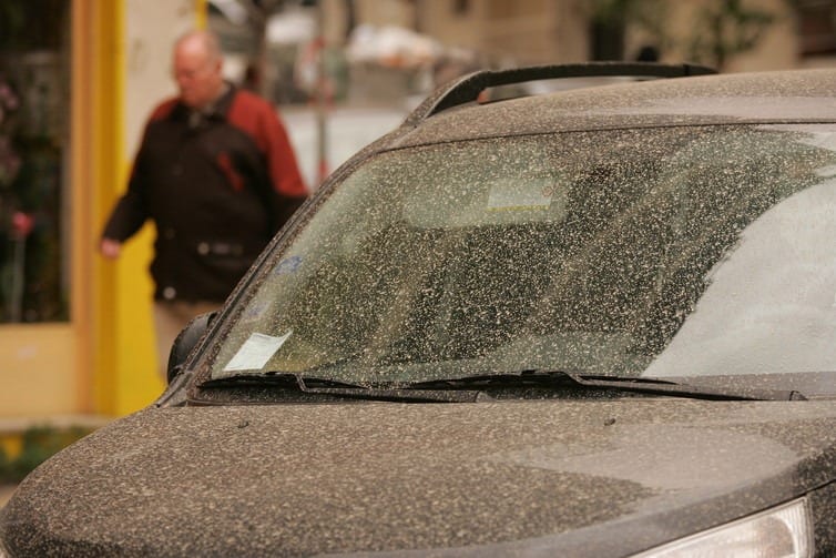
- Muddy Rainfall. While not as extreme as it sounds, vehicle owners who just washed their cars before rainfall during a Saharan Dust outbreak would notice this more than anyone. The dust mixes with the rainfall, and when it lands on the surface, it becomes a layer of dust and mud when the dust is particularly thick.
Geobiological.
- The Amazon Rainforest. Approximately 400 to 700 million tons of dust are transported from the Sahara annually. This dust plays a crucial role in replenishing nutrients that are usually leached by rainfall in the Amazon Rainforest. Research has shown that this dust is rich in phosphorus, which is the main nutrient source for the Amazon.
- Plankton. Saharan dust is also a significant contributor of iron to marine algae. As nutrient levels increase, the algae sink to the ocean floor or are eaten by planktonic organisms. Carbon dioxide can be sequestered into the seafloor sediments by planktonic organisms with sinking carbonate shells. The distribution of iron in the oceans is likely to help trap excess atmospheric carbon dioxide. On the one hand, global warming could increase winds and therefore dust production. However, more dust could enter the ocean, potentially serving as a natural mitigator of those effects. Phytoplankton in the Caribbean and along the southeastern U.S. coast feed on this iron as well. It allows these organisms to thrive and produce substantial amounts of oxygen.
- Bacteria Blooms. Notably, 12 different species of pathogenic bacteria from the genus Vibrio use these nutrient infusions to create blooms of their own. Marine Vibrio species also play a role in many diseases of ocean organisms. There are more Vibrio in the water when it’s warmer. Filter-feeding shellfish accumulate Vibrio parahaemolyticus and Vibrio vulnificus in their meat. This causes the majority of seafood-related illnesses and deaths in the U.S. Other Vibrio species are known to be associated with diseased coral that is already facing many other environmental stressors. Vibrio disease and mortality have even placed an economic strain on the fishing and shrimp farming industries.

