


What you need to know
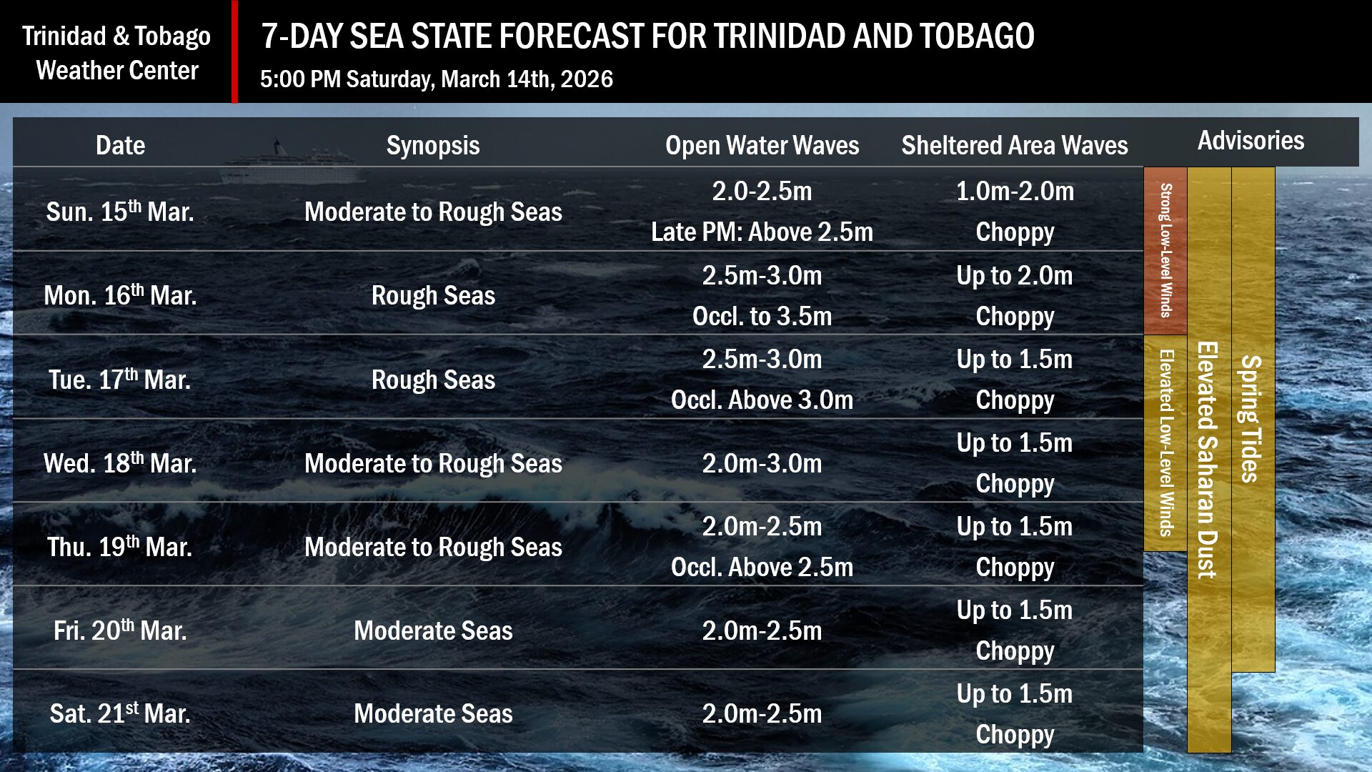
— What: A strong low-pressure system in the North Atlantic Ocean is building across the Lesser Antilles this weekend, forecast to produce strong surface to low-level winds and moderate to rough seas around the islands from Sunday. Peak wave heights are forecast between 3.0 meters and 3.5 meters with peak winds near 25 knots and gusts near 30 knots. Swell periods are forecast to remain below 11 seconds.
— Where: While the entire marine area is affected, open-water seas, particularly northern and eastern exposed coastlines and seas, will experience agitated seas and larger waves along those coastlines.
— When: Peak winds and waves are forecast on Monday and are set to marginally diminish as the week progresses. A Hazardous Seas Alert is in effect through noon Thursday, March 19th.
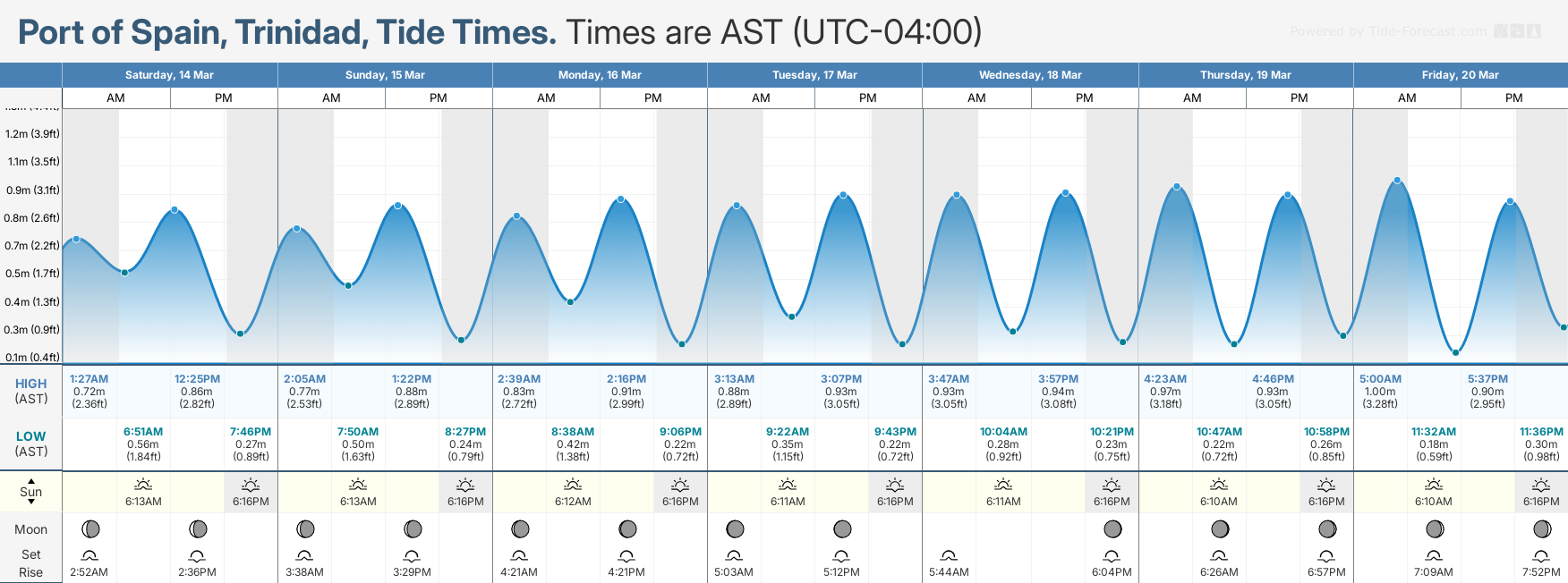
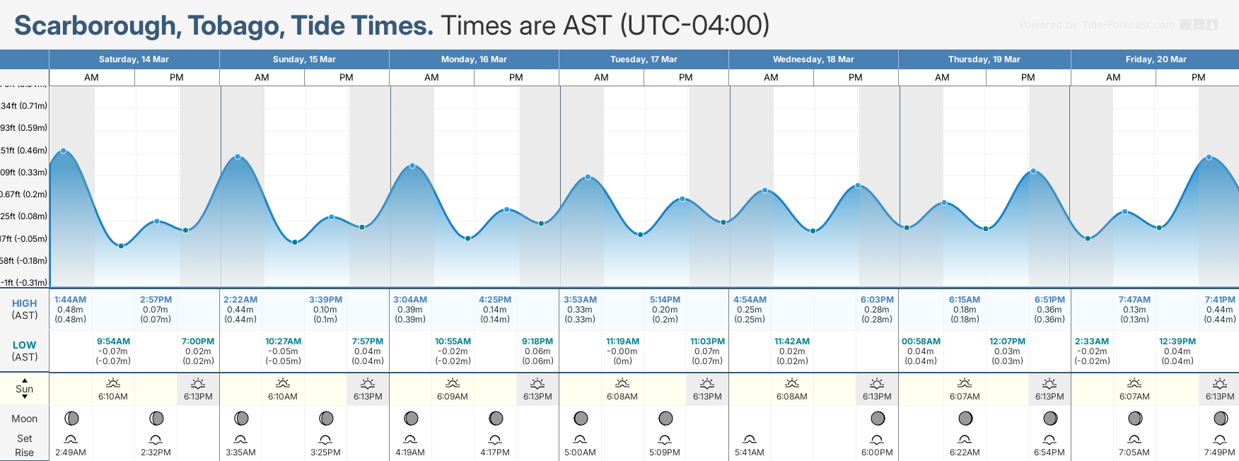
— Impacts: Agitated seas are likely to be particularly perilous for offshore activities. This includes fishing and other small craft marine interests. There is also an increased risk of strong rip currents, posing a serious hazard to swimmers and beachgoers. Rip currents can be life-threatening even for experienced swimmers. Some beach erosion is inevitable, with certain eastern and northern beaches becoming submerged during spring tides, particularly at high tide.
— What Should You Do: All marine interests need to exercise extreme caution. Inexperienced mariners should avoid navigating in hazardous conditions, especially those operating smaller vessels. If you intend to go into the water at beaches, it is recommended that you use beaches with on-duty lifeguards. Particularly on Sunday through Monday, secure loose and light outdoor objects, particularly along the northern and eastern coasts.
Latest Alerts

Localized Flood Alert Discontinued For Trinidad
Trinidad and Tobago is NOT under any tropical storm or hurricane threat, watch, or warning at this time.
Seas Forecast For Trinidad and Tobago
What should you do
All marine interests should practice common-sense safety. Small craft operators should seek safe harbor during heavy showers and thunderstorms. Inexperienced mariners, especially those operating smaller vessels, should avoid navigating in hazardous conditions. Inexperienced swimmers, if intending to go into the water, should use beaches with lifeguards on duty.
Secure coastal property and objects on the beachfront that the wave action or winds may sweep away, particularly on March 15th and 16th, when elevated winds are forecast due to a strong pressure gradient across the area.
Saharan Dust concentrations are forecast to be elevated across Trinidad and Tobago, reducing horizontal visibility. Particularly during dawn and dusk, and when winds are elevated, small craft operators should exercise enhanced caution.
Elevated winds will lead to choppy seas in the Gulf of Paria and larger-than-usual waves. Mariners should generally exercise caution during heavy showers or thunderstorms, as seas may become locally rough or choppy in their vicinity, particularly due to gusty winds.
Rip currents always pose a hazard on the nation’s beaches. If caught in a rip current, swim perpendicular to the current, parallel to the shore.


