Trinidad and Tobago’s 2026 Dry Season is forecast to bring usual overall rainfall totals, front-loaded by wetter-than-normal conditions in the first half of the season, according to the Trinidad and Tobago Meteorological Service (TTMS).
Rainfall Outlook For January-March 2026

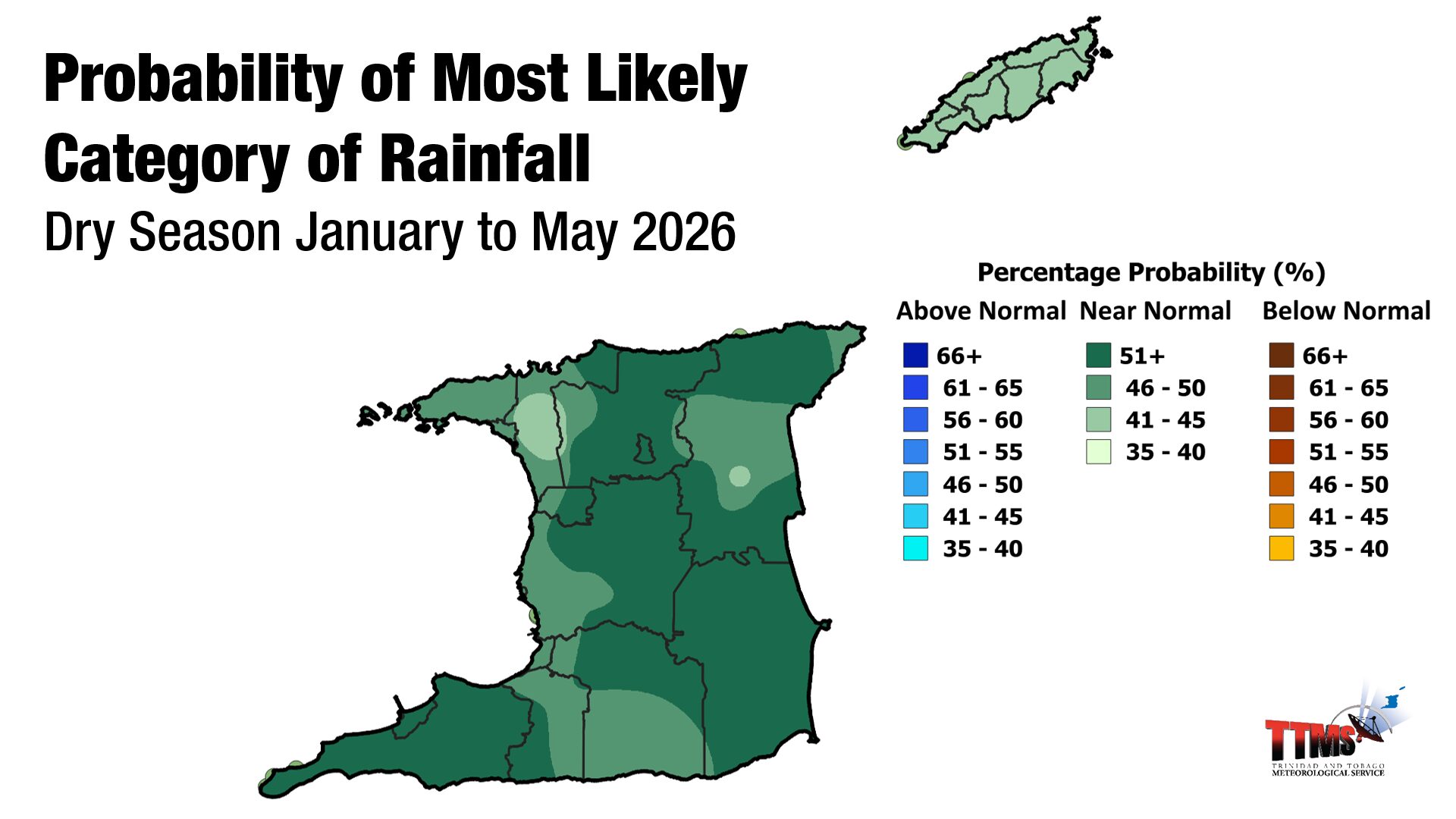
According to the TTMS, the January–March (JFM) 2026 period has a moderate to high probability (around 56–76%) of above-normal rainfall over most of Trinidad and Tobago, with much of that excess falling in January and early March.
Northern and eastern Trinidad (e.g., Valencia, North Oropouche, Sangre Grande) and central Tobago (e.g., Roxborough, Glamorgan) are favoured for the highest accumulated totals, according to the TTMS’ outlook.
Above-normal rainfall is defined as totals at or above 125% of the 1991–2020 long-term average.
Rainfall Outlook For March-May 2026

As the 2026 Dry Season progresses, the TTMS is forecasting near-normal rainfall between March and May. March and April are the two driest months of the year for T&T. Near normal is defined as rainfall amounts within the range 75% to 125% of the Long Term Average (1991-2020).
Overall Rainfall Outlook For The 2026 Dry Season
The 2026 Dry Season (January–May) shows a strong signal favouring near-normal rainfall across most of Trinidad and Tobago, defined as rainfall within the range 75% to 125% of the Long Term Average (1991-2020).
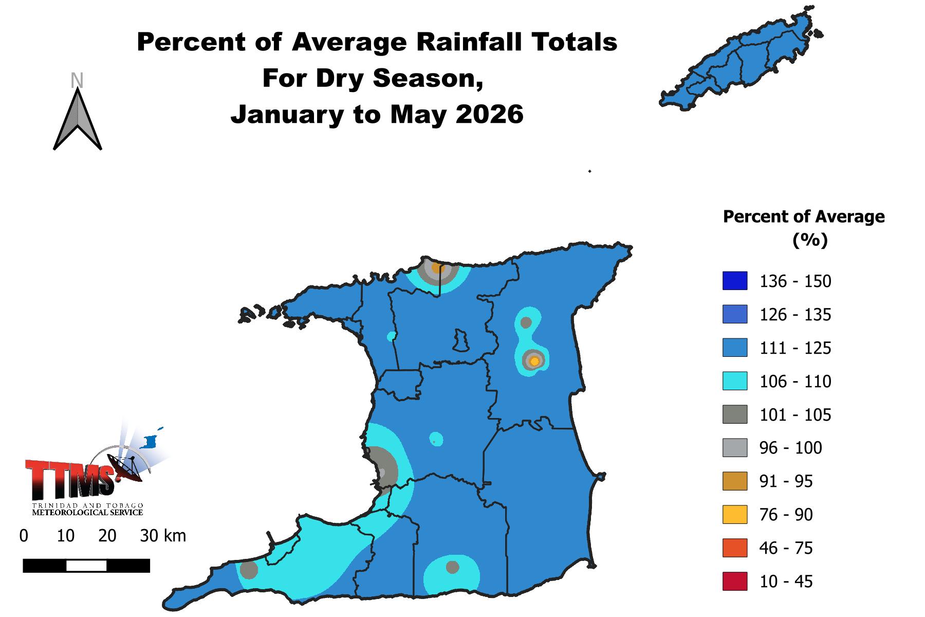
In general, the dry season is likely to receive 84% and 124% of the average rainfall, according to the TTMS. The country is likely to experience about 97 dry days (rainfall less than 1.0 mm), fewer than the average of 108 dry days.
Historically, the Dry Season sees 3–8 seven-day dry spells and 1–5 ten-day dry spells; for 2026, there is about a 57% probability of five seven-day dry spells and a 53% probability of three ten-day dry spells.
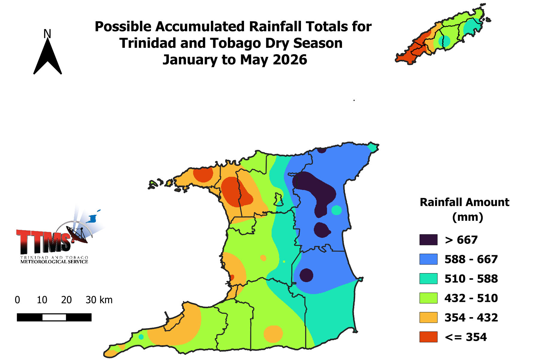
Highest seasonal totals (roughly 540–769 mm) are favoured over northern and eastern Trinidad (Valencia, North Oropouche, Sangre Grande) and northeastern/central Tobago (Charlotteville, Speyside, Roxborough, Glamorgan).
Lowest totals (around 266–400 mm range) are expected in northwestern Trinidad (St. Joseph, San Juan, Port of Spain, Diego Martin, Claxton Bay) and southwestern Tobago (Scarborough, Mason Hall, Crown Point, Plymouth).
When considering the chance of a severe drought, where overall rainfall totals are in the lowest 10% of all dry season rainfall totals, the TTMS gives the 2026 Dry Season a low to moderate chance (3-15%).
Conversely, their outlook indicates moderate to high probability (18%-89%) that the national average of 412 mm will be surpassed. Areas in eastern Trinidad and central Tobago have the highest probability of exceeding the national average, while small areas in northwest Trinidad and southwest Tobago have the lowest probability of exceeding it.
What’s influencing T&T’s Dry Season Weather?
Firstly, a shift from ENSO neutral to weak La Niña conditions occurred in October 2025. Weak La Niña conditions will favor rainfall over Trinidad and Tobago during the first half of the Dry season.
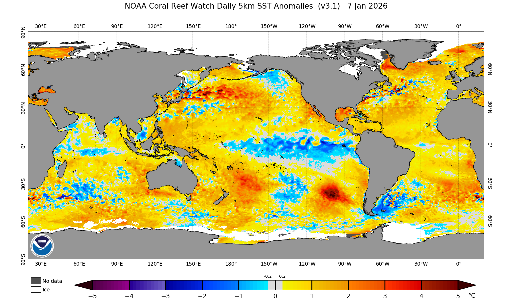
Sea surface temperatures (SSTs) in waters near Trinidad and Tobago, further east and southeast into the Atlantic Ocean, are above-average for this time of the year and are forecast to continue into the dry season of 2026. These above-average temperatures provide elevated moisture that fuels passing showers (low-level cloud patches).
During the last quarter of 2025, the North Atlantic Oscillation (NAO) was generally negative and is forecast to maintain a similar pattern. A negative-to-neutral NAO generally produces weak to average wind speeds across Trinidad and Tobago. According to the TTMS, there is a moderate probability (60%) of February having higher wind speeds, which may reduce rainfall amounts. The latest medium-range forecast models support TTMS’ analysis.
Lastly, the Madden-Julian Oscillation (MJO) is forecast to return to the Western Hemisphere, including the Caribbean Basin, by the end of January into early February. The MJO, when present, enhances overall rainfall.
What does this mean for you?
The wetter start, combined with December 2025 rainfall, supports reservoir, river, and groundwater recharge, benefiting water resources during the later Dry Season months.
Reduced fire potential is likely early in the season, with bush, forest, and landfill fire risk increasing as conditions become drier and more typical later in the season.
However, more frequent rainfall early in the season may create favorable conditions for agricultural pests and diseases, as well as vector-borne diseases such as gastroenteritis and leptospirosis.
With drier conditions forecast later in the dry season, households should conserve, store, and manage water safely and adequately.