The 2026 wet season has arrived early, but it is unlikely to be a generous one. The Trinidad and Tobago Meteorological Service (TTMS) expects rainfall across the islands to be near or below normal for the season as a whole and is urging the public to conserve water over the coming months. Crucially, a drier-than-usual wet season does not mean a quiet one: the potential for heavy downpours and localized flooding remains, and seasonal flood potential is rated normal to moderate.
Here is what the outlook says, how Trinidad and Tobago differ, and what it means for the months from June through November.
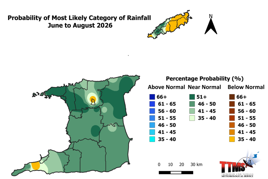
Near-Normal Rains For Trinidad; Below-Normal For Tobago
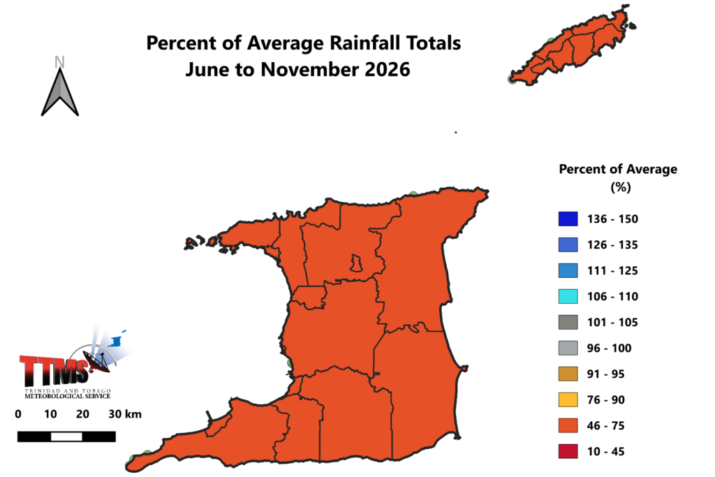
After a notably early start to the wet season in May, TTMS expects near-normal rainfall for Trinidad and below-normal rainfall for Tobago over the coming wet season. Across the wider June-to-November period, most of the country is forecast to receive only 62-70 percent of its long-term (1991–2020) average rainfall, with the wettest areas still topping out at around 71 percent of average.
In short: the taps from the sky will run, but more sparingly than usual. TTMS has paired the outlook with a direct call to conserve water for the 2026 wet season.
Despite the lower totals, seasonal flood potential remains normal to moderate — a reminder that even a below-average season can deliver damaging rainfall on any given day.
Read More
2026 Wet Season: Which Communities Have The Highest Flood Risk?
Trinidad and Tobago: a tale of two islands
The two islands are not on the same footing this Wet Season.
Trinidad is expected to see the first half of the wet season (June–July–August) play out mostly wet, as usual, helped by a moderate chance that the Intertropical Convergence Zone and moist southeasterly flow will visit the island more frequently than Tobago.
Tobago, by contrast, is forecast to be mostly drier than usual through the first half of the wet season, reinforcing the below-normal signal for the sister isle.
When it comes to expected seasonal accumulations, TTMS projects:
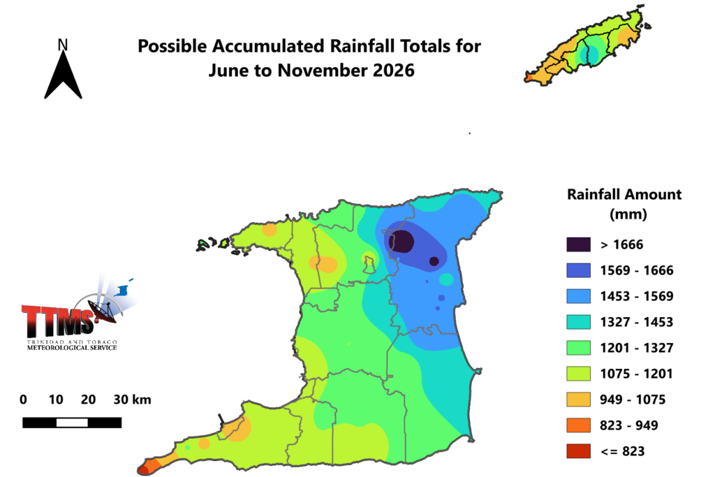
- Trinidad: rainfall volumes between roughly 672 mm and 1,848 mm for the wet season, with the highest totals concentrated in eastern and northeastern Trinidad — in the vicinity of Cumaca, Sangre Grande, Vega de Oropouche, Plum Mitan and surrounding areas.
- Tobago: rainfall volumes between roughly 920 mm and 1,435 mm, with the maximum over Mount St. George, Goodwood and environs.
How the wet season unfolds, month by month
The rolling three-month outlooks paint a consistent picture of a restrained wet season:
- June–July–August (JJA): mostly wet as usual in Trinidad; mostly drier than usual in Tobago.
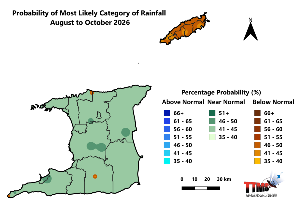
- July–September (JAS) and August–October (ASO): near-normal to below-normal rainfall totals.
- September–November (SON): a moderate probability (in the 20–52 percent range) that totals will finish below normal.
The signal, in other words, leans drier as the wet season matures.
Wet days and wet spells: fewer, and less intense
Regional guidance from the Caribbean Institute for Meteorology and Hydrology (CIMH), through the Caribbean Climate Outlook Forum (CARICOF), aligns with the TTMS picture. Across the Lesser Antilles, fewer wet days than usual are forecast for June through August (medium-to-high confidence), along with fewer wet spells and very wet spells than normal.
For Trinidad and Tobago specifically, there is a 70–100 percent chance of fewer wet days during June through August, and roughly a 50–59 percent chance of below-normal 7-day wet spells.
The station-level numbers tell the story:
| Indicator (Jun–Aug) | Trinidad (Piarco) climatology | Trinidad forecast | Tobago (Crown Point) climatology | Tobago forecast |
|---|---|---|---|---|
| Number of wet days | 51–61 | 46–57 | 39–49 | 48–48 |
| 7-day wet spells (top 20% wettest days) | 4–8 | 4–8 | 3–7 | 3–7 |
| 7-day very wet spells (top 10% wettest days) | 2–5 | 4–4 | 1–4 | 1–4 |
TTMS also expects fewer multi-day soakings: there is a 46 percent chance of a below-normal number of 3-day wet spells (the country normally sees about five 3-day spells of 10 mm or more across the season), and a 52 percent chance of below-normal 5-day wet spells — with just one 5-day spell likely, down from a usual average of two.
Dry spells: watch Tobago
With a drier wet season comes a higher likelihood of dry stretches, and here, Tobago again stands apart.
Historically (1991–2020), Trinidad averages one 7-day dry spell between June and August and typically sees no 10-day or 15-day dry spells. Tobago is drier by nature, averaging two 7-day dry spells, one 10-day spell and one 15-day spell over the same window.
For 2026:
- Trinidad: a 10 percent chance of three or more 7-day dry spells, with the most likely maximum being just one.
- Tobago: a 20 percent chance of three or more 7-day dry spells (maximum of two), plus a 10 percent chance of at least one 15-day dry spell.
The risk of heavy rainfall has not gone away
This is the most important nuance of the wet season. A near-to-below-normal outlook describes the total — it does not rule out intense, localized downpours that cause flash flooding.
In fact, the flash-flood signal is high according to the CIMH’s CARICOF Flash Flood Potential Outlook. There is an extremely high probability (greater than 80 percent) of excessive rainfall – defined as more than 30 mm in 24 hours – for Trinidad, and a high probability (50–80 percent) for Tobago over the first half of the wet season. Trinidad typically records about five such excessive-rainfall days between June and August, and Tobago about three; for 2026, the forecast is four to five for Trinidad and four for Tobago. June alone, which usually sees about one such day, carries a high (50–80 percent) potential for excessive rainfall on both islands.
The bigger rainfall days are also forecast to be fewer across the season as a whole. These figures come from the TTMS over the full June-to-December season and use its own thresholds, rather than the CIMH flash-flood measure cited above, which covers June to August. For June to December, TTMS sees a 55 percent chance of a below-normal number of heavy rainfall days – days on which more than 25 mm falls – with 6 to 10 such days likely, against a 1991–2020 average of 16. The most intense days follow the same pattern: a 60 percent chance of below-normal extremely heavy rainfall days (more than 50 mm), with 1 to 3 likely rather than the usual 4, and only about 1 day expected to exceed 75 mm.
That distinction matters for the kind of flooding to expect. Isolated heavy or extremely heavy rainfall days can be disruptive in the moment, flooding streets and low-lying spots for a few hours, but the longer-lasting riverine flooding that affects whole communities generally requires rainfall to persist over several days. Here the season leans favorable: alongside the fewer 5-day spells already noted, only about four 3-day wet spells (reaching or exceeding 10 mm) are likely this season, against a usual five, so the sustained, multi-day soakings that drive river flooding should be less frequent than normal.
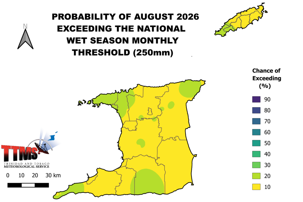
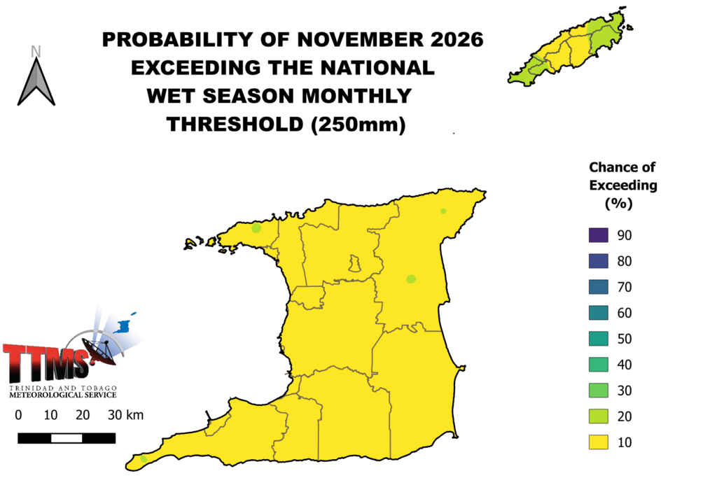
The larger thresholds remain unlikely, but not impossible. The chance of any single month reaching the national wet-season threshold of 250 mm is low: for August 2026, TTMS puts it at 3–16 percent in Trinidad and 8–15 percent in Tobago, and for November at just 2–15 percent across northeastern Trinidad and all of Tobago.
CARICOF guidance adds that flood potential across the islands is expected to climb from moderate in June and July to high in August, the period to watch most closely.
Where flooding is most likely
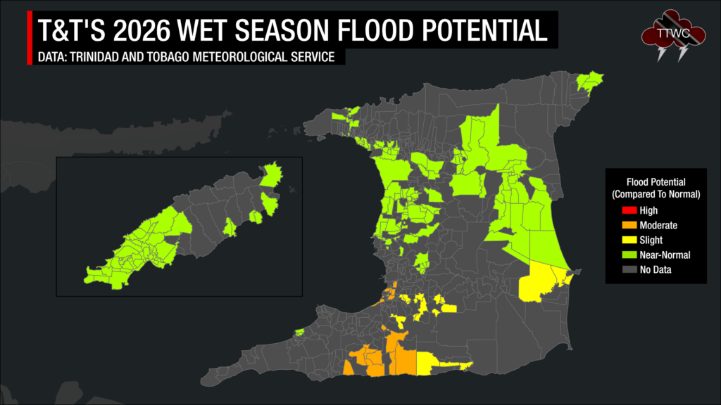
TTMS’s Wet Season Flood Risk Potential Outlook rates most of the country at near-normal potential, including:
- Trinidad: central and northern areas — St Helena, Piarco, Tunapuna, Port of Spain, Diego Martin, Plum Mitan, Arima, La Horquetta, Sangre Grande and parts of Manzanilla.
- Tobago: Scarborough, Crown Point and environs.
Elevated flood potential, however, is flagged for San Fernando, the South Oropouche River Basin, Penal, Debe, Siparia, Moruga and surrounding communities — the southwestern and southern low-lying areas that should plan ahead.
And drought?
The good news: based on CIMH analyses, there are no concerns about widespread short-term drought through the end of November 2026 for Trinidad and Tobago. The bigger drought question lies beyond the wet season and into the next dry season, given the climate drivers at play.
What is driving the outlook
Several large-scale signals point toward a drier season:
- ENSO/El Niño: The tropical Pacific is currently ENSO-neutral, but there is an 80 percent or greater probability of El Niño developing by the end of June 2026, according to the TTMS. El Niño tends to stabilize the atmosphere over the Caribbean, promoting sinking air, suppressing deep convection, and increasing wind shear, all of which favor rainfall deficits during June through September, with deficits often persisting into the following winter.
- Atlantic Meridional Mode (AMM): A key driver of local rainfall, the AMM is currently in a negative mode, working against wet-season rainfall, before a likely transition to neutral by August–October.
- Sea surface temperatures: Waters east of the islands and out toward West Africa (the Atlantic Main Development Region) are running normal to slightly above normal, with patches of warmth along the central tropical Atlantic.
- ITCZ and moisture flow: A moderate (65 percent) probability that the Intertropical Convergence Zone, cloud-convergence bands and moist southeasterly flow will visit frequently — favoring Trinidad more than Tobago.
- NAO and MJO: The North Atlantic Oscillation, weakly negative in May and forecast to turn weakly positive in June, exerts a small negative influence on rainfall. The Madden-Julian Oscillation is incoherent at present, with only a low chance of rainfall-enhancing Kelvin or Rossby wave activity in May/June.
What does this mean for you?
Water management. This is the wet season’s central message. With totals running well below average and recharge rates rising only slowly, reservoirs, surface flows, and river levels will fill gradually. Conserve water now and continue water-saving practices through the season. Authorities are urged to desilt rivers, channels, outlets and reservoirs, and to construct or clear retention ponds.
Agriculture and food security. Regular rainfall will still serve crops, but the excess on heavy-rain days can waterlog fields and damage younger plantings. Farmers should revisit flood-action plans and stay alert to pest and disease pressures.
Health. Surface-water ponding after heavy rain promotes mosquito breeding and raises the risk of vector-borne diseases. Heavy-rain days can also increase turbidity and degrade water quality. The health sector is advised to revisit contingency plans for spikes in vector-borne illness and to review fumigation programmes.
Drainage and infrastructure. With flood potential climbing into August, the period for de-silting and clearing drainage systems, water channels and river mouths is now. Watch for rockfalls that may signal future landslides.
The general public and disaster managers. Residents in flood-prone areas, particularly across southern and southwestern Trinidad, should quicken their preparedness: assemble emergency supplies and a grab-and-go bag, identify shelter locations, become sandbag-ready, and develop a family and pet evacuation plan. Disaster management agencies should review contingency plans and early warning channels ahead of August.
The bottom line
The 2026 Wet Season opens early but modest. Expect near-normal rainfall in Trinidad and below-normal in Tobago, totals running 62–70 percent of average, fewer wet days and wet spells, and a drier tilt as the season deepens into the autumn. Yet the season’s biggest watch-point is not how much rain falls overall — it is the handful of intense days that can still bring flash flooding, especially around August, and especially across southern Trinidad. Conserve water, prepare for the heavy days, and keep an eye on the daily forecasts alongside this seasonal picture.
Sources: Trinidad and Tobago Meteorological Service’s Rainfall and Temperature Outlook for the Wet Season 2026; Caribbean Institute for Meteorology and Hydrology Caribbean Climate Outlook Forum’s Wet Days and Wet Spells Outlooks (June–August 2026) and supplementary CIMH flash flood, dry-spell and drought guidance.
Compilation: Trinidad and Tobago Weather Center.