The Trinidad and Tobago Meteorological Service (TTMS) is forecasting a below-average to near-normal 2026 Atlantic Hurricane Season for Trinidad and Tobago, based on the number of tropical cyclones that develop east of T&T. While systems may form within the TTMS area of interest, it only takes one storm to directly impact the country for it to be an active hurricane season.
What you need to know
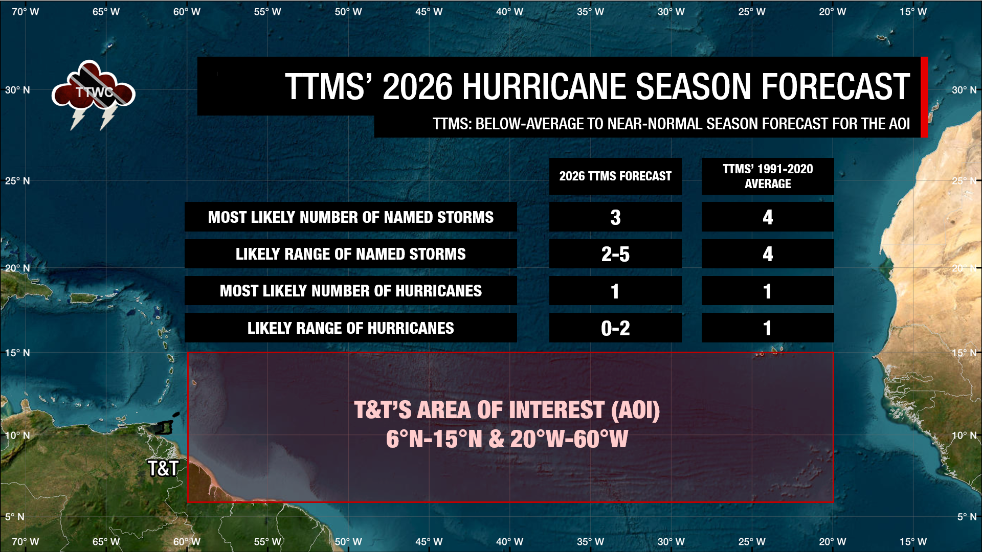
— The Forecast: Between the eastern Caribbean and the west coast of Africa, south of 15°N, the TTMS is forecasting between two and five named storms, with three named storms most likely forming and up to two of those named storms becoming a hurricane, with one hurricane most likely.
— How confident are they? The TTMS has a 37% chance of below-normal, a 36% chance of near-normal, and a 27% chance of above-normal tropical storm activity.
— What should you do? Any tropical cyclone that forms in the area of interest has the potential to threaten Trinidad and Tobago and the remainder of the Eastern Caribbean. A season only needs one tropical cyclone to cause devastation in T&T and the remainder of the region. Citizens are advised to increase preparation ahead of the 2026 Atlantic Hurricane Season’s peak.
The Forecast Background
Since 2013, the Trinidad and Tobago Meteorological Service has been issuing seasonal forecasts for Trinidad and Tobago’s area of interest (AOI) for tropical cyclone activity. However, these forecasts have only been issued to the public since 2016.
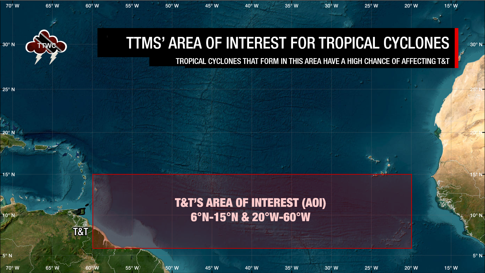
The Met Office has defined T&T’s AOI as south of 15°N latitude to 6°N, between the eastern Caribbean and the west coast of Africa, within the north Atlantic Ocean between 20°W and 60°W. According to the Met Office, only tropical cyclones forming in this area have been known to directly threaten Trinidad and Tobago.
The North Atlantic Hurricane Season officially runs between June 1st and November 30th, but out-of-season systems have formed in the past, like in January 2023.
Based on the 1991-2020 climatological average, 3.6 (rounded up to 4) named storms formed in this area, one (rounded down from 1.1) of which generally became a hurricane.
The 2026 Hurricane Season Forecast For T&T
According to the Trinidad and Tobago Meteorological Service, there is a 37% chance of below-normal, a 36% chance of near-normal, and a 27% chance of above-normal tropical storm activity in the area of interest for T&T.
The TTMS predicts that the most likely number of named tropical storms (tropical cyclones with winds of at least 34 knots, 39 MPH, or 63 KM/H) to occur within the AOI from June through November is 3.
The most likely number of hurricanes (tropical cyclones with winds of at least 64 knots, 74 MPH, or 119 KM/H) predicted to occur within the AOI from June through November is 1. The TTMS says there is a 49% chance of below-normal, a 36% chance of near-normal, and a 15% chance of above-normal tropical storm activity in the area of interest for T&T.
Looking at the 2026 Hurricane Season overall, the United States’ National Oceanic and Atmospheric Administration’s National Weather Service released its annual hurricane forecast, which called for below-normal activity due to El Niño.
How does the forecast work?
According to the TTMS, the seasonal tropical cyclone predictions for T&T’s AOI are based on:
- Canonical Correlation Analysis and Principal Component Analysis to predict the number of storms based on sea-surface temperatures (SSTs) in oceanic regions, which are known to have strong correlations with tropical cyclone activity in the AOI;
- Analog years based on sea-surface temperature gradients.
The Met Office says its methodology considered three primary climate drivers, SST gradients, which are known to be responsible for annual tropical cyclone variability in the North Atlantic Ocean.
They explained that the three SST drivers of tropical cyclones are the El Niño-Southern Oscillation (ENSO), which is the known primary cause of variability in tropical cyclone activity in T&T’s AOI, the SSTs during March and April in the waters surrounding Trinidad and Tobago, which is that portion of the extension of the North Atlantic Warm Pool to the east and southeast of Trinidad and Tobago, and the SST gradients within the Atlantic Meridional Mode (AMM), which is north/south gradient in SSTs near the location of the mean Intertropical Convergence Zone.
Current Conditions
Currently, sea surface temperatures (SSTs) directly east of Trinidad and Tobago are normal to slightly above normal, but farther east, toward the west coast of Africa, SSTs are near or below normal. While the heat content of the ocean near T&T and the Lesser Antilles will provide more energy for tropical waves and for the eventual northward movement and strengthening of the Intertropical Convergence Zone (ITCZ) into the eastern Caribbean, the tropical Atlantic, called the main development region, generally remains cool.
In the Pacific Ocean, sea surface temperatures are near-normal to above-normal, with an El Niño Watch in place for the eastern-central Pacific, and signs that El Niño is expected within the next month, as of May 14th. The United States Climate Prediction Center says an El Niño is likely to emerge soon (82% chance in May-July 2026) and continue through Northern Hemisphere winter 2026-27 (96% chance in December 2026-February 2027).
Similarly, the TTMS indicates ENSO-neutral conditions are ongoing, with a moderate probability (61%) that El Niño will develop in May-July and persist through the end of 2026. In their Wet & Hurricane Season forecast, the TTMS stated, “An ENSO Neutral condition exists in the central-eastern equatorial Pacific Ocean with a high probability >80% for El Niño developing by the end of June 2026.”
The TTMS explained that, under ENSO-neutral conditions, rainfall variability increases in the wet season months. This is due to local climatological features that play a major role in influencing cloudiness and rainfall over Trinidad and Tobago, either positively or negatively.
However, during El Niño conditions, Trinidad and Tobago generally experiences normal to below-normal rainfall. El Niño events negatively influence rain-bearing climatological features, producing cloudiness and rainfall over Trinidad and Tobago.
The north-south SST gradient, well known as the Atlantic Meridional Mode (AMM), a key facilitator of local rainfall during the season, is currently in a negative phase. The TTMS notes a moderate probability (65%) that the ITCZ, as well as cloud convergence bands and southeasterly low-level moist wind flow, will more frequently visit Trinidad than Tobago. Later in the season, it is likely to transition into a neutral AMM mode in August to October (ASO) 2026.
A negative AMM is associated with reduced ITCZ activity due to a southward shift and increased upper-level westerly winds across the Atlantic Main Development Region. A positive AMM is associated with enhanced ITCZ activity shifting further north and reducing upper-level westerly winds across the Atlantic Main Development Region.
What does this mean for you?
Those who reside in Trinidad and Tobago know that a tropical storm or hurricane can devastate the country. In 2022, the Caroni River overtopped five times within a month without a single direct hit from a tropical cyclone. In that same year, Tobago experienced its wettest August on record, while Trinidad experienced its wettest November on record.
Though near-normal to below-average tropical cyclone activity is forecast for T&T’s AOI, tropical waves, troughs, and the Intertropical Convergence Zone have been known to bring heavy rainfall that can cause flooding in a highly flood-vulnerable country.
Use this dry transitional month into the upcoming 2026 Wet Season to prepare your emergency kits and emergency plans, and clean your surroundings. Know your emergency numbers in the event of a disaster, and, for those living in a flood-prone area, know where you can readily access sandbags during prolonged heavy rainfall.