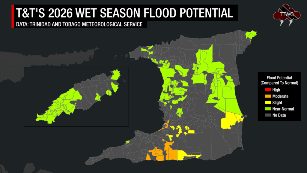
The 2026 Wet Season is forecast to have near-normal to below-normal rainfall overall, but the Trinidad and Tobago Meteorological Service (TTMS) reports that several communities face an elevated risk of flooding, particularly across southern Trinidad.
This is the sixth year the organization has issued flood guidance within its “Flood Potential Outlook” as part of its overall Wet Season climate outlook.
The TTMS is forecasting possible rainfall volumes for the 2026 Wet Season between 672 millimeters and 1848 millimeters across Trinidad, with the maximum occurring in eastern and northeastern Trinidad, in the vicinity of Cumaca, Sangre Grande, Vega De Oropouche, Plum Mitan and environs. In Tobago, rainfall volumes will range between 920 millimeters and 1435 millimeters, with the maximum occurring in areas of Mount St. George, Goodwood and environs.
In their 2026 Wet Season Flood Potential Outlook, the TTMS states, “The flood potential is near normal in central and northern Trinidad, near St Helena, Piarco, Tunapuna, Port of Spain and environs, Diego Martin, Plum Mitan, Arima, La Horquetta and environs, Sangre Grande and parts of Manzanilla, and environs. On the island of Tobago, near-normal potential exists in Scarborough, Crown Point and environs. However, elevated potentials exist in the San Fernando, South Oropouche River Basin, Penal, Debe, Siparia, Moruga and environs.”
This year, there were no high-risk communities, which were only used in 2022, but there was a significant increase in near-normal-risk areas.
Moderate Flood Risk Potential – 17 Communities
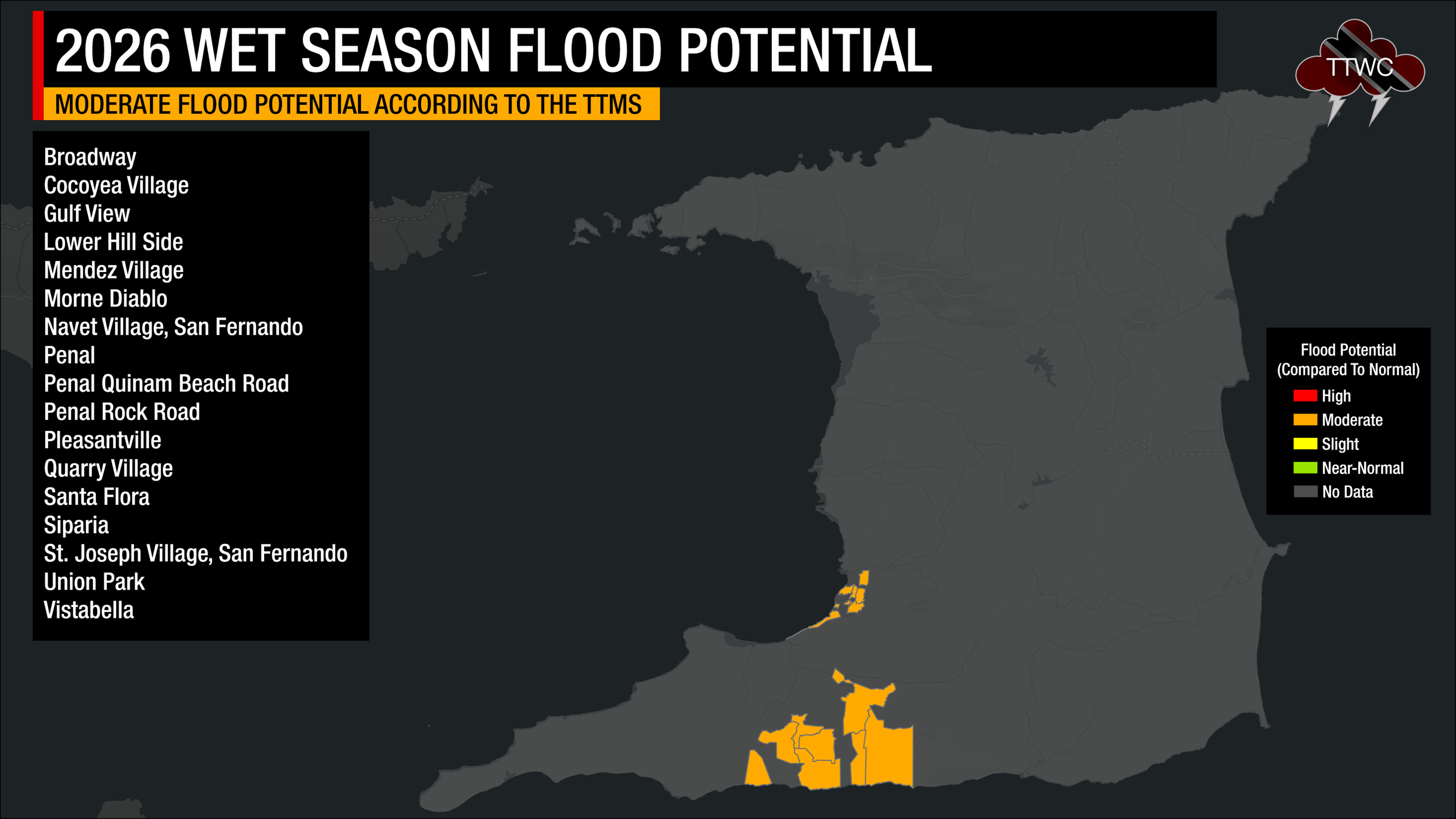
Based on the Met Office’s analysis, 17 communities in Trinidad have a moderately higher-than-normal flood potential.
In Tobago, the TTMS has no communities with a moderately higher-than-normal potential for flooding.
Slight Flood Risk Potential – 16 Communities
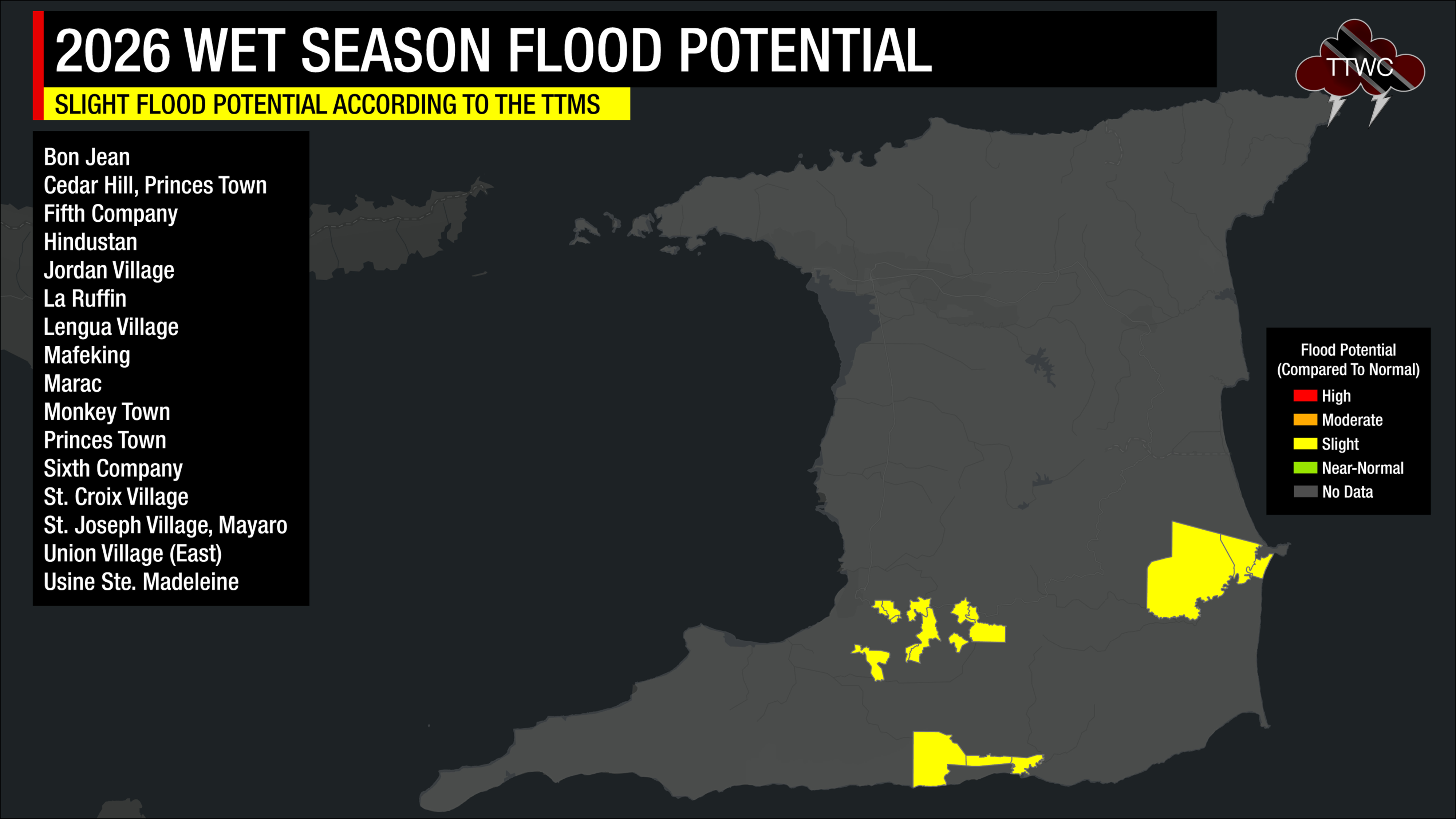
Based on the Met Office’s analysis, the following 16 communities in Trinidad have a slightly higher-than-normal flood risk.
In Tobago, the TTMS highlighted no communities that had a slightly higher-than-normal potential for flooding.
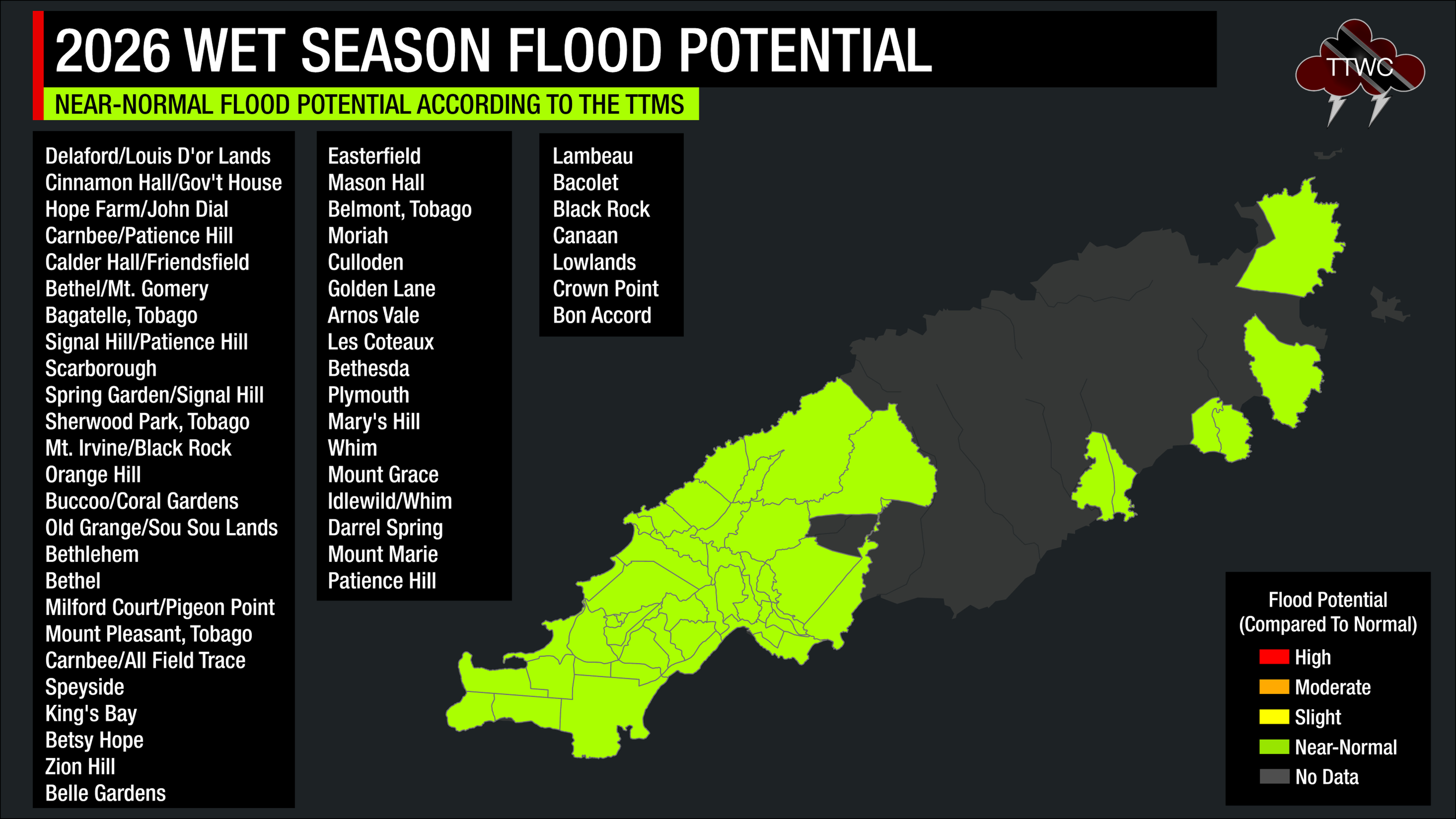
Near-Normal Flood Risk Potential – 159 Communities
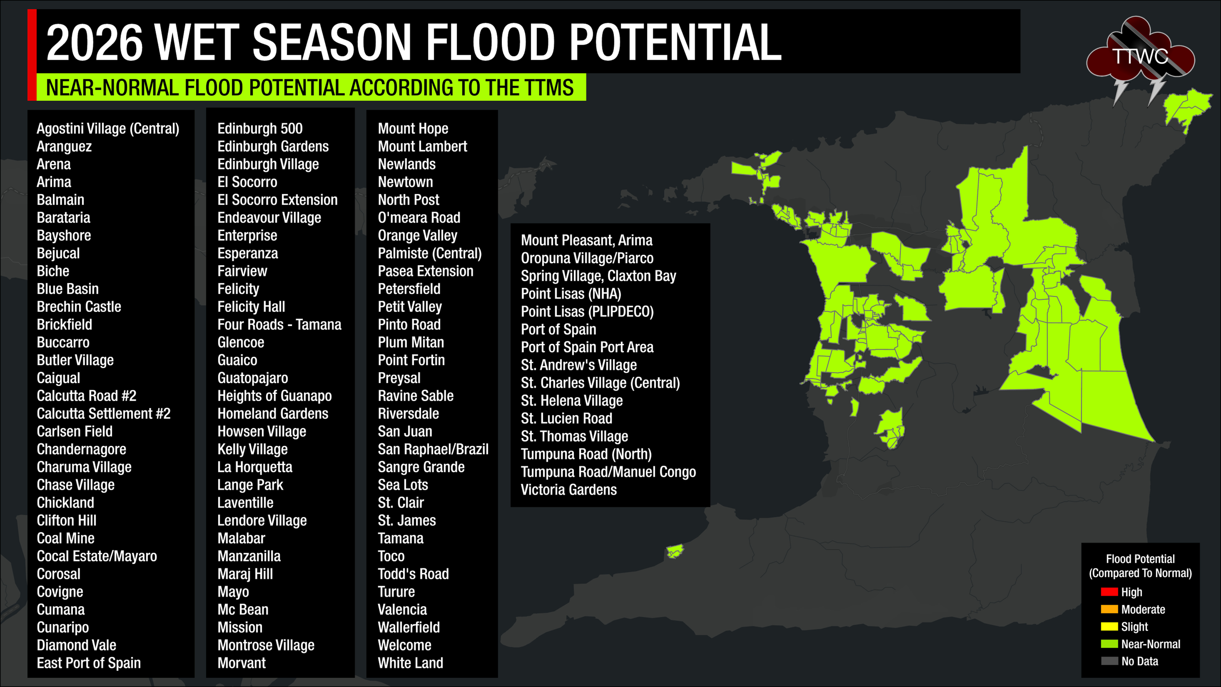
Based on the Met Office’s analysis, 109 communities in Trinidad have near-normal flood potential.
In Tobago, 50 communities have been identified as having a near-normal flood risk.
Comparing This Year’s Flood Potential Outlook
Of the 587 communities across Trinidad and Tobago, 192 carry some flood risk designation in 2026 – the most of any year. However, the severity profile is overwhelmingly mild: 159 of those 192 are Near-Normal, with only 16 Slight and 17 Moderate. Compare that to 2024, where 180 communities were flagged, but 151 of them were Moderate – the highest single-tier count in any elevated category across the entire dataset.
The elevated risk tiers have been falling sharply since 2024. Moderate communities went from 151 (2024) to 29 (2025) to 17 (2026). Slight dropped from 103 (2025) to 16 (2026). The TTMS appears to see 2026 as a structurally lower-risk season than the preceding two years
2022 is the only year the “High” tier has ever been used with 21 communities. That was only the second outlook ever issued, and the TTMS hasn’t returned to that top tier since. However, Near-Normal usage has shifted dramatically. The tier was absent entirely in 2022 and 2024, but used in 2021 (64) and 2023 (47), and then surged to 159 in 2026. This could reflect a methodological shift — the TTMS casting a wider but gentler advisory — or it could genuinely indicate that many historically flood-prone areas are returning to baseline risk after the elevated 2023–2025 period.
When asked how these flood risks are applied to communities at the 2026 National Climate Outlook Forum, the TTMS’s Acting Chief Climatologist, Kidar Kisson, explained, “This is data that we’ve gathered over the years – areas that would normally flood, new areas that are developing. We have our GIS specialist, and we have the risk associated with places that, because of the amount of rainfall expected, would it flood? Places that generally flood will flood. Some areas are newly flooding because it is sometimes man-made, because of infrastructure work or buildings, or planned housing schemes or whatever, where people just narrow up a river.”
2026 has the fewest unflagged communities (395) of any year, meaning the TTMS is flagging more of the country than ever before — but almost entirely in the lowest-risk tier. That’s a very different signal from 2022, when only 81 communities were flagged, of which 21 were High.
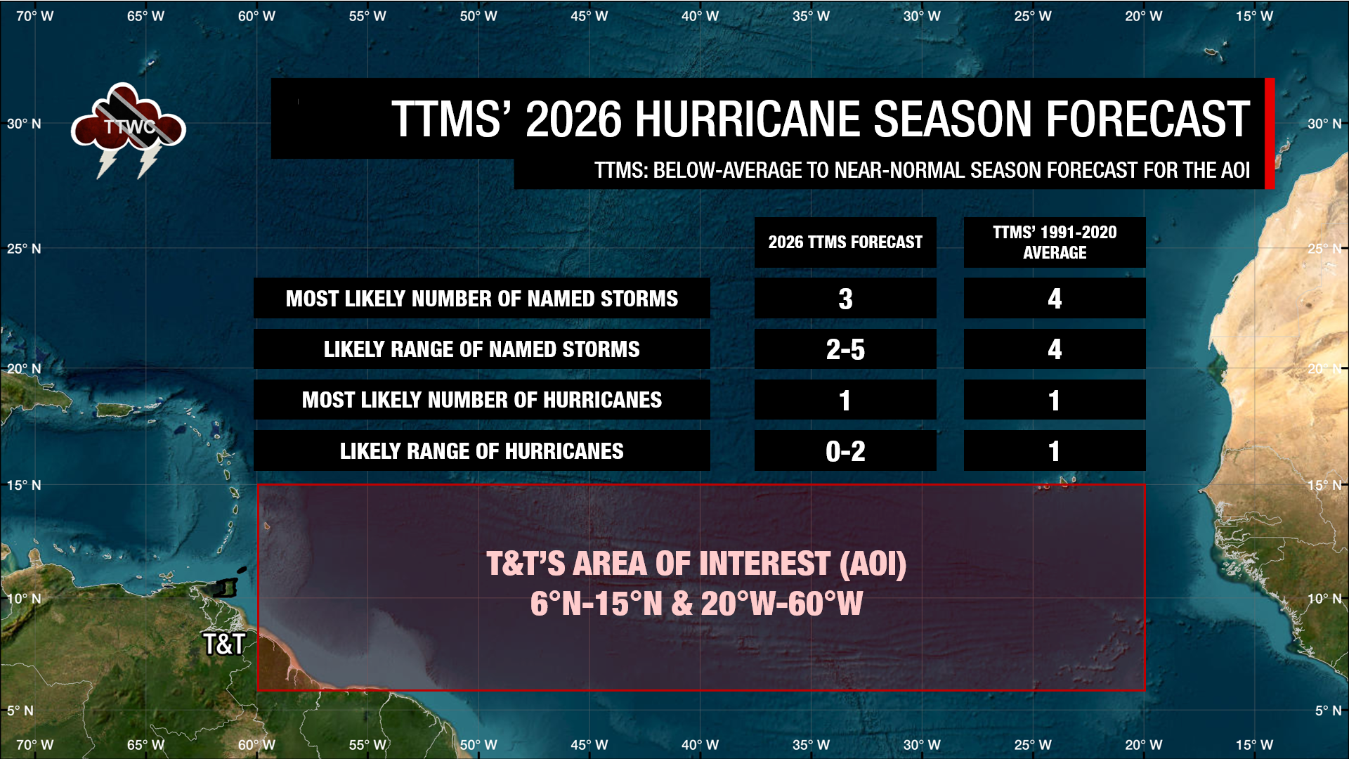
As of mid-May 2026, the equatorial Pacific is rapidly transitioning toward El Niño, with a 98% probability of El Niño during May–July 2026. NOAA predicts a below-normal 2026 Atlantic hurricane season. The last time NOAA forecast a below-average season was in 2015. El Niño increases wind shear across the Atlantic, suppressing tropical development and reducing rainfall enhancement. NOAA says there is a 55% chance the season will be below normal, with only 8–14 named storms forecast.
When can we expect to see most floods?
When the TTMS assesses the flood potential for the country rather than individual communities, it looks at the potential for monthly rainfall exceeding 250 millimeters, 24-hour rainfall exceeding 25 millimeters (a heavy rainfall day), as well as three- and five-day wet spells (days where T&T records consecutive rainfall equal to or more than 10 millimeters).
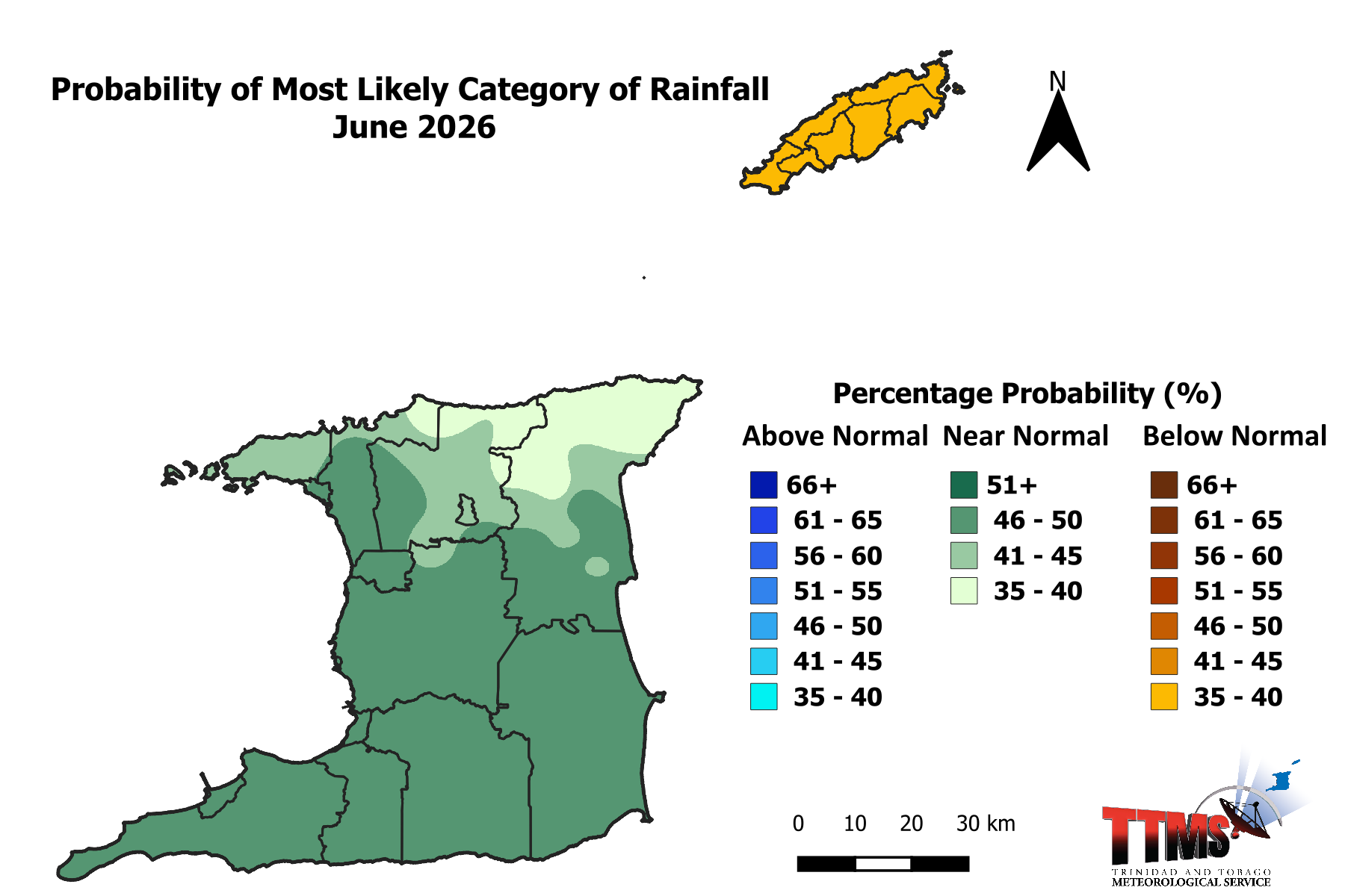
June is forecast to kick off a near-normal Wet Season for Trinidad, with below-normal rainfall expected for Tobago.
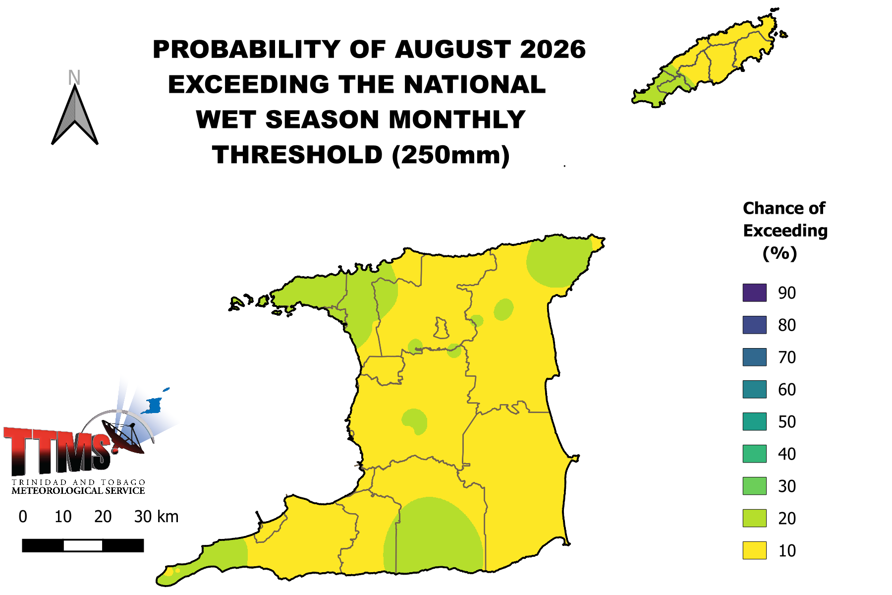
August is Trinidad’s wettest month, climatologically. According to the TTMS, there is a 3% to 16% chance of reaching or exceeding 250 millimeters in Trinidad and an 8% to 15% chance in Tobago.
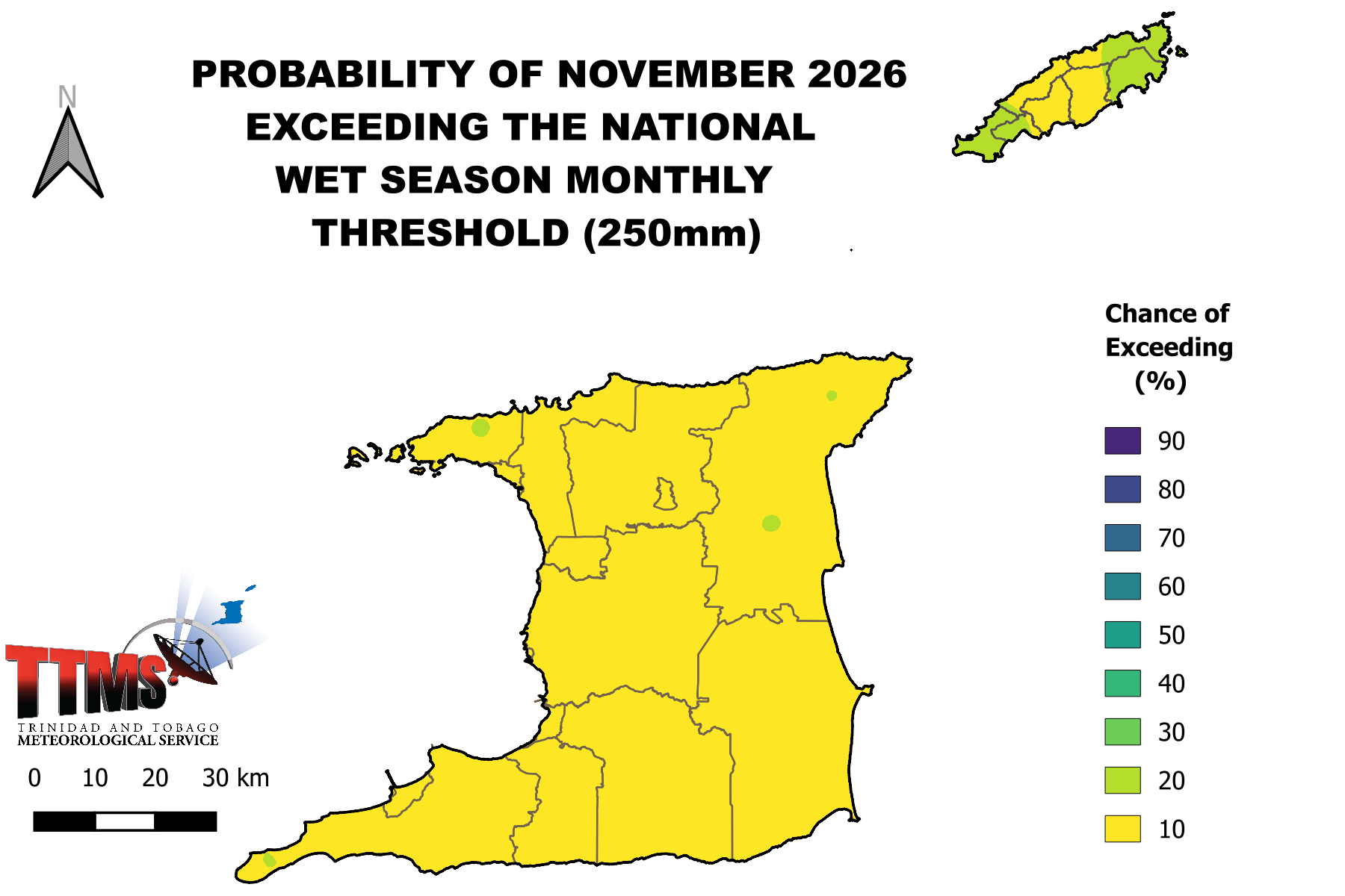
November, the secondary peak of the local Wet Season, has an outlook showing a 2% to 15% chance for November’s rainfall to reach or exceed 250 millimeters, with marginally higher chances across northeastern areas of Trinidad and all of Tobago
Overall, the TTMS indicates a 55% chance of a below-normal number of heavy rainfall days (where T&T receives more than 25 millimeters of rainfall), with the likely range of heavy rainfall days between June and December being 6 to 10. The average (1991-2020) number of heavy rainfall days is 16.
However, when looking at extreme or extremely heavy rainfall days (where T&T receives more than 50 millimeters of rainfall), there is a 60% chance of below-normal heavy rainfall days, with 1 to 3 extremely heavy rainfall days likely, compared to the normal 4 days. According to the TTMS, only one day is likely to have daily rainfall accumulations exceeding 75 millimeters.
Isolated heavy rainfall or extremely heavy rainfall days can be temporarily disruptive, but for longer-lasting riverine flooding to occur, rainfall will need to persist over several days. For 2026, the TTMS forecasts a 46% chance of a below-normal number of three-day wet spells, with four three-day periods likely in which accumulated rainfall reaches or exceeds 10 millimeters, compared to an average of five.
There is also a 52% chance of a below-normal number of five-day wet spells, with the TTMS saying only one five-day period where accumulated rainfall reaches or exceeds 10 millimeters is likely this Wet Season, compared to the 1991-2020 average of two such periods.