As Trinidad and Tobago move through the wet season, the heat will not let up. The Trinidad and Tobago Meteorological Service (TTMS) and the Caribbean Institute for Meteorology and Hydrology (CIMH) both point to a warmer-than-average season ahead, with the Caribbean entering what CIMH describes as another unusually hot Heat Season. Episodes of excessive heat are expected to ramp up, peaking later in the season, and the impact could intensify further if El Niño strengthens.
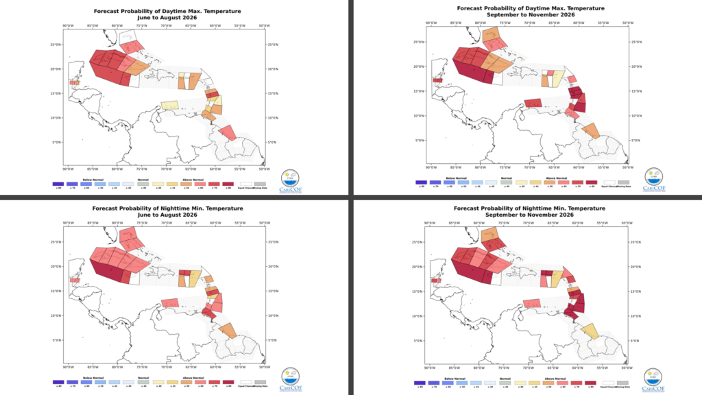
The 2026 wet-season temperature outlook favors warmer-than-average temperatures, particularly across western areas of the country. TTMS gives a moderate (60%) chance of warmer-than-average days in urban and built-up areas of both islands — where the heat tends to concentrate.
The excessive-heat season usually peaks from August to October, and there is a high likelihood during that window that maximum temperatures will reach or exceed 34.0°C, the threshold TTMS uses to define a hot day in Trinidad.
Two peaks, not one
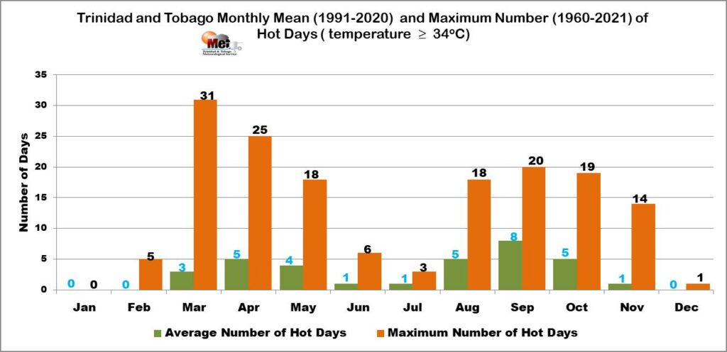
Trinidad and Tobago’s heat season is bimodal. It has an initial peak from March to May and a secondary peak from August to October. That means the early-season warmth many felt in May is, in a sense, the first crest, and a second, often more intense crest is expected to build through the late wet season.
This is reflected in the share of time spent in hot spells across the season:
| Month | Share of time in hot spells |
|---|---|
| May | 20–30% |
| June/July | 0–10% |
| August (Trinidad) | 10–20% |
| August (Tobago) | 0–10% |
| September (Trinidad) | 30–40% |
| September (Tobago) | 20–30% |
| November (Trinidad) | 20–30% |
| November (Tobago) | 10–20% |
The pattern is clear: a quieter stretch in June and July gives way to a steady build from August, with September the most heat-prone month, and Trinidad consistently running hotter than Tobago.
Day and night, both warmer
What sets this season apart is that the heat is expected to be relentless around the clock, and the night-time signal is especially strong:
- June–July–August (JJA): greater than 80% chance of above-normal night-time temperatures, and greater than 50% chance of above-normal daytime temperatures.
- September–October–November (SON): greater than 80% chance of above-normal night-time temperatures, and greater than 60% chance of above-normal daytime temperatures.
Warm nights matter. When temperatures stay elevated after dark, the body gets less chance to recover, compounding heat stress on people, livestock and crops alike. CIMH expects intense night-time and daytime heat especially in August and September.
Hot spells for 2026?
On average (1991–2020), Trinidad and Tobago experiences about 10 to 15 hot-spell days per year, according to CIMH. For 2026, there is a 20–30% chance of at least 30 hot-spell days, a notable step up from the norm, and part of a regional signal of a moderate increase in hot-spell days across Trinidad and Tobago, Barbados, the coastal Guianas, and the Windward Islands.
TTMS adds that there is a moderate chance of elevated 5-day short-duration hot spells and 3-day heat surges (maximum temperatures of 34.0°C or higher) developing during August to October. Cities and urban areas have the highest chance of warmer-than-average temperatures and the most intense heat, with readings most likely to reach or exceed 34.0°C.
What is driving the heat
The dominant driver is the developing El Niño. With a greater-than-80% probability that El Niño will take shape by the end of June, the atmosphere over the Caribbean is set to stabilize, and El Niño conditions tend to bring higher temperatures and more frequent heat waves from summer onward, often persisting into the following year. CIMH explicitly cautions that the level of heat impact will significantly increase if a strong El Niño develops.
Warm sea surface temperatures around the islands reinforce the signal, keeping overnight and coastal temperatures elevated. Cooling demand across the region is expected to rise steeply, peaking in August and September.
What does this mean for you?
Health. This is the season’s primary concern. Excessive heat can amplify and worsen chronic health conditions in vulnerable people, including those with chronic illness, children, pregnant women, and the elderly. Expect a greater frequency of heat symptoms and a heightened risk of heat illness, fainting, and hospitalizations during the August–September peak. There is also a likely increase in biological risk, including mosquito-borne and gastrointestinal disease. Stay hydrated, limit strenuous activity during peak afternoon hours, and check on those most at risk. The health sector is advised to revisit contingency plans for spikes in excessive-heat ailments.
Energy. The need to run air-conditioning and other cooling machines during hot spells will push up household electricity bills, and demand for cooling will climb steeply in homes, hotels, and restaurants. Power generation itself becomes less efficient in extreme heat, raising the risk of interruptions as cooling demand spikes strain the grid.
Water. Warmer-than-usual temperatures mean warmer water and greater evaporation, slowing the recharge of reservoirs already running below normal this wet season and raising the potential for algal blooms. Warmer water temperatures are particularly significant for aquaponic systems and fish health.
Agriculture and food security. Hot days and hot spells cause heat stress in livestock and wilting in newly transplanted and younger crops, with reduced productivity in the field between roughly 10 AM and 3 PM. Livestock will need additional cooling and ventilation; broiler growth, egg production, and dairy production can suffer. Warmer waters can also affect fisheries.
Tourism and the workplace. Hotels face significantly higher cooling and refrigeration costs, while outdoor and warehouse workers face increased exhaustion and reduced productivity if unprotected. Schedule demanding work for the cooler parts of the day where possible.
Disaster management and education. Intense heat in the immediate aftermath of any tropical system raises mortality risk and cooling needs, and dry fuel stock heightens wildfire potential. For students, prolonged heat can reduce learning ability and productivity at the start of the new school year.
The bottom line
Expect a warmer-than-average season, especially in western and urban areas, with above-normal day and night temperatures and a strong night-time heat signal. After a quieter June and July, heat ramps up through August and peaks in September, with elevated chances of 34.0 °C-plus readings and short-duration hot spells from August into October. With a developing El Niño in the background, the risk of a hotter, more impactful heat season is real — making hydration, cooling planning and care for vulnerable people the priorities for the months ahead.
Sources: Trinidad and Tobago Meteorological Service’s Rainfall and Temperature Outlook for the Wet Season 2026; Caribbean Institute for Meteorology and Hydrology/Caribbean Climate Outlook Forum’s Heat Outlook for June to November 2026, and supplementary CIMH heat-season guidance.
Compilation: Trinidad and Tobago Weather Center.