


Showers and thunderstorms are in Trinidad and Tobago’s forecast into next week as deep-layered moisture moves in and across the region. By late Sunday, Saharan Dust is forecast to return, potentially reducing rainfall across the area.
What you need to know
— Saharan Dust: A surge of Saharan Dust is set to move across the islands from late Sunday. The presence of the Intertropical Convergence Zone may shield T&T from the highest dust concentrations.
— Rainfall: Isolated to scattered showers and thunderstorms are forecast well into next week. Over the next five days, overall rainfall totals between 50 and 150 millimeters are forecast across most of the country. However, isolated totals of up to 200 millimeters of rain are possible across localized areas of Trinidad.
— Hazards: The main hazards are street/flash flooding over the next five days. Gusty winds up to and over 45 KM/H are likely to accompany heavier showers and thunderstorms. The chances for riverine flooding remain low at this time. Lightning will accompany thunderstorms. Landslides are possible, particularly by Sunday, as soils become increasingly saturated.
— Alerts/Watches/Warnings: There are no alerts, watches, or warnings in effect for Trinidad and Tobago from the Trinidad and Tobago Meteorological Service at this time. There are no tropical storm or hurricane watches or warnings in effect for T&T at this time.
The Forecast
Friday Evening
Friday EveningSaturday
SaturdaySunday
SundayMonday
MondayTuesday
TuesdayWednesday
WednesdayMarine: Through Wednesday, seas are forecast to be slight, with waves in open waters generally below 1.25 meters. In sheltered areas, waves are forecast to be near calm but occasionally choppy in the vicinity of heavy showers/thunderstorms.
Temperatures
Through the forecast period, the minimum low in Trinidad and Tobago is forecast to be between 24.0°C and 26.0°C.
Over the next five days, maximum highs across the country are forecast to be up to 32.0°C in Trinidad and Tobago, though cooler maximum highs are possible across both islands due to increased cloud cover. In urbanized areas like Port of Spain, Scarborough, San Fernando, and Chaguanas, the maximum high temperatures will trend warmer.
Forecast Impacts
Flooding
FloodingThere is a high chance of street and flash flooding, particularly across western coastal, central, and eastern Trinidad. Chances for riverine flooding remain low at this time.
Forecast Rainfall Totals
- Friday: Between 5 and 15 millimeters across both islands, with higher rainfall totals up to 25 millimeters favoring eastern, southern, and western coastal areas of Trinidad. Locally higher amounts exceeding 75 millimeters are possible across eastern Trinidad and Tobago.
- Saturday: Across Tobago, less than 15 millimeters of rainfall is forecast. Across Trinidad, between 10 and 25 millimeters of rainfall is forecast, trending higher across western coastal and central Trinidad. In areas of intense showers or thunderstorms, particularly across Trinidad, isolated 24-hour rainfall accumulations could exceed 25 millimeters.
- Sunday: Between 10 and 25 millimeters of rainfall across both islands, trending higher towards 50 millimeters across Trinidad. In areas of intense showers or thunderstorms, particularly across Trinidad, isolated 24-hour rainfall accumulations could exceed 50 millimeters.
- Monday: Across Tobago, less than 15 millimeters of rainfall is forecast. Across Trinidad, between 10 and 25 millimeters of rainfall is forecast, trending higher across southern, eastern, and western coastal Trinidad.
- Tuesday: Across both islands, between 10 and 25 millimeters of rainfall is forecast, trending higher across the eastern and southern halves of Trinidad.
- Wednesday: Across both islands, between 5 and 15 millimeters of rainfall is forecast, trending higher across Tobago, southern, and western coastal areas of Trinidad.
Putting the rainfall forecast into context, rainfall rates in excess of 50 millimeters per hour or areas that receive in excess of 25 millimeters within an hour tend to trigger street flooding across the country or flash flooding in northern Trinidad. For riverine flooding to occur, a large area of the country (not just in highly localized areas of western coastal Trinidad) would have to record upwards of 75 millimeters within 24 hours, and rainfall would have to fall across major rivers’ catchment areas.
Strong Thunderstorms
Strong ThunderstormsThe chances of strong thunderstorms are medium as a low shear, high moisture, moderate to high instability, and light wind environment is in place through the forecast period, while peak favorable conditions are forecast on Sunday.
Funnel cloud development is possible through Tuesday due to near calm to light and variable winds. The highest chances for funnel cloud/waterspout development exist along western coastal areas of both Trinidad and Tobago, as well as along southern and eastern coastal areas of Trinidad. If a funnel cloud touches down on a body of water, it becomes a waterspout; if it touches down on land, it becomes a tornado.
Abundant frequent cloud-to-ground lightning is possible, accompanying thunderstorms.
Gusty Winds
Gusty WindsWith wind gusts up to and in excess of 55 KM/H, whole trees are expected to be in motion, and there may be some inconvenience when walking against the wind gusts. Light outdoor objects may topple or become airborne such as garbage cans, potted plants, loose galvanize or construction material, and other outdoor furniture. Tents may jump. Older/weaker trees may fall, bringing down utility poles and lines.
Other Hazards
Saharan Dust is forecast to increase across the region by late Sunday into Monday, reducing visibility and air quality.
Why I May Not/Will Not See Rainfall?
A frequent complaint is the forecast is wrong because I didn’t experience any rainfall. Scattered showers mean that you, individually, may experience some showers intermittently throughout the day, and there is a higher chance for this activity than isolated activity. Widespread showers mean that nearly all persons and areas may experience rainfall.
Isolated to scattered showers and thunderstorms are forecast from Friday through next Tuesday across both islands.

Forecast Discussion
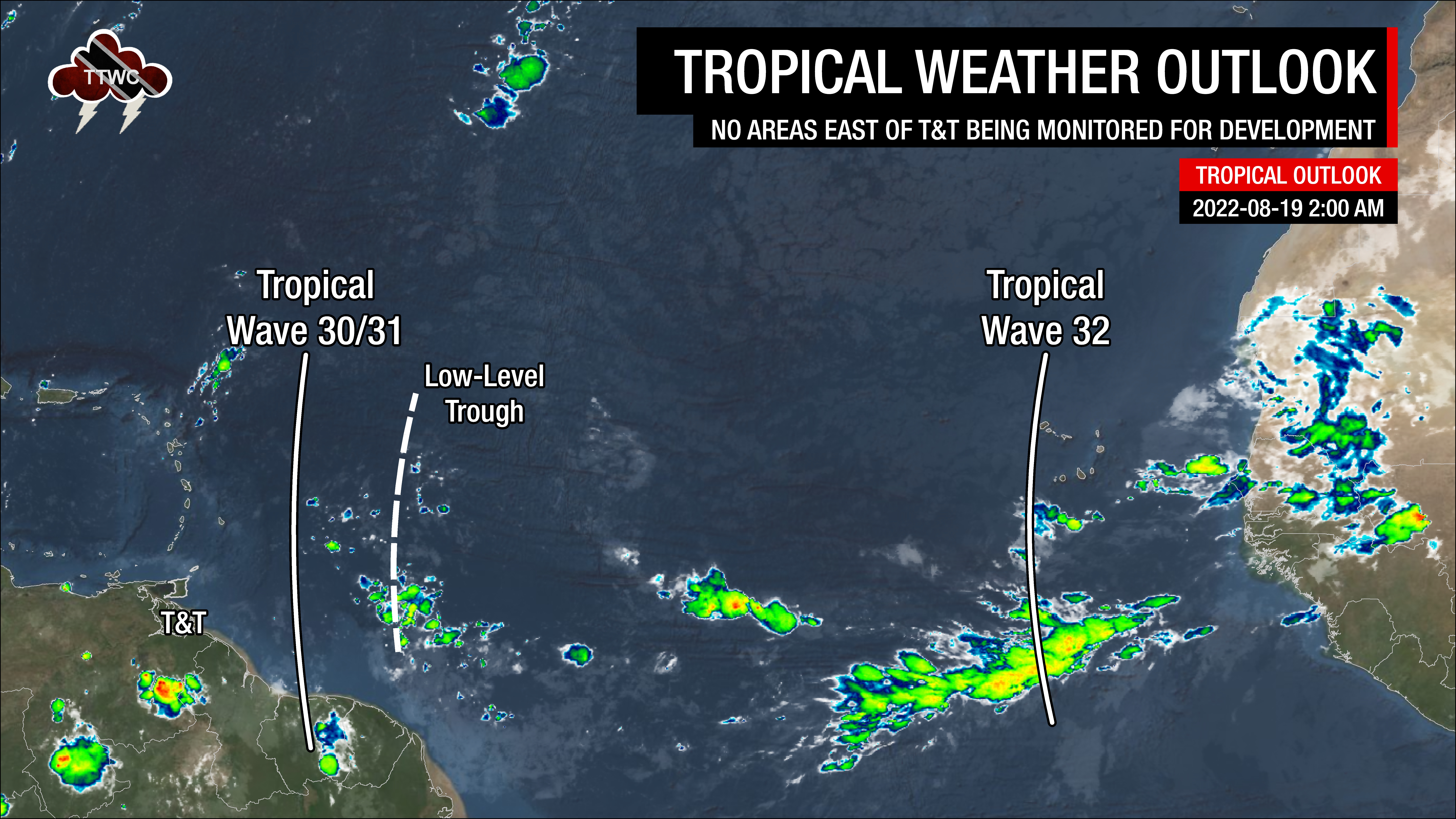
Tropical Waves (and other features) near and east of T&T: Based on the Tropical Analysis and Forecast Branch’s 00Z surface analysis on August 19th, 2022, as well as the latest satellite and model guidance:
- The 30th/31st tropical wave for 2022 (TW30/31) is along 56°W, south of 20°N, moving west at 15 to 20 knots (28-37 KM/H). Isolated showers are ongoing following the wave axis, where a surface to low-level trough exists, interacting with the Intertropical Convergence Zone. This wave is forecast to move across T&T and the Lesser Antilles by late Friday into Saturday, with the trough moving across the area by Saturday night.
- The 32nd tropical wave for 2022 (TW32) is along 25°W, south of 20°N, moving west at 5-10 knots (9-18 KM/H). Isolated to scattered moderate convection is noted from 6°N-14°N between 18°W and 27°W. This wave is forecast to move across the Lesser Antilles by next Saturday.
Following this week’s mostly sunny, hazy and relatively hot weather, a welcome change is on the horizon for those longing for marginally cooler temperatures and wetter weather.
Instability and increased atmospheric moisture are forecast to begin affecting Trinidad, Tobago, and the Windwards from this (Friday) morning, fuelling isolated to scattered showers and variably cloudy skies. Wind shear is set to remain light to moderate, while atmospheric moisture at mid to upper levels of the atmosphere remains fairly limited.
By this (Friday) evening, TW30/31 is forecast to move westward into the Caribbean Sea. Deep-layered moisture trailing the wave, as well as the Intertropical Convergence Zone (ITCZ), is forecast to remain across Trinidad and Tobago into the weekend. A surface to low-level trough trailing the tropical wave is also forecast to interact with the ITCZ, aiding in shower and thunderstorm development.
By Saturday into Sunday, increased mid to upper-level instability is forecast to maintain unsettled conditions across Trinidad and Tobago, which is set to continue into next week.
A tempering hand, though not well captured on the latest numerical weather prediction models, will be Saharan Dust by late Sunday into next week. Though the ITCZ is forecast to remain across T&T, potentially shielding the country from higher dust concentrations, a marginally drier low to mid-level atmosphere may decrease rainfall potential. Low-level conditions become less favorable late Sunday into Monday, though mid to upper-level moisture remains abundant.
Localized climatic effects are also forecast to play a role over the next several days. Across areas that experience sunshine during the mid to late morning, this heating of the low levels of the atmosphere will add additional instability into the mix – what we usually call daytime heating – and trigger showers and thunderstorms.
With light winds, at times coming from the south, both sea breeze convergence and orographic effects (particularly across Trinidad’s Southern, Central, and Northern Ranges, as well as Tobago’s Main Ridge) are forecast to enhance the development of showers or thunderstorms. This will increase the flood potential across Trinidad.
Into next week, atmospheric conditions appear to remain relatively unchanged with light winds, high moisture, and the ITCZ still present, leading to additional rainfall for both islands.


