With Tropical Storm Bret passing safely north of Barbados and St. Vincent and the Grenadines, Trinidad, and Tobago will be spared from the tropical storm’s winds and heaviest rainfall. However, there is the possibility of feeder bands extending southward from Bret’s center and affecting parts of T&T, particularly from Wednesday night through Friday night. From Friday night into the weekend, mostly settled, sunny, and hazy weather returns.
What you need to know
— Rainfall: Forecast models indicate over the next five days, between 15 and 40 millimeters of rainfall are possible across both islands. However, feeder band activity between Wednesday and Friday could lead to isolated rainfall accumulation exceeding 50 millimeters in localized areas. As of Wednesday morning, models keep the highest rainfall accumulations offshore T&T. Over the weekend, no significant rainfall is forecast.
— Saharan Dust: A surge of Saharan Dust is forecast to return to the area from Friday evening, with another surge arriving by Monday.
— Hazards: Through Friday, street/flash flooding and gusty winds are forecast to be the main hazards in heavy showers and thunderstorms, particularly associated with feeder band activity associated with Tropical Storm Bret. In and ahead of heavy showers or thunderstorms, sustained winds can reach 35 KM/H, with wind gusts expected to exceed 45 KM/H, particularly overnight Thursday into Friday, with higher gusts possible. There is the potential for landslides in elevated areas, particularly in areas that receive persisting rainfall, with areas across Tobago most at risk. From Friday night, the main hazard shifts to an increase in Saharan Dust, decreasing air quality.
— Marine: On Wednesday, seas in open waters are forecast to remain slight to moderate, with waves between one and two meters and in sheltered areas smooth, with spring tides subsiding. By Thursday, with variable winds and agitated seas from the northeast, seas can become moderate to locally rough.
Latest Alerts
Hazardous Seas Alert Discontinued For T&T
Trinidad and Tobago is NOT under any tropical storm or hurricane threat, watch, or warning at this time.
The Forecast
Wednesday
WednesdayThursday
ThursdayFriday
FridaySaturday
SaturdaySunday
SundayMarine Forecast
Seas Forecast: Moderate Seas, Reduced Visibility
Temperatures
Although increased cloud cover is forecast from Wednesday through Friday, light to near calm winds, then a sunny weekend with high humidity will lead to warmer than average nighttime lows and daytime highs. On Thursday, hot temperatures are forecast between 32°C and 35°C, trending higher across urbanized areas.
Wednesday through Sunday
Low: 24-27°C
High: 30-34°C
Maximum high temperatures are forecast to range between 30°C to 34°C, with higher temperatures across urbanized areas of Trinidad, where in built-up areas, maximum high temperatures could exceed 33°C. Overall hotter days are forecast from Friday. Minimum lows are forecast to remain mild, ranging between 24°C and 27°C in Trinidad and Tobago, trending cooler in interior areas. The heat index will generally be near or above 34°C.
Forecast Impacts
Flooding
FloodingForecast Rainfall Totals
- Wednesday: Between 5 and 10 millimeters of rain across both islands, with isolated totals of up to 15 millimeters favoring Tobago, eastern and western coastal areas. Locally higher totals are possible in feeder band activity associated with Tropical Storm Bret.
- Thursday: Between 5 and 10 millimeters of rainfall across both islands, with totals nearing 25 millimeters across Tobago, northern and eastern halves of Trinidad, as well as localized areas along western coastal Trinidad. Locally higher totals are possible in feeder band activity associated with Tropical Storm Bret.
- Friday: Between 5 and 10 millimeters of rainfall across both islands, with isolated totals up to 25 millimeters where feeder-band activity develops. Models indicate this may happen along eastern Trinidad and within the Gulf of Paria. Locally higher totals are possible in feeder band activity associated with Tropical Storm Bret.
- Saturday: Between 0 and 5 millimeters across both islands, with higher accumulations favoring the southern and eastern coastal areas of Trinidad, where totals can be near 15 millimeters.
- Sunday: Little to no rainfall across both islands, with isolated totals in brief passing showers accumulating up to 5 millimeters, favoring southern and eastern areas of both islands.
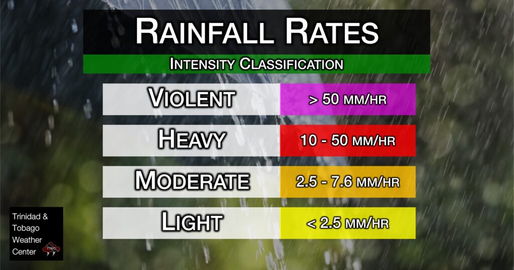
Putting the rainfall forecast into context, rainfall rates in excess of 50 millimeters per hour or areas that receive in excess of 25 millimeters within an hour tend to trigger street flooding across the country or flash flooding in northern Trinidad. For riverine flooding to occur, a large area of the country (not just in highly localized areas of western coastal Trinidad) would have to record upwards of 75 millimeters within 24 hours, and rainfall would have to fall across major rivers’ catchment areas.
Understanding Rainfall Rates

Strong Thunderstorms
Strong ThunderstormsWhat is a strong or severe thunderstorm?
Given how rare these types of thunderstorms are in our region – we classify a severe or strong thunderstorm as one that produces any of the following:
- Damaging wind gusts exceeding 55 KM/H;
- Frequent lightning (more than 30 cloud-to-ground strikes within a 10-minute period);
- Hail (of any size);
- Rainfall of more than 50 millimeters or more within an hour or exceeding 75 millimeters or more within three hours;
- The sighting of a funnel cloud or touchdown of a waterspout/tornado associated with the thunderstorm.
Gusty Winds
Gusty WindsPossible impacts include localized wind damage to trees, power lines, and small structures. Small potted plants may blow over with light outdoor objects becoming airborne in stronger gusts. Tents may jump. Localized power outages are possible.
Other Hazards
Saharan Dust Forecast
Major Saharan Dust Surge Now Moving Across T&T
Why I May Not/Will Not See Rainfall?
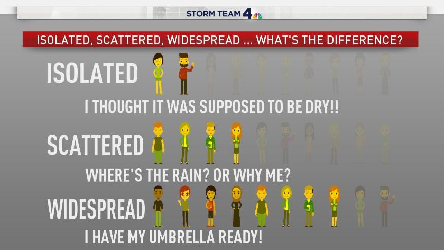
A frequent complaint is the forecast is wrong because I didn’t experience any rainfall. Scattered showers mean that you, individually, may experience some showers intermittently throughout the day, and there is a higher chance for this activity than isolated activity. Widespread showers mean that nearly all persons and areas may experience rainfall.
On Wednesday through Friday, isolated to scattered showers and thunderstorms are forecast, with highly isolated rains over the weekend.

Forecast Discussion
On Wednesday, Tropical Wave 14 is forecast to move west across Trinidad and Tobago. This tropical wave is well-defined and has already brought showers and thunderstorms to the island chain north of T&T, with locally heavy rainfall across eastern areas of Trinidad and across Tobago.
While convergence trailing this wave, accompanying a marginal surge in easterly winds, is forecast to support some showers, cloudiness, and isolated thunderstorm activity, the main influencer on T&T’s weather through Friday night will be Tropical Storm Bret.
Tropical Storm Bret’s core is forecast to remain north of Barbados and St. Vincent, with the latest forecast track from the National Hurricane Center on Wednesday morning showing the center tracking near St. Lucia. Most of Bret’s tropical-storm-force winds and heaviest rains remain near and north of the center of circulation, sparing T&T.
However, as Bret nears the region from Wednesday night, winds across T&T are forecast to become northeasterly to northerly, meaning showers and thunderstorms will be moving in from the northeast/north, with the Main Ridge and Northern Range providing enhancement for heavier rainfall/thunderstorms into Thursday.
On Thursday, as Bret begins to move north of T&T, a deep-layered trough extending southwestward from the center of circulation is forecast to move across T&T in tandem with Bret. The result is light to near-calm winds and warm temperatures, but localized climatic effects take over in triggering shower and thunderstorm activity. Sea breeze convergence and daytime heating will initiate showers and isolated thunderstorms along the southern, western, and eastern coastlines of Trinidad and slowly move northward. Then, as convection encounters mountainous terrain, orographic enhancement may produce heavier rainfall and stronger convection, particularly across central and northern Trinidad.
By Thursday night into the wee hours of Friday, as Bret pulls into the Caribbean Sea, increased southwesterly winds (up to 25 knots or 46 KM/H) will support fast-moving showers and thunderstorms moving from the southeast to northwest, with the Northern Range and Main Ridge providing some enhancement.
From late Wednesday through late Friday, the wild card will be where feeder band activity sets up. Feeder bands, in tropical meteorology, are lines or bands of convection (showers and/or thunderstorms) that spiral into and around the center of a tropical system. Feeder bands can set up what is known as training – where rainfall falls over the same region over a short period of time – resulting in localized areas of very high rainfall accumulations. While forecasting the exact location of feeder bands is notoriously hard to forecast, current weather prediction models show most staying offshore in the Gulf of Paria and east of Trinidad and Tobago. However, if these bands affect land areas, flooding is expected due to potential violent rainfall rates.
By Saturday, a weak high-pressure ridge returns, with Saharan Dust levels increasing, leading to a mostly settled and breezy end to what may be an active weather week.


