Although the first tropical wave for 2026 has yet to be analyzed in the Atlantic, historically, but not always, the Wet Season is declared in May. Trinidad and Tobago’s transition into the 2026 Wet Season is forecast to bring divergent rainfall outcomes across the two islands, with near-normal totals expected over Trinidad and below-normal totals favored over Tobago, according to the Trinidad and Tobago Meteorological Service (TTMS).
Rainfall Outlook For May-July 2026
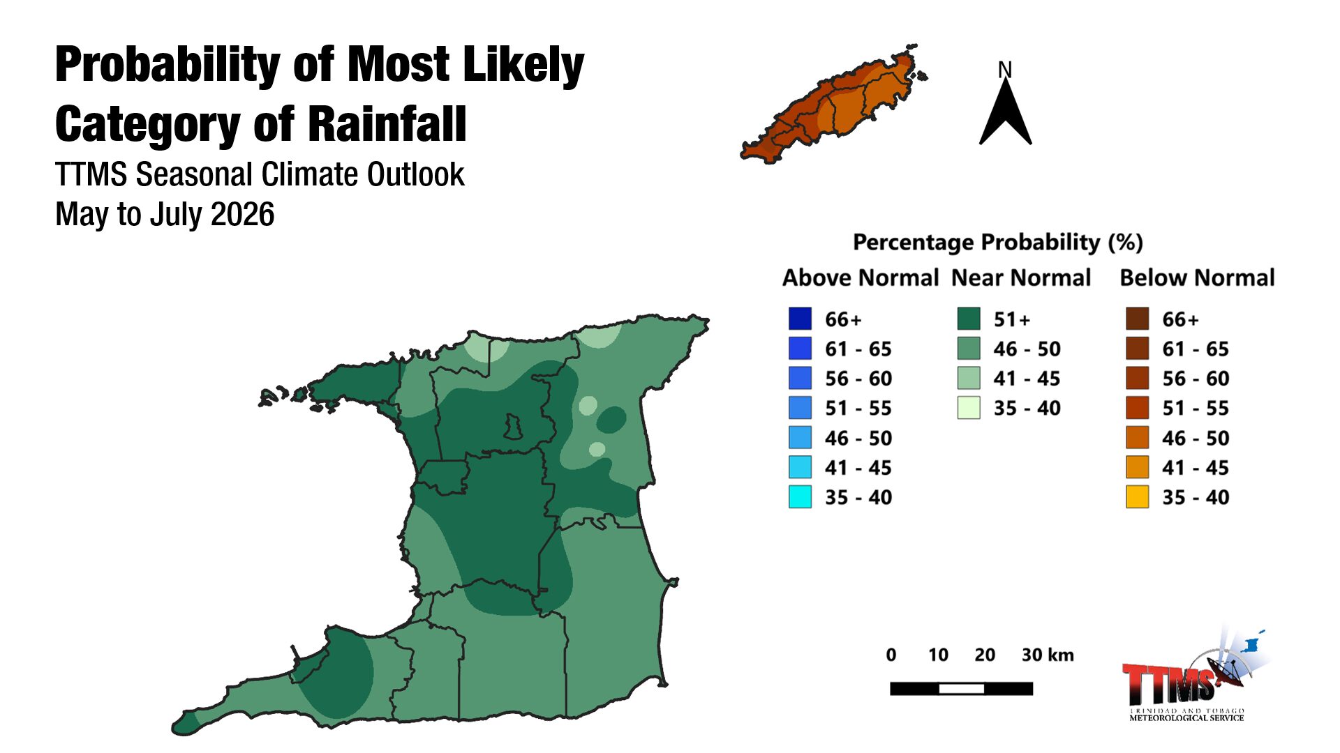
According to the TTMS, the May–July (MJJ) 2026 period is most likely to deliver near-normal rainfall across Trinidad, while Tobago is favored to receive below-normal rainfall amounts.
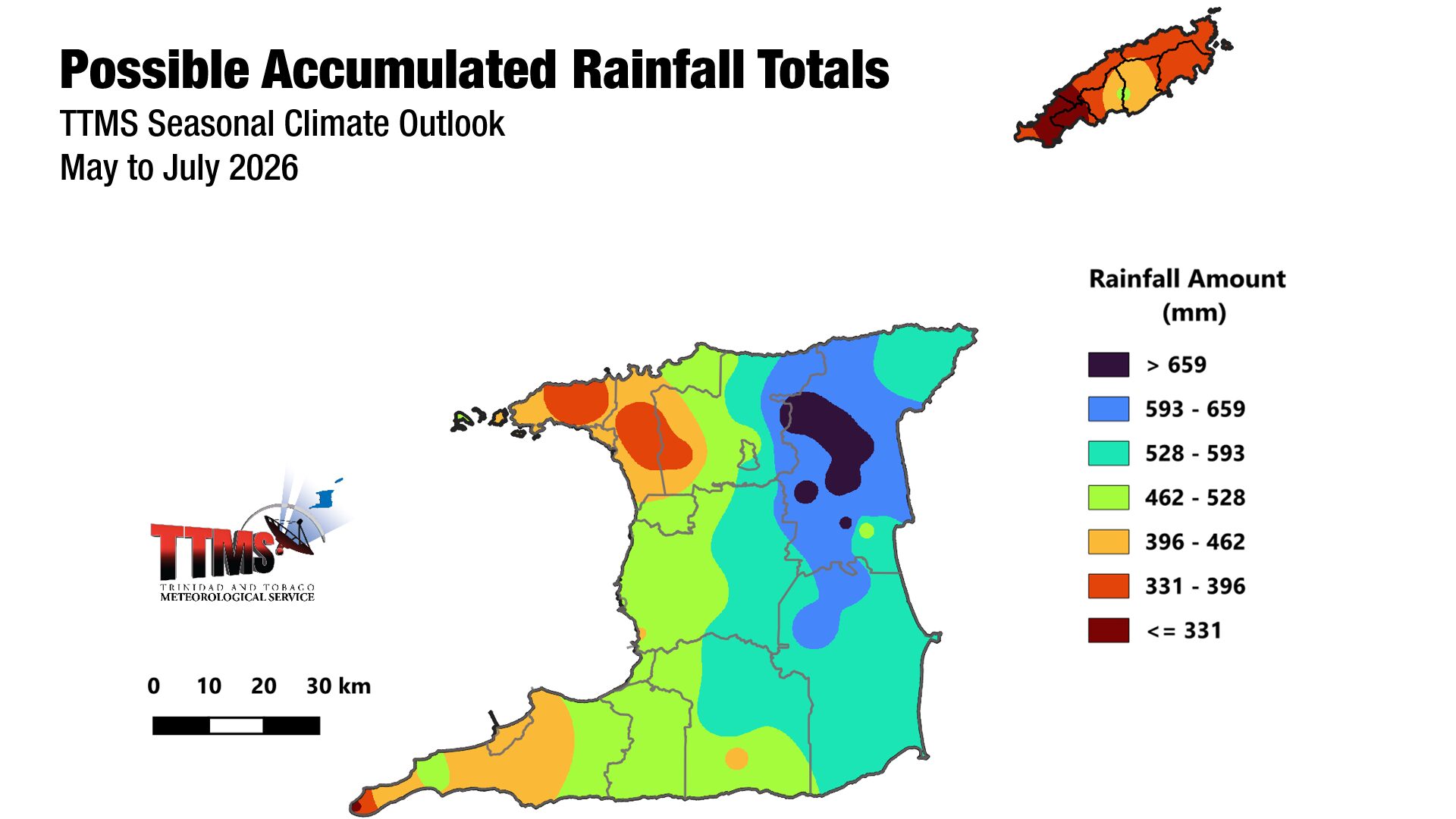
Northern and eastern Trinidad, including areas such as North Oropouche, Valencia, and Sangre Grande, are favored to receive the highest accumulated totals, which could reach up to 756 mm over the three-month period. In central Tobago, areas such as Goodwood and Fort Granby are forecast to record around 469 mm.
Near-normal rainfall is defined as rainfall totals within the middle one-third of the historical record for the same period, per TTMS’ methodology.
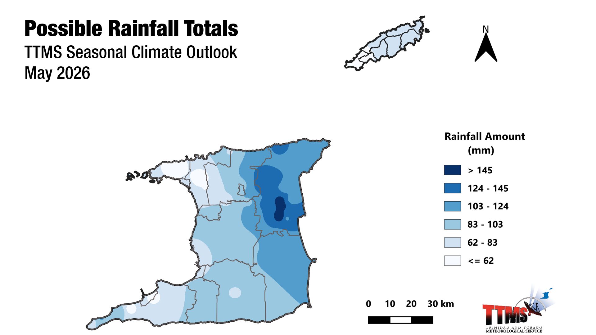
For May 2026 specifically, rainfall totals with the highest chance of occurrence range from 40 to 169 mm across Trinidad and from 50 to 81 mm across Tobago.
Risk of Extreme Low Rainfall
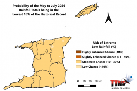
The TTMS’ outlook gives a low to moderate (6–25%) chance of extremely drier-than-normal conditions over Trinidad for May to July, while the risk over Tobago is moderate (11–19%).
Although the overall risk remains manageable, the elevated chance over Tobago aligns with the TTMS’s broader dryness outlook, which flagged borderline-to-slight dry conditions developing across Tobago and central Trinidad heading into July and August 2026.
August-October 2026 Outlook
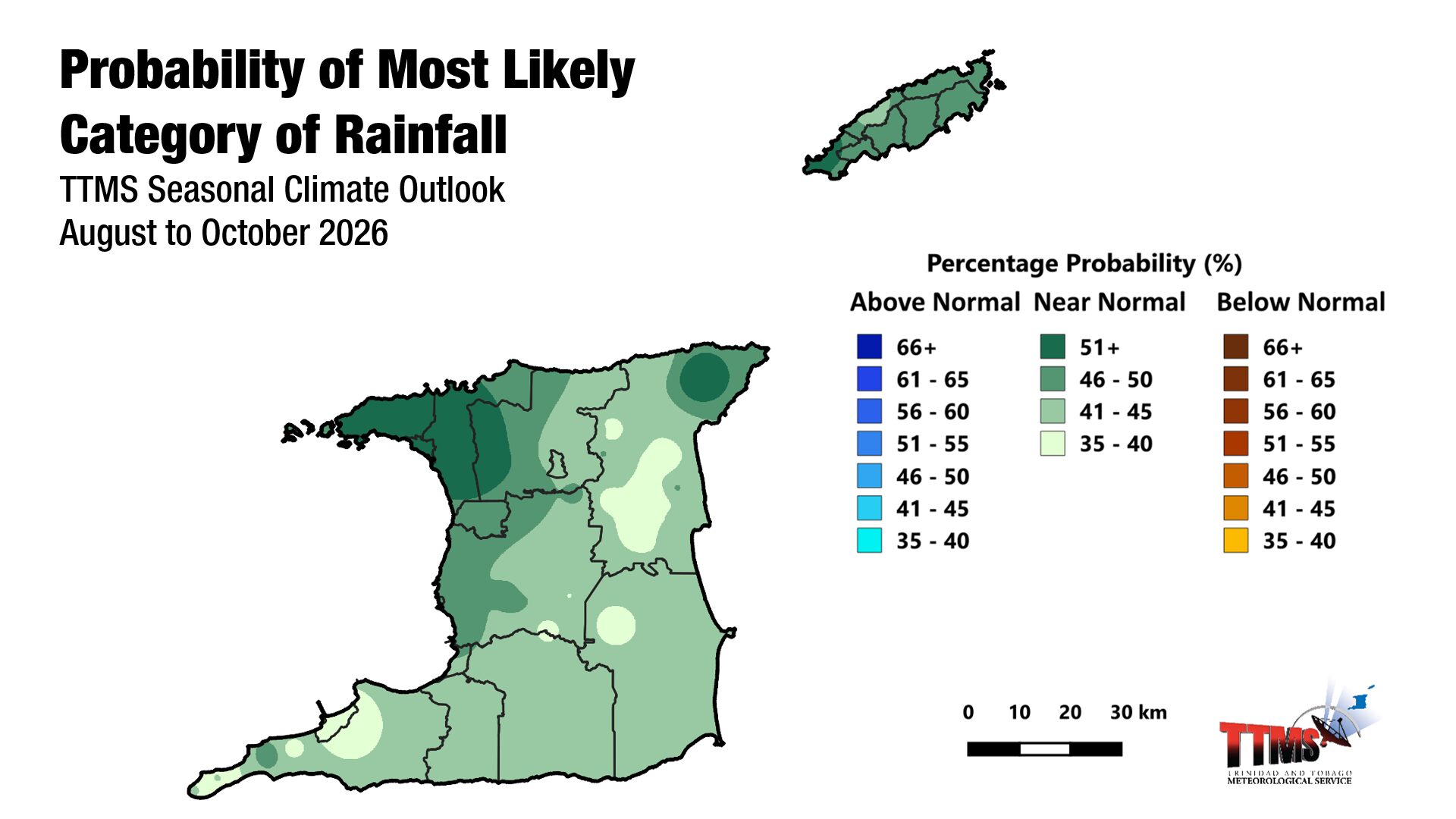
Looking further ahead into the heart of the Wet Season, the TTMS gives a moderate probability (30–63%) of near-normal rainfall totals across both Trinidad and Tobago during the August to October (ASO) 2026 period.
This signals a likely return to more typical Wet Season behavior after the drier transition expected for Tobago between May and July.
Recent Dryness Observations
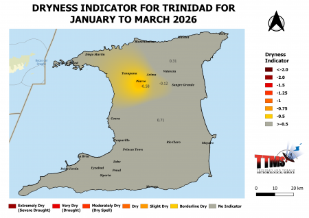
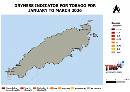
Heading into May, conditions across Trinidad and Tobago have already trended drier than usual in several areas. By the end of March 2026, the TTMS observed below-normal rainfall at Piarco in north-central Trinidad and Crown Point in southwest Tobago, with March totals of 23.8 mm and 27.9 mm, respectively, roughly 65% and 59% of the long-term average.
Vegetation browsing was noticeable across north-central and western Trinidad by the end of March, and borderline dry conditions had developed around Piarco and in north-central Trinidad during January–March 2026.
What’s Influencing T&T’s transition into the 2026 Wet Season?
The weak La Niña that influenced the early Dry Season has since ended, with climate models giving a moderate probability (61%) that El Niño conditions will develop between May and July and continue through the end of 2026. El Niño typically suppresses rainfall across the southern Caribbean during the Wet Season.
Sea surface temperatures in waters surrounding Trinidad and Tobago and farther east of the islands are currently average to slightly above average, and most surveyed climate models indicate these conditions will persist through July 2026.
The North Atlantic Oscillation was in a strong positive phase throughout April but is forecast to shift to a weak negative phase in May, contributing a small positive influence on local rainfall. Surface wind speeds are expected to be normal to above-normal during the May–July period.
The Madden-Julian Oscillation (MJO) has stalled in the Indian Ocean and is not expected to enhance rainfall over Trinidad and Tobago during May 2026. Similarly, equatorial Rossby and Kelvin waves are not anticipated to drive rainfall in May.
What does this mean for you?
With Tobago favored to receive below-normal rainfall and central Trinidad showing signs of borderline dryness, water conservation, storage, and management remain priorities for households, particularly in southwestern Tobago and central areas of Trinidad.
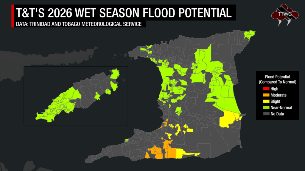
Despite the overall outlook, short-duration heavy showers can still trigger flash flooding, waterlogged soils, and ponding in flood-prone and low-lying areas. The TTMS notes that the potential for flooding from May to July is moderate.
Farmers may need to implement soil moisture conservation practices such as mulching and trenching, clear vegetation from crop beds and drains to ease waterlogging, and put disease-control measures in place.
For the water, drainage, and energy sector, the TTMS recommends water harvesting and storage, routine de-silting of channels, canals, and reservoirs, and the removal of dry branches and overhanging trees near electrical wires and houses.
The risk of bush, forest, and landfill fires also warrants vigilance, especially in areas where vegetation has already begun browning.