


Mostly hot and sunny conditions are forecast over the next five days across Trinidad and Tobago, with dangerously high heat indices. However, through Monday, late morning through afternoon thunderstorms are possible along western and northern areas of Trinidad, bringing heat relief but frequent lightning, possible gusty winds, and heavy/violent rainfall.
What you need to know
— Rainfall: Over the next five days, between 5 and 20 millimeters are forecast across T&T. In isolated areas across Trinidad, locally higher amounts are possible, particularly in isolated heavy afternoon showers or thunderstorms where daily rainfall accumulations could exceed 25 millimeters.
— Saharan Dust: No Saharan Dust is forecast across T&T over the next five days.
— Hazards: The main hazard over the next five days will be sweltering temperatures across both islands, particularly on Sunday. Heat indices across the country will reach dangerous levels. Through Monday, isolated afternoon thunderstorms are possible across western and northern areas of Trinidad, which may produce frequent cloud-to-ground lightning, gusty winds, and heavy/violent rainfall, which can trigger localized street/flash flooding.
— Marine: Seas are forecast to be slight to moderate, with waves in open waters generally reaching as high as 1.5 meters through Monday and up to 2.0 meters through Wednesday. In sheltered areas, waves are forecast to be near to below 1.0 meter, but choppy in heavy showers/thunderstorms and along northern coasts due to long-period swells. Spring tides also continue through Monday.
Latest Alerts

High Wind Alert Remains In Effect For T&T
Trinidad and Tobago is NOT under any tropical storm or hurricane threat, watch, or warning at this time.
The Forecast
Saturday
SaturdaySunday
SundayMonday
MondayTuesday
TuesdayWednesday
WednesdayMarine Forecast

Seas Forecast: Long-Period Swells To Return Next Week
Temperatures
Saturday
Low: 25-28°C
High: 33-36°C
Sunday
Low: 25-28°C
High: 33-37°C
Monday
Low: 25-28°C
High: 33-36°C
Tuesday
Low: 24-26°C
High: 33-37°C
Wednesday
Low: 22-25°C
High: 33-37°C
Very hot temperatures are forecast for Trinidad and Tobago over the next five days, with maximum highs reaching and exceeding 33°C in Tobago and 34°C in Trinidad. Across the country, over the next five days, the heat index, or feels like temperature, is forecast to range between 36°C and 48°C, reaching as high as 53°C across western and urbanized areas of both islands. Heat indices above 42°C are dangerous. Note that while hot temperatures are explicitly forecast, pop-up showers/thunderstorms could keep the actual temperature lower than forecast while the heat index remains high.
Forecast Impacts
Flooding
FloodingForecast Rainfall Totals
- Saturday: Little to no rainfall across the country except across western and northern areas of Trinidad, where isolated totals can reach or exceed 25 millimeters in heavy shower/thunderstorm activity.
- Sunday: Less than 5 millimeters of rainfall across the country, except in isolated thunderstorm activity favoring the western and northern halves of Trinidad, where totals could exceed 25 millimeters.
- Monday: Less than 10 millimeters of rainfall across the country, except in isolated thunderstorm activity favoring the western and northern halves of Trinidad, where totals could exceed 25 to 50 millimeters.
- Tuesday: Little to no rainfall across the country, with isolated totals of up to 10 millimeters in isolated showers or thunderstorm activity.
- Wednesday: Little to no rainfall across the country.
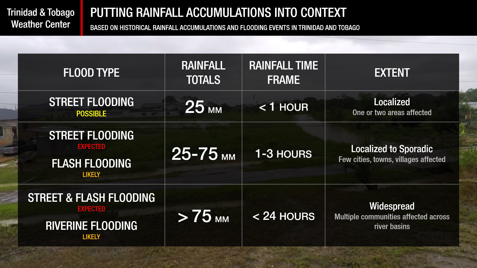
Understanding Rainfall Rates

Understanding Rainfall Accumulations
Putting the rainfall forecast into context, rainfall rates in excess of 50 millimeters per hour or areas that receive in excess of 25 millimeters within an hour tend to trigger street flooding across the country or flash flooding in northern Trinidad. For riverine flooding to occur, a large area of the country (not just in highly localized areas of western coastal Trinidad) would have to record upwards of 75 millimeters within 24 hours, and rainfall would have to fall across major rivers’ catchment areas.
Strong Thunderstorms
Strong ThunderstormsWhat is a strong or severe thunderstorm?
Given how rare these types of thunderstorms are in our region – we classify a severe or strong thunderstorm as one that produces any of the following:
- Damaging wind gusts exceeding 55 KM/H;
- Frequent lightning (more than 30 cloud-to-ground strikes within a 10-minute period);
- Hail (of any size);
- Rainfall of more than 50 millimeters or more within an hour or exceeding 75 millimeters or more within three hours;
- The sighting of a funnel cloud or touchdown of a waterspout/tornado associated with the thunderstorm.
Gusty Winds
Gusty WindsPossible impacts include localized wind damage to trees, power lines, and small structures. Small potted plants may blow over with light outdoor objects, becoming airborne in stronger gusts. Tents may jump.
Other Hazards
Saharan Dust Forecast

Next Saharan Dust Surge Forecast By Mid-Next Week
Why I May Not/Will Not See Rainfall?
A frequent complaint is the forecast is wrong because I didn’t experience any rainfall. Scattered showers mean that you, individually, may experience some showers intermittently throughout the day, and there is a higher chance for this activity than isolated activity. Widespread showers mean that nearly all persons and areas may experience rainfall.
Over the next five days, the highest rainfall chances exist across western coastal areas of Trinidad, and through Monday, also across northern areas of Trinidad. Rainfall is forecast to be isolated.

Forecast Discussion
Tropical Update

Tropical Update: Atlantic Remains Quiet, Tropical Wave To Bring Rainfall To T&T
While the tracks of both Tropical Storm Philippe and Tropical Storm Rina are complex as they interact with each other east of the Lesser Antilles, their influence on Trinidad and Tobago’s atmosphere is fairly straightforward.
As these low-pressure systems meander east of the Leewards, near-surface to low-level winds are forecast to continue moving from the southeast to southwest through Monday. These clockwise (veering) winds, combined with strong daytime heating, sea breeze convergence, and orographic effects, will support conditions favorable for late morning through afternoon thunderstorms. On Monday, both the GFS and ECMWF (two top global models) indicate a plume of moisture from South America will move across T&T towards Tropical Storm Philippe, fuelling shower/thunderstorm activity.
By Tuesday, a high-pressure ridge begins to move in, but our wind regime will still remain fairly light and from the southeast, with veering winds through the atmosphere. While this will support late morning/early afternoon rainfall, drier air is forecast to move in between Tuesday and Wednesday in particular, leading to reduced rainfall chances and cloud cover.
On both Tuesday and Wednesday, very hot temperatures are forecast, where maximum highs could range between 33°C and 37°C. This strong daytime heating, combined with sea breeze convergence, could act as triggers for isolated strong thunderstorms, but forecast models at this time are not enthusiastic about this outcome, leaving T&T mostly sunny and rain-free.
Beyond the forecast period, Tropical Wave 49 is located along 22W and is forecast to move across T&T from late Thursday through Friday next week, bringing showers and thunderstorms.


