Trinidad and Tobago recorded its hottest day for the year to date at both climate reference sites at Piarco and Crown Point. However, late morning through afternoon thunderstorms kept the overall temperatures marginally cooler than the last few days across Trinidad.
Light winds and mostly sunny skies have resulted in hot temperatures being reported across Trinidad and Tobago over the last several days. On Monday, thermometers at Piarco recorded 33.4°C, making it the hottest day for the year at Trinidad’s climate reference site, while at Crown Point, Tobago, the maximum high was 32.4°C, tying with August 5th, 2023, for the hottest day on the island to date.
However, hotter temperatures were recorded across various areas of both islands
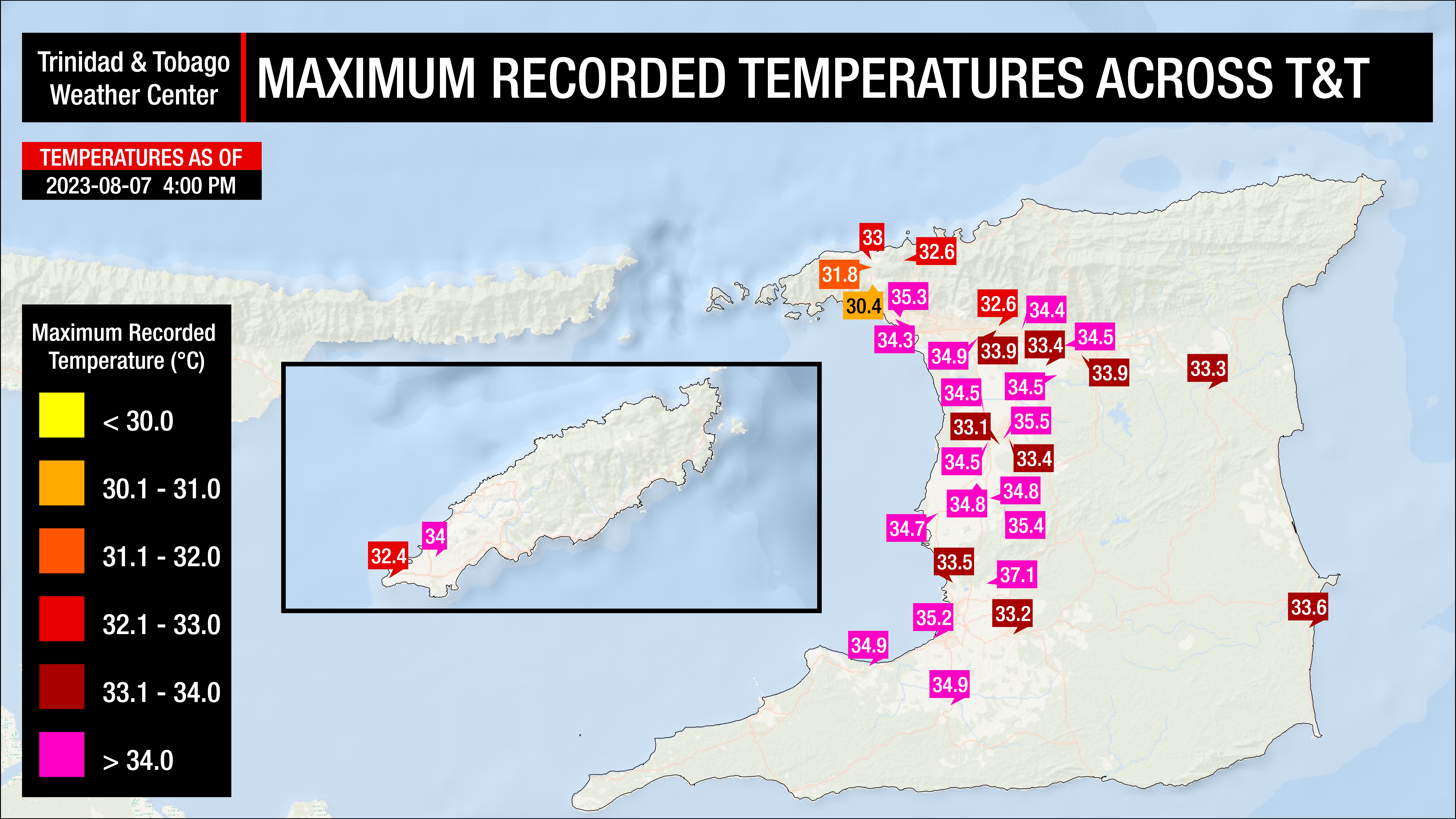
On Monday, across most of the country, temperatures ranged between 33.0°C and 36.0°C, mainly across Trinidad. In urban areas and areas where development is prevalent, temperatures trended higher. Across northwestern Trinidad, cloud cover prevented temperatures from soaring further.
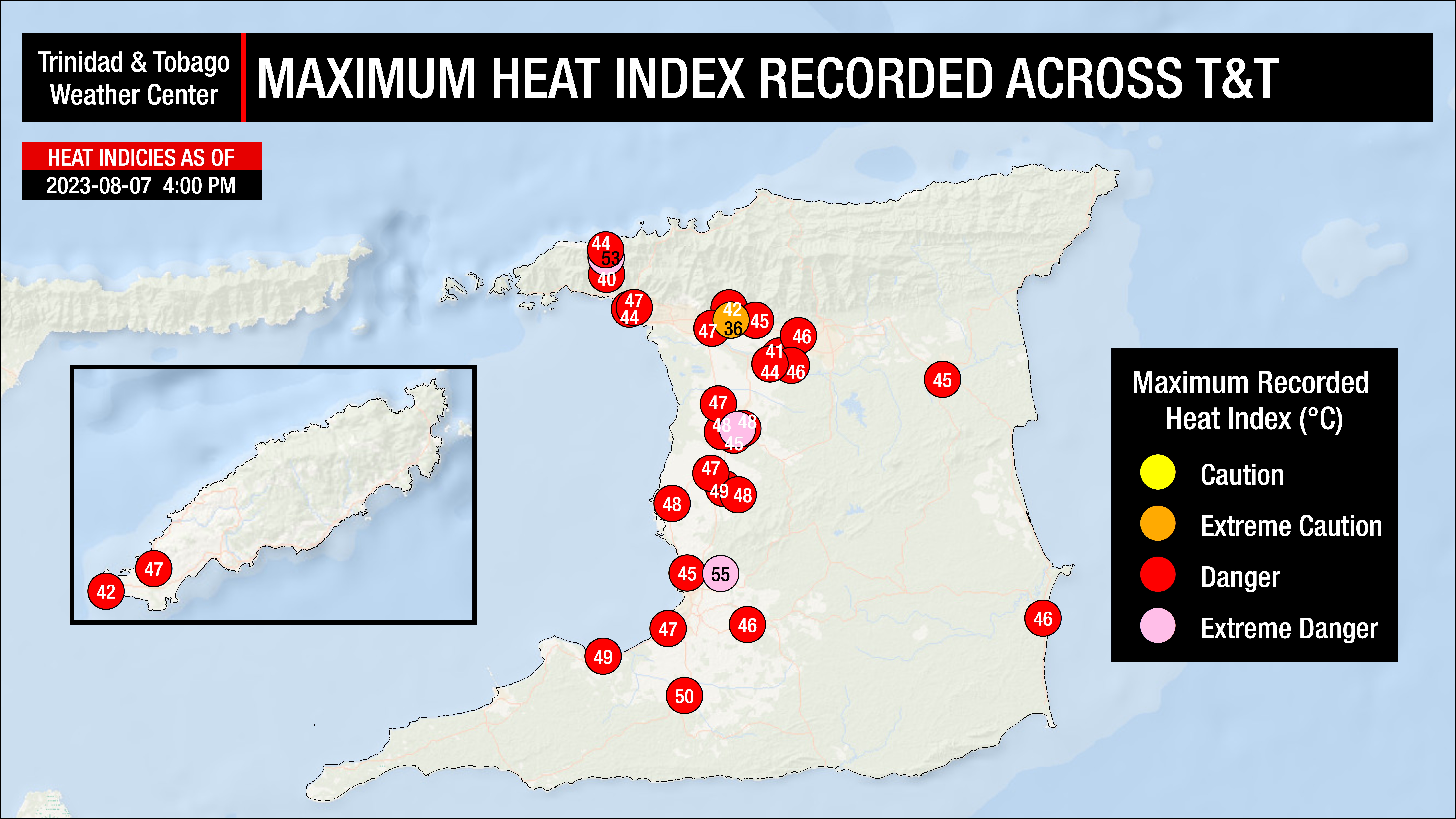
With a tropical wave moving across the region, increasing moisture (humidity) was moving across T&T, causing the heat index to be high, in the dangerous category across much Trinidad and Tobago.
Where do these temperatures stand compared to our records? The hottest recorded temperature for August in Trinidad, according to the Trinidad and Tobago Meteorological Service (1946-2022), stands at 35.8°C recorded on August 23rd, 2017. At Piarco International Airport, the hottest temperature ever was recorded on September 25th, 1990, at 36.5°C.
Hot Temperatures Continue… With A Mid-Week Break
Across both islands, hot conditions are forecast over the next several days. However, an active tropical wave is forecast to move across the country midweek, with increased cloud cover keeping maximum high temperatures on the “cooler” side on Wednesday and possibly on Thursday.
Tuesday
Low: 24-27°C
High: 32-36°C
Wednesday
Low: 24-26°C
High: 29-33°C
Thursday
Low: 25-27°C
High: 30-34°C
Friday
Low: 25-27°C
High: 31-35°C
Saturday
Low: 25-26°C
High: 29-33°C
Over the next five days, maximum high temperatures are forecast to be hot, near 33°C to 34°C at Piarco, trending slightly cooler Wednesday, Thursday, and Saturday, while at Crown Point, maximum high temperatures are forecast to remain near 32°C, with similar cooler weather on Wednesday, Thursday, and Saturday. Generally, higher temperatures are forecast across urbanized areas of Trinidad, particularly on Tuesday, where in built-up areas, maximum high temperatures are likely to exceed 34°C. Minimum lows are forecast to remain mild, ranging between 24°C and 27°C in Trinidad and Tobago, trending marginally cooler in interior areas. The heat index will generally be above 37°C through the forecast period, with exceptions on Wednesday, Thursday, and Saturday.
Temperatures in cities, such as Port of Spain, tend to be much higher than in surrounding locations due to a phenomenon called the Urban Heat Island Effect. There are several causes, but the main instigator for this phenomenon tends to be increased dark surfaces, such as roads and pavement in cities, which absorb solar radiation more than surrounding areas.
The heat index will be between levels that require extreme caution to near dangerous levels over the next five days across Trinidad and Tobago. The heat index is a combination of air temperature and relative humidity, determining what the air feels like to a person, i.e., how hot it actually feels.
Across Trinidad, the maximum heat index is forecast to be between 35°C and 50°C and even higher in urbanized areas. In Tobago, the maximum heat index is forecast to be between 35°C and 42°C.
The heat index is important because of sweating. Your body sweats to cool the skin and maintain a constant, healthy body temperature. This cooling process means that the sweat has to evaporate off the skin to remove heat. However, if the sweat is unable to evaporate, the body isn’t able to regulate temperature.
Is this a heatwave?
Not yet.
Currently, the forecast maximum high temperature is forecast to be between 32.0°C and 34°C at Piarco, Trinidad, and between 31.0°C and 32.5°C at Crown Point, Tobago.
For a hot spell to be declared in Trinidad and Tobago by the Trinidad and Tobago Meteorological Service, a period of hot temperatures, characterized by maximum temperatures of at least 34.0°C in Trinidad and 32.0°C in Tobago, lasting five or more consecutive days. A short-duration hot spell is three or more consecutive hot days.