


The Intertropical Convergence Zone (ITCZ) is forecast to linger near Trinidad and Tobago over the next five days bringing intervals of showers and isolated thunderstorms.
What you need to know
— Saharan Dust: Fluctuating Saharan Dust levels are forecast through the forecast period, with mild to moderate levels.
— Rainfall: Isolated to scattered showers and thunderstorms are forecast over the next five days, but overall heavier rainfall is forecast to remain south and east of the country. Over the next five days, overall rainfall totals between 50 and 100 millimeters of rainfall are forecast across most of the country. However, across the southern, and eastern halves of Trinidad and western coastal areas of Trinidad, isolated totals of up to 125 millimeters of rainfall are possible.
— Hazards: The main hazards are localized street/flash flooding as a result of localized heavy showers and thunderstorms, accompanied by gusty winds up to and in excess of 55 KM/H. The chances for riverine flooding remain low at this time. Lightning will accompany thunderstorms. Landslides are possible across northeastern areas of Trinidad and Tobago.
— Alerts/Watches/Warnings: An Adverse Weather Alert (Yellow Level) went into effect for Trinidad and Tobago from 2:00 AM Wednesday, August 3rd, 2022, and remains in effect through 6:00 PM Wednesday, August 3rd, 2022, from the Trinidad and Tobago Meteorological Service. There are no tropical storm or hurricane watches or warnings in effect for T&T at this time.
The Forecast
Wednesday
WednesdayThursday
ThursdayFriday
FridaySaturday
SaturdaySunday
SundayMarine: Through Sunday, seas are forecast to be slight to moderate, with waves in open waters up between 1.0 and 2.0 meters. In sheltered areas, waves are forecast to be near calm but occasionally choppy in the vicinity of heavy showers/thunderstorms.
Temperatures
Through the forecast period, the minimum low in Trinidad and Tobago is forecast to be between 24.0°C and 26.0°C.
Over the next five days, maximum highs across the country are forecast to be up to 31.0°C in Trinidad and 30.0°C in Tobago, with cooler maximum highs from Wednesday through Friday across both islands due to increased cloud cover. In urbanized areas like Port of Spain, Scarborough, San Fernando, and Chaguanas, the maximum high temperatures could exceed 34.0°C on Saturday and Sunday.
Forecast Impacts
Flooding
FloodingThere is a high chance of street and flash flooding, particularly across the southern and eastern halves of Trinidad as well as eastern Tobago. Chances for riverine flooding remain low as major rivers across the country are well within their banks.
Forecast Rainfall Totals
- Wednesday: Between 15 and 45 millimeters of rainfall across both islands, trending higher across eastern and southern areas of Trinidad and Tobago, as well as along western coastal Trinidad. Isolated totals may accumulate up to 100 millimeters favoring the eastern half of Trinidad.
- Thursday: Between 15 and 25 millimeters of rainfall across both islands, trending higher across southern, eastern, and western coastal Trinidad with isolated totals up to 50 millimeters.
- Friday: Between 10 and 25 millimeters of rainfall across the country, trending higher across southern, eastern, and western coastal Trinidad with isolated totals up to 35 millimeters.
- Saturday: Less than 15 millimeters across the country, with higher rainfall totals favoring southern and western coastal areas of Trinidad.
- Sunday: Less than 10 millimeters across the country, with higher rainfall totals favoring southern and western coastal areas of Trinidad.
Putting the rainfall forecast into context, rainfall rates in excess of 50 millimeters per hour or areas that receive in excess of 25 millimeters within an hour tend to trigger street flooding across the country or flash flooding in northern Trinidad. For riverine flooding to occur, a large area of the country (not just in highly localized areas of western coastal Trinidad) would have to record upwards of 75 millimeters within 24 hours, and rainfall would have to fall across major rivers’ catchment areas.
Strong Thunderstorms
Strong ThunderstormsThe chances of strong thunderstorms are low to medium, but activity will be short-lived. Funnel cloud development is possible through the next five days due to near calm to light and variable winds. The highest chances for funnel cloud/waterspout development exist along western coastal areas of both Trinidad and Tobago, as well as along southern and eastern coastal areas of Trinidad. If a funnel cloud touches down on a body of water, it becomes a waterspout; if it touches down on land, it becomes a tornado.
While abundant frequent cloud-to-ground lightning isn’t likely, lightning is expected in thunderstorm activity.
Gusty Winds
Gusty WindsWith wind gusts up to and in excess of 55 KM/H, whole trees are expected to be in motion, and there may be some inconvenience when walking against the wind gusts. Light outdoor objects may topple or become airborne such as garbage cans, potted plants, loose galvanize or construction material, and other outdoor furniture. Tents may jump. Older/weaker trees may fall, bringing down utility poles and lines.
Other Hazards
Saharan Dust will fluctuate over the next five days, occasionally reducing air quality and affecting visibility.
Why I May Not/Will Not See Rainfall?
A frequent complaint is the forecast is wrong because I didn’t experience any rainfall. Scattered showers mean that you, individually, may experience some showers intermittently throughout the day, and there is a higher chance for this activity than isolated activity. Widespread showers mean that nearly all persons and areas may experience rainfall.
Isolated to scattered showers and thunderstorms on Wednesday into Thursday and on Friday into Saturday.

Forecast Discussion
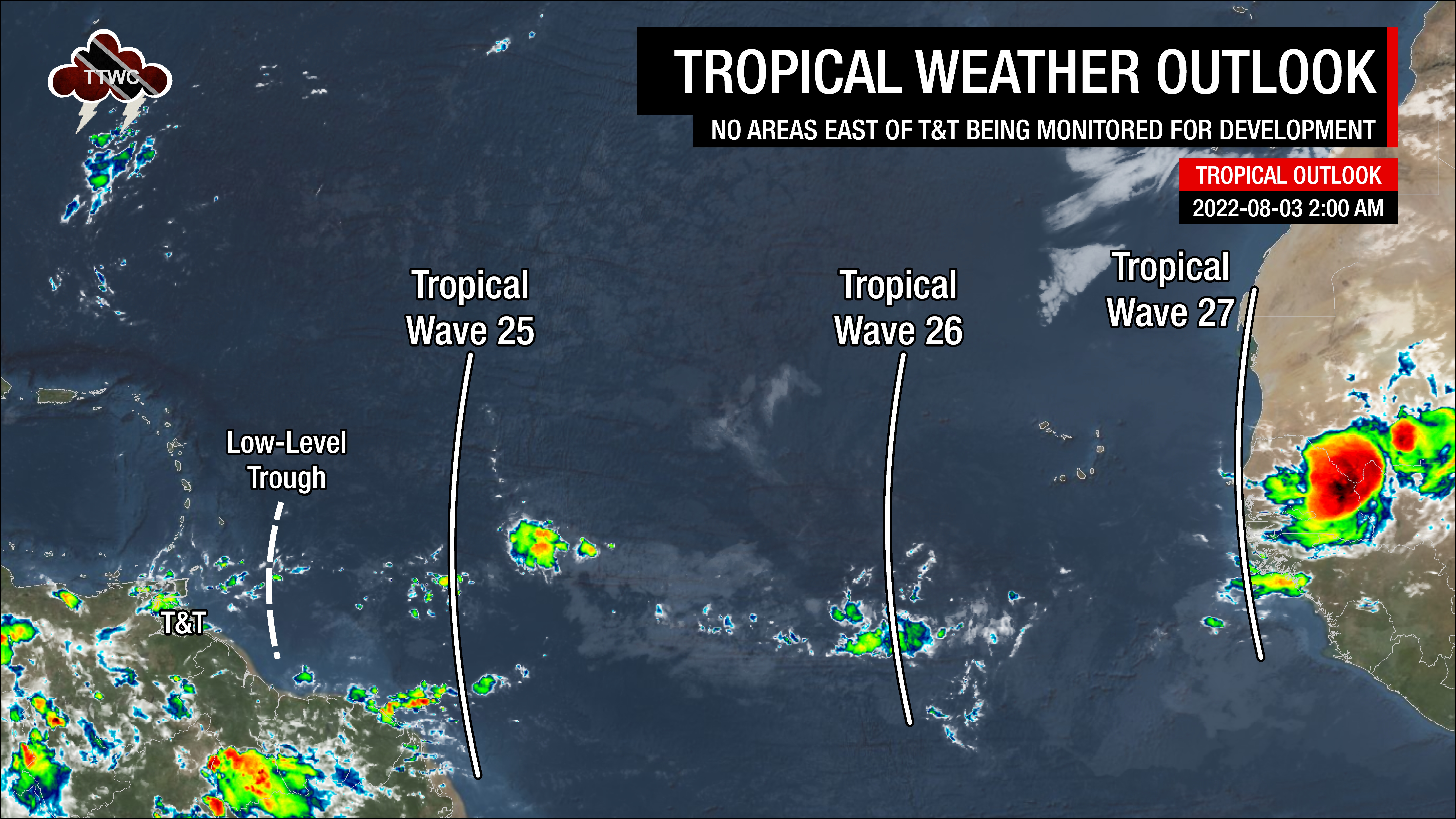
Tropical Waves (and other features) East of T&T: Based on the Tropical Analysis and Forecast Branch’s 00Z surface analysis on August 3rd, 2022, as well as the latest satellite and model guidance:
- A low-level trough is located approximately 445 KM east of Trinidad and Tobago, forecast to move across the country on Wednesday morning into the afternoon, interacting with the ITCZ.
- The 25th tropical wave for 2022 (TW25) is along 50°W, south of 20°N, moving west at 15 knots (28 KM/H). Scattered weak to moderate pockets of convection are noted near the wave, with stronger activity suppressed due to abundant Saharan Dust. Forecast models indicate this tropical wave will move across the Lesser Antilles by late Thursday into Friday.
- The 26th tropical wave for 2022 (TW26) is along 31°W, south of 25°N, moving west at 15-20 knots (28-37 KM/H). An elongated circulation is centered along the wave axis at 15°N, 30°W. Scattered moderate convection has been observed where the wave axis interacts with the Monsoon Trough. This tropical wave is forecast to move across the region in two parts. The northern portion of the wave and its associated moisture are forecast to move across the Northern Windwards and Leewards by early Saturday, while the southern portion of the wave axis moves across the remainder of the Windwards on Sunday into Monday.
- The 27th tropical wave for 2022 (TW27) is along 17°W, south of 24°N, moving west at 10 knots (18 KM/H). Strong convection remains on land across western Africa. This wave is forecast to move across the Lesser Antilles by next Tuesday.
On Tuesday, a dry and stable mid- to upper-level environment was present across Trinidad, Tobago, and the Southern Windwards Islands as a surface to low-level ridge remained dominant with abundant Saharan Dust. However, by the afternoon, total atmospheric moisture was on the increase across both islands as the Intertropical Convergence Zone (ITCZ) nears. Few low-level cloud patches moved across T&T, bringing brief showers.
By mid-Wednesday, increasing deep-layered moisture is forecast to move across both islands associated with the ITCZ and a low-level trough with very favorable mid- to upper-level conditions and light to moderate westerly wind shear. These conditions are forecast to support isolated to scattered showers and thunderstorms, with low-level conditions becoming more favorable as the low-level trough moves across the region by Wednesday afternoon.
Wind shear is forecast to increase on Thursday with a dry intrusion of air at mid-levels, which may limit persisting shower and thunderstorm activity. However, with deep-layered moisture and moderate instability present due to the ITCZ lingering, variably cloudy conditions with showers and thunderstorms remain in the forecast.
On Friday, conditions are forecast to become increasingly favorable for showers and isolated thunderstorms as TW25 nears and moves across T&T by early Friday. High precipitable water levels with a marginally favorable low to mid-level environment may support isolated heavy showers or brief, stronger thunderstorms that move in from the Atlantic.
By late Saturday, as TW25 moves west, a marginally drier atmosphere with moderate shear is forecast to move in across the country. However, sufficient moisture and light low-level winds are forecast to allow localized climatic effects (daytime heating, sea breeze convergence, and orographic effects) to act as triggers for late morning through afternoon showers and isolated thunderstorms favoring western and hilly areas.
TW26 will bring another surge of moisture to the area by Sunday afternoon into the night across Trinidad and Tobago, but pockets of dry air could intrude and limit shower/thunderstorm development.
Over the five-day forecast period, Saharan Dust is forecast to be present at mild to moderate levels. Numerical weather prediction models tend to have a poor handle on dry air intrusions from Saharan Dust, which results in an overproduction of modeled showers, thunderstorms, and rainfall accumulations.


