


Heavy showers and thunderstorms are affecting Trinidad and Tobago on Wednesday, associated with an active Intertropical Convergence Zone (ITCZ) and a low-level trough. Heavier activity is forecast to remain south and east of Trinidad and Tobago.
What you need to know
— Rainfall: Through the next 6-12 hours, areas of rain, moderate to heavy showers, and isolated thunderstorms are forecast, interrupting variably cloudy skies. Peak intense activity, including isolated heavy to violent showers and intense thunderstorms, is forecast from the early morning through the afternoon, gradually settling by the evening. Overall rainfall totals between 15 and 45 millimeters are forecast across both islands, trending higher across eastern and southern areas of Trinidad and Tobago, as well as along western coastal Trinidad. Isolated totals may accumulate up to 100 millimeters, particularly across the eastern half of Trinidad.
— Hazards: Chances for street/flash flooding are high on Wednesday. Chances for riverine flooding remain low. Gusty winds in excess of 45 KM/H accompanying heavy showers or thunderstorms are likely, with wind gusts in excess of 55 KM/H possible. Lightning will accompany thunderstorms. Landslides are possible across northeastern areas of Trinidad and Tobago.
— Alerts/Watches/Warnings: An Adverse Weather Alert (Yellow Level) went into effect for Trinidad and Tobago from 2:00 AM Wednesday, August 3rd, 2022, and remains in effect through 6:00 PM Wednesday, August 3rd, 2022, from the Trinidad and Tobago Meteorological Service. There are no tropical storm or hurricane watches or warnings in effect for T&T at this time.
The Adverse Weather Alert
The Trinidad and Tobago Meteorological Service has updated an Adverse Weather Alert (Yellow Level) on Wednesday at 8:56 AM. The alert went into effect at 2:00 AM Wednesday, August 3rd, 2022, and remains in effect through 6:00 PM Wednesday, August 3rd, 2022.
Trinidad and Tobago is not under any tropical storm watch or warning at this time.
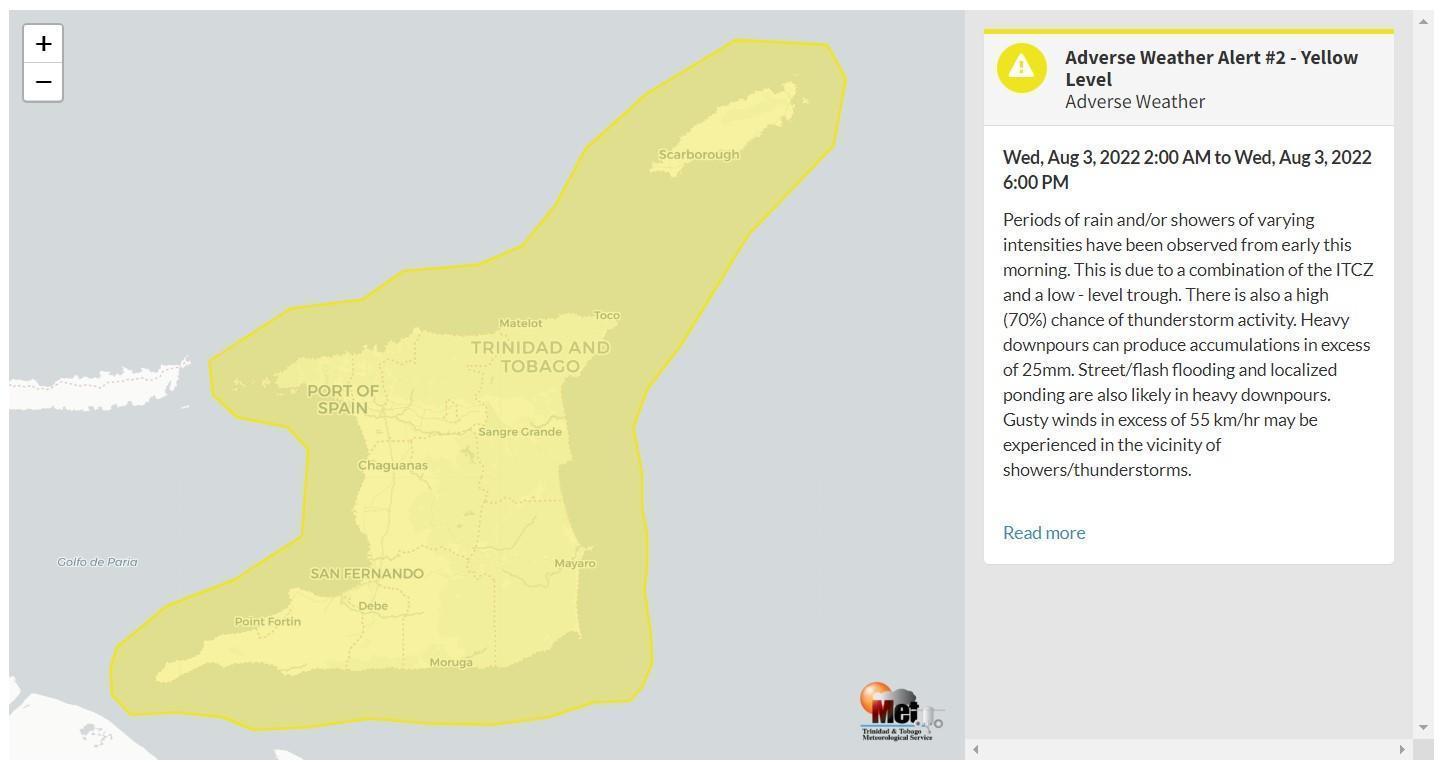
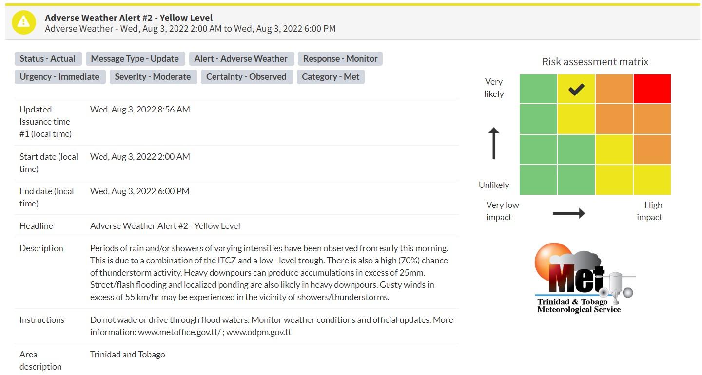
“Periods of rain and/or showers of varying intensities have been observed from early this morning. This is due to a combination of the ITCZ and a low-level trough. There is also a high (70%) chance of thunderstorm activity. Heavy downpours can produce accumulations in excess of 25mm. Street/flash flooding and localized ponding are also likely in heavy downpours. Gusty winds in excess of 55 km/hr may be experienced in the vicinity of showers/thunderstorms.” according to the Trinidad and Tobago Meteorological Service. This “alert” status takes into account the possibility of the event occurring. This adverse weather event has been observed.

The color of the alert indicates the severity of the event and the probability of the event occurring. Currently, the alert level is Yellow. This means that the hazards have been observed, but the severity of impacts is moderate for this particular alert. You should be aware of the hazards in your area associated mainly with gusty winds in excess of 55 KM/H, street and flash flooding, as well as frequent lightning.
For a moderate Adverse Weather Alert, there is the potential for possible injuries, where behavioral changes are required to ensure safety. There may be minor damage to property, with income-earning temporarily disrupted and a couple of communities affected.
The Met Office is advising the public not to venture into floodwaters as well as monitor weather conditions and updates from official sources.


