


Multiple weather features are forecast to affect T&T over the next five days but the wettest period is forecast over the next 48 hours, associated with Tropical Wave 13/14. There is an elevated risk of street/flash flooding and landslides following this week of rainfall.
What you need to know
— Saharan Dust: Following Tropical Wave 13/14, a Saharan Dust surge is forecast to affect T&T from late Saturday night at fluctuating concentrations through the upcoming week.
— Rainfall: While the wettest day is forecast on Friday, intermittent showers and thunderstorms are forecast through the next five days. Tropical Wave 13/14, Tropical Wave 15, a low-level trough, and the Intertropical Convergence Zone are all forecast to impact T&T in some form or fashion through Tuesday.
— Hazards: The main hazards remain street/flash flooding, landslides in elevated areas, particularly across northern Trinidad, and gusty winds (up to and in excess of 45 KM/H) accompanying heavy showers or thunderstorms. The chances for riverine flooding remain low at this time, though close attention should be paid to the Caroni and South Oropouche River Basins. Lightning will accompany thunderstorms.
— Alerts/Watches/Warnings: Trinidad and Tobago is under an Adverse Weather Alert (Yellow Level) from the Trinidad and Tobago Meteorological Service from 5:00 AM Friday, July 1st, 2022 to 5:00 PM Friday, July 1st, 2022. There are also no tropical storm or hurricane watches or warnings in effect for T&T.
The Forecast
Thursday Night
Thursday NightFriday – Tropical Wave 13/14
Friday – Tropical Wave 13/14Saturday – Tropical Wave 13/14
Saturday – Tropical Wave 13/14Sunday – Trough, ITCZ Nearby
Sunday – Trough, ITCZ NearbyMonday – ITCZ Nearby
Monday – ITCZ NearbyTuesday – Tropical Wave 15
Tuesday – Tropical Wave 15Marine: Seas are forecast to be moderate with waves in open waters up to 2.0 meters, while in sheltered areas, waves are forecast to be below 1.0 meter, and near calm at times on Friday into Saturday.
Temperatures
Through the forecast period, the minimum low in Trinidad and Tobago is forecast to be between 24.0°C and 26.0°C.
Maximum highs across the country are forecast to be generally up to 32.0°C in Trinidad and Tobago. In urbanized areas like Port of Spain, Scarborough, San Fernando, and Chaguanas, the maximum high temperatures could exceed 30.0°C.
Over the next five days, temperatures are forecast to be cooler due to increased cloud cover and anticipated rainfall.
Forecast Impacts
Flooding
FloodingThere is a high chance of street and flash flooding. Chances for riverine flooding remain low to medium as major rivers across the country are elevated but remain within their banks. Close attention should be paid to the Caroni River Basin and South Oropouche River Basin.
Forecast Rainfall Totals
- Friday: Between 5 and 15 millimeters across the country, trending higher across northern and western areas of Trinidad and across Tobago with totals up to and in excess of 35 millimeters. In highly isolated areas, upwards of 35 millimeters are possible, favoring eastern Trinidad and Tobago.
- Saturday: Between 5 and 15 millimeters across the country, trending higher across eastern Trinidad with isolated totals up to 25 millimeters.
- Sunday: Between zero and 10 millimeters across the country, trending higher across southeastern areas of Trinidad with totals up to and in excess of 15 millimeters. In highly isolated areas, upwards of 15 millimeters are possible, particularly during thunderstorm activity.
- Monday: Between zero and 10 millimeters across the country, trending higher across southeastern and northwestern areas of Trinidad with totals up to and in excess of 15 millimeters. In highly isolated areas, upwards of 15 millimeters are possible, particularly during thunderstorm activity.
- Tuesday (through midnight): Between 5 and 15 millimeters across the country, trending higher across southern and eastern areas of Trinidad and across Tobago with totals up to and in excess of 20 millimeters. In highly isolated areas, upwards of 20 millimeters are possible.
Putting the rainfall forecast into context, rainfall rates in excess of 50 millimeters per hour or areas that receive in excess of 25 millimeters within an hour tend to trigger street flooding across the country or flash flooding in northern Trinidad. For riverine flooding to occur, a large area of the country (not just in highly localized areas of western coastal Trinidad) would have to record upwards of 75 millimeters within 24 hours, and rainfall would have to fall across major rivers’ catchment areas.
Strong Thunderstorms
Strong ThunderstormsWith minimal to no wind shear, a highly moist atmosphere, and light low-level winds, there is a low to medium chance of a strong thunderstorm on Friday. Funnel cloud development is possible, particularly on Friday. If a funnel cloud touches down on a body of water, it becomes a waterspout; if it touches down on land, it becomes a tornado. Frequent cloud-to-ground lightning will be possible in thunderstorm activity.
Increasing wind shear and a drier mid-level environment are forecast to limit strong thunderstorm development by Saturday and the weekend into next week.
Gusty Winds
Gusty WindsWith wind gusts up to and in excess of 45 KM/H, whole trees are expected to be in motion, and there may be some inconvenience when walking against the wind gusts. Light outdoor objects may topple or become airborne such as garbage cans, potted plants, loose galvanize or construction material, and other outdoor furniture. Tents may jump. Older/weaker trees may fall, bringing down utility poles and lines.
Other Hazards
Saharan Dust will increase on Saturday, reducing air quality and affecting visibility.
Why I May Not/Will Not See Rainfall?
A frequent complaint is the forecast is wrong because I didn’t experience any rainfall. Scattered showers mean that you, individually, may experience some showers intermittently throughout the day, and there is a higher chance for this activity than isolated activity. Widespread showers mean that nearly all persons and areas may experience rainfall.
Isolated to scattered rainfall is forecast over the next five days.

Forecast Discussion
Tropical Waves East of T&T: Based on the Tropical Analysis and Forecast Branch’s 18Z surface analysis on June 30th, 2022, as well as the latest satellite and model guidance:
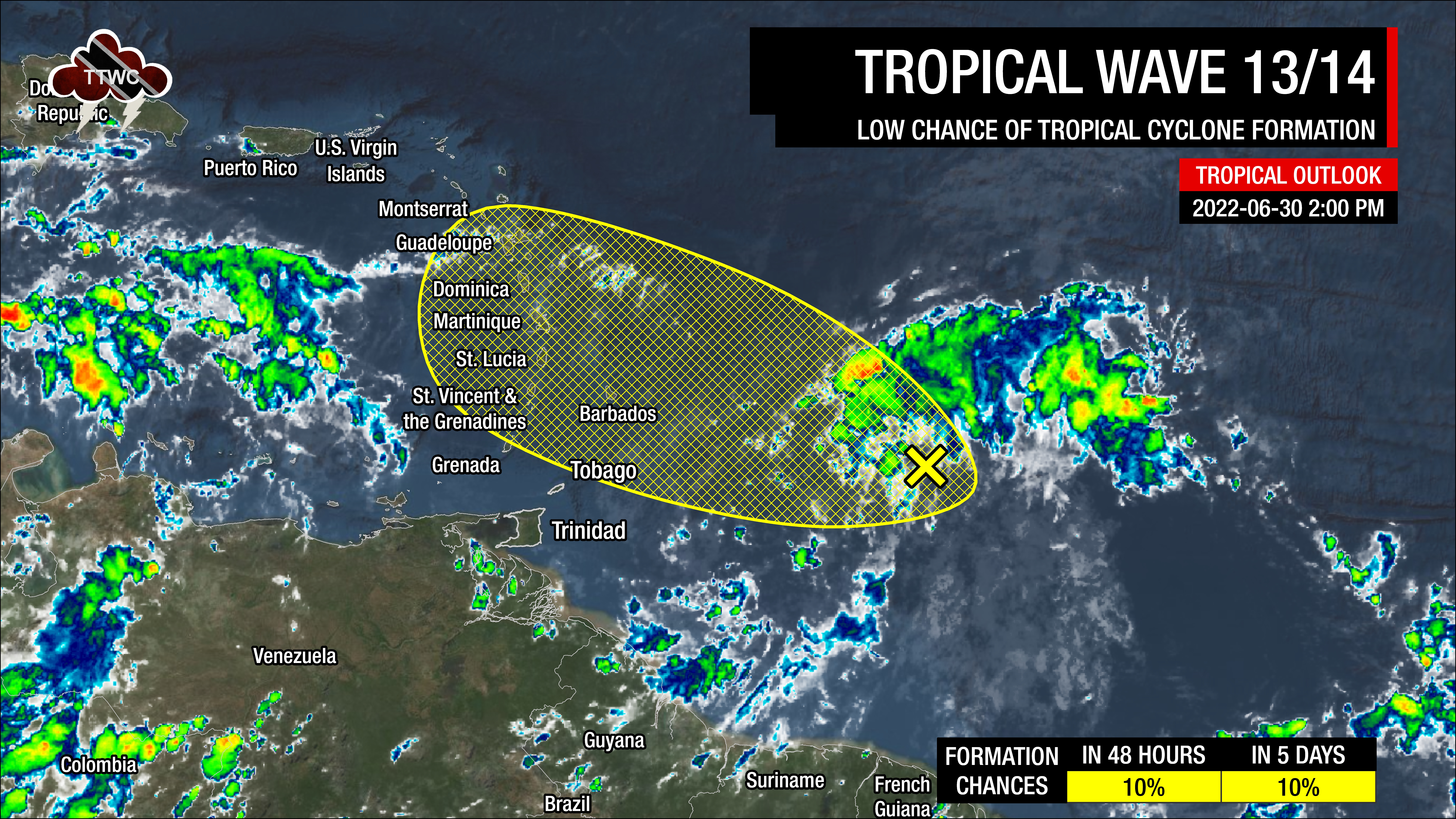
- The 13th tropical wave for 2022 (TW13) and 14th tropical wave for 2022 (TW14) have merged in the Tropical Atlantic, as TW13 slowed while TW14 caught up. The combined tropical wave is along 55°W, south of 17°N, moving west at 10 to 15 knots (18-27 KM/H). This wave is forecast to move across Trinidad and Tobago and the remainder of the Lesser Antilles on Friday night into Saturday, with its moisture field moving across T&T from tonight (Thursday night). Scattered moderate convection is ongoing. As of the 2:00 PM Tropical Weather Outlook from the National Hurricane Center, an area of low pressure centered at 11°N, 53°W has a low chance of development over the next 48 hours and five days. Regardless of development, heavy rainfall and gusty winds will likely affect countries in the central and northern Lesser Antilles on Friday into Saturday.
- The 15th tropical wave for 2022 (TW15) is along 28°W, south of 18°N, moving west at 10-15 knots (18-27 KM/H). This wave is forecast to move across Trinidad and Tobago on Tuesday, July 5th, 2022. Few showers are observed near the wave axis.
Two tropical waves have merged into one in the Tropical Atlantic Ocean, and the combined wave is currently under favorable upper-level divergence and low-level convergence. This wave is forecast to move into an area of unfavorable westerly to southwesterly shear, which will limit any development. Closer to Trinidad and Tobago, little to no wind shear is in place, and similar conditions will remain through Friday, allowing for deeper, slow-moving convection (showers and thunderstorms) to develop.
Deep, tropical moisture associated with this wave has begun to move across Trinidad and Tobago on Thursday evening, with moisture levels increasing across the country through the next several days. Forecast models indicate high precipitable water (atmospheric moisture) across T&T through the next five days as the Intertropical Convergence Zone remains near the country, meandering north and south of T&T.
A weak low-level trough is forecast to develop south of T&T on Saturday into Sunday, increasing unstable conditions.
However, there will be limiting factors in place. Wind shear will be light to moderate from Saturday through early Tuesday, limiting persisting convection. On Tuesday, as Tropical Wave 15 moves across T&T, wind shear is set to decrease again, allowing for persisting showers and thunderstorms. Overarching through the forecast period will be the presence of Saharan Dust, which will cause drier mid to low levels of the atmosphere and limit convection, leading to cloudy but hazy skies.


