


Multiple weather features are forecast to affect T&T over the next five days but the wettest period is forecast over the next 48 hours, associated with Tropical Wave 13/14.
What you need to know
— Rainfall: Between 5 and 15 millimeters across the country, trending higher across northern and western areas of Trinidad and across Tobago with totals up to and in excess of 35 millimeters. In highly isolated areas, upwards of 35 millimeters are possible, favoring eastern Trinidad and Tobago. This rainfall is associated with Tropical Wave 13/14 (merged) and the Intertropical Convergence Zone.
— Hazards: The main hazards remain street/flash flooding, landslides in elevated areas, particularly across northern Trinidad, and gusty winds (up to and in excess of 45 KM/H) accompanying heavy showers or thunderstorms. The chances for riverine flooding remain low at this time, though close attention should be paid to the Caroni and South Oropouche River Basins. Lightning will accompany thunderstorms.
— Alerts/Watches/Warnings: Trinidad and Tobago is under an Adverse Weather Alert (Yellow Level) from the Trinidad and Tobago Meteorological Service from 5:00 AM Friday, July 1st, 2022 to 5:00 PM Friday, July 1st, 2022. There are also no tropical storm or hurricane watches or warnings in effect for T&T.
The Adverse Weather Alert
The Trinidad and Tobago Meteorological Service has issued an Adverse Weather Alert (Yellow Level) on Thursday night at 9:38 PM. The alert goes into effect at 5:00 AM Friday, July 1st, 2022 to 5:00 PM Friday, July 1st, 2022.
Trinidad and Tobago is not under any tropical storm watch or warning at this time.
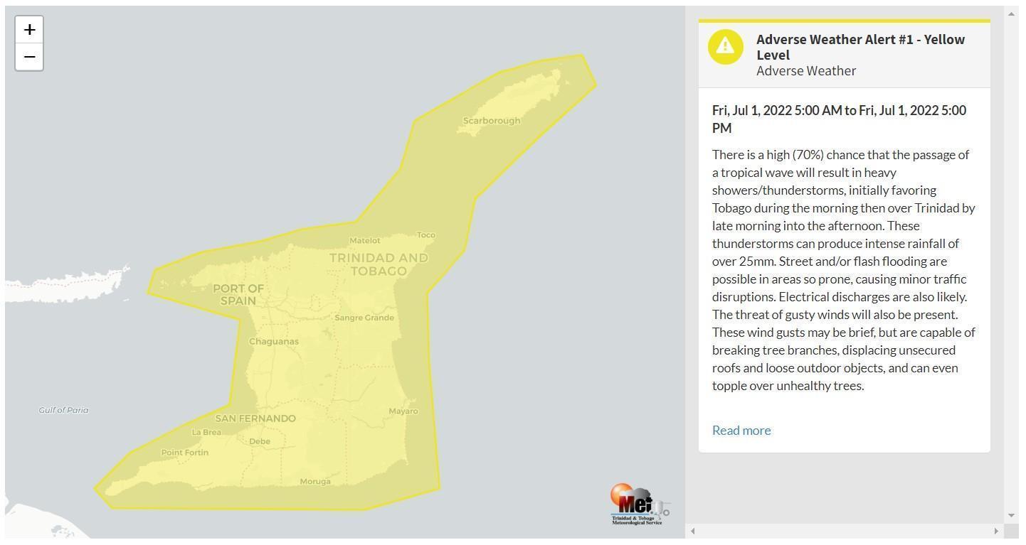
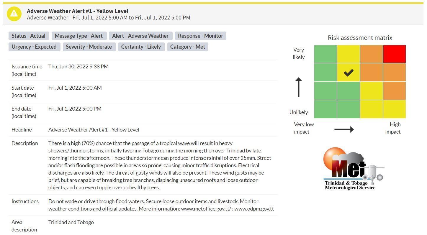
“There is a high (70%) chance that the passage of a tropical wave will result in heavy showers/thunderstorms, initially favoring Tobago during the morning then over Trinidad by late morning into the afternoon. These thunderstorms can produce intense rainfall of over 25mm. Street and/or flash flooding are possible in areas so prone, causing minor traffic disruptions. Electrical discharges are also likely. The threat of gusty winds will also be present. These wind gusts may be brief, but are capable of breaking tree branches, displacing unsecured roofs and loose outdoor objects, and can even topple over unhealthy trees.” according to the Trinidad and Tobago Meteorological Service. This “alert” status takes into account the possibility of the event occurring. This adverse weather event is likely.

The color of the alert indicates the severity of the event and the probability of the event occurring. Currently, the alert level is Yellow. This means that the hazards are likely, but the severity of impacts is moderate for this particular alert. You should be aware of the hazards in your area associated mainly with gusty winds in excess of 45 KM/H, street, and flash flooding as well as frequent lightning.
For a moderate Adverse Weather Alert, there is the potential for possible injuries, where behavioral changes are required to ensure safety. There may be minor damage to property, with income-earning temporarily disrupted and a couple of communities affected.
The Met Office is advising the public to be alert for cloud-to-ground lightning activity and not venture into floodwaters, secure loose objects outdoors as well as monitor weather conditions and updates from official sources.


