Temperatures across Trinidad and Tobago reached their lowest for 2026 on Sunday morning, with several areas reporting minimum temperatures below 19°C.
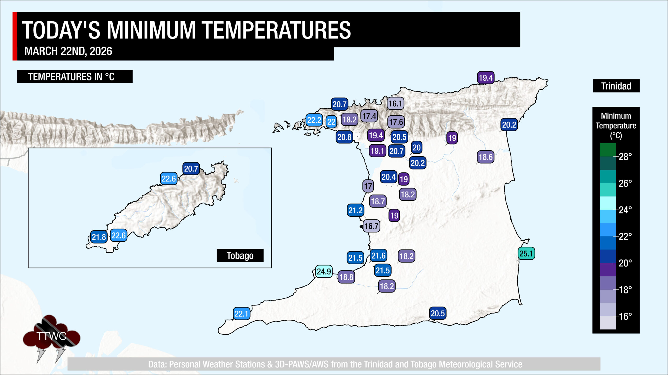
Across interior areas of Trinidad, valleys and mountaintops, temperatures ranged from as low as 16.1°C at the peak of El Tucuche, to as high as 25.1°C along the east coast of Trinidad.
A minimum of 20.0°C was recorded at Piarco and 21.8°C at Crown Point. These temperatures are now the coolest official nighttime lows recorded for 2026 to date, beating the records set yesterday and the day prior.
Is this record-breaking?
According to the Trinidad and Tobago Meteorological Service, the coolest minimum low recorded at Piarco in March was 17.2°C on March 2nd, 1962. However, the TTMS has recorded even lower temperatures in the past. The lowest minimum temperature on record at Piarco is 16.1°C, which occurred on the nights of January 21st and 30th, 1964.
Temperature records elsewhere, like Penal, Brasso, Caroni, and El Reposo in Sangre Grande, where both automated weather stations exist, and cooler temperatures than Piarco are usually recorded, have not been recorded as long as those in Piarco.
For T&T, the climate reference sites are Piarco in Trinidad, where records have been kept since 1946, and Crown Point in Tobago, where records have been kept since 1969.
What’s causing these cool temperatures?
T&T has seen an unusual stretch of near-record-breaking dry air move across the area over the last three days, allowing for clear, sunny, and warm days and equally clear, cool nights. As a result, many areas across the country have recorded temperatures below 20°C for three nights in a row, with an automated weather station at the peak of El Tucuche, Trinidad’s second-highest peak, even recording a low of 15.4°C.
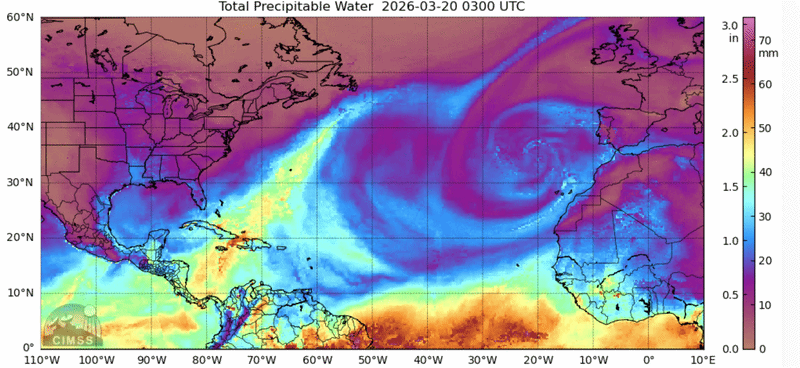
Over the last several days, an Atlantic high-pressure system remained in place across the region, including Trinidad and Tobago, channeling cooler, drier air into the area. This initial air mass inhibited cloud formation at night, with little moisture (water vapor), allowing heat to escape from the ground.
This dry and cool airmass has been traced back to originating over the North Atlantic and moving down to the Caribbean due to atmospheric circulation over the Atlantic Ocean – namely, the persistent high-pressure system in the North Atlantic.
While moisture and temperature increased on its journey to T&T, the conditions remained dry and stable enough to hinder clouds’ development. Situations like these are not frequent, but they tend to occur several times during our dry season.
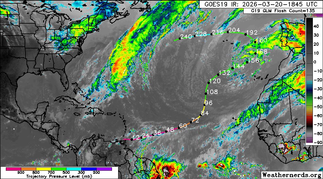
Winds also play a role, with wind speeds dramatically decreasing over the past seven days across the area due to a combination of a weakening cold front in the western Caribbean Sea and a developing low-level trough that moved across the central and northern Windwards over the weekend, north of T&T.
Cool temperatures across Trinidad result from several factors occurring:
- Low amounts of low-level moisture (water vapor/relative humidity/dew point);
- Calm/near-calm winds;
- Little to no cloud coverage;
- Winds originating from the northeast to the north at the lower levels of the atmosphere;
The dew point is the atmospheric temperature below which water droplets begin to condense, and dew can form. Meteorologists can determine the moisture content of the atmosphere near the surface and estimate the minimum temperature. A lower dew point means that there is less water vapor in the air. Water vapor can absorb and radiate heat back to the surface. Hence, the lower the dew point, the more infrared radiation (i.e., long-wave radiation) can escape from the Earth’s surface, leading to rapid cooling. The dew point also sets the floor for how cool the actual temperature can get – any cooler and dew/mist/fog develops. With this period of cooler temperatures across T&T, dew point values dropped as low as 12.7°C
Forecast Into The Week
Elevated low-level moisture is set to return to Trinidad and Tobago this week, embedded within the flow of the ever-present North Atlantic high-pressure ridge, reducing the likelihood of minimum temperatures falling below 20°C across the country.
However, this moisture and favorable low-level convergence/confluence associated with an induced low-level trough may fuel isolated showers and periods of cloudiness, favoring Tobago on Monday and both islands on Tuesday. Overall, heavier rainfall is forecast to remain offshore eastern T&T.
Minimum lows are likely to range between 21°C and 25°C, trending warmer along the coasts and cooler across the interior of Trinidad, including valleys and mountaintops. Maximum highs are set to peak between 30°C and 33°C, trending higher across urbanized and built-up areas.