


What you need to know
— What: Long-period swells up to 15 seconds are forecast to produce large, breaking waves. In addition, spring tides through October 24th will enhance wave heights during high tide. Lastly, increased winds in heavy showers/thunderstorms are likely to lead to locally choppy/rough seas.
— Where: Swells are expected first to impact Tobago’s northern and northeastern coastlines, then Trinidad’s northern and northeastern coastlines. To a lesser extent, north-facing coastlines of the Gulf of Paria may be affected by these swells from Saturday evening. Locally choppy/locally rough seas are likely across the entire marine area in heavy showers and thunderstorms.
— When: Peak long-period swells up to 15 seconds are forecast between Friday night and Saturday night, with swell periods between 12-13 seconds through Sunday morning. Another swell event is forecast from mid-Monday into Tuesday, outside the TTMS’ alert period, with peak swells up to 15 seconds.
— Impacts: Agitated seas with exacerbated conditions at high tides, larger-than-normal breakers with large, battering waves in the surf zone; disruption of near-shore activities, including fishing, swimming, and boat moorings; coastal flooding with intrusion of salt water, and displacement of sand, further than the average reach point, and elevated risk of rip currents, particularly along northern and eastern beaches.
— What Should You Do: All marine interests need to exercise extreme caution, while small craft operators should seek safe harbor. Inexperienced mariners should avoid navigating in hazardous conditions, especially those operating smaller vessels. Inexperienced swimmers should remain out of the water due to unsafe surf conditions. If you intend to go into the water, it is recommended that you use beaches with on-duty lifeguards. Restrict nearshore marine activities. Secure coastal property and objects on the beachfront that the wave action or winds may sweep away.
Latest Alerts

Localized Flood Alert Discontinued For Trinidad
Trinidad and Tobago is NOT under any tropical storm or hurricane threat, watch, or warning at this time.
Seas Forecast For Trinidad and Tobago
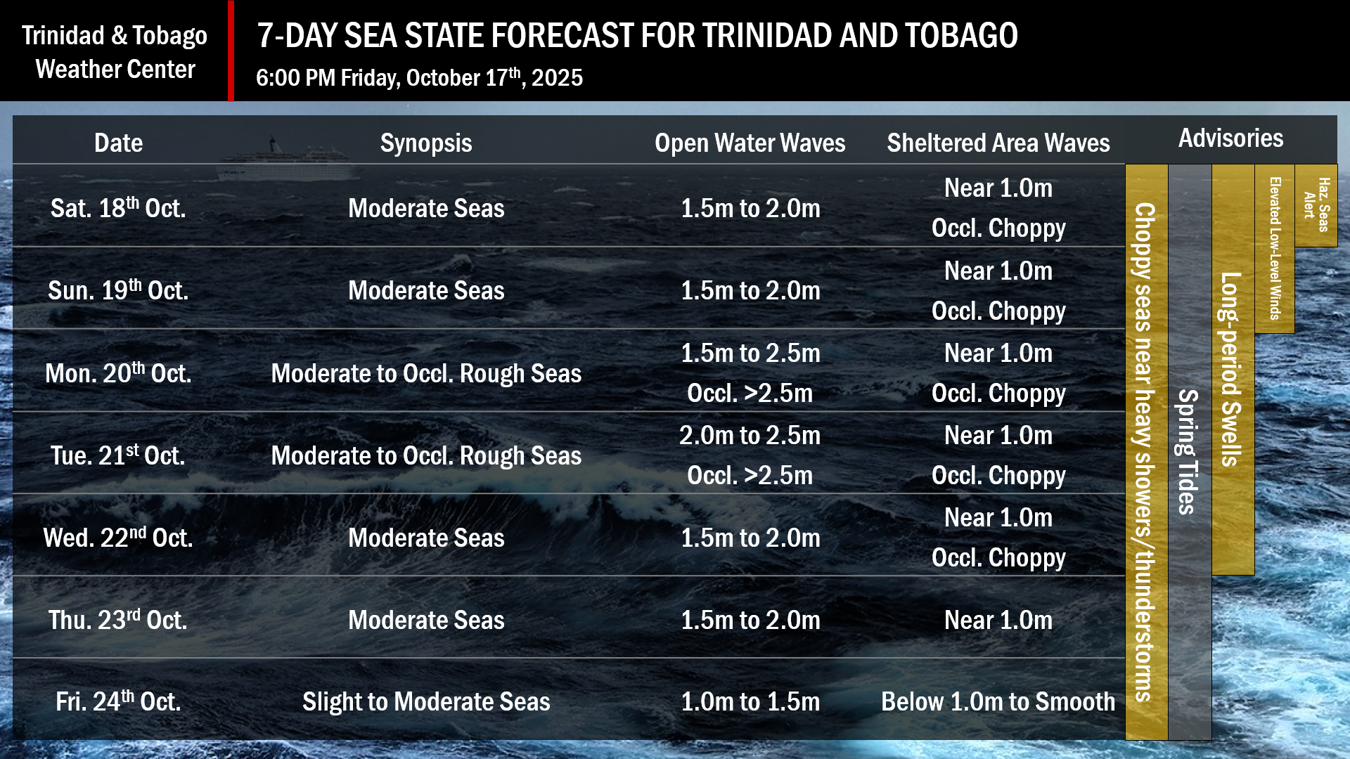
Over the next seven days, Spring tides are forecast. Swell periods from October 18th to October 22nd are forecast to range from 10 to 15 seconds.
October 18th: Winds are forecast to range between 15 and 20 knots from the southeast to northeast. Wind gusts up to 30 knots are possible in heavy showers and thunderstorms. Seas in open waters are forecast to be moderate, with waves between 1.5 and 2.0 meters. In sheltered areas, waves are forecast to be near 1 meter, with choppy conditions in heavy showers and thunderstorms, and higher wave heights along northern and eastern coastlines.
October 19th: Winds are forecast to range between 5 and 15 knots from the south to east-northeast. Wind gusts up to 25 knots are possible in heavy showers and thunderstorms. Seas in open waters are forecast to be moderate, with waves between 1.5 and 2.0 meters. In sheltered areas, waves are forecast to be near 1 meter, with choppy conditions in heavy showers and thunderstorms, and higher wave heights along northern and eastern coastlines.
October 20th through October 22nd: Winds are forecast to range between 5 and 15 knots from the southeast to northeast. Wind gusts up to 25 knots are possible in heavy showers and thunderstorms. Seas in open waters are forecast to be moderate to occasionally rough, with waves between 1.5 and 2.5 meters, occasionally above. In sheltered areas, waves are forecast to be near 1 meter, with choppy conditions in heavy showers and thunderstorms, and higher wave heights along northern and eastern coastlines.
What should you do
Restrict nearshore marine activities. Secure coastal property and objects on the beachfront that the wave action or winds may sweep away.
All marine interests should practice common-sense safety. Small craft operators should seek safe harbor during heavy showers and thunderstorms. Inexperienced mariners, especially those operating smaller vessels, should avoid navigating in hazardous conditions. Inexperienced swimmers, if intending to go into the water, should use beaches with lifeguards on duty.
Elevated winds in downdrafts from heavy showers and thunderstorms will lead to choppy seas in the Gulf of Paria and larger-than-usual waves. Mariners should generally exercise caution during heavy showers or thunderstorms, as seas may become locally rough or choppy in their vicinity, particularly due to gusty winds.
Rip currents always pose a hazard on the nation’s beaches. If caught in a rip current, swim perpendicular to the current, parallel to the shore.
With spring tides through the forecast period, mariners, especially small craft operators, should ensure their vessels are securely anchored or docked, as choppy or breaking wave conditions may drag the vessel onto the ocean floor or reefs in shallow waters, or even break the anchorage or mooring.


