


What you need to know
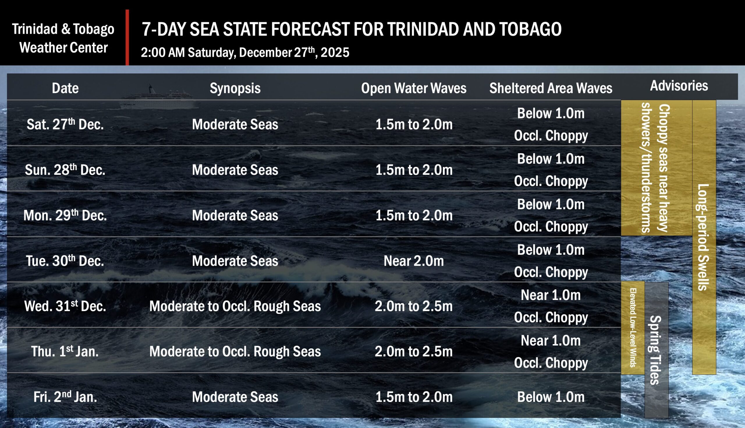
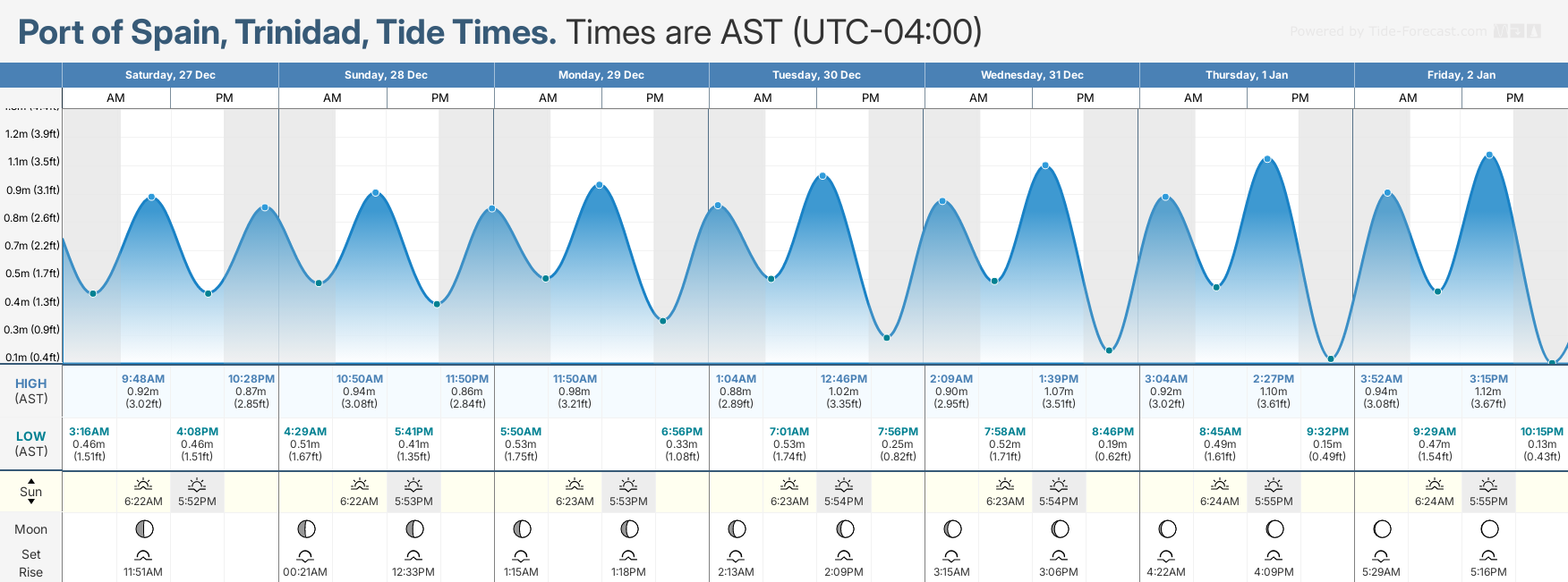
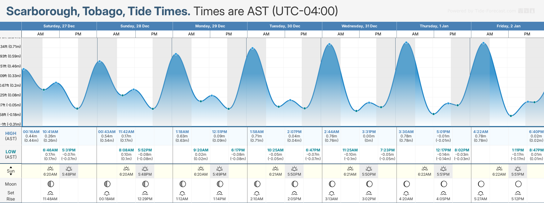
— What: Long-period swells up to 13 seconds are forecast to produce occasional, large, breaking waves through January 1st. In addition, spring tides from December 31st will enhance wave heights during high tides. Lastly, increased low-level winds, particularly in heavy showers/thunderstorms, are likely to lead to locally choppy/rough seas.
— Where: Swells are expected primarily impact Tobago’s north and northeastern coastlines, Trinidad’s north and northeastern coastlines, and to a lesser extent, north-facing coastlines of the Gulf of Paria. Locally choppy/locally rough seas are likely across the entire marine area in heavy showers and thunderstorms.
— When: Peak long-period swells up to 12 seconds are forecast through January 1st. Spring tides begin on December 31st. Elevated low-level winds are possible in heavy showers and thunderstorms between December 27th and December 30th, and again (not related to rainfall) from December 31st through January 1st.
— Impacts: Agitated seas with exacerbated conditions at high tides, larger-than-normal breakers with large, battering waves in the surf zone; possible disruption of near-shore activities, including fishing, swimming, and boat moorings; coastal flooding with intrusion of salt water, and displacement of sand, further than the average reach point particularly from December 31st, and elevated risk of rip currents, particularly along northern and eastern beaches.
— What Should You Do: All marine interests are advised to exercise caution. Inexperienced mariners should avoid navigating in hazardous conditions, especially those operating smaller vessels. Inexperienced swimmers should use beaches with on-duty lifeguards. Secure coastal property and objects on the beachfront that the wave action or winds may sweep away.
Latest Alerts

Localized Flood Alert Discontinued For Trinidad
Trinidad and Tobago is NOT under any tropical storm or hurricane threat, watch, or warning at this time.
Seas Forecast For Trinidad and Tobago
What should you do
All marine interests should practice common-sense safety. Small craft operators should seek safe harbor during heavy showers and thunderstorms. Inexperienced mariners, especially those operating smaller vessels, should avoid navigating in hazardous conditions. Inexperienced swimmers, if intending to go into the water, should use beaches with lifeguards on duty.
Secure coastal property and objects on the beachfront that the wave action or winds may sweep away, particularly on December 31st and January 1st, when elevated winds are forecast due to a strong pressure gradient across the area.
Elevated winds in downdrafts from heavy showers and thunderstorms will lead to choppy seas in the Gulf of Paria and larger-than-usual waves. Mariners should generally exercise caution during heavy showers or thunderstorms, as seas may become locally rough or choppy in their vicinity, particularly due to gusty winds.
Rip currents always pose a hazard on the nation’s beaches. If caught in a rip current, swim perpendicular to the current, parallel to the shore.
With spring tides from December 31st, mariners, especially small craft operators, should ensure their vessels are securely anchored or docked, as choppy or breaking wave conditions may drag the vessel onto the ocean floor or reefs in shallow waters, or even break the anchorage or mooring.


