Over the next seven days, T&T is forecast to be largely shielded by the Intertropical Convergence Zone and successive tropical waves from higher concentration Saharan Dust, lingering across the remainder of the Lesser Antilles, mainly northeast of the region.
What you need to know
— Saharan Dust Surges: A mild to moderate level of Saharan Dust is forecast to affect T&T and the Lesser Antilles from overnight Friday through Sunday morning, with another mild surge of dust affecting both islands, as well as the Lesser Antilles, from Tuesday, October 21st, 2025.
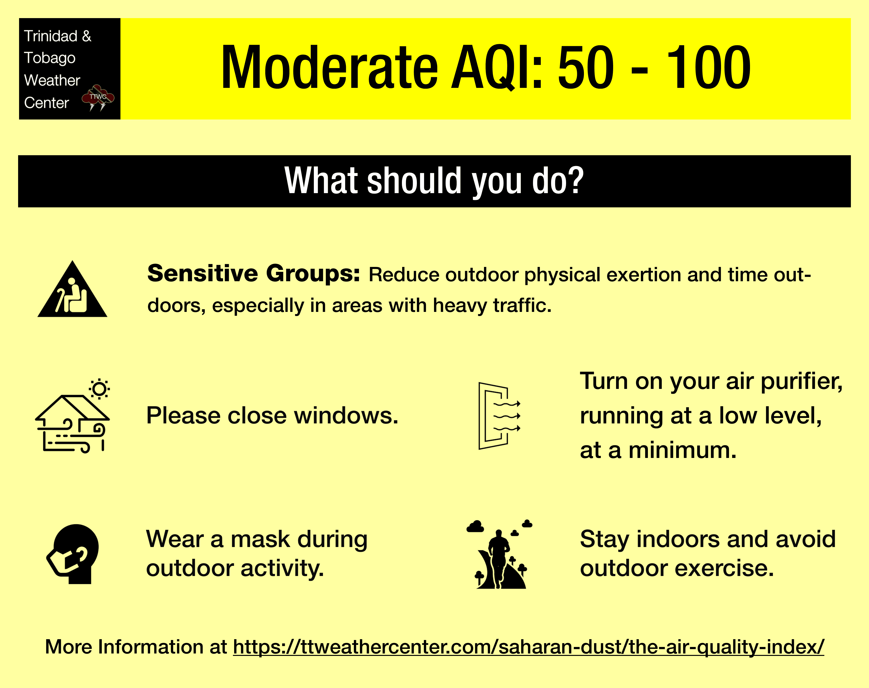
— What Should You Do: Unusually sensitive groups are advised to take necessary precautions, on Saturday through Sunday morning, and Tuesday through Thursday next week, while the general public remains mostly unaffected over the next seven to 10 days.
Current AQI Levels Across T&T
As of 6:00 PM Friday, October 17th, 2025, official air quality monitoring stations from the Environmental Management Agency (EMA), except Beetham, Port of Spain, are not reporting PM2.5 or PM10 data.
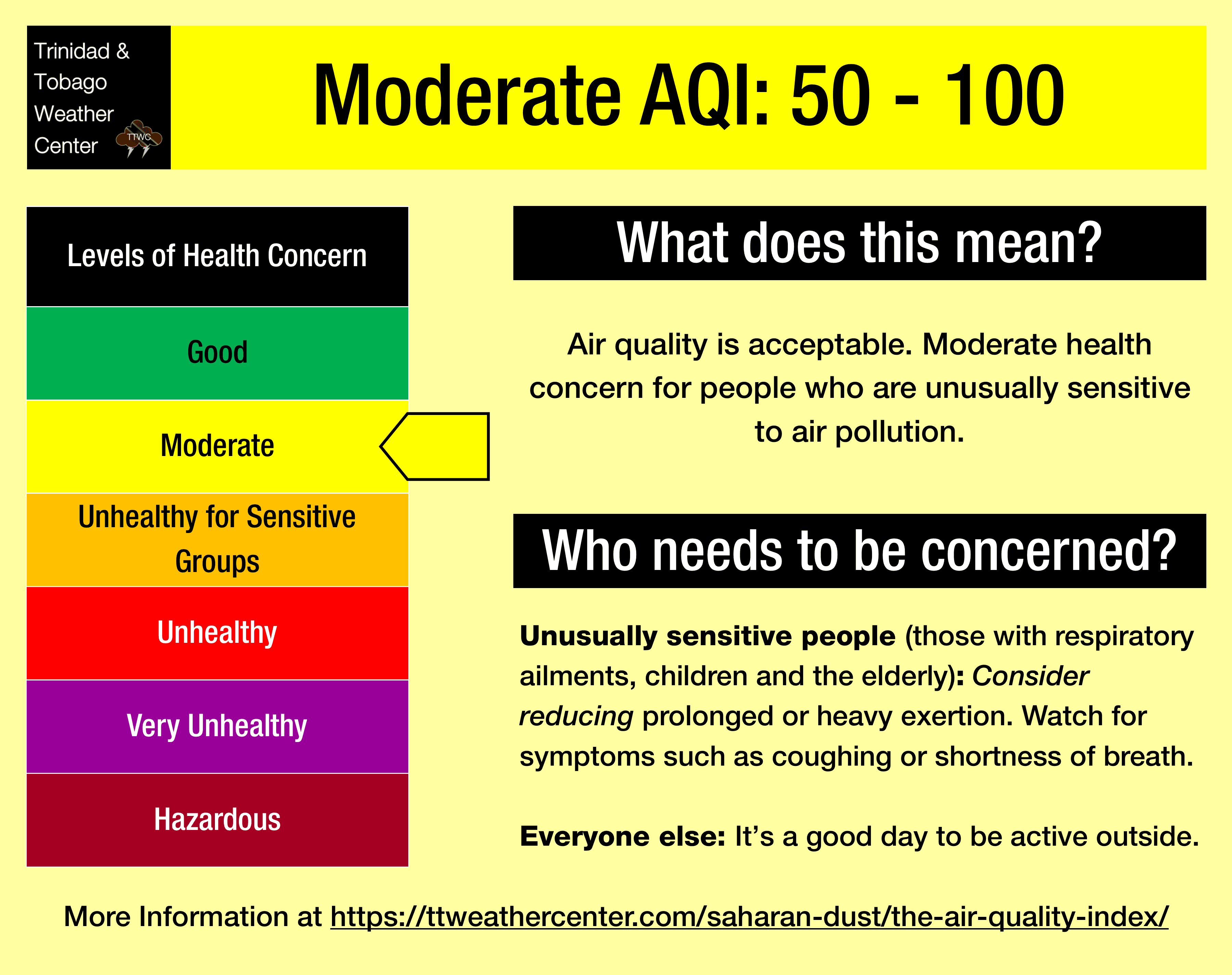
Unofficial air quality monitoring stations at Longdenville and Woodbrook report good air quality levels, while an official station at Beetham, reports air quality levels that are moderate.
These measurements are based on PM2.5 (particulates smaller than 2.5 micrometers in size, typically associated with increases in Saharan Dust, vehicle exhaust, and smoke) and PM10 particulates.
Outside of rainfall, visibility, used as a proxy for Saharan Dust concentrations, at the A.N.R. Robinson International Airport at Crown Point, Tobago, and Piarco, remains at 10 kilometers over the last 24 hours.
Saharan Dust Forecast For T&T
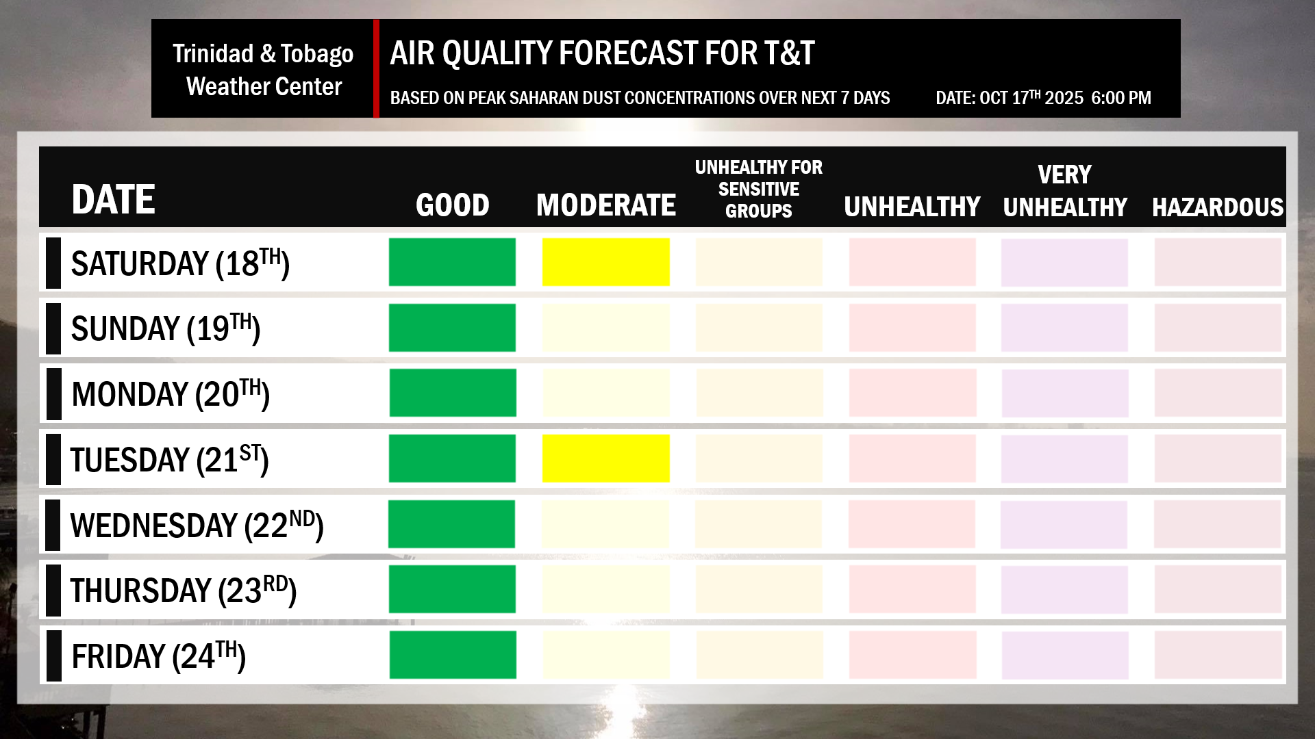
October 17th through early October 19th: Mild to moderate (Tobago) concentrations of Saharan Dust with air quality levels generally at good to moderate levels. Higher dust concentrations are forecast across northern Trinidad and Tobago. Horizontal visibility is generally unaffected by dust.
October 19th through 20th: Little to no Saharan Dust forecast with air quality at good levels. Horizontal visibility is generally unaffected by dust.
October 21st through 23rd: Mild to moderate concentrations of Saharan Dust with air quality levels generally at good to occasionally moderate levels. Higher dust concentrations are forecast across northern Trinidad and Tobago. Horizontal visibility is generally unaffected by dust.
October 23rd through October 29th: Little to no Saharan Dust forecast with air quality at good levels. Horizontal visibility is generally unaffected by dust.
What does this mean for you?
Generally, over the next 10 days, air quality levels are forecast to be mainly moderate, with periods of good air quality during the passage of the ITCZ or tropical waves.
We’re now in a period where the Intertropical Convergence Zone, tropical waves, and occasional tropical cyclones may shield Trinidad and Tobago from the Saharan Dust events. While tropical waves are notable in moving dust across the Atlantic and the Eastern Caribbean, these periodic tropical waves also improve air quality.
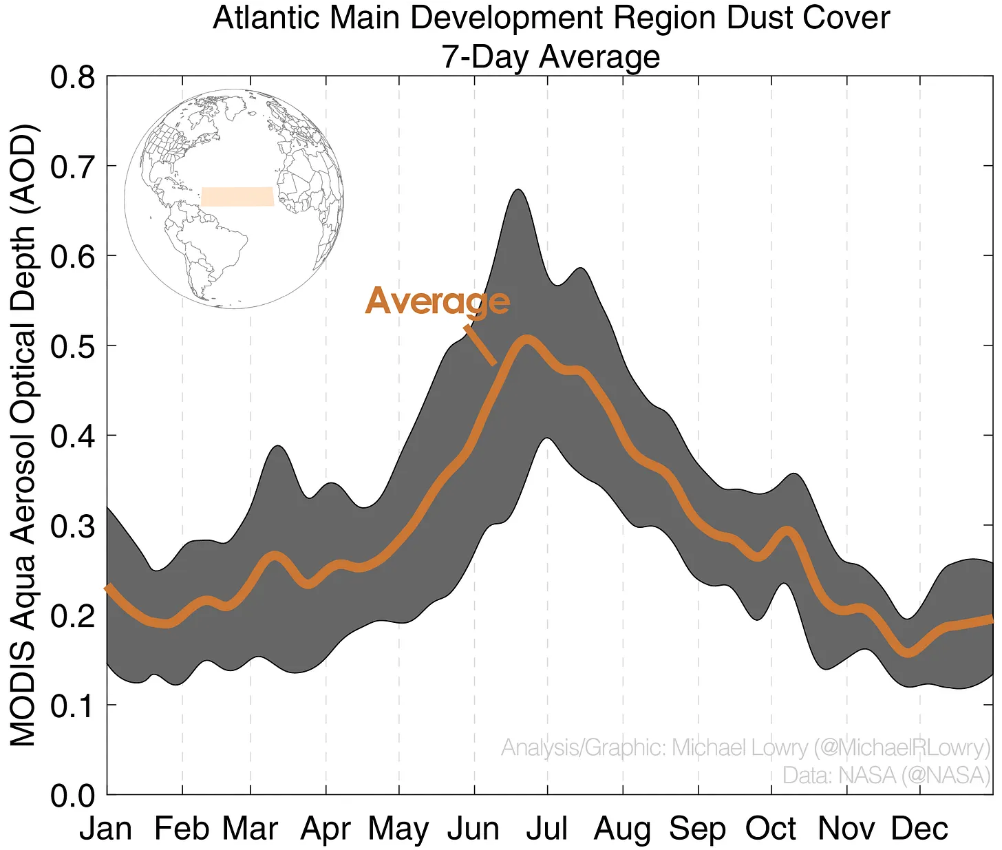
Peak dust concentrations climatologically occur during June across the Main Development Region of the Atlantic, just east of Trinidad and Tobago.
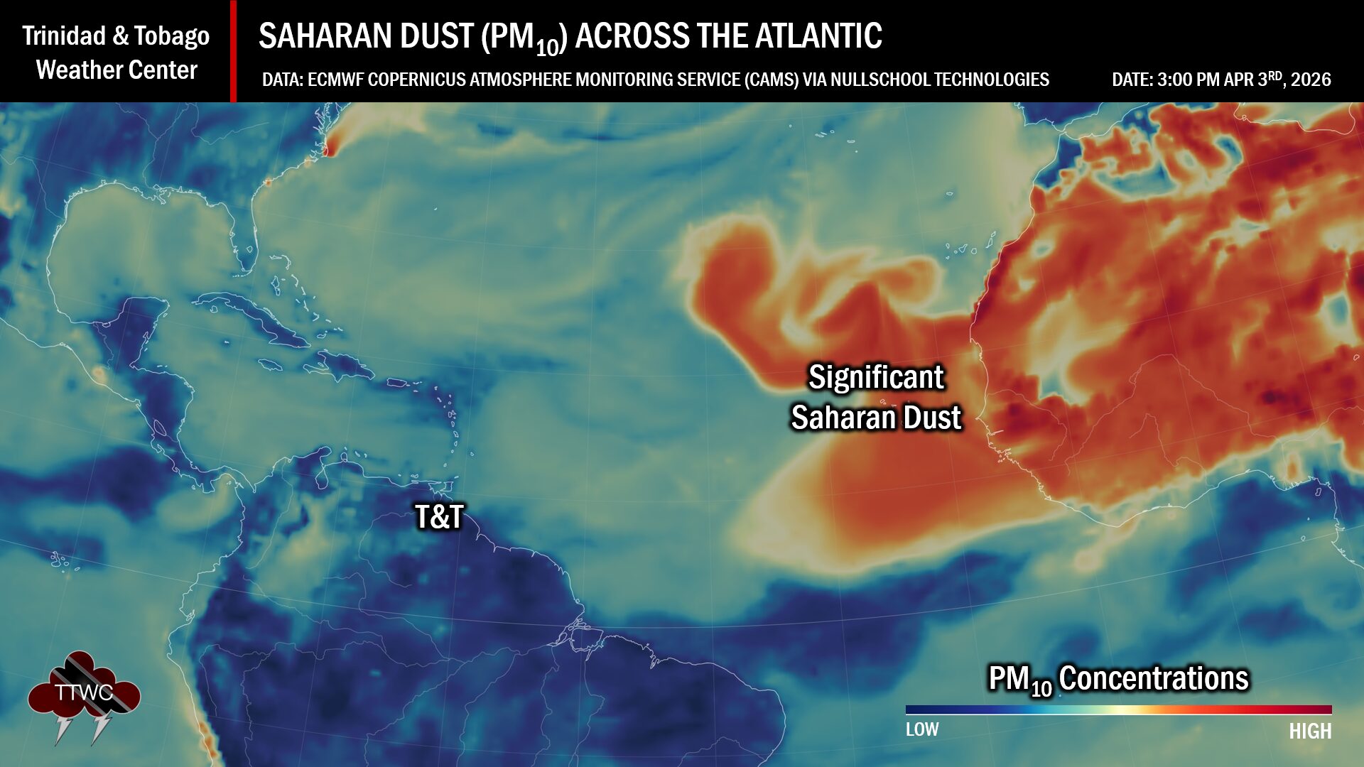
The concentration of the dust that follows the wave depends on its strength as it moves off the West African Coast. This is because of stronger thunderstorms across Central Africa. As strong winds move downward and outward from these thunderstorms, they kick up dust as they move across parts of the Saharan Desert and transport it into the upper atmosphere. This “plume” of dust follows the axis of the wave as it progresses westward into the Atlantic.
Dust that enters the upper levels of the atmosphere can then be transported across the Atlantic Ocean. The plumes of dust eventually affect the Eastern Caribbean.
Larger, more concentrated plumes of Saharan dust begin in April and continue through November.