


An active tropical wave (Tropical Wave 19) is nearing Trinidad and Tobago, bringing the Intertropical Convergence Zone across the country. Intervals of showers and isolated thunderstorms through Friday. However, most of the intense activity is forecast to remain to the south and east of the country. Showers and thunderstorms are also set to affect T&T through the weekend, as the ITCZ lingers, with Tropical Wave 20 also on the approach.
What you need to know
— Rainfall: Through the next 24 hours, mainly after midnight tonight (Thursday into Friday), periodic rain, moderate to heavy showers, and isolated thunderstorms are forecast. Peak intense activity, including isolated heavy to violent showers and intense thunderstorms, are forecast to favor the early morning through early afternoon hours. Rainfall totals between 15-35 millimeters are forecast across the country, with higher rainfall totals up to and exceeding 50 millimeters across localized areas of western coastal, southern, and eastern Trinidad and across Tobago.
— Hazards: Chances for street/flash flooding are medium to high through Friday afternoon. Chances for riverine flooding remain low at this time. Gusty winds, in excess of 55 KM/H accompanying heavy showers or thunderstorms are likely. Lightning will accompany thunderstorms.
— Alerts/Watches/Warnings: An Adverse Weather Alert (Yellow Level) is in effect for Trinidad and Tobago from 5:00 AM Friday, July 15th, 2022, through 6:00 PM Friday, July 15th, 2022 from the Trinidad and Tobago Meteorological Service. There are no tropical storm or hurricane watches or warnings in effect for T&T at this time.
The Adverse Weather Alert
The Trinidad and Tobago Meteorological Service has issued an Adverse Weather Alert (Yellow Level) on Thursday afternoon at 2:53 PM. The alert goes into effect at 5:00 AM Friday, July 15th, 2022, through 6:00 PM Friday, July 15th, 2022.
Trinidad and Tobago is not under any tropical storm watch or warning at this time.
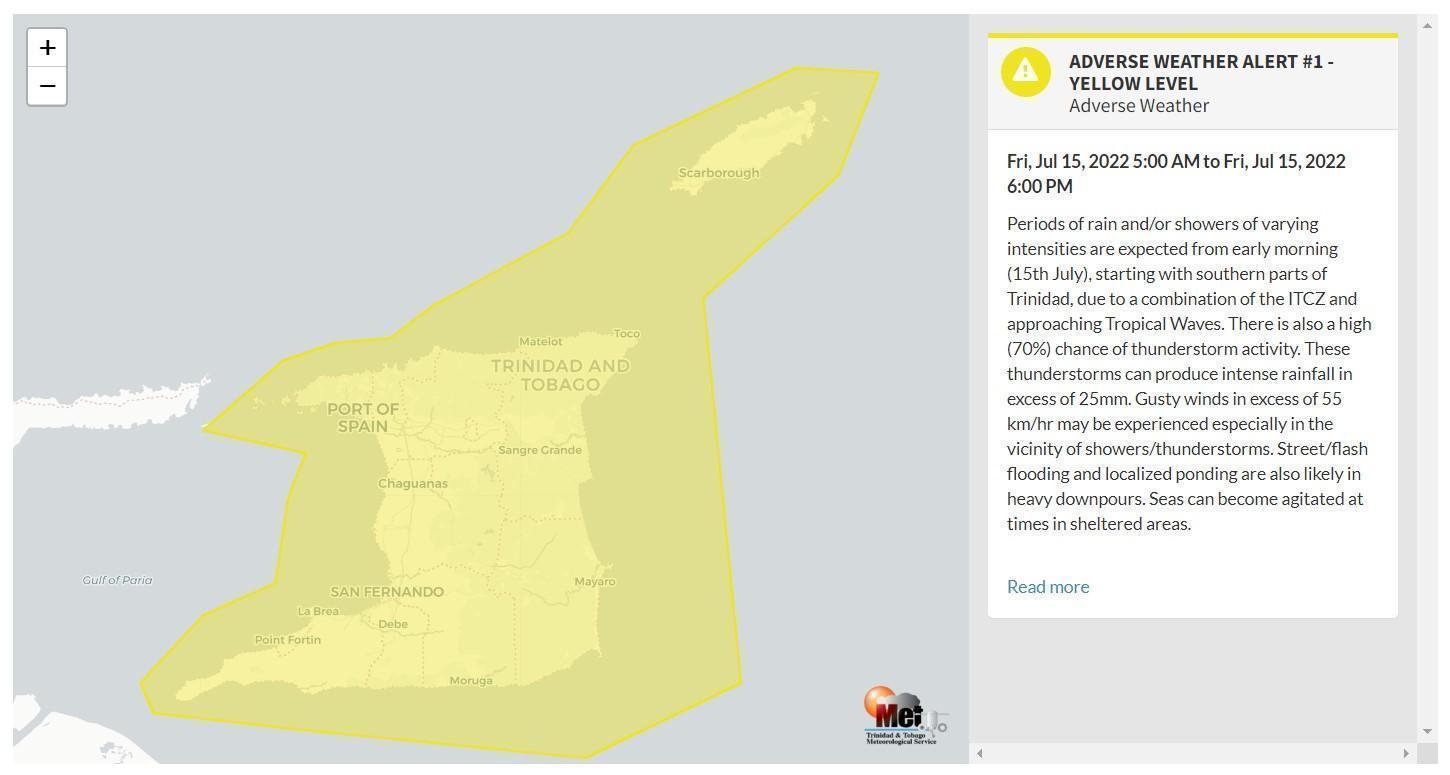
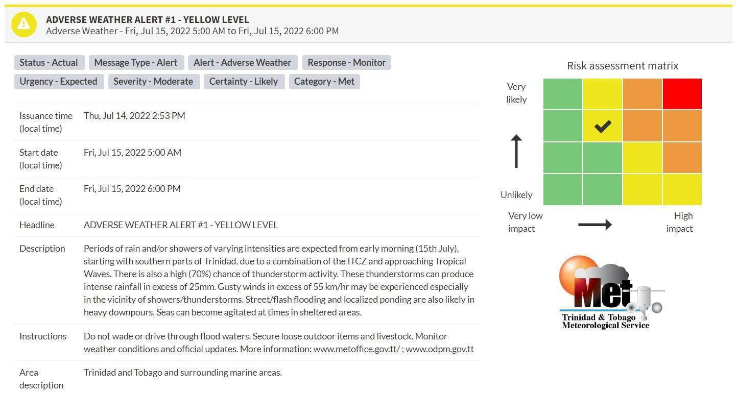
“Periods of rain and/or showers of varying intensities are expected from early morning (15th July), starting with southern parts of Trinidad, due to a combination of the ITCZ and approaching Tropical Waves. There is also a high (70%) chance of thunderstorm activity. These thunderstorms can produce intense rainfall in excess of 25mm. Gusty winds in excess of 55 km/hr may be experienced, especially in the vicinity of showers/thunderstorms. Street/flash flooding and localized ponding are also likely in heavy downpours. Seas can become agitated at times in sheltered areas.” according to the Trinidad and Tobago Meteorological Service. This “alert” status takes into account the possibility of the event occurring. This adverse weather event is likely.

The color of the alert indicates the severity of the event and the probability of the event occurring. Currently, the alert level is Yellow. This means that the hazards are likely, but the severity of impacts is moderate for this particular alert. You should be aware of the hazards in your area associated mainly with gusty winds in excess of 55 KM/H, street, and flash flooding as well as frequent lightning.
For a moderate Adverse Weather Alert, there is the potential for possible injuries, where behavioral changes are required to ensure safety. There may be minor damage to property, with income-earning temporarily disrupted and a couple of communities affected.
The Met Office is advising the public to be alert for cloud-to-ground lightning activity and not venture into floodwaters, secure loose objects outdoors as well as monitor weather conditions and updates from official sources.
Small craft operators should be on the alert for above-normal or choppy sea conditions in strong winds.


