

Trinidad and Tobago was shaken by two moderate earthquakes within 70 minutes early on Monday morning, one north of Tobago and the other northwest of Trinidad. Both were widely reported felt across both islands. There are no reports of damage or injury.
The first quake, at magnitude 5.1, struck at 5:45 AM approximately 23.7 kilometers northeast of Scarborough, Tobago, at a depth of 59.4 kilometers. It was located 6.5 kilometers northwest of Charlotteville and 13 kilometers east-northeast of Castara. This quake was widely reported felt across Tobago and much of Trinidad.
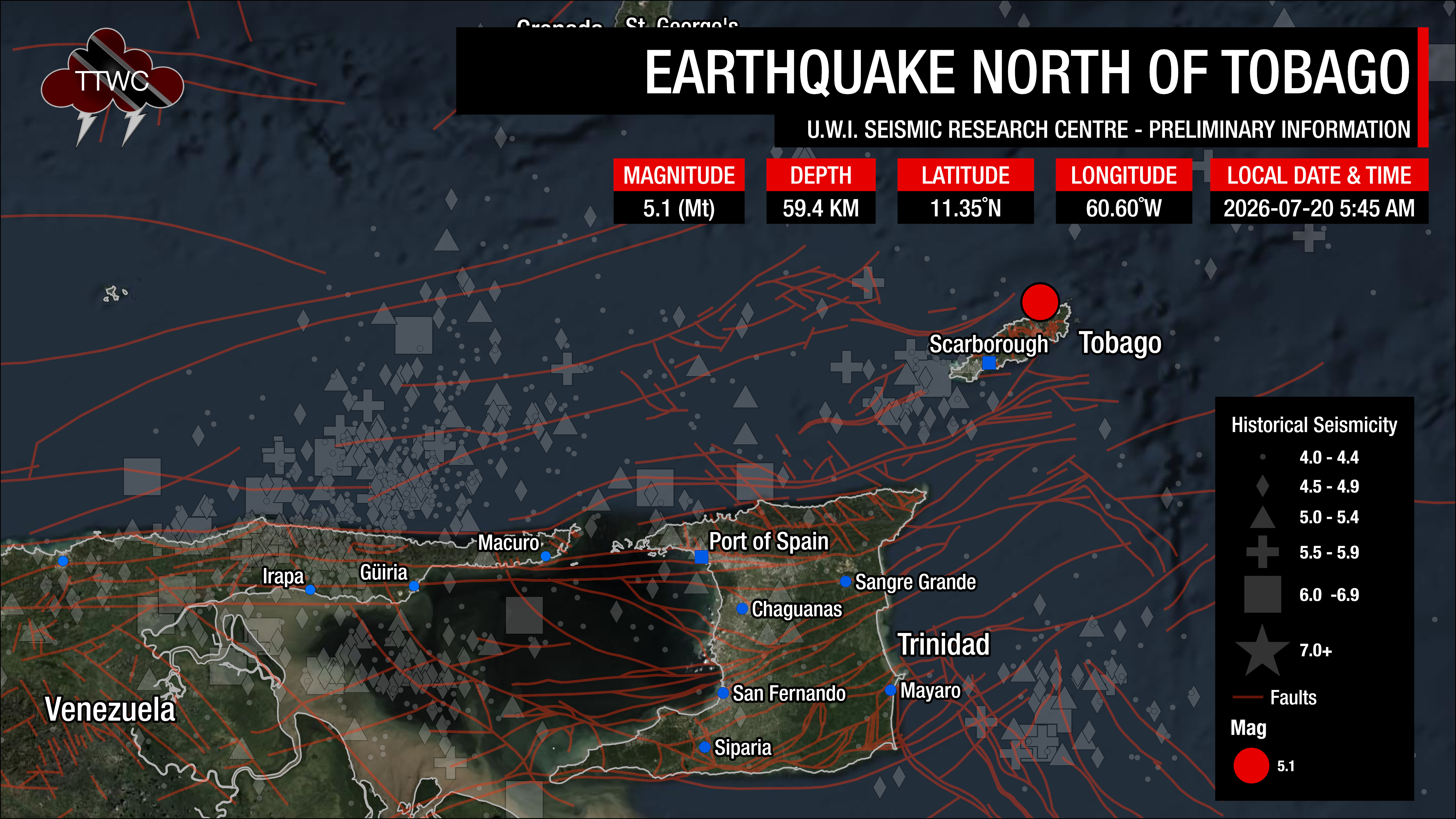
This is the strongest earthquake recorded within 20 kilometers of that spot in the instrumental record. Fewer than 100 earthquakes have been recorded in that same 20 kilometer radius since instrumental monitoring began, and most of them occur at depths near 50 kilometers. The closest comparable event was a magnitude 5.2 on September 20, 1982, about 30 kilometers away.
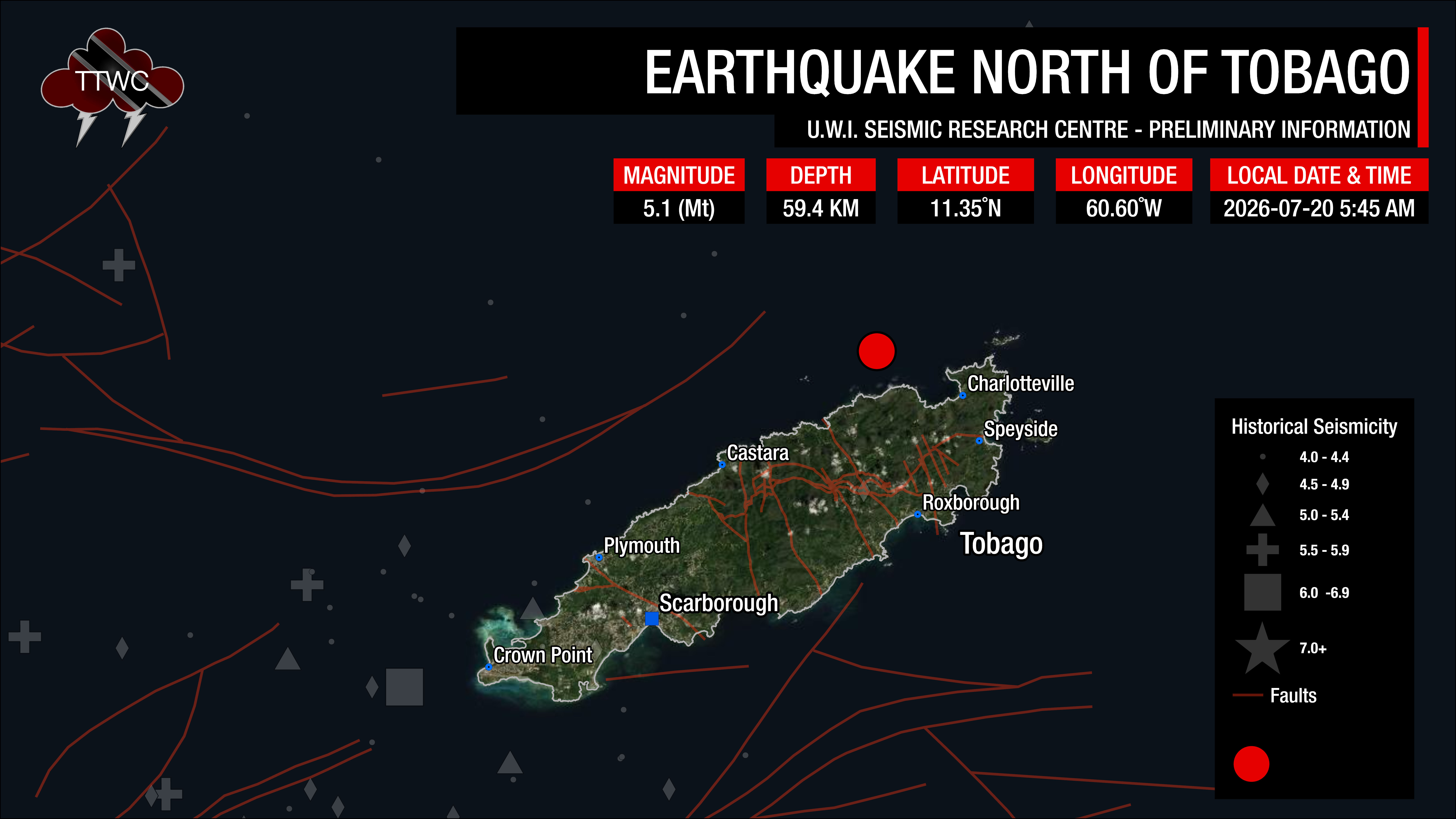
The second quake, at magnitude 5.0, struck at 6:55 AM, 70 minutes after the first, approximately 67.5 kilometers northwest of Port of Spain, Trinidad, at a depth of 80.1 kilometers. It was located 36.2 kilometers north-northwest of Macuro and 51.1 kilometers northeast of Guiria, Venezuela. This quake was also widely reported felt across Trinidad.
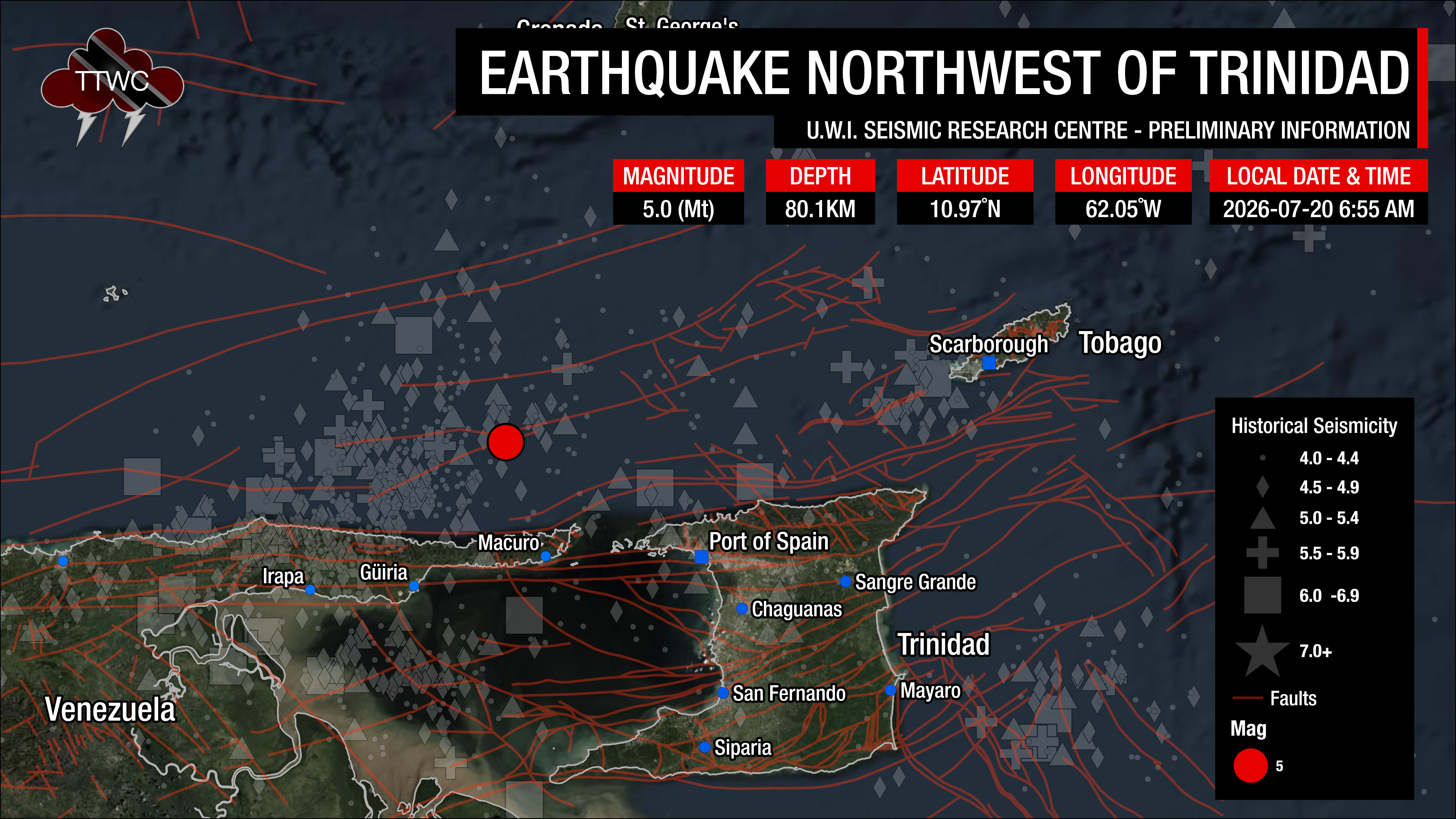
Unlike the Tobago earthquake, this one was entirely routine for where it happened. More than 1,400 earthquakes have been recorded within 20 kilometers of that location, including about 7 at magnitude 5.0 or above. The strongest was a magnitude 5.5 on May 11, 2025.
You can submit felt reports to the University of the West Indies Seismic Research Centre.
The UWI SRC, the authority for seismic and volcanological information in the English-speaking Eastern Caribbean, has reviewed both earthquakes. Upon further review, parameters like each quake’s depth, magnitude, and location may change.
Why the two quakes felt different
Trinidad and Tobago has exactly one seismometer whose records are publicly accessible in a form that can be independently analyzed: a Raspberry Shake citizen station in north-central Trinidad. It recorded both earthquakes. Because the same instrument in the same place captured both, the two records can be compared directly, with no need to correct for different equipment or different ground conditions.
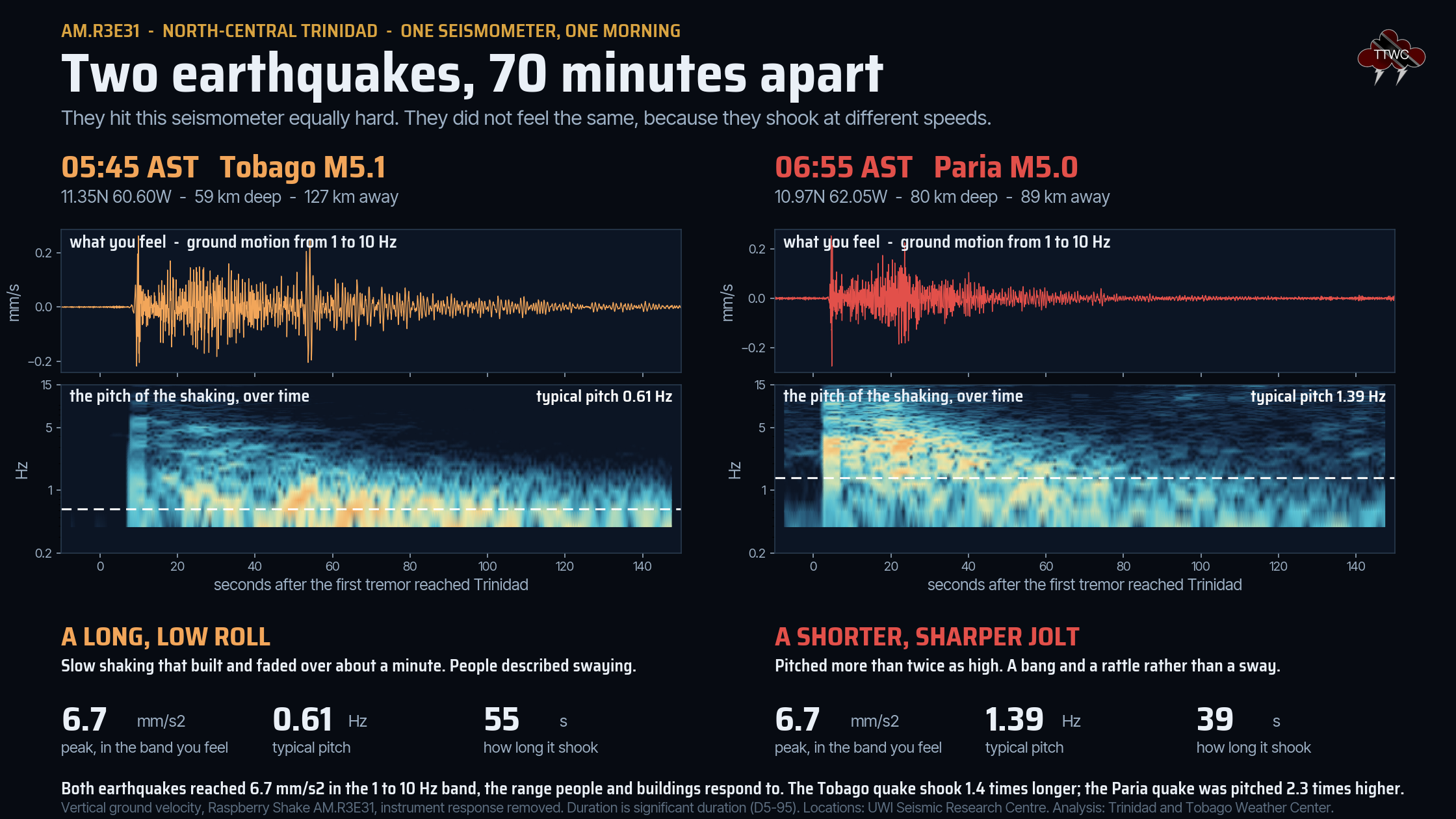
Both earthquakes hit that seismometer with almost exactly the same force in the frequency range that people and buildings actually respond to, between 1 and 10 hertz. Both peaked at 6.7 millimeters per second squared. That is why both were widely felt, despite the Tobago quake being more than 30 kilometers further away.
What differed was the character of the shaking. The Tobago earthquake arrived at a typical pitch of 0.61 hertz, roughly one back-and-forth movement every 1.6 seconds, and its significant shaking lasted about 55 seconds. The Paria earthquake arrived at 1.39 hertz, more than twice as fast, and lasted about 39 seconds.
In practical terms, the first earthquake was a long, low roll and the second was a shorter, sharper jolt. That is a real difference in the ground motion, not a difference in how people happened to describe it. Slower shaking is felt more readily by people in taller buildings, while faster shaking tends to rattle objects and is more noticeable at ground level.
There is no tsunami threat.
There are four conditions necessary for an earthquake to cause a tsunami:
- The earthquake must occur beneath the ocean or cause material to slide within or into the ocean.
- The earthquake must be strong, with at least a magnitude of 6.5.
- The earthquake must rupture the Earth’s surface and occur at a shallow depth, less than 70 kilometers below the surface.
- The earthquake must cause vertical movement of the seafloor (up to several meters).
Both earthquakes occurred beneath the sea, and the Tobago earthquake was shallower than 70 kilometers. However, neither came close to the magnitude threshold, and neither produced vertical movement of the seafloor. No tsunami was generated and none was expected.
Note that different seismic monitoring agencies use different methods, or multiple methods, to process quake parameters worldwide. Each method has its limitations and will likely yield different results within the data’s uncertainty range. This is generally accepted within the scientific community.
The United States Geological Survey (USGS) recorded the Tobago earthquake at magnitude 5.2 and a depth of 84 kilometers, placing it about 22 kilometers from the UWI SRC location. It recorded the second earthquake at magnitude 4.8 and a depth of 66 kilometers, about 37 kilometers from the UWI SRC location. The UWI SRC operates the regional network and its manually reviewed solutions are generally the more reliable of the two for earthquakes this close to Trinidad and Tobago.
Read More

Earthquake Magnitude & Intensity

Can earthquakes be predicted or forecasted?
Two earthquakes, two very different seismic zones
Trinidad and Tobago and its surrounding waters can be split into eight distinct seismic zones. The two earthquakes on Monday morning came from opposite ends of that map, and that is the clearest way to understand why one was ordinary and the other was not.
The magnitude 5.0 northwest of Trinidad occurred in Zone 1, north of the Paria Peninsula. This is the most seismically active area near Trinidad and the second-most active in the Eastern Caribbean. In this zone the South American plate descends rapidly into the Earth’s mantle, with detached oceanic lithosphere sitting at depths between 50 and 300 kilometers (Russo et al. 1993). At shallower levels, the North Coast Fault Zone and the El Pilar Fault, part of the Bocono, San Sebastian and El Pilar fault system, accommodate the stress built up as the Caribbean plate slides past the South American plate.
At a depth of 80.1 kilometers, Monday’s earthquake was well inside the descending slab rather than on one of the shallower faults. The UWI SRC records approximately 65 earthquakes of magnitude 2.1 and above in Zone 1 every year. Historically this zone has produced the largest earthquakes felt in Trinidad. The 1766 magnitude 7.9 event, estimated to have been located in this area, destroyed the then-capital of San Jose. The 1888 magnitude 7.5 event was damaging from Trinidad to St. Vincent. The largest of the instrumental period, on September 20, 1968, was a magnitude 7.0 that caused significant damage in Venezuela and in Port of Spain.
The magnitude 5.1 north of Tobago is the more unusual of the two. It did not occur inside any of the eight defined seismic zones. Zone 7 covers the waters south and west of Tobago, and Zone 8 covers the area east of Trinidad and south of Tobago. Neither extends around to the island’s northeastern end, which is where Monday’s earthquake struck, 6.5 kilometers northwest of Charlotteville.
The zones exist because seismicity clusters, and this earthquake happened outside the clusters. Fewer than 100 earthquakes have ever been recorded within 20 kilometers of it, and none of them was this large. For comparison, the magnitude 5.2 of September 20, 1982, which began months of activity and effectively put Zone 7 on the map, was located west of Tobago at 11.221 degrees north and 60.847 degrees west, about 30 kilometers from Monday’s epicenter. The damaging April 1997 sequence, the largest recorded in Zone 7, was also west of the island.
Monday’s earthquake was therefore not an aftershock or a continuation of any known sequence. It happened in a quiet corner, which is a useful reminder that the zones describe where earthquakes are most likely, not where they are confined.
Can weather (and hot air temperatures) cause earthquakes?
The weather does not affect or cause seismic events in Trinidad and Tobago. When hot weather occurs, one of the most common comments is that it is “earthquake weather.”
It’s a fairly common misconception whose origins date back to the 4th century B.C. Aristotle proposed that earthquakes were caused by winds trapped in subterranean caves. Small tremors were thought to have been caused by air pushing on the cavern roofs, and large ones by the air breaking the surface.
This theory leads to the belief that, because a large amount of air is trapped underground, the weather would be hot and calm before an earthquake. A later theory stated that earthquakes occurred in calm, cloudy conditions and were usually preceded by strong winds, fireballs, and meteors.
There is no such thing as “earthquake weather.” Statistically, there is approximately an equal distribution of earthquakes in cold weather, hot weather, rainy weather, etc.
Very large low-pressure changes associated with major storm systems (typhoons, hurricanes, etc.) are known to trigger episodes of fault slip (slow earthquakes) in the Earth’s crust. They may also trigger some damaging earthquakes. However, the numbers are small and not statistically significant.
Water can remove sediment, infiltrate the ground, and increase or decrease overburden pressures. This change in ground pressure can trigger minor seismic activity. Excessive rainfall, not hot weather, can also contribute to minor seismic activity.
Earthquake weather does not exist, and hot temperatures do not cause earthquakes.
Source: USGS
Has there been an increase in seismic activity?
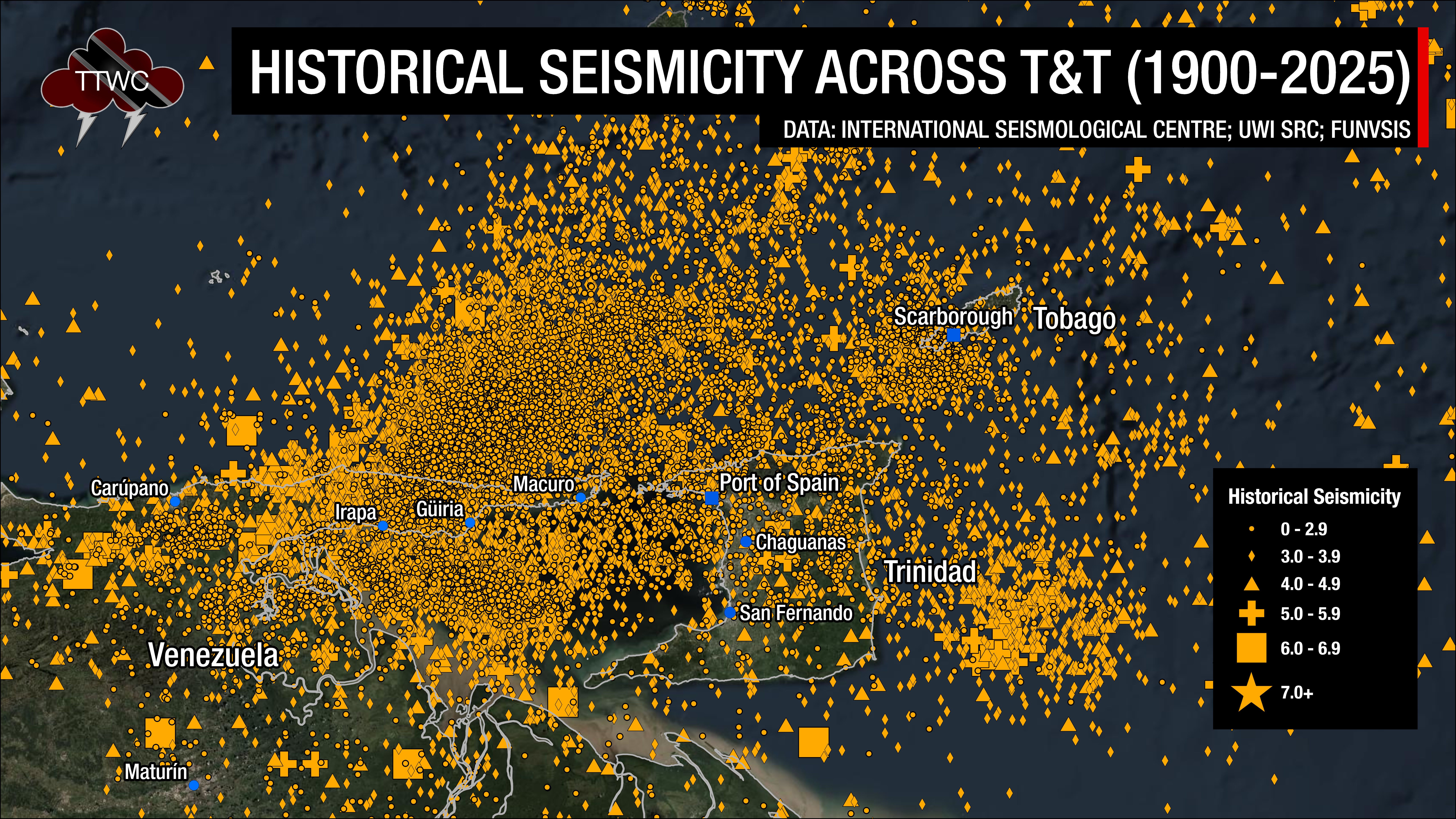
Trinidad and Tobago and the surrounding region are very seismically active. Across the Eastern Caribbean, over 2,200 earthquakes are recorded annually. Since 1990, and as of 2025, the UWI SRC has recorded an annual average of 260 earthquakes in the Trinidad and Tobago region (bounded by 9.5°-11.5°N & 59.5°W-63.5°W) with magnitudes greater than 2.0.
Most earthquakes occur northwest of Trinidad, in an area north of the Paria Peninsula, which has the second-highest seismicity in the Eastern Caribbean, and within the Gulf of Paria. According to the UWI SRC, approximately 100 quakes occur north of the Paria Peninsula annually, and 60 quakes occur within the Gulf of Paria.
With increased instrumentation (seismometers) and greater reporting on social media, it may appear that earthquake activity in the region has risen dramatically, but this is unlikely to be the case. However, the UWI SRC has repeatedly noted that, since the 2000s, seismic activity in the region has increased overall.
On average, the Eastern Caribbean has experienced a pattern of major (M7.0-M7.9) earthquakes every 20 to 30 years. That pattern has stayed true. The last major (M7.0 to M7.9) quake occurred north of Martinique in 2007.
Historical patterns indicate that great quakes (M8.0+) have occurred every century in the region. The probability of another event at that level is high since the last M8.0 or greater earthquake occurred in 1843. While it is impossible to definitively say when the next great quake will occur in the region, the last one occurred more than 170 years ago.
It is important to note that seismic activity cannot be predicted. Based on current research and technology, the precise time, date, magnitude, depth, etc., cannot be known in advance.
Now is the time to create or review your earthquake preparedness plan and know what to do during, before, and after an earthquake.
Read More
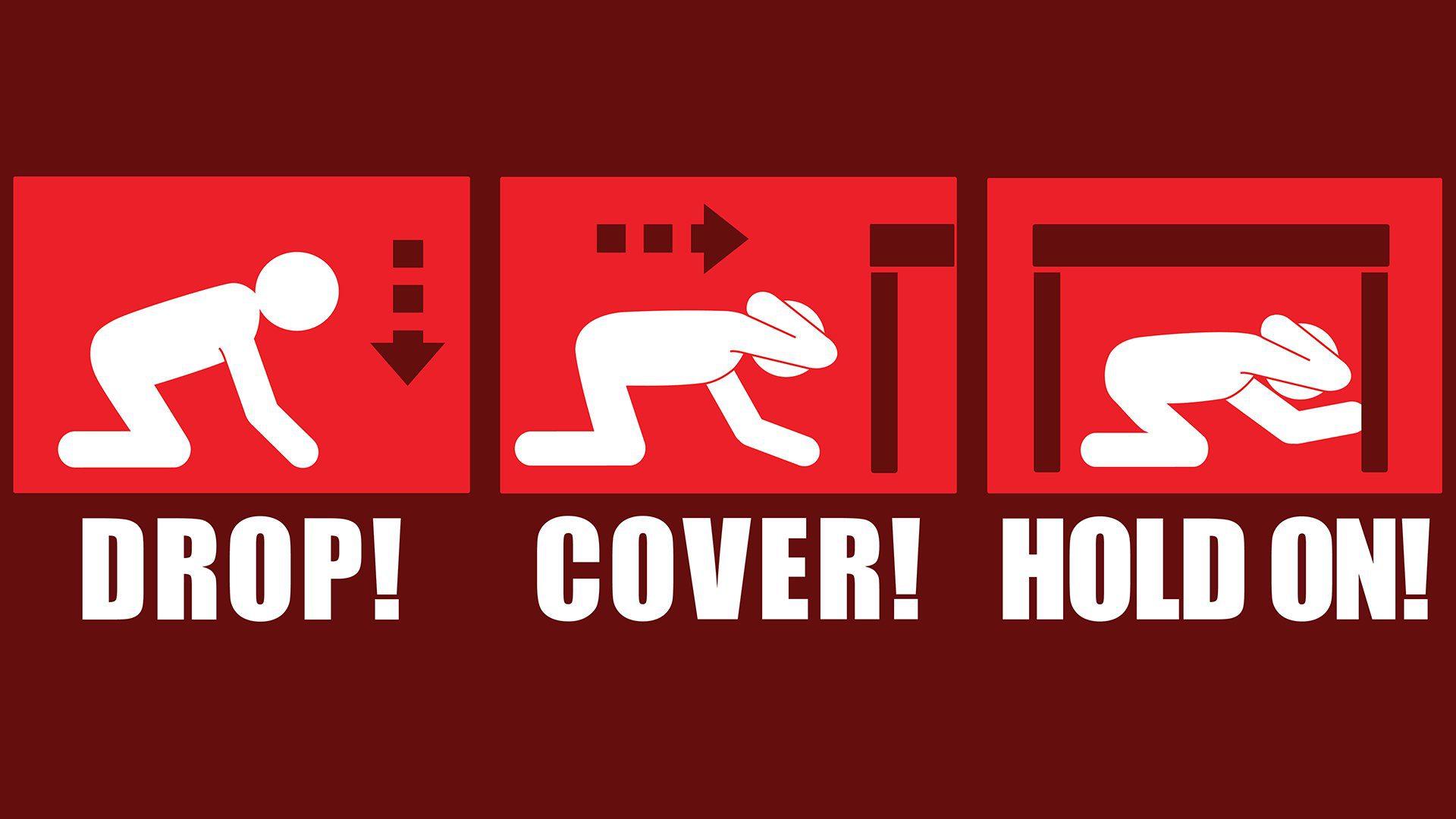
In our region, earthquakes can strike at any time and any place, so it is important to know how to keep yourself safe when one strikes.