


Parts of northwestern and southern Trinidad experienced heavy rainfall on Thursday afternoon, leaving multiple roadways underwater just in time for the evening commute.
While flood waters quickly ran off in Port of Spain and environs, several roadways across parts of Penal and Barrackpore remained inundated late into Thursday night, hindering motorists.
What happened?
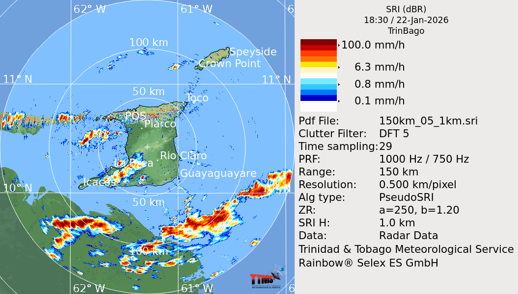
A broad low-to-mid-level trough, now located in the far eastern Caribbean Sea, has brought increased moisture and convergence across Trinidad and Tobago on Thursday. Convergence (air masses colliding and rising in the atmosphere) and low-level confluence (air masses slowing and piling up like cars in a traffic jam) led to Thursday’s showers, which slowly moved from the south and east to the north.

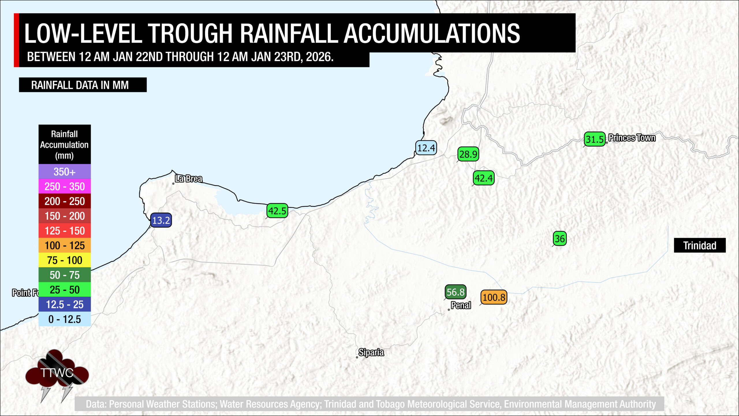
Across the western half of Trinidad, locally intense rainfall developed, with rates exceeding 50 to 100 millimeters per hour, particularly between 2:30 PM and 6:00 PM on Thursday.
Mainly across parts of Penal and Barrackpore, and generally across northwestern Trinidad, rainfall totals ranged from 25 to 100 millimeters, with locally higher amounts recorded.

Affected areas
Flooding was concentrated in two areas: southern Trinidad, between Barrackpore and San Francique, and northwestern Trinidad, from Port of Spain to Cocorite. TTWC has collated over 21 reports of flooding, with one report of a landslide.
Flooding on Thursday afternoon along the eastbound lanes of the Western Main Road, Cocorite, following heavy rainfall. https://t.co/hBAcmuthWu pic.twitter.com/1kQf8fJIrJ
— TTWeatherCenter (@TTWeatherCenter) January 23, 2026
Parts of Tragarete Road, Philips Street, Victoria Avenue, Queen’s Park West, Cipriani Boulevard, as well as streets across Lower Port of Spain experienced short-lived street flooding from 3:45 PM. Flooding was also reported along Ariapita Avenue and Wrightson Road in Woodbrook. Traffic was brought to a standstill along the Western Main Road (eastbound) at Cocorite as flood waters affected most lanes, as well as the underpass near St. James. Along the Lady Young Road, a minor landslide was also reported. By 6:00 PM, nearly all flooding across Port of Spain subsided.
Flooding on Thursday afternoon at Lowkie Trace, Penal following heavy rainfall. https://t.co/hBAcmuthWu pic.twitter.com/HEIZ40sLqB
— TTWeatherCenter (@TTWeatherCenter) January 23, 2026
Meanwhile, flooding began at Lowkie Trace, Charlo Village, as well as Lachoos Road, Penal, as early as 2:40 PM. As rainfall intensified in the afternoon, street and flash flooding were reported along S.S. Erin Road in Penal, near Bick’s Auto and South Savers, as well as in San Francique, where the roadway became temporarily impassable near Triple J’s Bar.

Flooding was also reported on the San Francique Road and Antilles Trace in San Francique; Clarke Road in Penal at multiple locations, including in the vicinity of the Penal Fire Station and Shiva Boys’ Hindu College; and at Katwaroo Trace and Teemul Trace in Penal
Late into the night, flood waters continued to move across Papourie Road and Cumuto Trace South in Barrackpore, gradually moving into tributaries of the South Oropouche River.
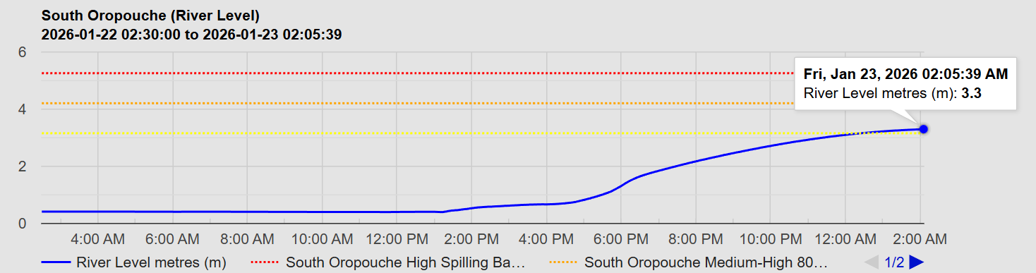
By early Friday morning, the South Oropouche River at Sanahie Trace was at 63% and approaching its crest according to streamflow data from the Water and Sewage Authority’s Water Resources Agency.
What’s next?
On Friday, as low-level confluence and elevated moisture remain present, additional showers, which may become heavy, are forecast to move across both Trinidad and Tobago. However, unlike Thursday, heavier rainfall is forecast to favor the eastern half of Trinidad, mainly from the early morning through the early afternoon. During the late morning through afternoon, there may be one or two heavy showers favoring the western and hilly areas of Trinidad.
Conditions are forecast to settle into the night, barring the odd shower favoring eastern areas of both islands. While markedly drier conditions are forecast on Saturday, lingering moisture may still lead to a locally heavy shower or two, favoring hilly and western areas of Trinidad during the afternoon.
Trinidad and Tobago has been officially in the Dry Season since January 8th, according to the Trinidad and Tobago Meteorological Service. However, January was forecast to be wetter than normal.


