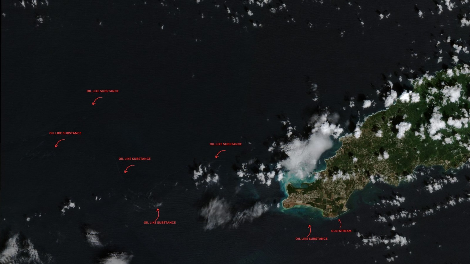
Latest satellite data indicates the oil-like substance originating from an overturned vessel near Cove, Tobago, has spread significantly west and northwest of Tobago on Sunday.
The Tobago Emergency Management Agency (TEMA) said on Sunday evening, “Unconfirmed possible oil, originating from an overturned vessel approximately 150 meters south-southeast of the southern coast of Cove, was observed in satellite imagery on February 12th, 2024, at 1437HRS.”
The data, taken from Sentinel-2, revealed a silver-like slick emanating from the wrecked vessel, accompanied by streaks of a thick, black-like substance.
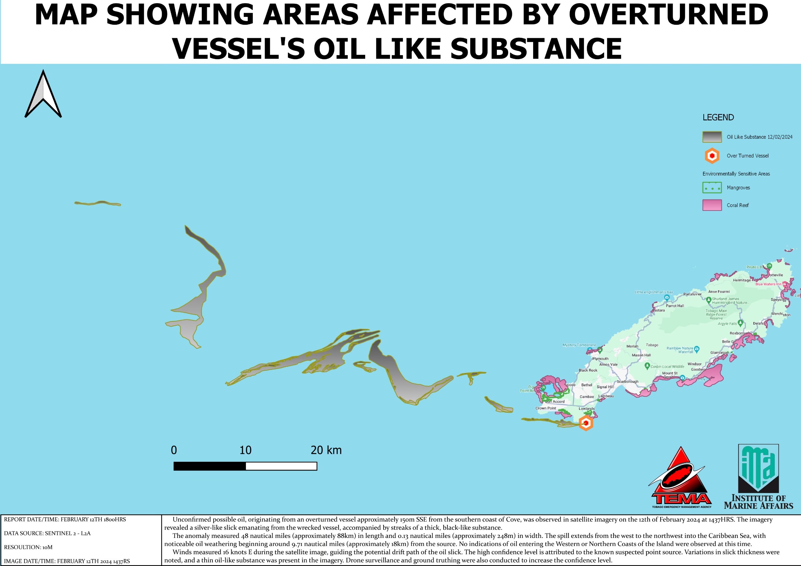
TEMA says the anomaly measured 48 nautical miles (approximately 88 kilometers) in length and 0.13 nautical miles (approximately 248 meters) in width. They added that the spill extends from the west to the northwest into the Caribbean Sea, with noticeable oil weathering beginning around 9.71 nautical miles (approximately 18 kilometers) from the source.
Samples have been sent to the Institute of Marine Affairs for fingerprinting. Once the samples are run, the type of substance can be identified. In the past, crude oil has been misidentified as bunker fuel or another type of hydrocarbon. To ensure accuracy in reporting, until the samples are confirmed to be crude oil (or otherwise), we will continue to use “oil-like substance” in our reporting. TEMA estimates the IMA report should come in sometime this upcoming week.
Since the westward movement of the oil-like substance began, Tobago’s coastlines have seen some relief from the thick, black material washing up on the island’s shores. TEMA indicated there are no indications of oil entering the western or northern coasts of Tobago at this time.
Winds measured 16 knots from the east during the satellite image, guiding the potential drift path of the oil slick. The high confidence level is attributed to the known suspected point source. Variations in slick thickness were noted, and a thin oil-like substance was present in the imagery. Drone surveillance and ground truthing were also conducted to increase the confidence level of TEMA.
IMA conducting ecological assessments
The Institute of Marine Affairs (IMA) has dispatched a team to conduct initial ecological assessments of mangroves, beaches and other areas affected by the oil spill.
In a media release, the IMA said the team analysed data from satellite imagery product providers such as the National Oceanic and Atmospheric Administration to track the movement of the oil-like substance over distance and time, as well as mined years of rich historical data amassed by IMA for monitoring Tobago’s marine and coastal environments.
Preliminary priority sites were determined for where IMA technicians should collect oil samples; those most vulnerable or susceptible areas (based on both ecological and socio-economic value) impacted by the hazard, as well as areas for restoration and rehabilitation.
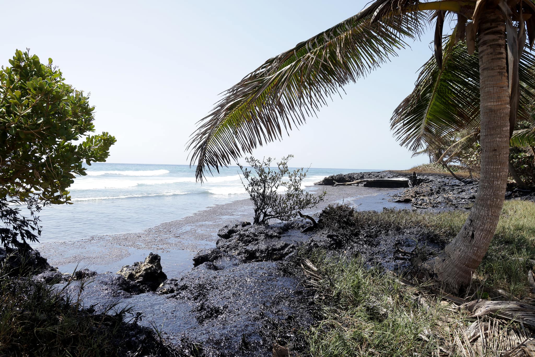
The team observed an oil-like substance entering the sheltered lagoon area in Petit Trou, inundating the sensitive mangrove ecosystem. “This once-thriving stand began exhibiting dieback prior to the spill incident and is now considered extremely vulnerable.”
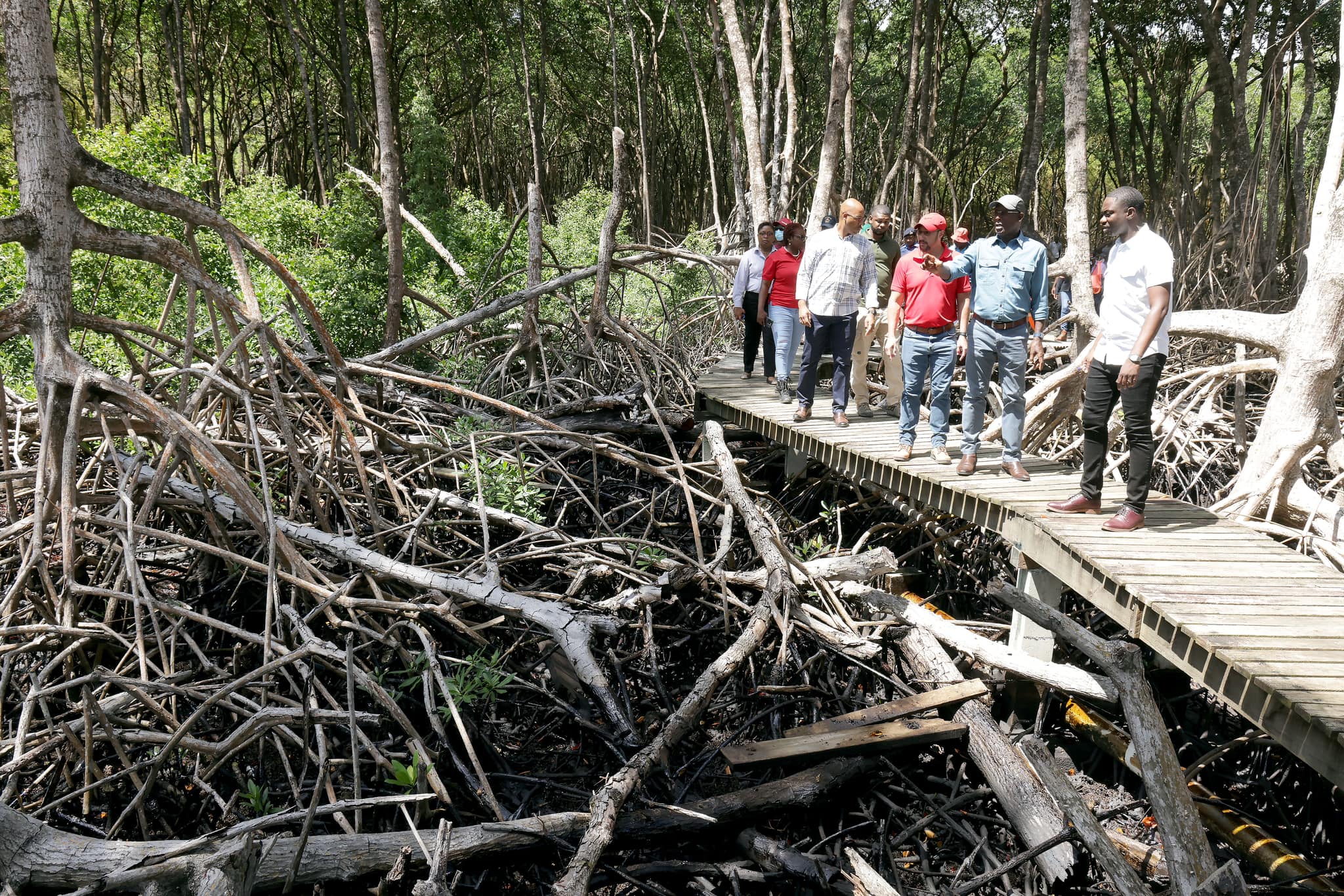
The IMA said the team, headed by IMA Director Dr Ava Maxam, met with the Chief Secretary of the Tobago House of Assembly, Farley Augustine, Allan Stewart, the Head of TEMA, Marc Rudder, Chief Technical Officer at the Ministry of Energy and Energy Industries, Gillian Stanislaus, Environmental Programme Officer II at the Environmental Management Authority in Tobago and other members of the response team, which comprised officials from Heritage Petroleum Company Limited, the Trinidad and Tobago Coast Guard and others, to report their initial findings and provide advice on how cleanup activities should proceed given that some of the affected areas are ecologically sensitive such as the nesting grounds of the critically endangered Hawksbill turtle.
On February 11th, 2024, the IMA also collected samples for oil fingerprinting, that is, to determine whether there is a link between impacted areas and effluent emanating from the source at the overturned vessel.
It said this is in addition to samples previously received on February 8th from The Trinidad and Tobago Coast Guard. Along with oil fingerprinting, samples will be continuously processed for dissolved and dispersed petroleum hydrocarbons (DDPH) to determine the concentration of hydrocarbons in the water column over time until results indicate a return to pre-incident levels. “This monitoring will form part of IMA’s plan to recover and restore the affected sites.”
The vessel’s origin and capacity still remain a mystery
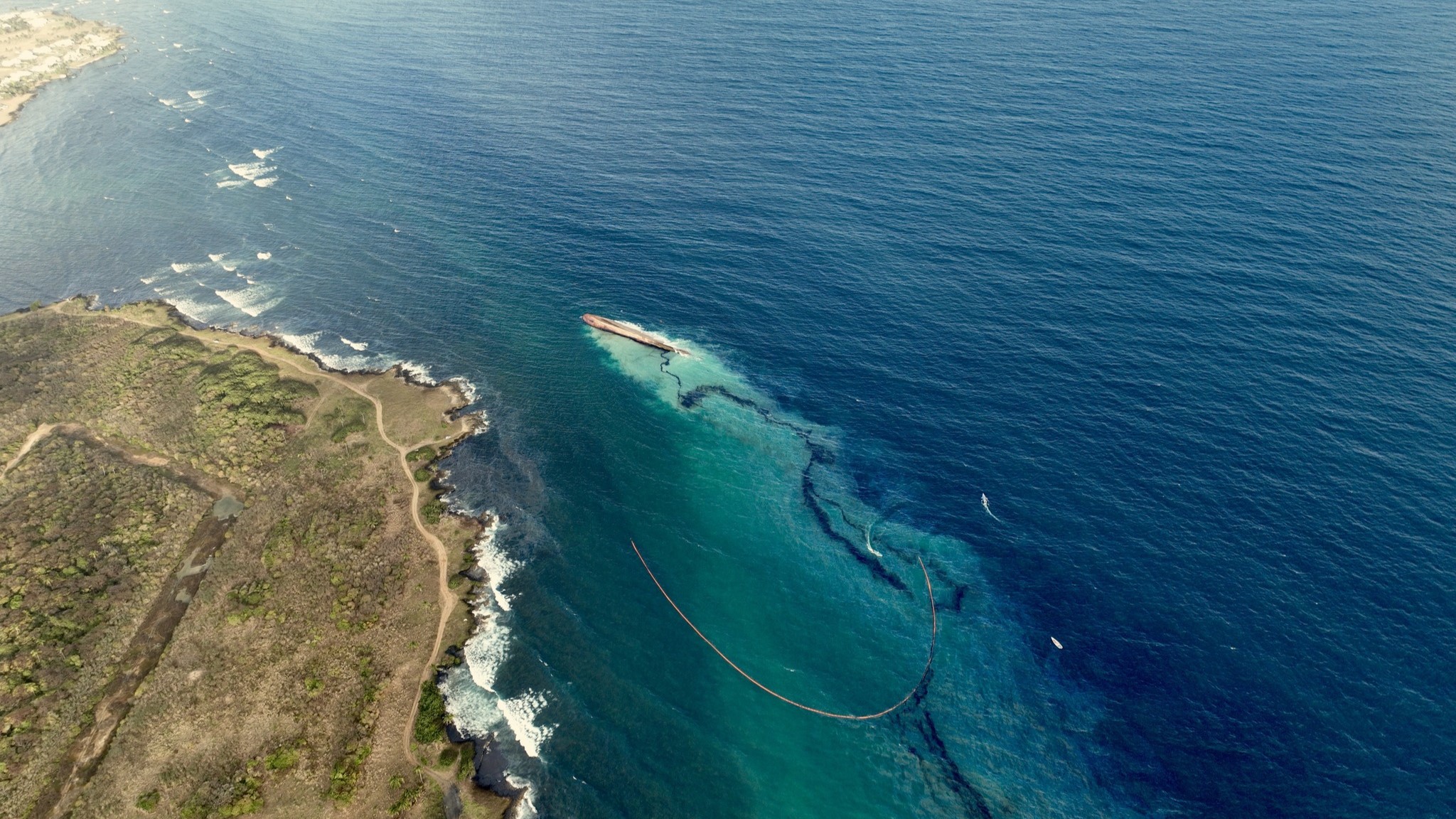
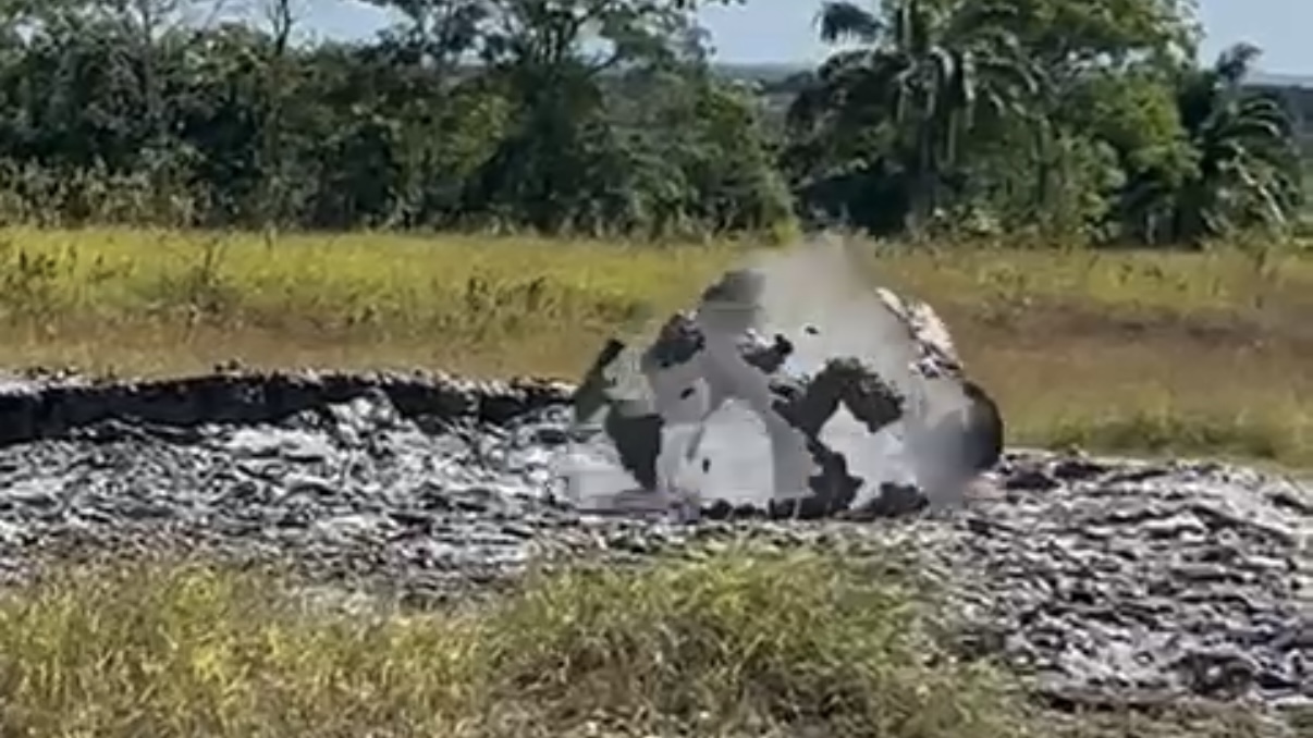
It has now been six days since an unidentified vessel ran around Cove Reef, south of Cove, Tobago, spilling an unknown volume of an unknown oil-like substance along Tobago’s windward coastline.
So far, divers were able to ascertain the vessel’s name – Gulfstream – but that is all the information officials have to work with. The International Maritime Organization (IMO) number was not visible, likely due to the moving, submerged vessel hitting against the reef, kicking up sediment for divers to see. The IMO number will give the vessel’s registration, which can then be used to determine the owner, previous names, ship capacity and intended use.
On Saturday, remote-controlled vehicles fitted with cameras inspected the ship, and no IMO number or any other identifying information was discovered.
Tobago House of Assembly Chief Secretary Farley Augustine said on Saturday at a media conference: “Let me tell you before you ask that we still have not been able to identify the vessel by name. There may be some identifying characteristics. And notwithstanding using ROVs, we have not been successful in identifying an IMO number. So the next task is to use infrared to more or less identify the structure of the vessel and to see what is contained there.”
T&T’s Prime Minister, Dr Keith Rowley, said at the same media conference: “We have had no record of it. And that’s as much as we know; now we are checking the Coast Guard radar equipment in the days ahead, prior to seeing whether, in fact, it was missed. Clearly, if they were operatives in and around who had distress, one would expect that they would have communicated to the relevant authorities. We have no information of any such distress, assuming that the vessel was operating in our zone.”