


For the first time since 2017, Trinidad and Tobago has officially been placed under a Hot Spell Warning as sweltering heat is in the forecast for the country. It is also the longest the country has ever been officially placed under such a warning in the history of the Trinidad and Tobago Meteorological Service, with the warning in effect for 15 days through September 29th.
What you need to know
— What has happened: Over the last few weeks, Trinidad and Tobago has experienced elevated levels of heat, occasionally surpassing the definition for a hot day at both Piarco (maximum temperatures at or above 34°C) and Crown Point (maximum temperatures at or above 33°C). On Friday, with consecutive hot or near hot days forecast, the TTMS placed the country under a Hot Spell Warning, the first such early warning message since 2017.
— What is expected: Maximum high temperatures near or above 34°C in Trinidad and at or above 32.5°C in Tobago are forecast through the end of September. However, across western and urbanized areas of the country, maximum high temperatures could reach as high as 38°C and even higher in cities. The TTMS is forecasting heat index values between 34°C and 44°C, but based on what T&T has experienced already, heat indies between 37°C and 53°C are likely.
— Hazards: There is a real threat of heat exhaustion and heat stroke amongst the population, with heat stress likely for crops and animals.
Latest Alerts

High Wind Alert Remains In Effect For T&T
Trinidad and Tobago is NOT under any tropical storm or hurricane threat, watch, or warning at this time.
The Hot Spell Warning
Officially, according to the TTMS, a hot spell is declared when Trinidad and Tobago experiences maximum high temperatures reach or exceed 34°C at Piarco AND maximum high temperatures reach or exceed 33°C at Crown Point, Tobago. Historically, the maximum high-temperature threshold for Tobago was at or above 32°C, but this was changed in August 2023, as the definition of a hot day is meant to capture maximum high temperatures in the top 95th percentile of temperatures and, according to the TTMS climatologist office, 32°C was too low. Hot spells are the same as heat waves.
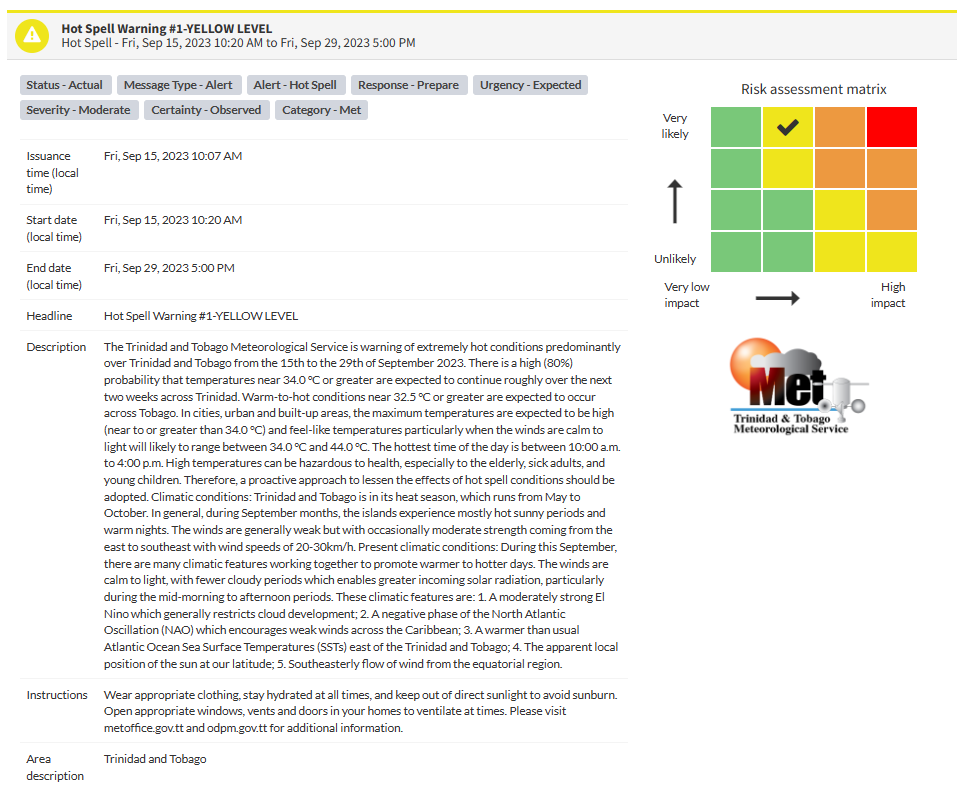
The Trinidad and Tobago Meteorological Service issued the Hot Spell Warning (Yellow Level) on Friday at 10:07 AM, which went into effect shortly after at 10:20 AM Friday, September 15th, 2023. The warning remains in effect for the next two weeks until Friday, September 29th, 2023, for both Trinidad and Tobago.
Trinidad and Tobago is not under any tropical storm watch or warning at this time.
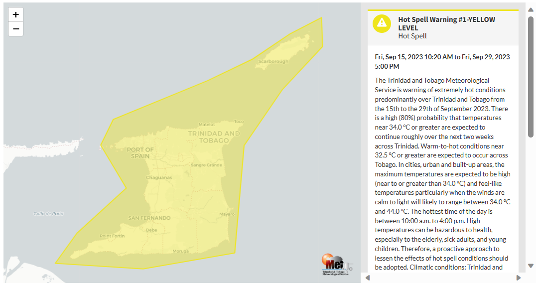
The TTMS is warning of extremely hot conditions, predominantly over Trinidad and Tobago, from the 15th to the 29th of September 2023. According to the TTMS:
- There is a high (80%) probability that temperatures near 34.0°C or greater are expected to continue roughly over the next two weeks across Trinidad.
- Warm-to-hot conditions near 32.5°C or greater are expected to occur across Tobago. In cities, urban and built-up areas, the maximum temperatures are expected to be high (near to or greater than 34.0°C).
- Feel-like temperatures (or heat indices), particularly when the winds are calm to light, will likely range between 34.0°C and 44.0°C, especially during the hottest time of the day between 10:00 a.m. to 4:00 p.m.
- High temperatures can be hazardous to health, especially to the elderly, sick adults, and young children. Therefore, a proactive approach to lessen the effects of hot spell conditions should be adopted.

The color of the alert indicates the severity of the event and the probability of the event occurring. Currently, the alert level is Yellow. This means that the hazards have already been observed, and the severity of the impacts is moderate for this particular alert. You should be aware of the hazards associated with hot temperatures, including but not limited to heat stress, heat exhaustion and heat stroke among people, plants and animals.
For a moderate Hot Spell Warning, there is the potential for possible injuries, where behavioral changes are required to ensure safety. Generally, there may be minor damage to property, with income-earning temporarily disrupted and a couple of communities affected more than others.
The Met Office is advising the public to wear appropriate clothing, stay hydrated at all times, and keep out of direct sunlight to avoid sunburn, open appropriate windows, vents and doors in your homes to ventilate at times, as well as monitor weather conditions and updates from official sources.


What’s causing the excessive heat?
Since mid-August, multiple tropical cyclones have safely moved north of Trinidad and Tobago. The result of these stronger low-pressure systems traversing north of the region is weaker surface winds, coming from the southeast and south, to near calm and calm at times.
Though the mid to upper-level environment remains fairly dry, the low-level environment has marginal amounts of moisture, which leads to elevated humidity. As a result, high amounts of warm air remaining near the surface, while at night, occasional mid/upper-level clouds prevent the escape of heat into the atmosphere.
The result is warm, humid nights and hot, humid days across not only Trinidad and Tobago but the remainder of the Lesser Antilles.
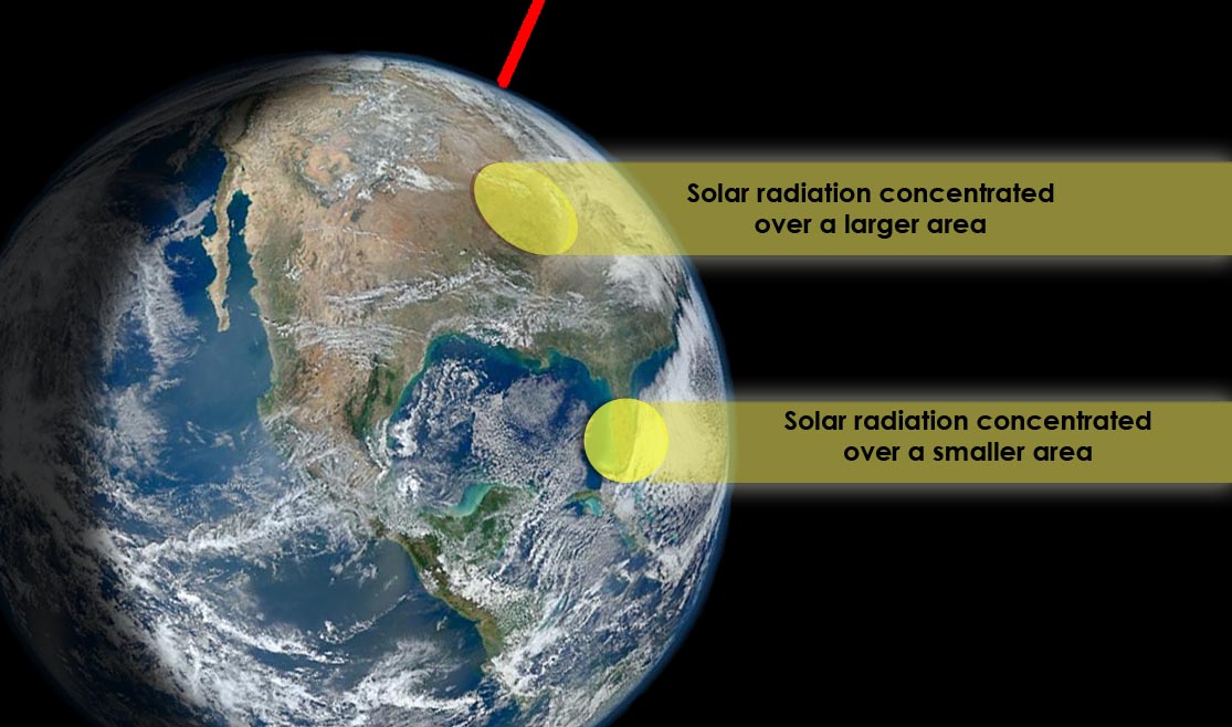
On a larger scale, the solar altitude, or the angle of the sun relative to the Earth’s horizon, is at 90° across T&T (occurred on August 25th). When this occurs, solar radiation is concentrated over a smaller surface area, causing warmer temperatures.
Trinidad and Tobago is also entrenched in its heat season, which runs from March to October, with the first peak in April and May and the second peak in late August through early October. During these months, the islands experience mostly hot sunny periods and warm nights. Winds are generally weak but occasionally moderate strength from the east to southeast with speeds of 20-30 KM/H.
According to the Met Office, there are many climatic features working together to promote warmer to hotter days this month. “The winds are calm to light, with fewer cloudy periods, which enables greater incoming solar radiation, particularly during the mid-morning to afternoon periods:
- A moderately strong El Nino which generally restricts cloud development.
- A negative phase of the North Atlantic Oscillation (NAO) encourages weak winds across the Caribbean.
- A warmer than usual Atlantic Ocean Sea Surface Temperatures (SSTs) east of the Trinidad and Tobago.
- The apparent local position of the sun at our latitude.
- The southeasterly flow of wind from the equatorial region.


