


What began as welcome rainfall after an extremely dry April turned into a deluge no one needed. Parts of Trinidad and Tobago saw an average April’s worth of rainfall daily for three consecutive days, causing significant flash flooding that swept away multiple vehicles. Thankfully, there has been no loss of life to date.
Latest Alerts

Adverse Weather Alert Discontinued, Moderate Impacts Still Possible
Trinidad and Tobago is NOT under any tropical storm or hurricane threat, watch, or warning at this time.
What happened?
Since Sunday, April 23rd, 2023, Trinidad and Tobago has remained near the western periphery of a high-pressure system, with a deep flow of moisture from equatorial South America. A number of factors came together to support an induced low-level trough west of T&T, with the area under several favorable atmospheric features that supported shower and thunderstorm development.
The first rounds of rains came on Sunday, with the first on-shore thunderstorm for 2023 affecting northwestern Trinidad between 11:30 AM and 12:20 PM, producing heavy rainfall rates that triggered street/flash flooding across northwestern Trinidad, where the highest overall rainfall was recorded. Additional showers moved across both islands. By the evening, another isolated thunderstorm moved onshore southern Trinidad around 7:40 PM.
Then, on Monday, multiple thunderstorms developed across northwestern, central, and southern Trinidad throughout the afternoon into the evening, producing rainfall totals as high as 122 millimeters per hour in some parts of Trinidad.
Afternoon thunderstorms also affected flights at the Piarco International Airport, where visibility dropped below one kilometer from 2:23 p.m., dipping as low as 500 meters at 3:00 p.m. This drop in visibility caused BW1517, a Caribbean Airlines flight from Tobago, to circle the airport, forcing it to return to Crown Point to refuel before finally landing in Trinidad hours after its scheduled arrival.
Similar to Sunday, most of the flooding occurred in northwestern Trinidad, accounting for 27 of the 30 flood reports received that day. Flooding also occurred in Tunapuna, Claxton Bay, and Maloney, where multiple vehicles were inundated.
By Tuesday, the atmosphere was saturated and unleashed a deluge of rainfall across mainly eastern Trinidad, though the remainder of the country received notable rainfall amounts. Between 3:00 AM and 4:00 AM, parts of northeastern Trinidad saw consistent rainfall rates above 100 millimeters per hour. By 8:30 AM, the Trinidad and Tobago Meteorological Service issued their first Adverse Weather Alert, but the worst of the weather had already occurred, with several parts of the country already underwater.
Update: On Wednesday, as forecast, showers and thunderstorms materialized across Trinidad and Tobago, dumping significant rainfall across northern Trinidad and producing flash flooding in various areas. Flooding rose in parts of northeastern Trinidad for another day while the Caroni River was pushed to capacity.
[Updated] 13 out of 14 Municipal Corporations affected
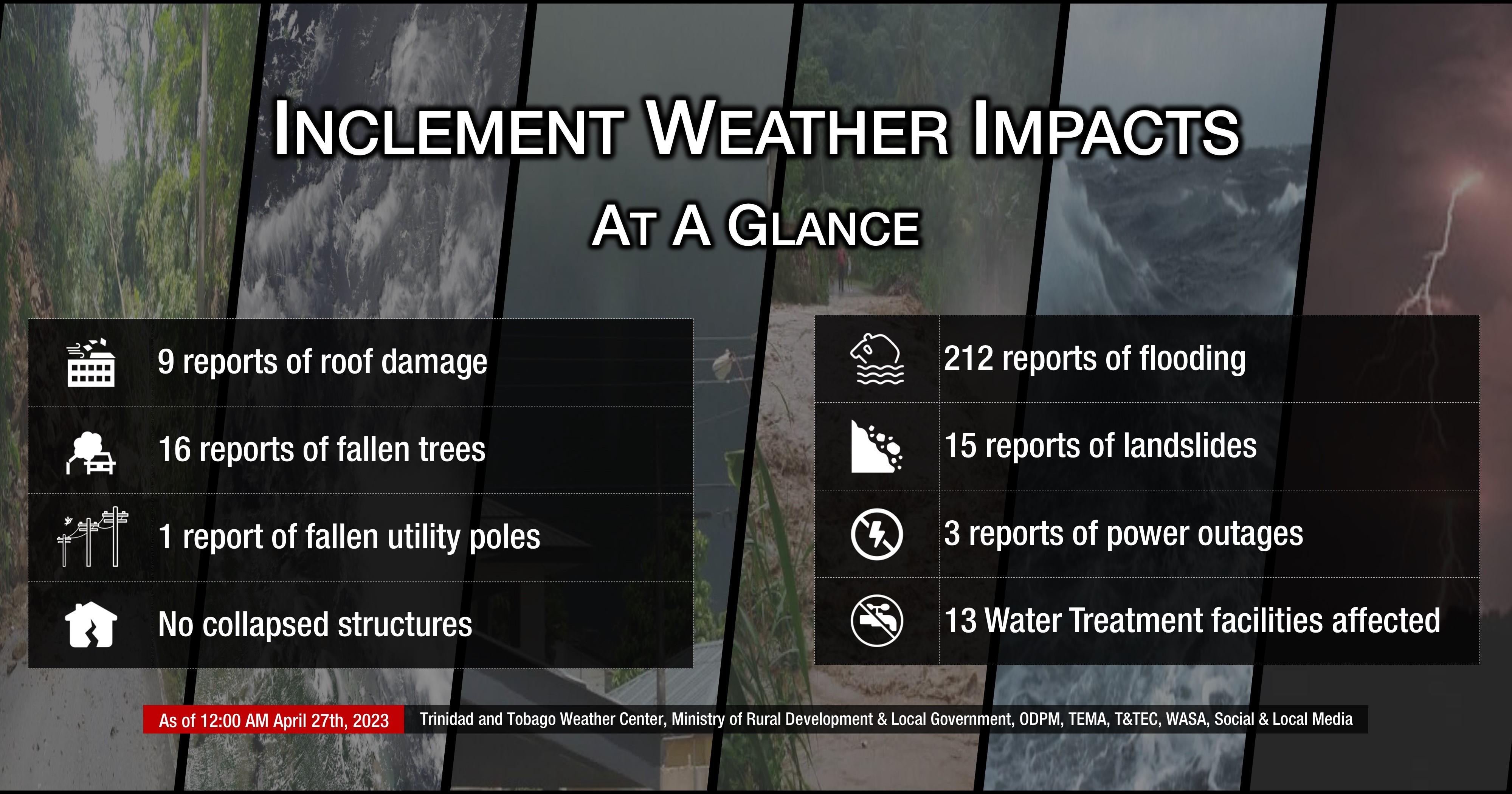
By the end of Wednesday, heavy rains affected across both islands and caused some form of hazardous weather impact in 13 of the 14 municipal corporations in Trinidad. The Chaguanas Borough Corporation and the Tobago Emergency Management Agency were the only two municipal areas not to report any impacts. As of 12:00 AM Thursday, there have been 252 inclement weather reports comprising of flooding, wind damage, fallen trees/utility poles, landslides, and damaged structures.
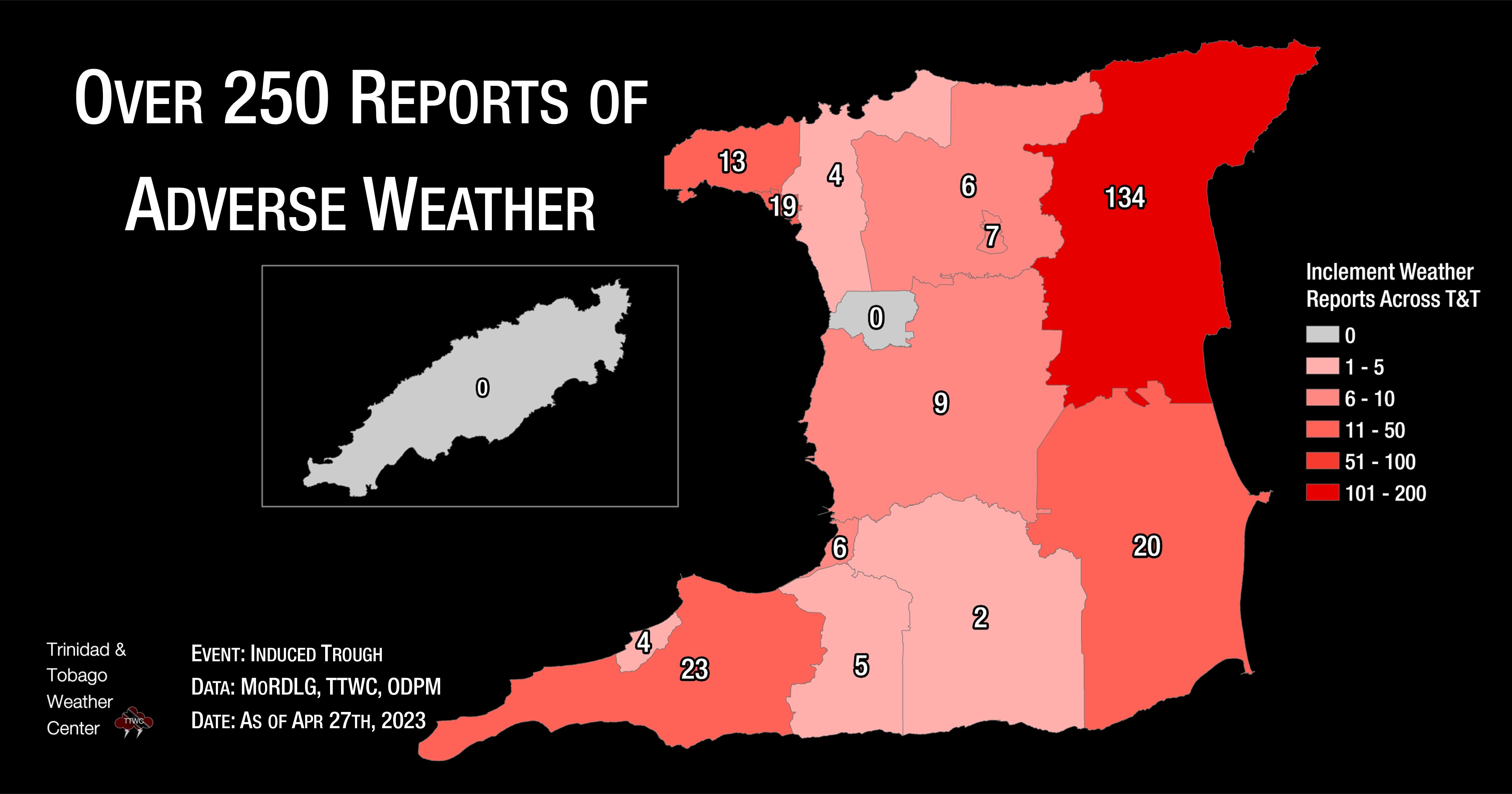
The Sangre Grande Regional Corporation was the worst affected, with 134 reports, 117 of which were flooded areas. The Siparia Regional Corporation and the Mayaro-Rio Claro Regional Corporation were the next hardest hit, with 23 and 20 reports respectively, most of which were flooding.
The Breakdown
As of 12:00 AM Wednesday, April 26th, 2023. This would have accounted for the 150+ events prior, which increased substantially during the day on Wednesday.
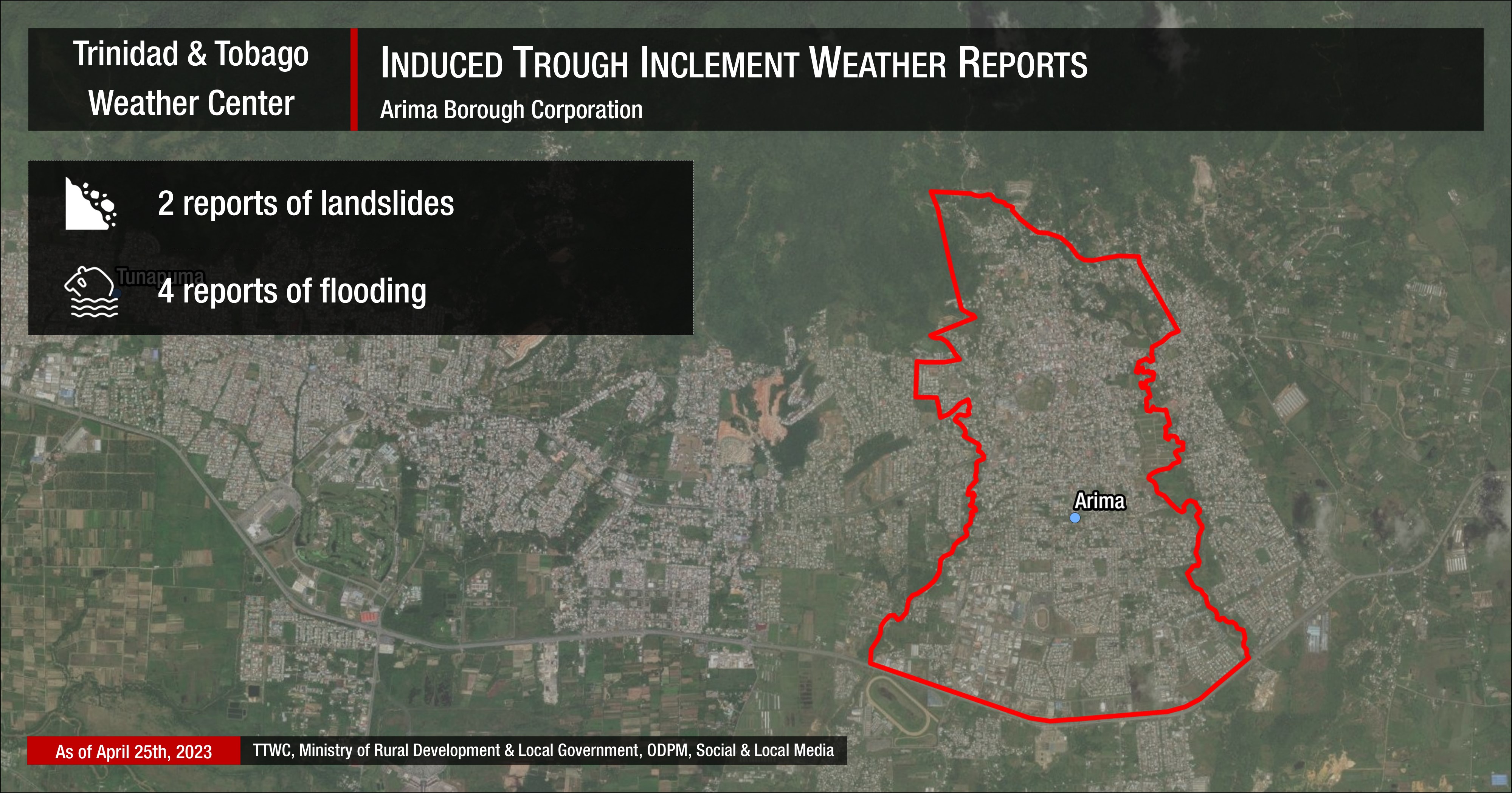
Arima Borough Corporation: Street flooding generally affected the area, with the most severe flooding occurring on Monday, where several vehicles stalled in flood waters.
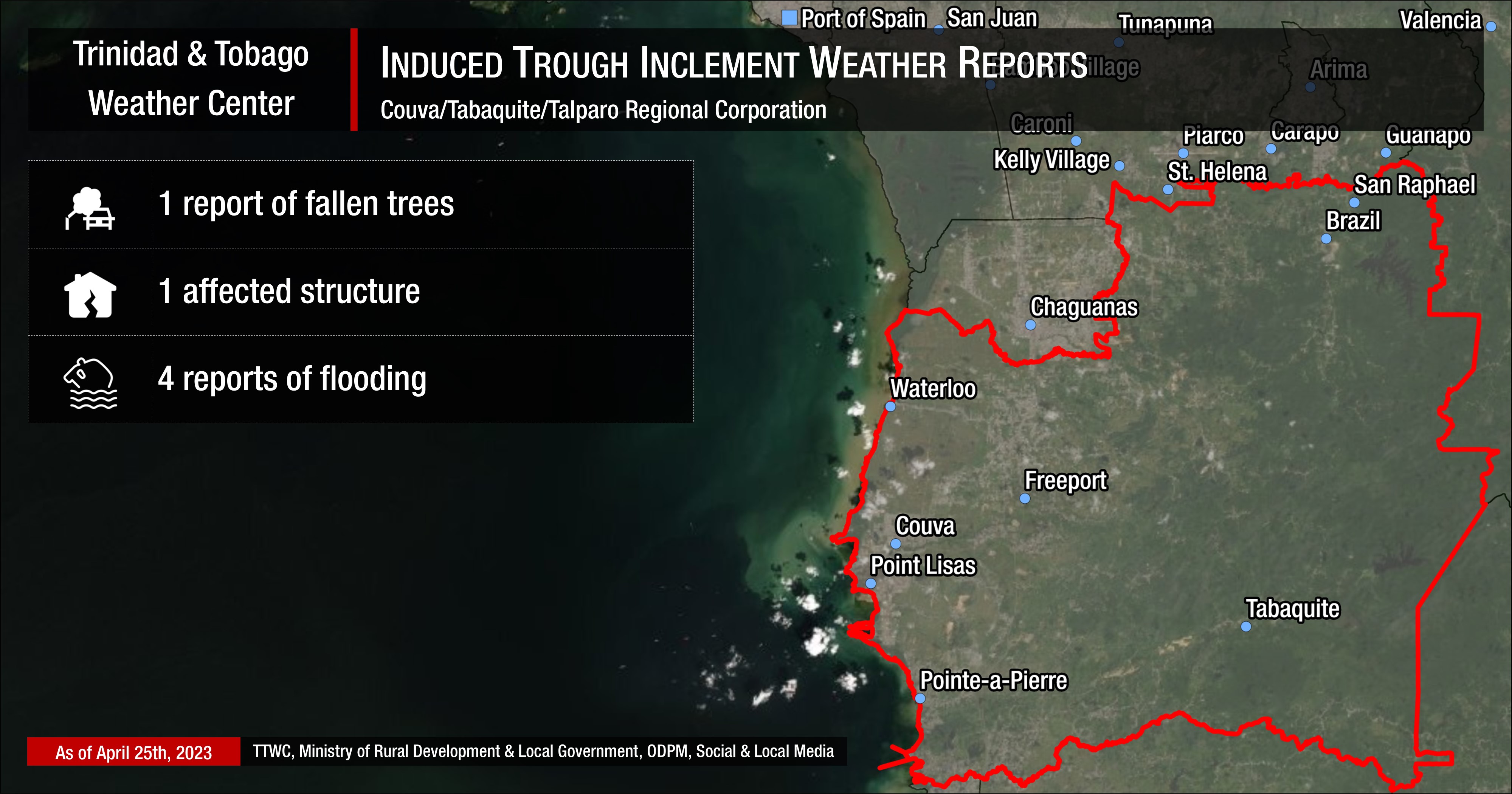
Couva/Tabaquite/Talparo Regional Corporation: Flooding occurred on the Southern Main Road and Cedar Hill Road, Claxton Bay, with residential flooding reported at Joyce Road, and a fallen tree at the San Salvador Estate road. A roof also collapsed at a home along Cedar Hill Road, Claxton Bay.
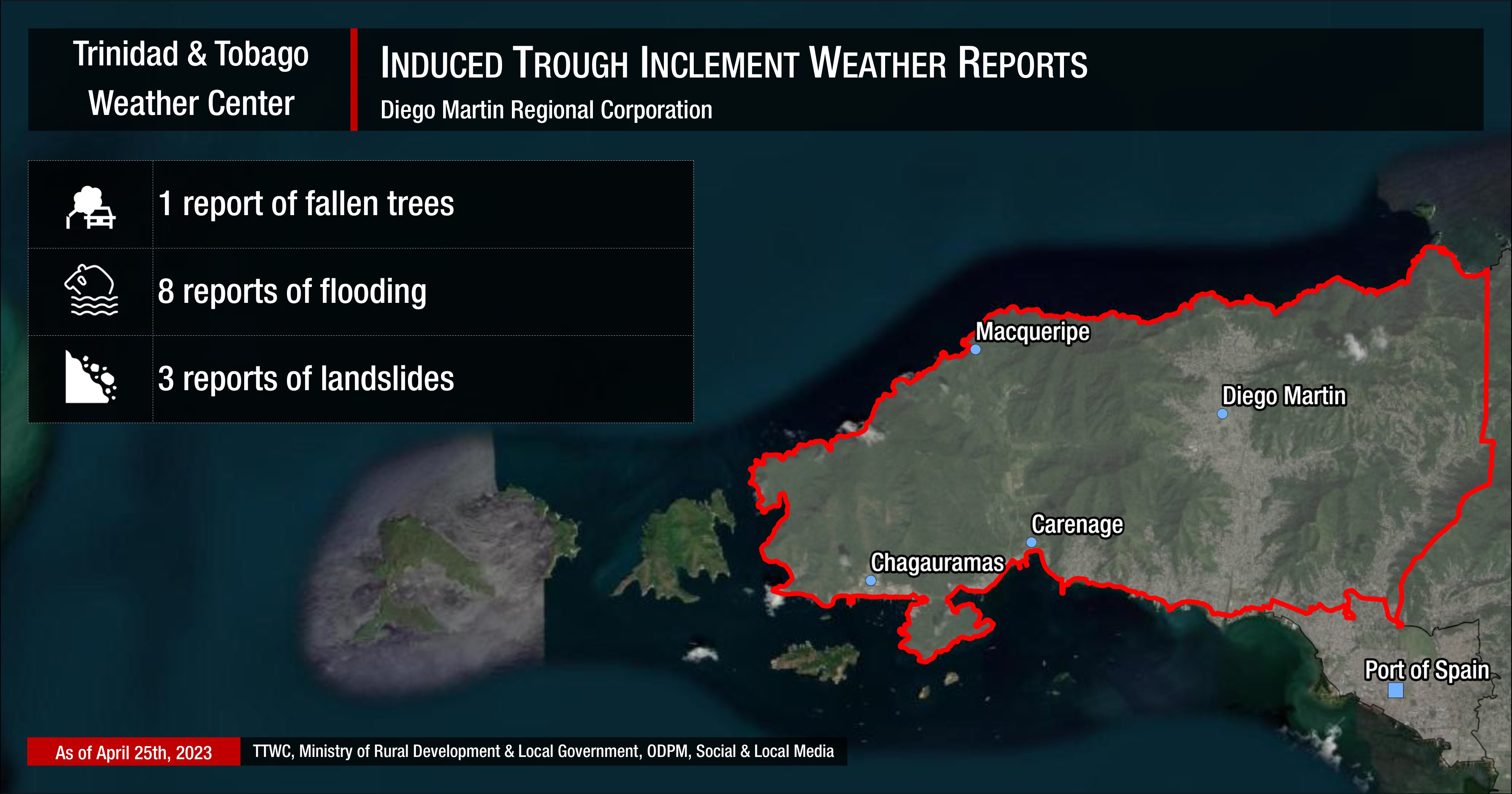
Diego Martin Regional Corporation: Most of the flooding occurred on Sunday, April 23rd, 2023, within the Diego Martin area and along the Western Main Road. Landslides and fallen trees occurred on Tuesday, April 25th, 2023.
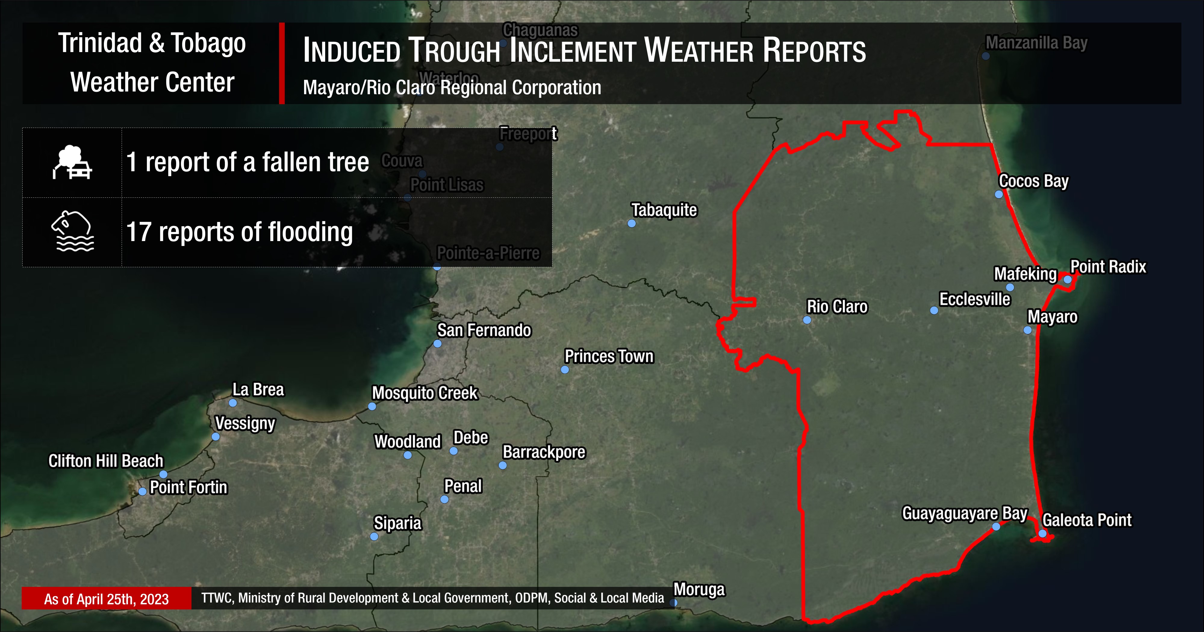
Mayaro/Rio Claro Regional Corporation: Several reports of street and flash flooding affected parts of Union and Bristol Village, with fallen trees in Biche.
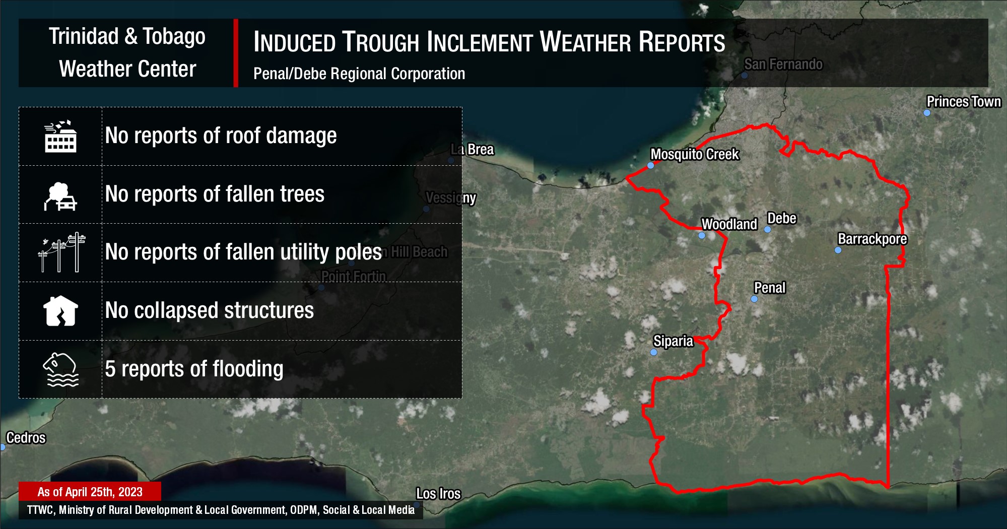
Penal/Debe Regional Corporation: Flooding was reported at Crawford Trace, Kay Trace, Mendez Village, Scott Road Junction at Penal Rock Road, and Warden Road.
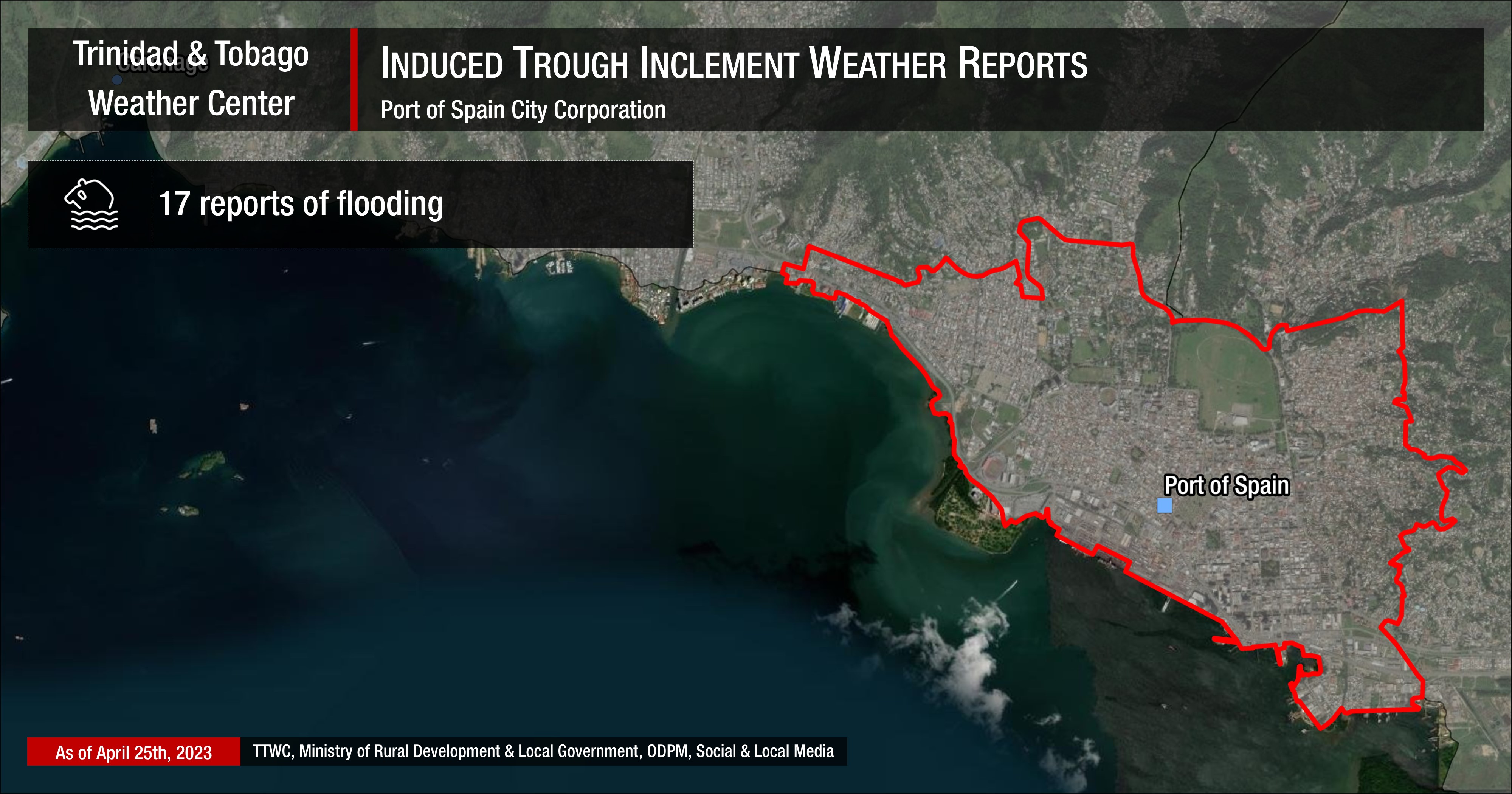
Port of Spain City Corporation: Flooding occurred on Monday, April 24th, 2023, with most of the flood reports coming in from lower Port of Spain.
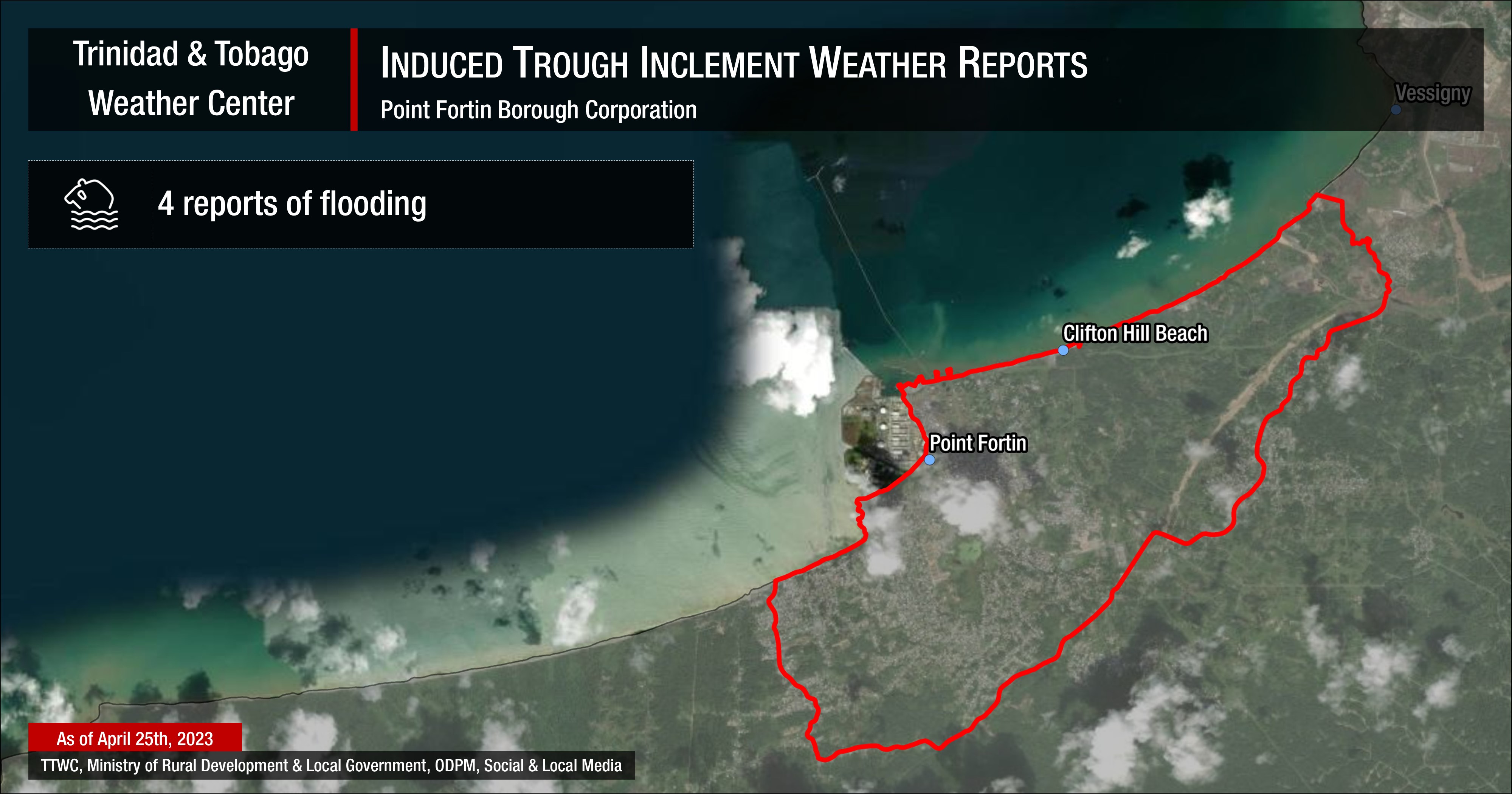
Point Fortin Borough Corporation: Flooding reported at the Egypt Main Road near Mervyn Cato Drive, Jattan Trace, Egypt Village, and Southern Main Road near Point Fortin Indoor Arena.
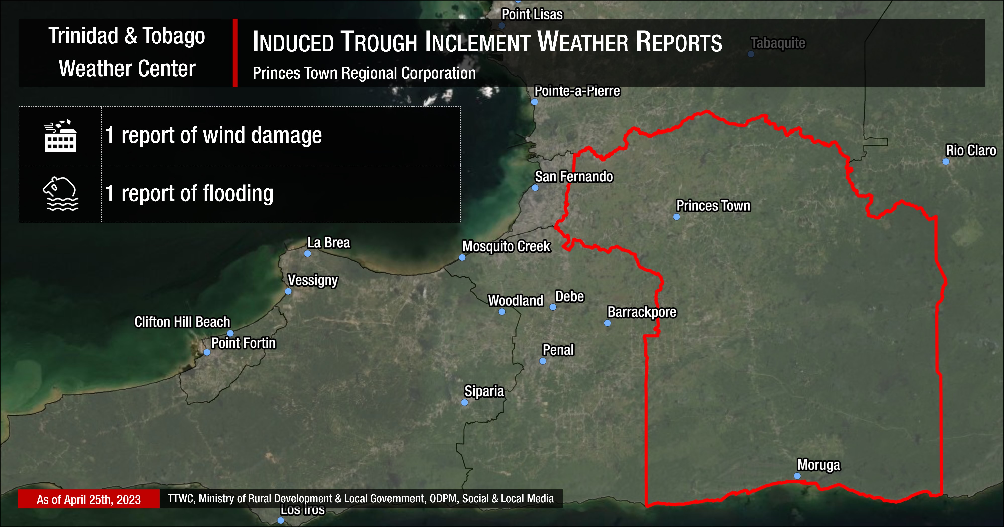
Princes Town Regional Corporation: Flooding was reported at Mt. Stewart Village on Tuesday, with one structure affected by winds.
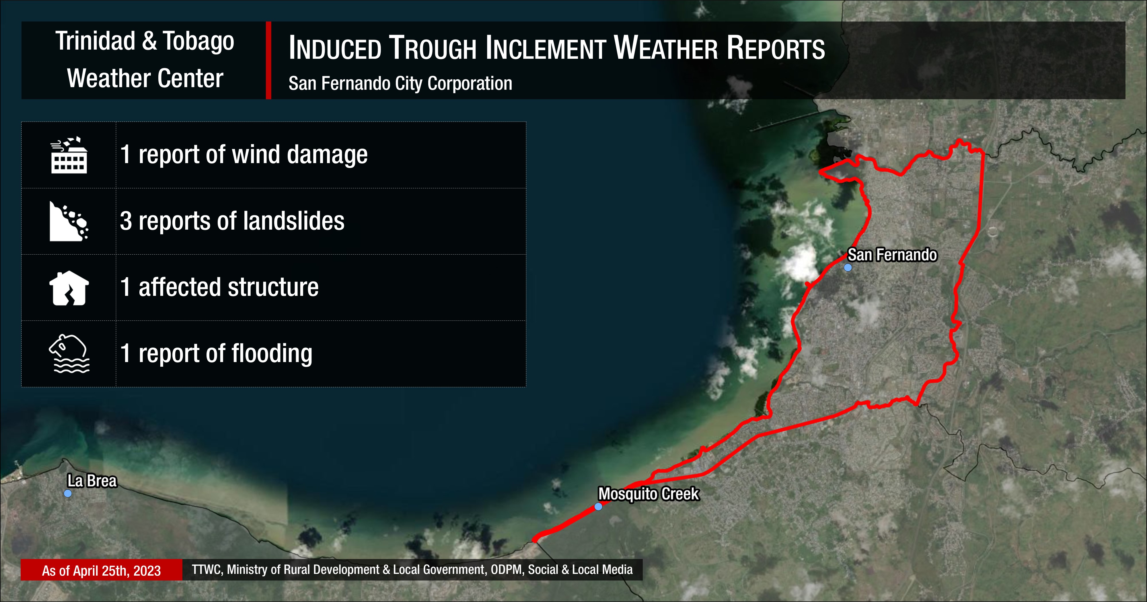
San Fernando City Corporation: Flooding at Industrial Lane, Marabella, with multiple landslides reported within SFCC area.
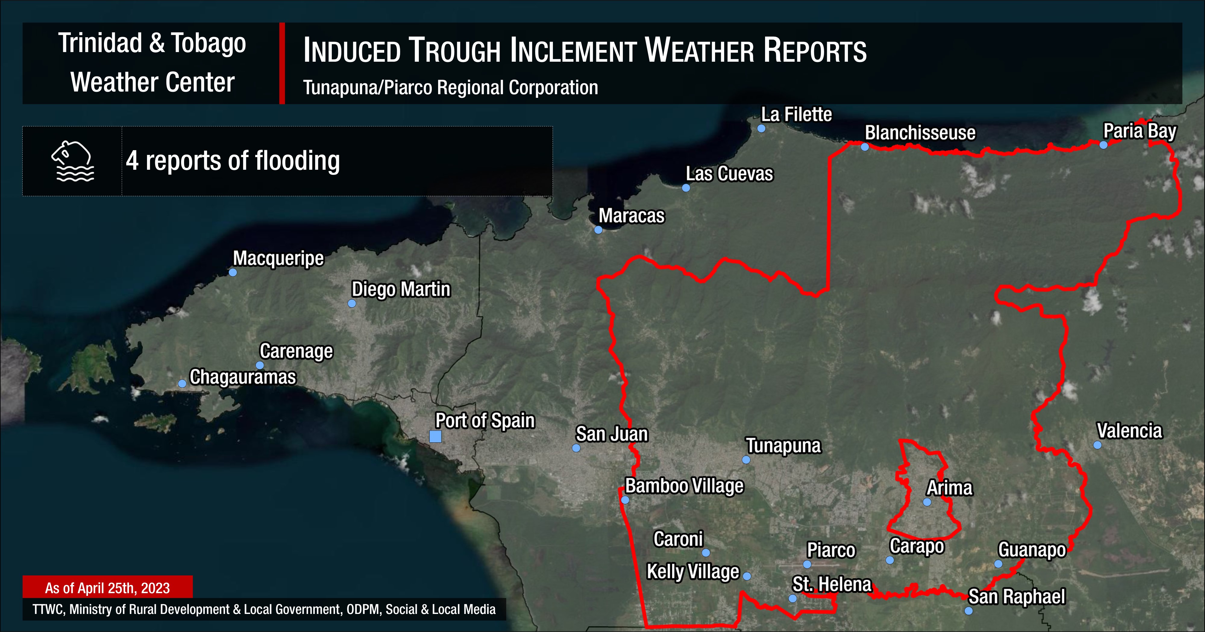
Tunapuna/Piarco Regional Corporation: Four reports of flooding.
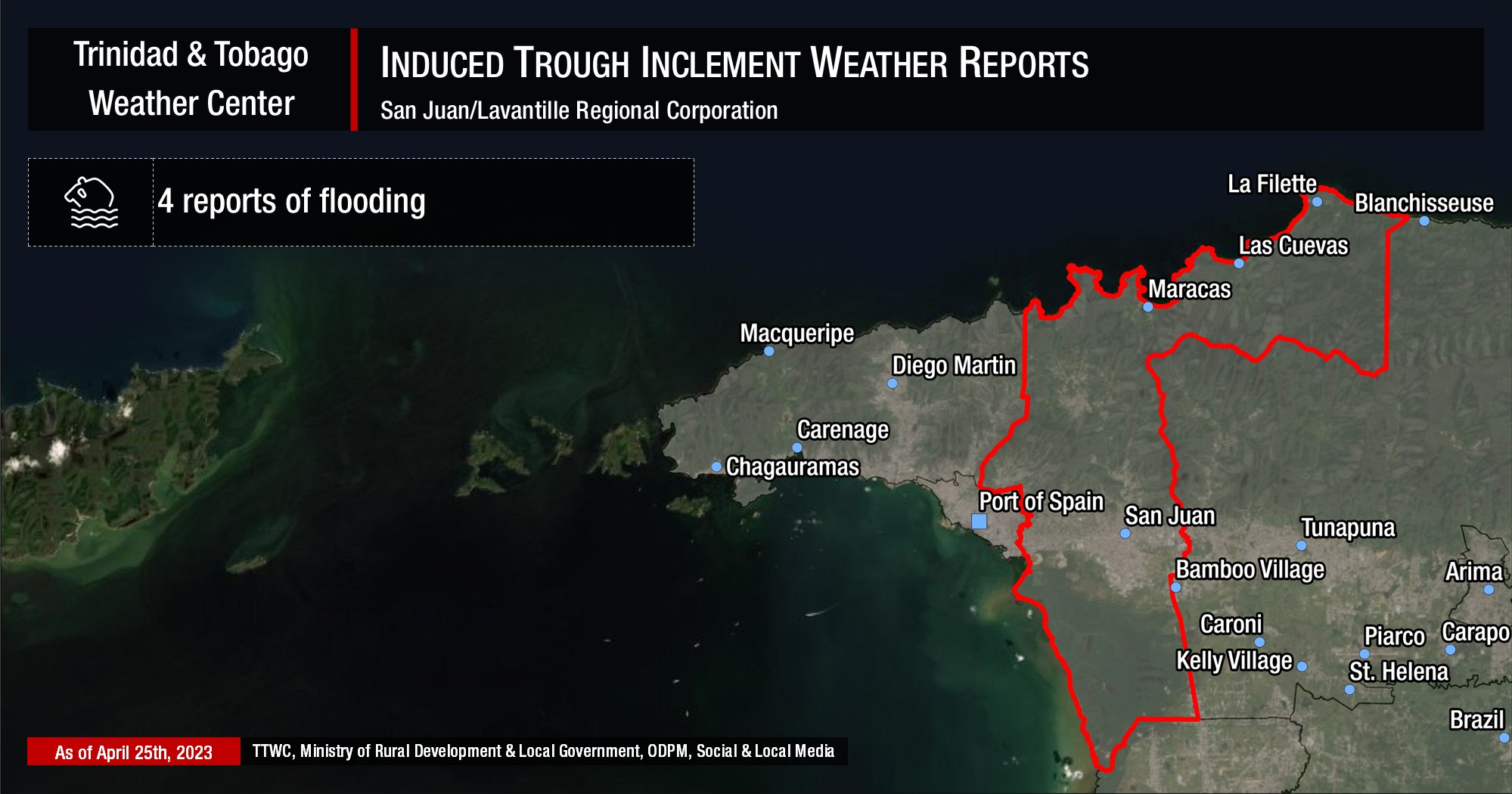
San Juan/Lavantille Regional Corporation: Flooding along the Eastern Main Road and in St. Ann’s on Monday, with a landslide and fallen tree at Sam Boucaud in Santa Cruz on Tuesday.
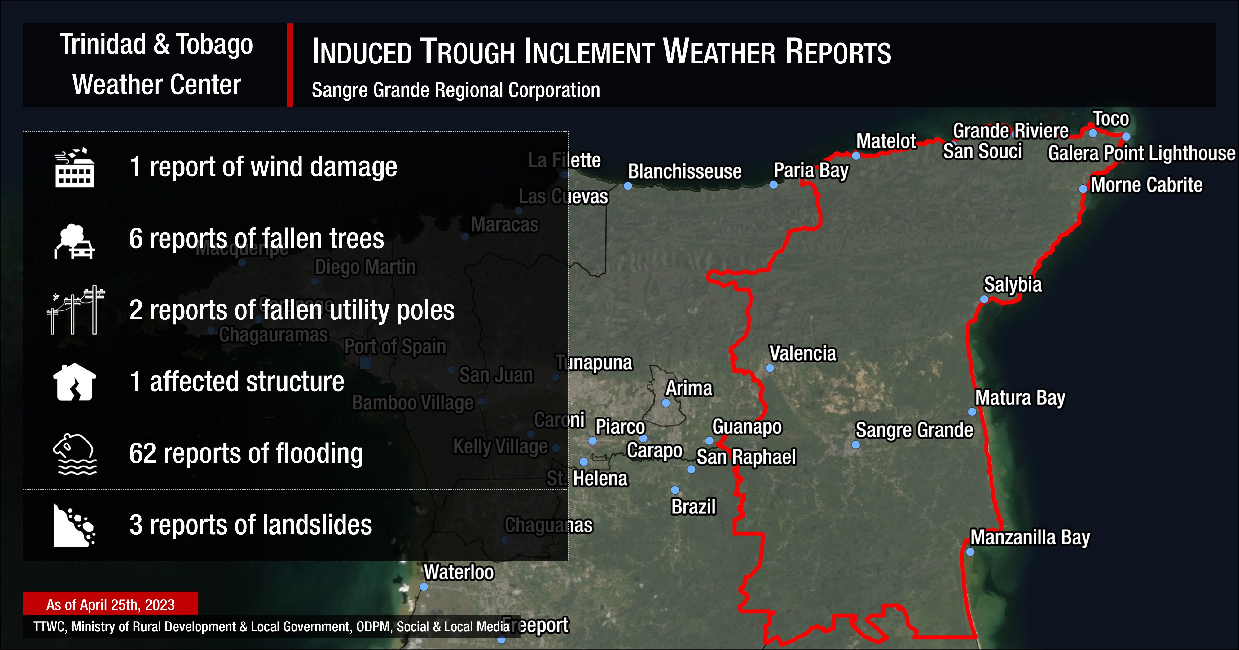
Sangre Grande Regional Corporation: The worst affected area of Trinidad, with 62 reports of flooding across the corporation. Most of the severe flash floods occurred near the town of Sangre Grande and near the Cunapo and North Oropouche Rivers.
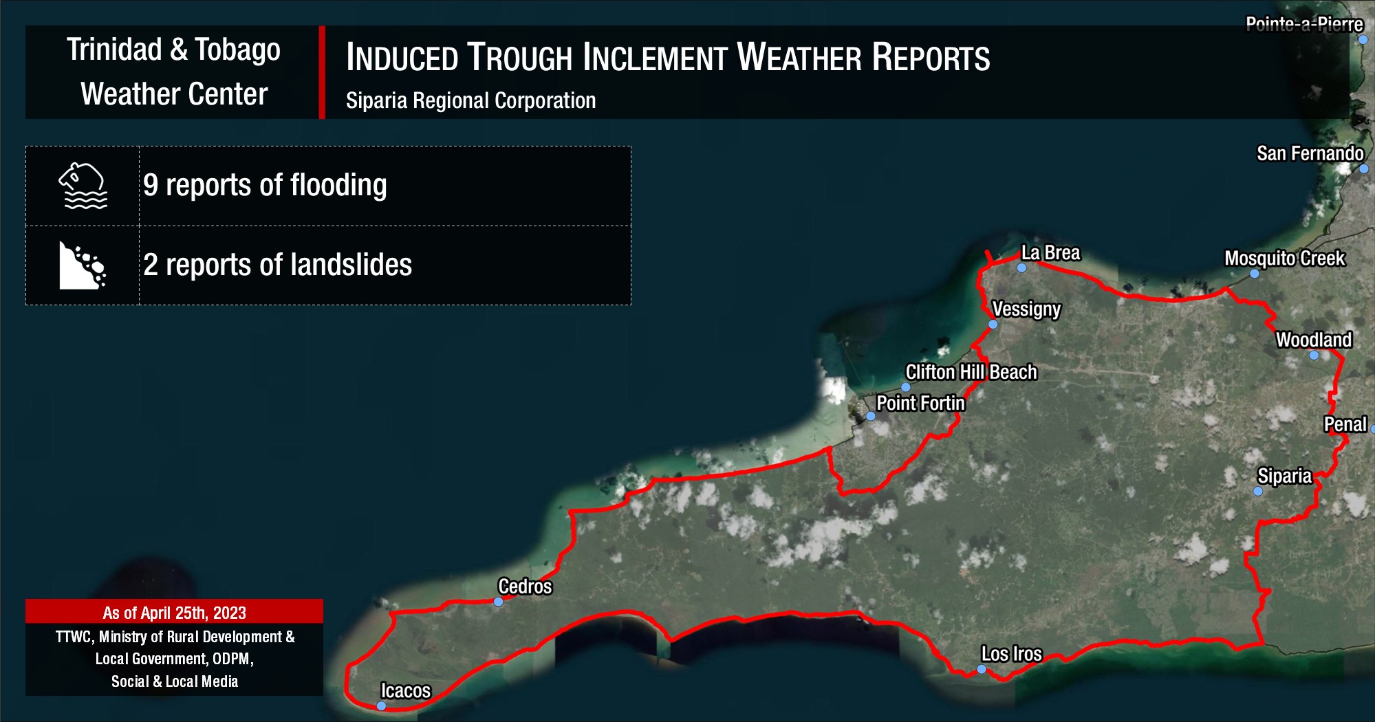
Siparia Regional Corporation: Flooding at Agapito Trace, Santa Flora, August Joseph Road, Coora Settlement Trace, Gonzales Road, Quarry Village, SS Erin Road between Francis Trace and Alexander Village, with residential flooding at Coora Settlement Trace, Erin Road, and Warden Road. A landslide also occurred a Coora Settlement Trace.
[Updated] A month’s worth of rain in hours
While the overall rainfall accumulations daily were fairly well forecast, the amount of rain that fell consistently exceeded model guidance, taking some by surprise.
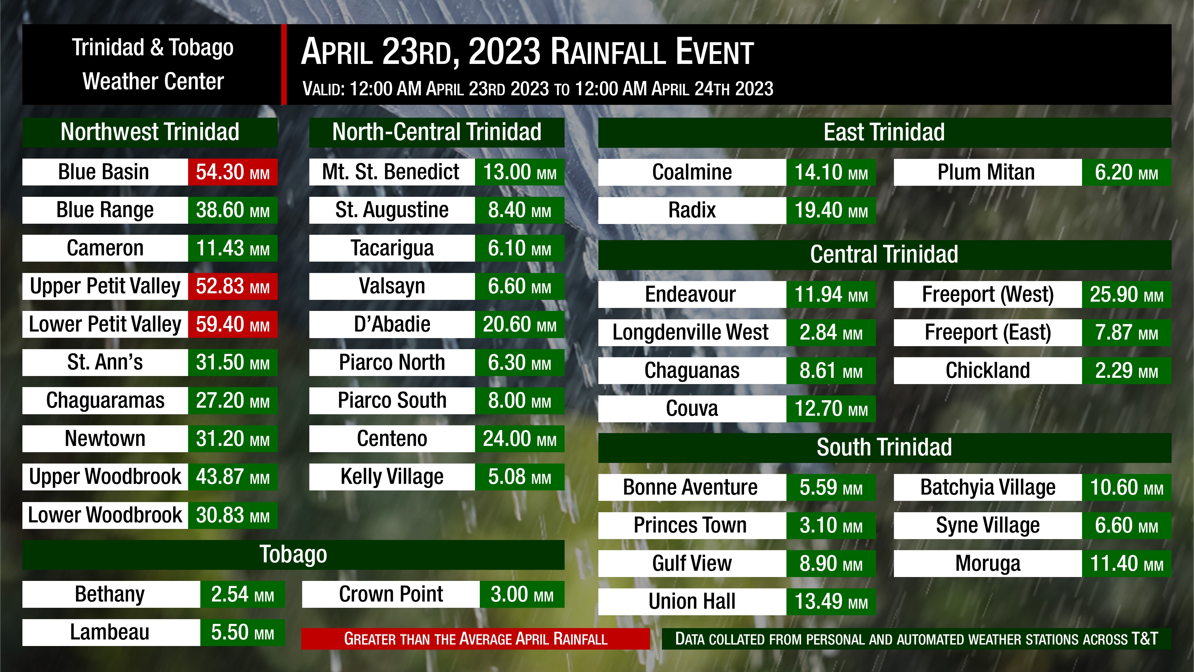
On Sunday, generally, between 5 and 15 millimeters of rainfall were recorded across both islands. The heaviest rains focused on northwestern Trinidad, occurring between 11:00 AM and 3:00 PM, producing rainfall totals nearing 60 millimeters in the wettest areas. The average rainfall at Piarco for the month of April comes in at 51.6 millimeters, meaning parts of Diego Martin recorded more than a month’s worth of rainfall inside a few hours. This was the beginning of a pattern that would carry on through the next two days.
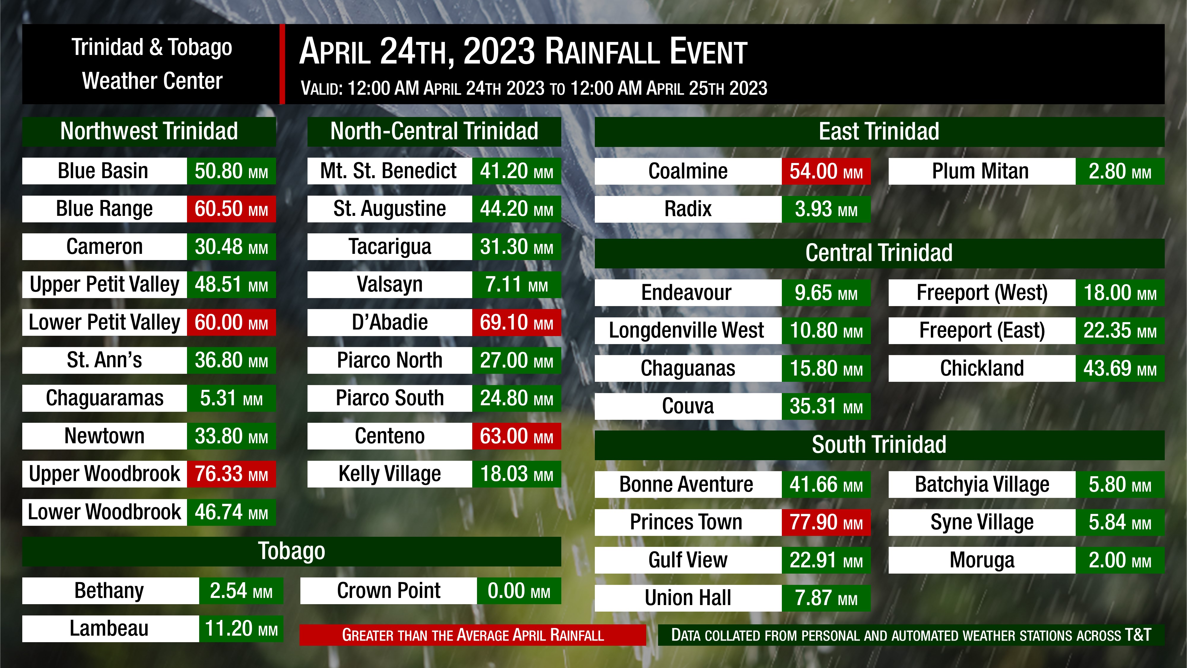
On Monday, the rainfall was more widespread, with showers and thunderstorms moving from the south to the north, generally across Trinidad, while Tobago remained fairly dry. Rainfall accumulations reached as high as 80 millimeters in some areas, with six different weather stations in northwest, north-central, east, and south Trinidad surpassing the average rainfall for April that has been recorded at Piarco.
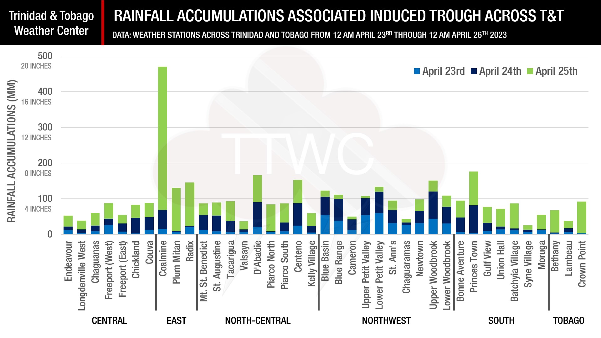
However, after midnight on Monday into Tuesday, this is when Trinidad and Tobago saw the bulk of the rain from this inclement weather event. Most areas recorded between 15 and 50 millimeters of rainfall on Tuesday, with multiple weather stations recording upwards of 100 millimeters. The largest rainfall accumulation, based on publicly reporting weather stations, occurred at Coalmine, Sangre Grande, with a whopping 401.90 millimeters recorded in a 24-hour period.
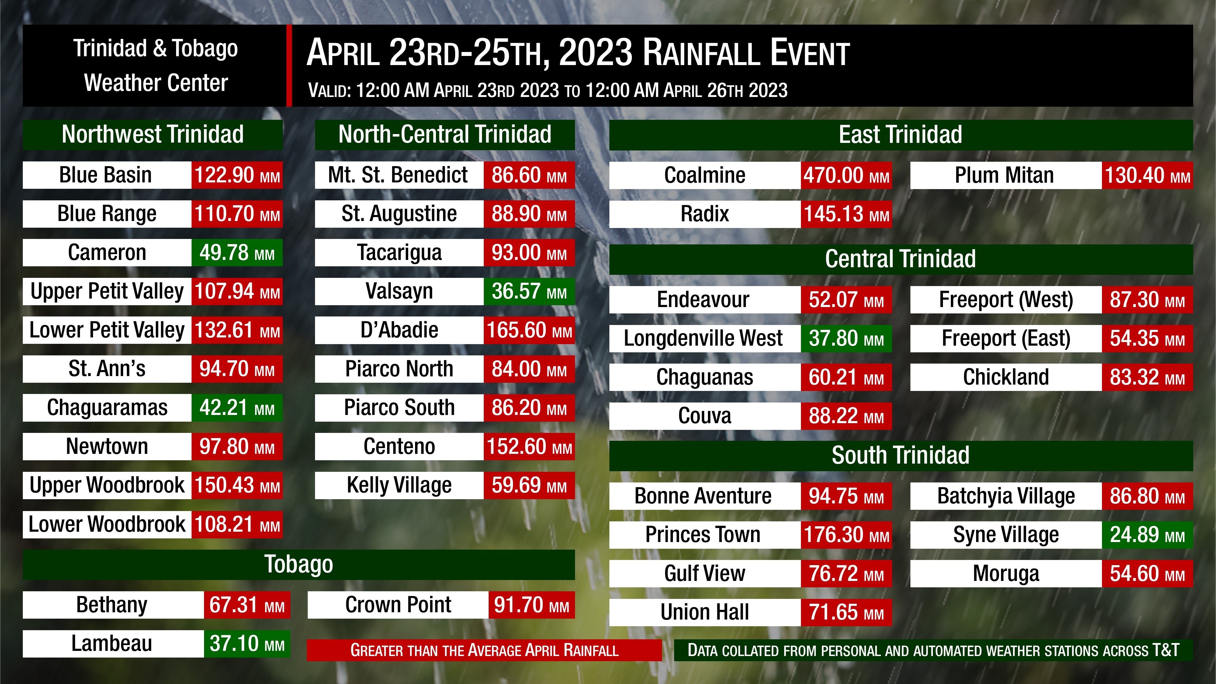
This level of rainfall, in a short time frame, is typically not seen outside of tropical cyclones. We’ve been in contact with the owner of this weather station, and it was recently installed, calibrated, and properly set up, standing at 11 feet, 2 inches above the ground, away from structures and other infrastructure/fauna that could have contaminated the reading. This meant that parts of Sangre Grande recorded nearly eight times the average monthly rainfall in just under 12 hours, as most of the rains subsided by midday. The result was significant flooding, which is reflected in the hazardous weather impact reports.
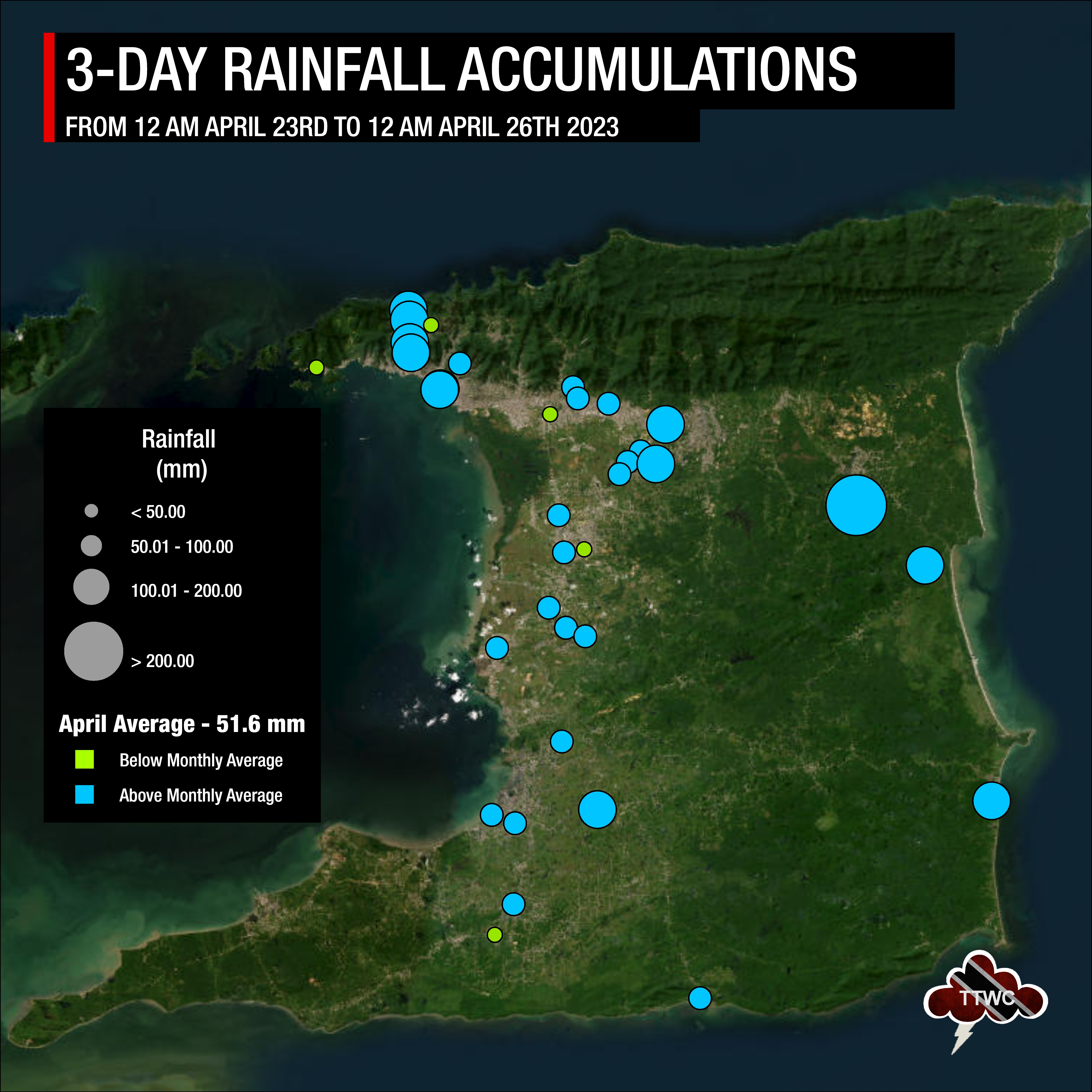
Generally, over the last three days, rain, showers, and thunderstorms have been fairly distributed, with most areas recording upwards of 50 millimeters. After Tuesday’s deluge, the eastern and northern halves of Trinidad have generally recorded more rain than the remainder of the country.
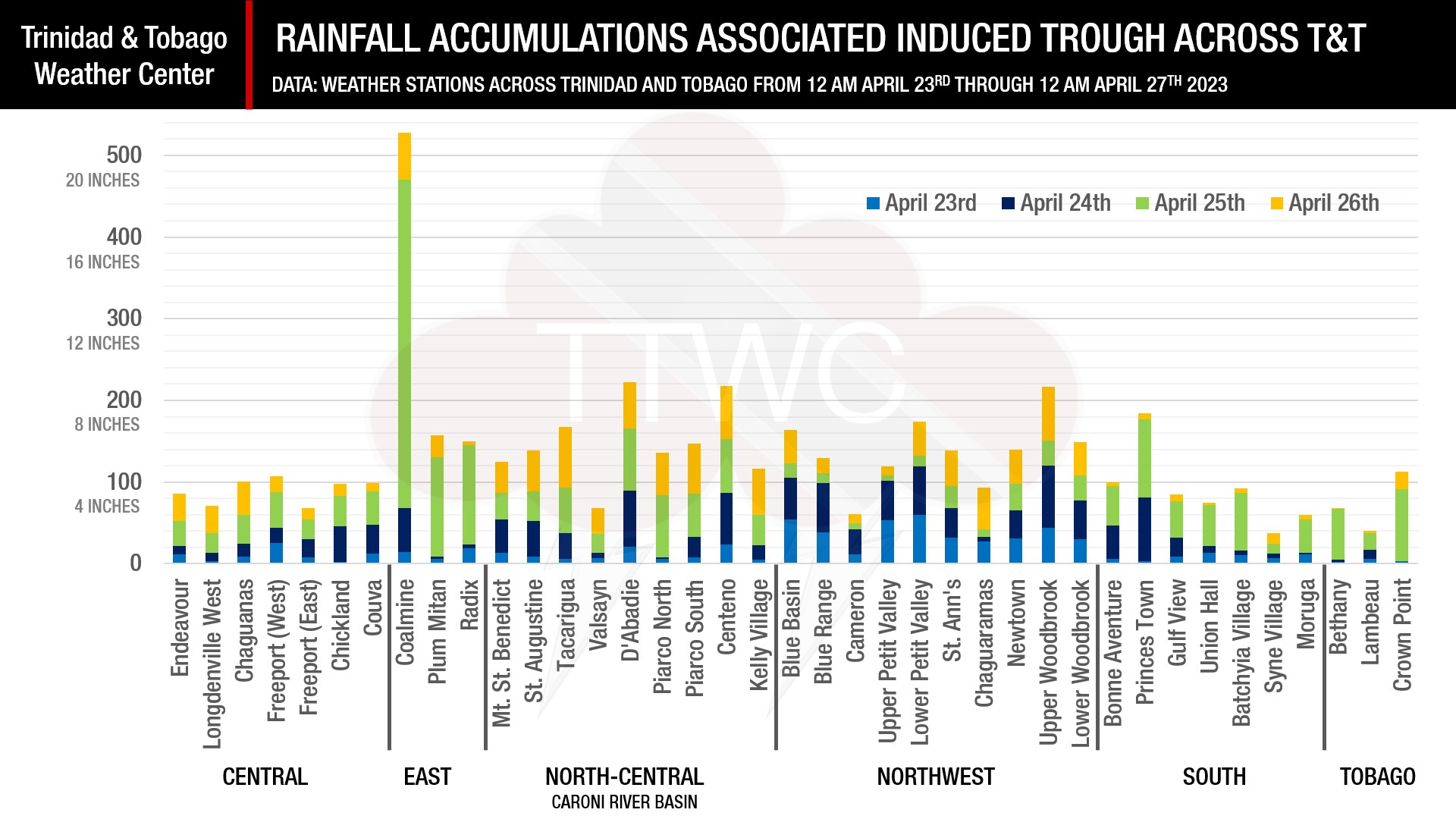
Update: On Wednesday, the country received another round of heavy showers and isolated thunderstorms, with the northern half of Trinidad receiving the brunt of the rainfall. Between 30 and 75 millimeters were recorded from as far west as Chagauaramas to as far east as Coalmine. Further south, less than 15 millimeters were recorded. However, a significant amount of rain fell within the Caroni River Basin catchment area on Wednesday, with rainfall totals between 40 and 75 millimeters, most of which fell on saturated soils.
Trinidad and Tobago’s reservoirs have slightly improved as a result, with the latest data from the Water and Sewerage Authority showing an increase in water levels at the Hollis, now at 47.74%, though it remains below the long-term average of 54.84%. All other reservoirs have decreased from last week’s reservoir levels, but the Caroni and Hillsborough reservoirs remain above long-term averages.
For April, the third driest month for the year in Trinidad and the second driest month for the year in Tobago, a heavy rainfall event like this is not the norm. However, it is far from unprecedented. This is the second consecutive year Trinidad and Tobago has been placed under an Adverse Weather Alert in April and the third consecutive year April has recorded thunderstorms across T&T. Although April is generally dry, on April 22nd, 1973, Piarco recorded 104.9 millimeters of rainfall within an hour, the highest one-hour rainfall total for April.
Extreme rainfall – a consequence of climate change
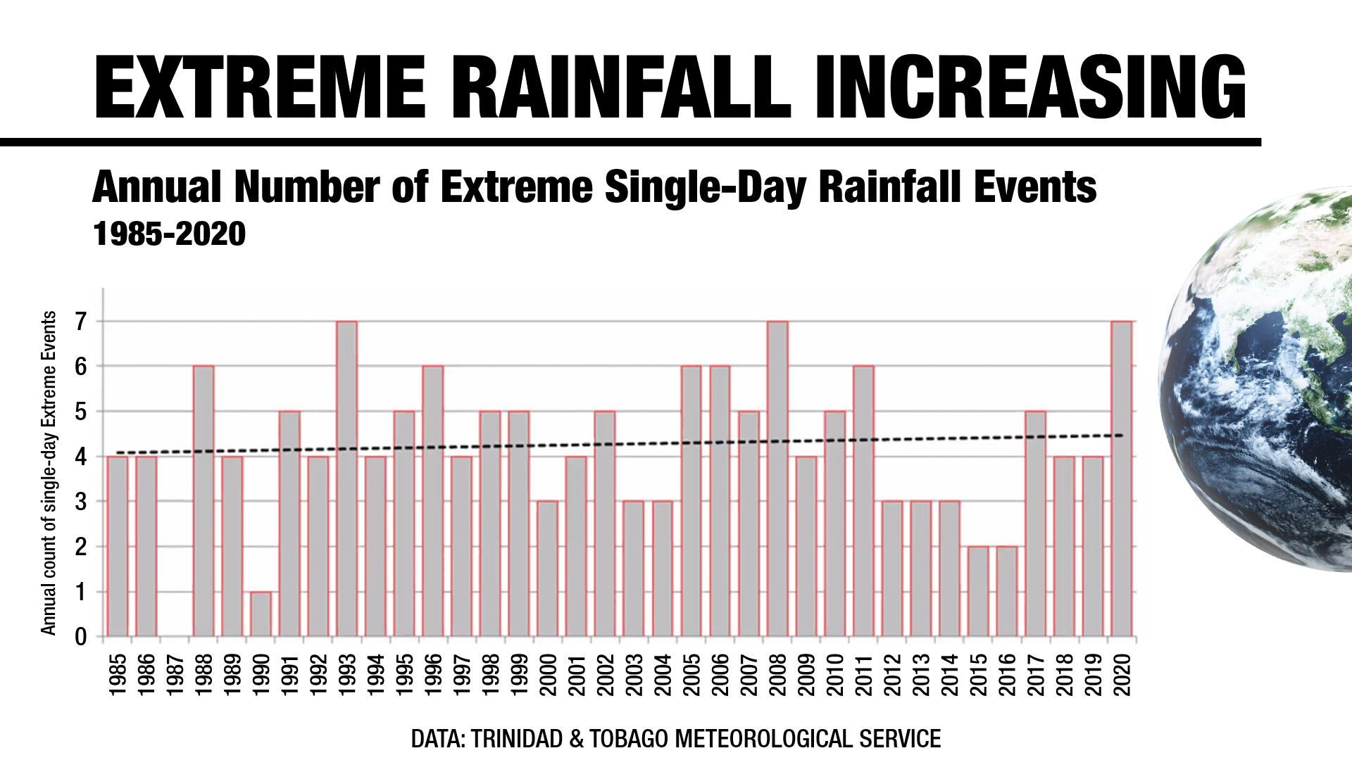
Trinidad and Tobago, according to data from the TTMS, has been warming nearly two and a half times faster than the global average. Warmer air can hold more moisture, which in turn, causes heavier rainfall. Since 1985, The Met Office has recorded an increase in the number of extreme single-day rainfall events, extreme three-day rainfall, and an increase in the percentage of rain these extremely wet days contribute to our annual rainfall totals.
