


For the third consecutive year, Trinidad and Tobago has been placed under an Adverse Weather Alert during April, one of the drier months of the Dry Season. This latest alert comes as Trinidad and Tobago experiences its third day of flooding rainfall, with nearly 400 millimeters (and counting!) of rain accumulating in northeastern Trinidad since 12:00 AM Tuesday.
What you need to know
— Rainfall: Through the next 36 hours, periods of rain with isolated moderate to heavy showers and thunderstorms forecast, with higher totals favoring eastern Trinidad, and interrupting cloudy skies. Additional rainfall totals between 25 and 50 millimeters are forecast across both islands over the next 48 hours, with locally higher amounts exceeding 50 millimeters.
— Hazards: Street and flash flooding have been observed across Trinidad, with riverine flooding very likely across northeastern Trinidad. Wind gusts in excess of 45 KM/H accompanying heavy showers or thunderstorms are likely, with gusts in excess of 55 KM/H possible during and ahead of heavy showers or thunderstorms. Localized wind damage, such as fallen trees, is possible. Lightning will accompany thunderstorms. Landslides are also possible, mainly across northeastern Trinidad. Seas are forecast to become locally agitated during heavy showers or thunderstorms.
Latest Alerts

Adverse Weather Alert Discontinued, Moderate Impacts Still Possible
Trinidad and Tobago is NOT under any tropical storm or hurricane threat, watch, or warning at this time.
The Adverse Weather Alert
The Trinidad and Tobago Meteorological Service issued an Adverse Weather Alert (Yellow Level) on Tuesday at 8:31 AM. The alert went into effect for Trinidad, Tobago, and surrounding marine areas from 8:30 AM Tuesday, April 25th, 2023 and remains in effect through 10:00 AM Wednesday, April 26th, 2023. Severe weather on Tuesday has been ongoing since 3:00 AM.
Trinidad and Tobago is not under any tropical storm watch or warning at this time.
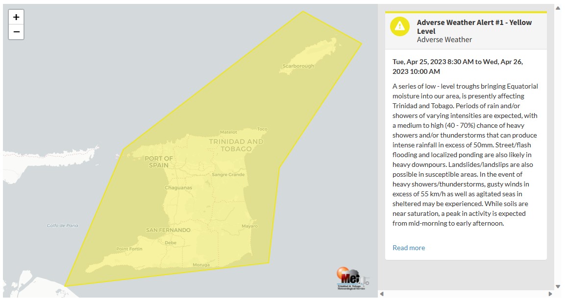
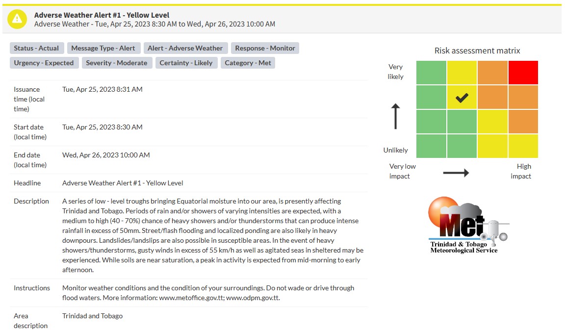
“A series of low-level troughs bringing Equatorial moisture into our area is presently affecting Trinidad and Tobago. While soils are near saturation, a peak in activity is expected from mid-morning to early afternoon,” according to the Met Office.
This “alert” status takes into account the possibility of the event occurring. This adverse weather event is likely with the following impacts, according to the TTMS:
- Periods of rain and/or showers of varying intensities are expected, with a medium to high (40 – 70%) chance of heavy showers and/or thunderstorms that can produce intense rainfall in excess of 50mm.
- Street/flash flooding and localized ponding are also likely in heavy downpours.
- Landslides/landslips are also possible in susceptible areas.
- In the event of heavy showers/thunderstorms, gusty winds in excess of 55 km/h as well as agitated seas in sheltered may be experienced.

The color of the alert indicates the severity of the event and the probability of the event occurring. Currently, the alert level is Yellow. This means that the hazards are likely, and the severity of the impacts is moderate for this particular alert. You should be aware of the hazards in your area associated mainly with gusty winds in excess of 55 KM/H, street, flash, and riverine flooding, landslides, as well as frequent lightning.
For a moderate Adverse Weather Alert, there is the potential for possible injuries, where behavioral changes are required to ensure safety. There may be minor damage to property, with income-earning temporarily disrupted and a couple of communities affected.
The Met Office is advising the public to monitor weather conditions and updates from official sources and not wade or drive through flood waters.


