For the first time in several weeks, mostly sunny skies are forecast to persist across the country over the next five days, leading to higher daytime maximum highs and cooler nighttime temperatures.
It is important to note that high maximum daytime temperatures are typical during October, which marks the secondary peak of the local heat season in Trinidad and Tobago.
The Forecast
Monday
Low: 23-24°C
High: 32-34.5°C
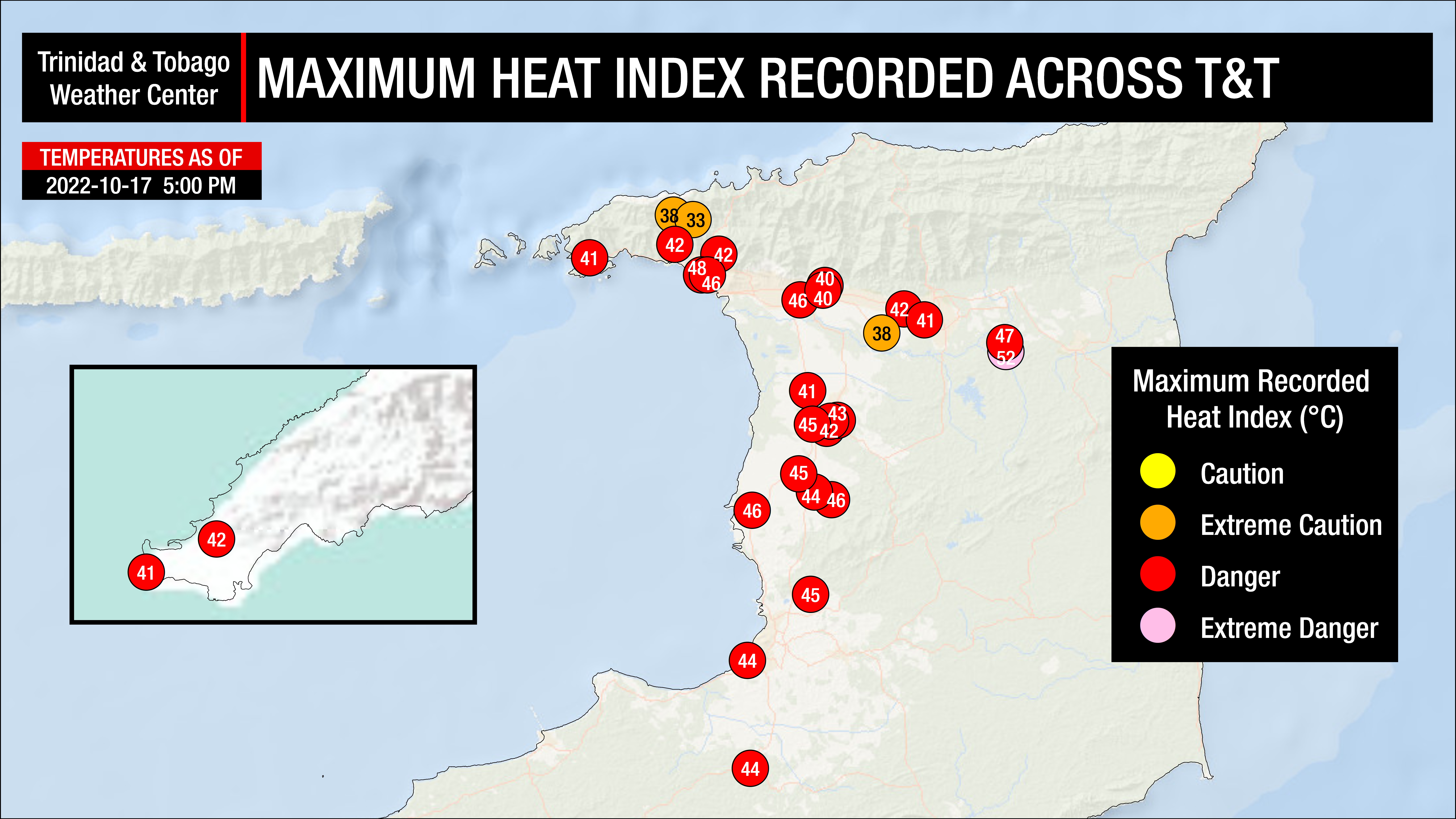
A maximum high of 32.0°C is forecast across Tobago, while temperatures are forecast to reach 34.5°C in Trinidad, with hotter temperatures across urbanized areas. Heat indices (or feels-like temperatures) are forecast to be between 35°C and 48°C. Locally higher heat indices are possible in urbanized areas like Port of Spain, Chaguanas, and San Fernando.
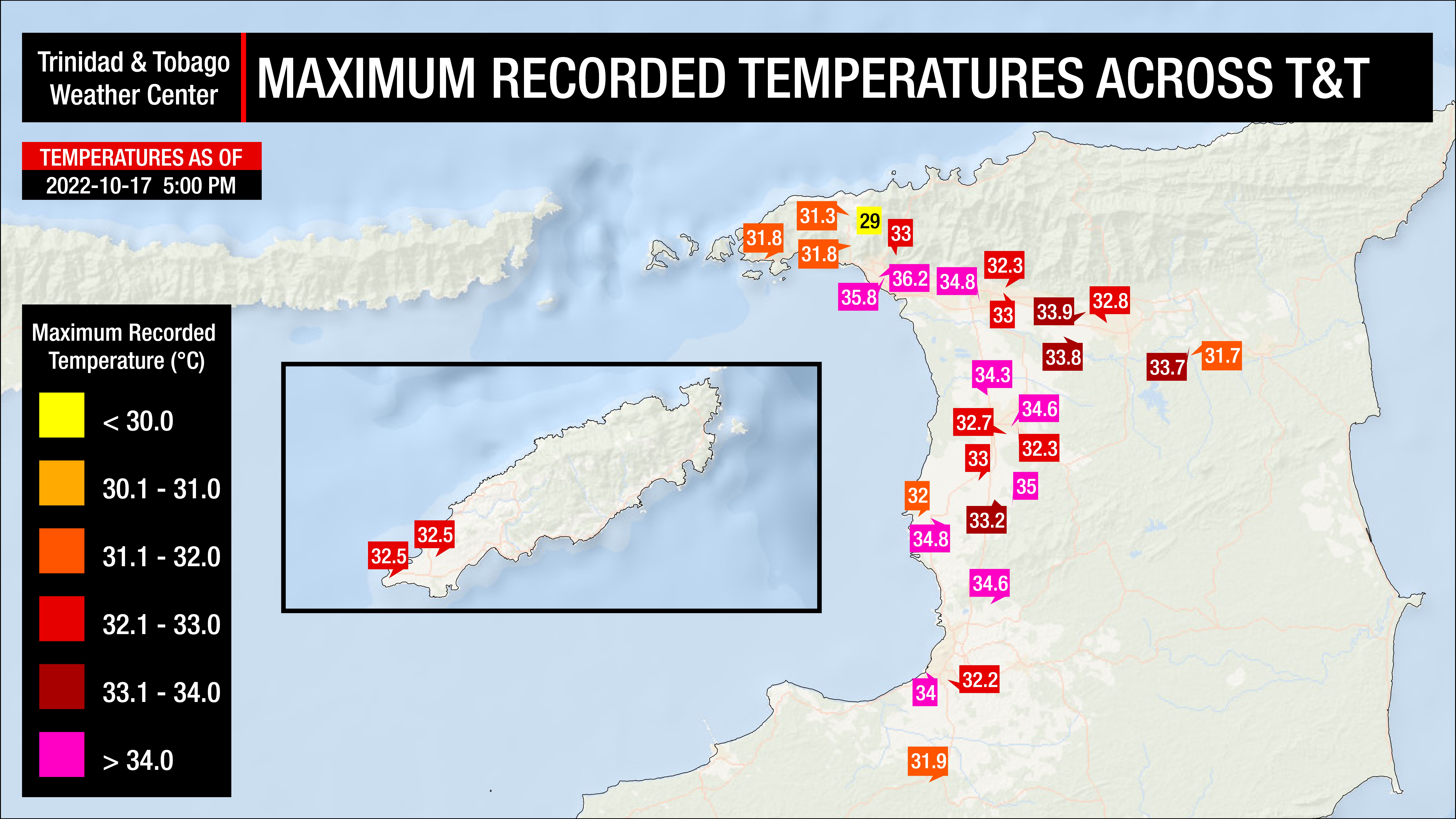
Monday’s Recorded Temperatures & Heat Indicies
Tuesday
Low: 23-24°C
High: 32-35°C
A maximum high of 32.0°C is forecast across Tobago, while temperatures are forecast to reach 35°C in Trinidad, with hotter temperatures across urbanized areas. Heat indices (or feels-like temperatures) are forecast to be between 35°C and 48°C. Locally higher heat indices are possible in urbanized areas like Port of Spain, Chaguanas, and San Fernando.
Wednesday
Low: 23-24°C
High: 32-34°C
A maximum high of 32.0°C is forecast across Tobago, while temperatures are forecast to reach 34°C in Trinidad, with hotter temperatures across urbanized areas. Heat indices (or feels-like temperatures) are forecast to be between 35°C and 48°C. Locally higher heat indices are possible in urbanized areas like Port of Spain, Chaguanas, and San Fernando.
Thursday
Low: 23-24°C
High: 32-35°C
A maximum high of 32.0°C is forecast across Tobago, while temperatures are forecast to reach 35°C in Trinidad, with hotter temperatures across urbanized areas. Heat indices (or feels-like temperatures) are forecast to be between 35°C and 48°C. Locally higher heat indices are possible in urbanized areas like Port of Spain, Chaguanas, and San Fernando.
Friday
Low: 23-24°C
High: 32-34°C
A maximum high of 32.0°C is forecast across Tobago, while temperatures are forecast to reach 34°C in Trinidad, with hotter temperatures across urbanized areas. Heat indices (or feels-like temperatures) are forecast to be between 35°C and 48°C. Locally higher heat indices are possible in urbanized areas like Port of Spain, Chaguanas, and San Fernando.
Feeling Hotter Than What’s On The Thermometer?
Many this week will complain about the oppressive heat, with some looking at the 32.0°C to 35.0°C recorded on thermometers and expressing it felt hotter than that.
What the outside feels like is called the heat index. It is a combination of air temperature (what’s recorded on the thermometer) and relative humidity, determining what the air feels like to a person, i.e., how hot it actually feels.
The heat index is important because of sweating. Your body sweats to cool the skin and maintain a constant, healthy body temperature. This cooling process means the sweat has to evaporate off the skin to remove heat. However, if the sweat is unable to evaporate, the body isn’t able to regulate temperature.
With high volumes of moisture in the air, also known as high relative humidity, which T&T regularly experiences due to its tropical climate, the rate of sweat evaporation decreased. This is because the atmosphere is unable or has limited potential to hold additional moisture.
As temperature increases, the heat index increases. As relative humidity increases, so does the heat index. This results in you feeling warmer in humid conditions and cooler in less humid conditions when relative humidity decreases.
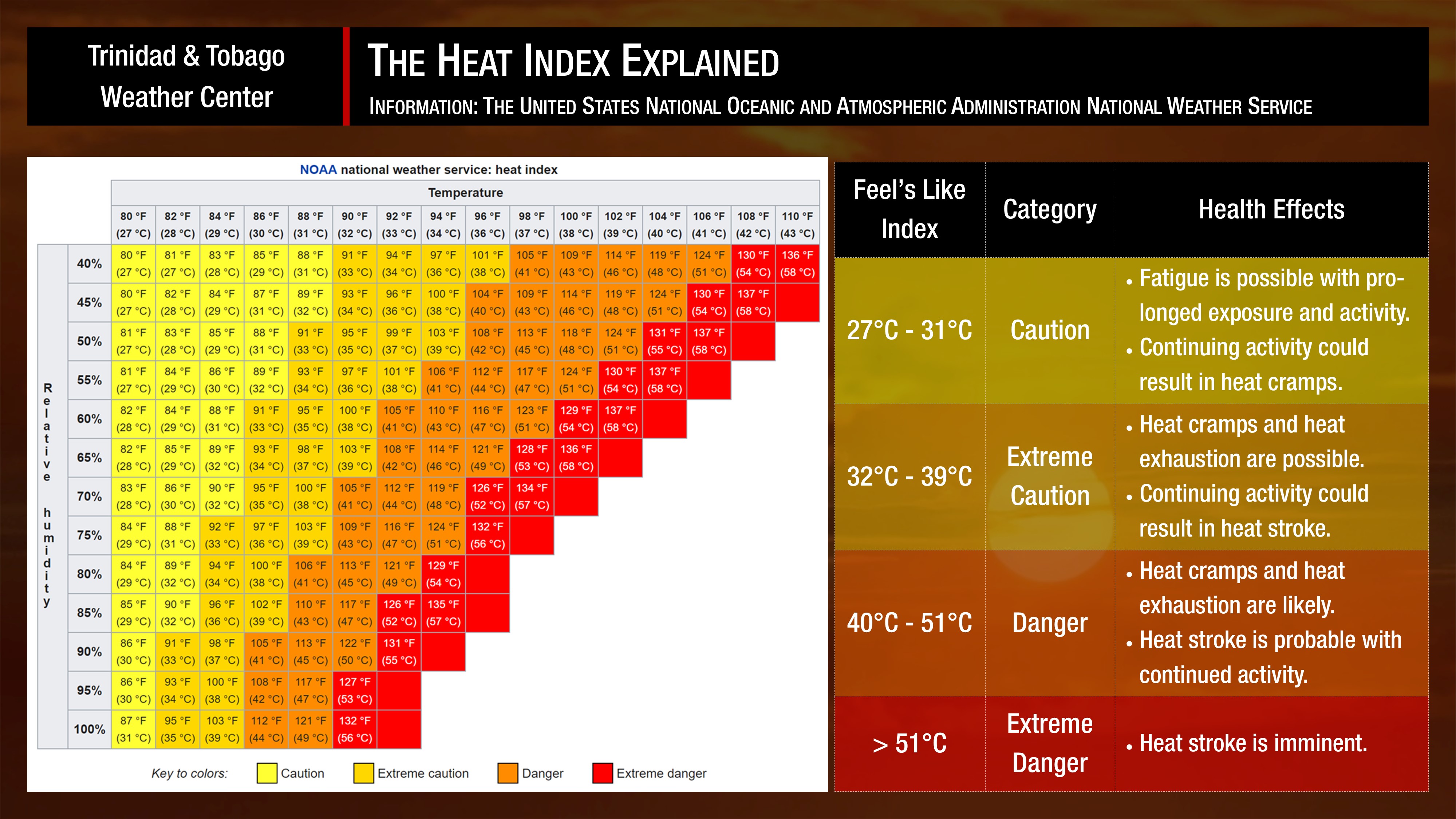
The heat index is generally classified into four categories: caution, extreme caution, dangerous, and extremely dangerous. Generally, heat indices may reach dangerous levels across Trinidad and Tobago this week.
Temperatures in cities, such as Port of Spain, tend to be much higher than surrounding locations due to a phenomenon called the Urban Heat Island Effect. There are several causes, but the main instigator for this phenomenon tends to be increased dark surfaces, such as roads and pavement in cities, which absorb solar radiation more than surrounding areas.
What’s causing the higher temperatures?

Over the next five days, a weak surface to low-level high-pressure ridge is forecast to remain dominant across Trinidad, Tobago, and much of the Windward Islands. Areas of high-pressure produce sinking air, effectively keeping a pocket of air, in the case at the surface, to the low levels of the atmosphere, in one place.
During the day, when the air is heated, the air generally rises. When high-pressure systems are in place, that rising hot air has nowhere to go, leading to increasingly hotter temperatures.
However, this is also the time of the year when tropical waves trail across the Lesser Antilles. The current trio of waves are fairly devoid of convection (showers/thunderstorms) due to strong wind shear associated with a well-established mid- to upper-level trough moving eastward. This upper-level trough has also slowed the forward speed of these tropical waves and weakened the pressure gradient across the Lesser Antilles.
The combination of this high-pressure ridge, albeit weak, gentle to near calm low-level winds, and a fairly dry atmosphere will lead to higher maximum daytime temperatures this week. However, this strong daytime heating will also lead to isolated afternoon showers developing along western and hilly areas of Trinidad, which may also bring needed heat relief this week.
Will this be a heatwave?
For a hot spell (or heatwave) to be declared in Trinidad and Tobago by the Trinidad and Tobago Meteorological Service, a period of hot temperatures, characterized by maximum temperatures of at least 34.0°C in Trinidad and 32.0°C in Tobago, lasting five or more consecutive days. A short-duration hot spell (or heatwave) is three or more consecutive hot days.
Based on the current forecast temperatures, this criteria could be met, but with the potential for afternoon showers and isolated thunderstorms daily, maximum high temperatures could fall just shy of hitting the required threshold.
According to the Trinidad and Tobago Meteorological Service, the hottest temperature recorded in October was on October 17th and 19th of 2016, where maximum highs at Piarco came in at 36.2°C. Trinidad’s hottest temperature at Piarco was 36.5°C, recorded on September 25th, 1990.
What should you do?
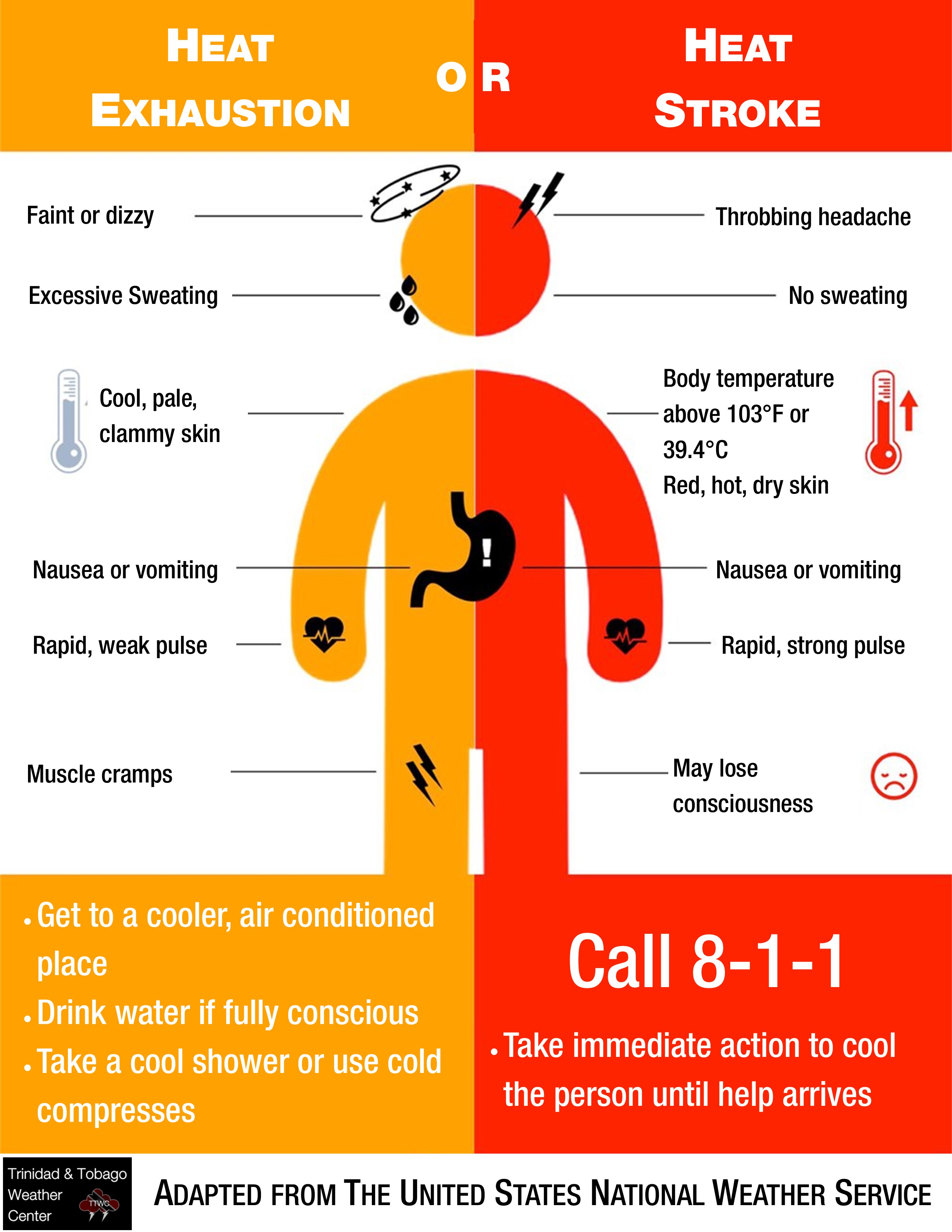
Know the symptoms of heat exhaustion and heat stroke.
Don’t leave children or pets in a locked car.


Monitor vulnerable groups
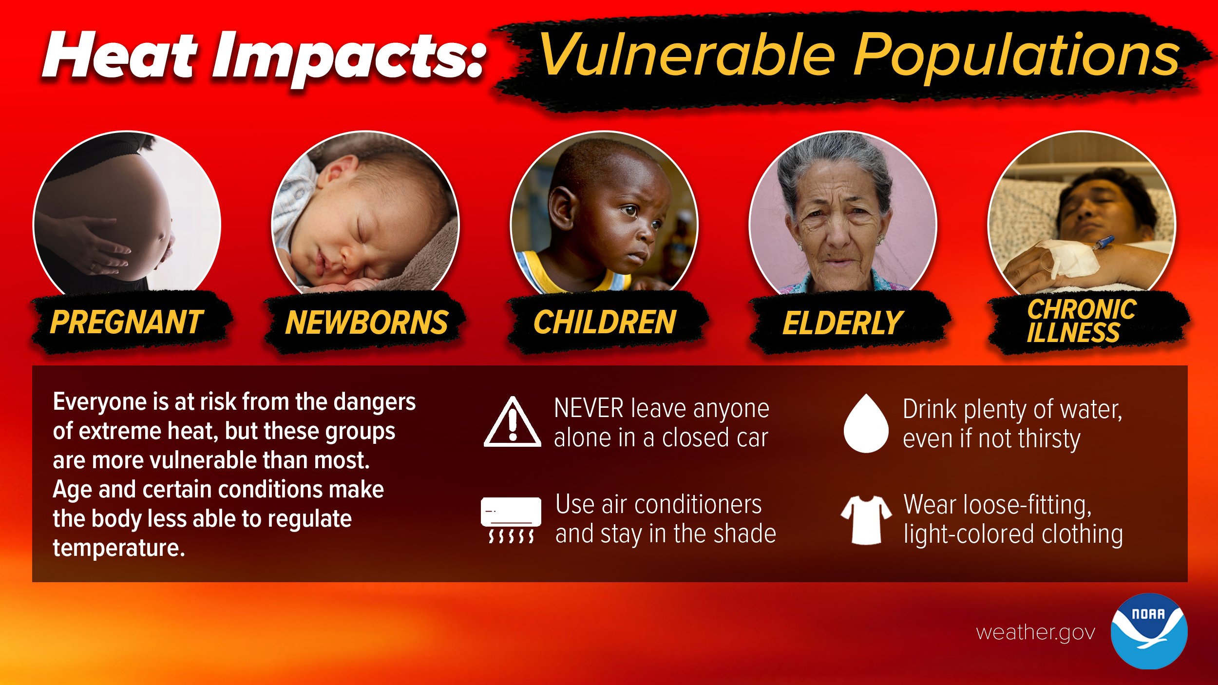
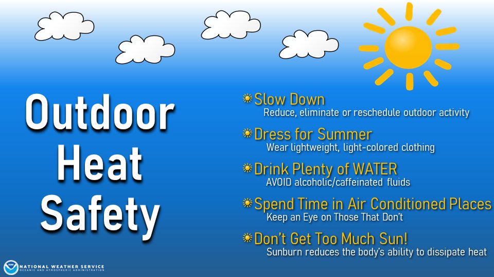
General Heat Safety Tips