


Though the worst has passed, isolated heavy showers and thunderstorms are forecast for Trinidad and Tobago through Friday. This activity is due to trailing moisture and instability following Invest 91L, a tropical disturbance attached to Tropical Wave 41 that is being monitored for tropical cyclone development and now the Intertropical Convergence Zone across the country.
What you need to know
— Rainfall: Through Friday, isolated moderate to heavy showers and isolated thunderstorms are forecast, interrupting variably cloudy skies. Peak intense activity, including isolated heavy to violent showers and intense thunderstorms, is forecast from the late morning through Thursday afternoon and then again from the late morning on Friday into the afternoon. Additional rainfall totals between 25 and 75 millimeters are forecast across both islands over the next 72 hours with locally higher amounts.
— Hazards: Street, flash, and riverine flooding with localized ponding are expected. Wind gusts in excess of 55 KM/H accompanying heavy showers or thunderstorms are likely, with wind gusts in excess of 45 KM/H expected. Lightning will accompany thunderstorms. Landslides are likely across both islands.
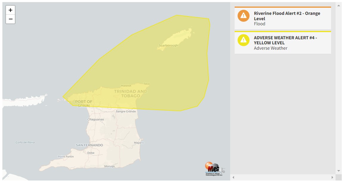
— Alerts/Watches/Warnings: The Trinidad and Tobago Meteorological Service updated the Adverse Weather Alert (Yellow Level) for now Northern Trinidad and Tobago from 12:00 AM Wednesday, October 5th, 2022, and remains in effect through 12:00 PM Friday, October 7th, 2022. A Riverine Flood Alert (Orange Level) also went into effect for Trinidad and Western Tobago from 5:03 PM Wednesday, October 5th, 2022, and remains in effect through 5:00 PM Friday, October 7th, 2022. There are no tropical storm or hurricane watches or warnings in effect for T&T at this time.
The Adverse Weather Alert
The Trinidad and Tobago Meteorological Service updated the Adverse Weather Alert (Yellow Level) on Thursday at 2:34 PM. The alert went into effect for Trinidad and Tobago from midnight 12:00 AM Wednesday, October 5th, 2022, and remains in effect through 12:00 PM Friday, October 7th, 2022.
Trinidad and Tobago is not under any tropical storm watch or warning at this time.
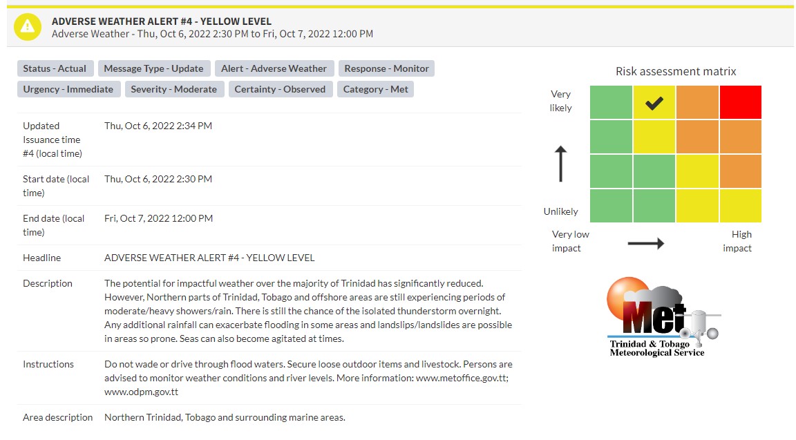
“The potential for impactful weather over the majority of Trinidad has significantly reduced. However, the Northern parts of Trinidad, Tobago, and offshore areas are still experiencing periods of moderate/heavy showers/rain. There is still the chance of an isolated thunderstorm overnight. Any additional rainfall can exacerbate flooding in some areas, and landslips/landslides are possible in areas so prone. Seas can also become agitated at times,” according to the Trinidad and Tobago Meteorological Service. This “alert” status takes into account the possibility of the event occurring. This adverse weather event has been observed.

The color of the alert indicates the severity of the event and the probability of the event occurring. Currently, the alert level is Yellow. This means that the hazards have been observed, and the severity of the impacts is moderate for this particular alert. You should be aware of the hazards in your area associated mainly with gusty winds in excess of 55 KM/H, street, flash, and riverine flooding, landslides, as well as frequent lightning.
For a moderate Adverse Weather Alert, there is the potential for possible injuries, where behavioral changes are required to ensure safety. There may be minor damage to property, with income-earning temporarily disrupted and a couple of communities affected.
The Met Office is advising the public to monitor weather conditions and updates from official sources, do not wade or drive through flood waters and secure loose outdoor items and livestock.


