


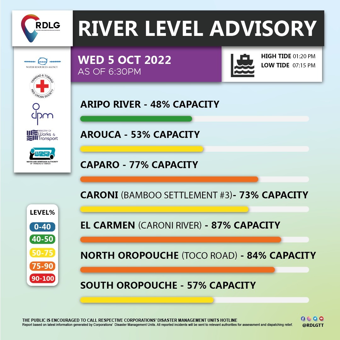
Invest 91L dumped just under half an average month’s worth of rainfall (for the month of October), and major rivers across Trinidad continue to rise. Water levels of the Caroni and North Oropouche Rivers are nearing 80% capacity as of 5:00 PM, with other major rivers elevated.
6:30 PM Update: River levels continue to rise across Trinidad as trailing showers and thunderstorms persist across the country. The Caroni River has reached 87% capacity at El Carmen, while the North Oropouche River is at 84% capacity.
With additional rainfall on the horizon, the Trinidad and Tobago Meteorological Service issued a Riverine Flood Alert for all of Trinidad and even parts of Tobago. For the second time since the Early Warning System was implemented, the Riverine Flood Alert is also in effect for parts of Western Tobago for the Darrell Spring River and Crooks River. Tobago was placed under a Riverine Flood Alert for the first time just over one week ago.
What you need to know
— What has happened: Over the last 18 hours, between 50 and 125 millimeters of rain fell across parts of Trinidad and Tobago associated with the passage of Invest 91L, a tropical disturbance attached to Tropical Wave 41. Additional rainfall accumulations between 25 and 50 millimeters are forecast through the next 48 hours with locally higher totals.
— What to expect: Riverine flooding is likely on Thursday, mainly for smaller watercourses that feed into major rivers across the country. Runoff will be slowed by spring tides which are forecast to begin on Thursday, October 6th, 2022.
— Alerts/Watches/Warnings: A Riverine Flood Alert (Yellow Level) went into effect for Trinidad and Western Tobago from 5:03 PM Wednesday, October 5th, 2022, and remains in effect through 5:00 PM Friday, October 7th, 2022. The Met Office also has Trinidad and Tobago under an Adverse Weather Alert (Yellow Level) until 12:00 PM Friday, October 7th, 2022. There are no tropical storm or hurricane watches or warnings in effect for T&T at this time.
The Riverine Flood Alert
The Trinidad and Tobago Meteorological Service issued a Riverine Flood Alert (Yellow Level) on Wednesday at 5:03 PM. The alert went into effect for Trinidad and parts of Western Tobago inclusive of the Crooks and Darrell Spring Rivers from 5:03 PM Wednesday, October 5th, 2022, and remains in effect through 5:00 PM Friday, October 7th, 2022
This alert for Tobago is unusual, as the island generally experiences flash flooding, where flood waters associated with rivers overtopping subside fairly quickly after rainfall ceases. Riverine flooding, on the other hand, occurs, when flooding persists for several hours or days, even after rainfall ceases.
Trinidad and Tobago is not under any tropical storm watch or warning at this time.
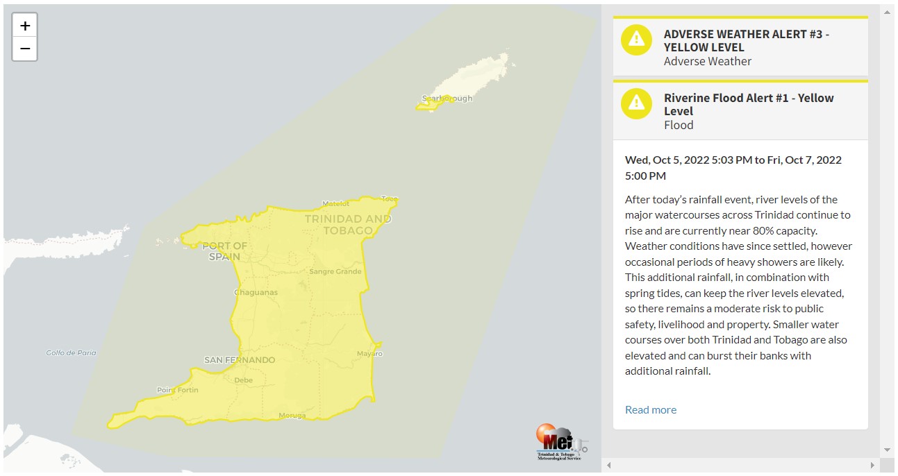
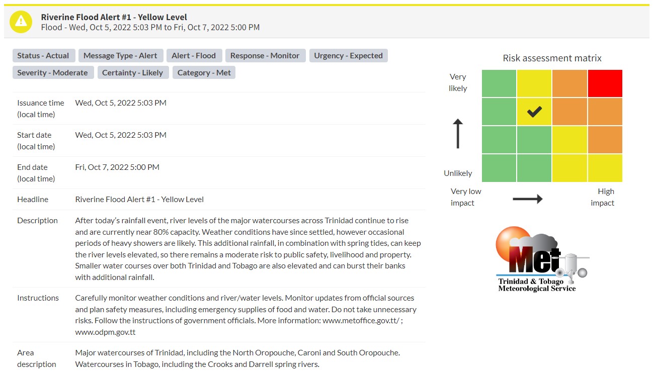
“After today’s rainfall event, river levels of the major watercourses across Trinidad continue to rise and are currently near 80% capacity. Weather conditions have since settled, however occasional periods of heavy showers are likely. This additional rainfall, in combination with spring tides, can keep the river levels elevated, so there remains a moderate risk to public safety, livelihood and property. Smaller water courses over both Trinidad and Tobago are also elevated and can burst their banks with additional rainfall,” according to the Trinidad and Tobago Meteorological Service. This “alert” status takes into account the possibility of the event occurring. This riverine flood event is likely.

The color of the alert indicates the severity of the event and the probability of the event occurring. Currently, the alert level is Yellow. This means that the hazard has been observed, and you need to be aware of the impacts of street, flash, and riverine flooding in your area. Moderate impacts are likely.
For a moderate Riverine Flood Alert, there is the potential for possible injuries, with behavioral changes required to ensure safety. There may be minor damage to property, with income-earning temporarily disrupted. A couple of communities are affected.
Carefully monitor weather conditions and river/water levels. Monitor updates from official sources and plan safety measures, including emergency supplies of food and water, and do not take unnecessary risks. Avoid driving or wading through floodwaters. Follow the instructions of government officials.


