


The South Oropouche River is at 91% capacity as of 12:00 PM (noon) Monday, according to the Ministry of Rural Development and Local Government, prompting the Trinidad and Tobago Meteorological Service to issue a Riverine Flood Alert for the South Oropouche River Basin. For the first time since the Early Warning System was implemented, the Alert is also in effect for parts of Western Tobago for the Bacolet and Crooks River. Other rivers remain closely monitored but within their banks. Riverine flooding is ongoing across parts of Woodland, Barrackpore, and surrounding low-lying areas.
What you need to know
— What has happened: Over the last 24-36 hours, up to 50 millimeters of rain fell across parts of Trinidad and Tobago associated with a deep-layered trough system and the Intertropical Convergence Zone. Additional rainfall accumulations between 25 and 50 millimeters are forecast through the next 48 hours with locally higher totals. Major rivers across Trinidad remain well within their banks but the South Oropouche River and its tributaries have already begun to overtop, leading to flooding in Woodland, Penal, and Barrackpore.
— What to expect: Riverine flooding is expected to continue through the next 24 hours across the South Oropouche River Basin, exacerbated by spring tides are forecast to end by Wednesday, September 28th, 2022.
— Alerts/Watches/Warnings: A Riverine Flood Alert (Yellow Level) went into effect for the South Oropouche River Basin and Western Tobago from 10:00 AM Monday, September 26th, 2022, and remains in effect through 12:00 AM (midnight) Wednesday, September 28th, 2022, from the Trinidad and Tobago Meteorological Service. There are no tropical storm or hurricane watches or warnings in effect for T&T at this time.
The Riverine Flood Alert
The Trinidad and Tobago Meteorological Service issued a Riverine Flood Alert (Yellow Level) on Monday at 9:51 AM. The alert went into effect for the South Oropouche River Basin and parts of Western Tobago near the Crooks and Bacolet Rivers from 10:00 AM Monday, September 26th, 2022, and remains in effect through 12:00 AM (midnight) Wednesday, September 28th, 2022.
This alert for Tobago is highly unusual, as the island generally experiences flash flooding, where flood waters associated with rivers overtopping subside fairly quickly after rainfall ceases. Riverine flooding, on the other hand, occurs, when flooding persists for several hours or days, even after rainfall ceases.
Trinidad and Tobago is not under any tropical storm watch or warning at this time.
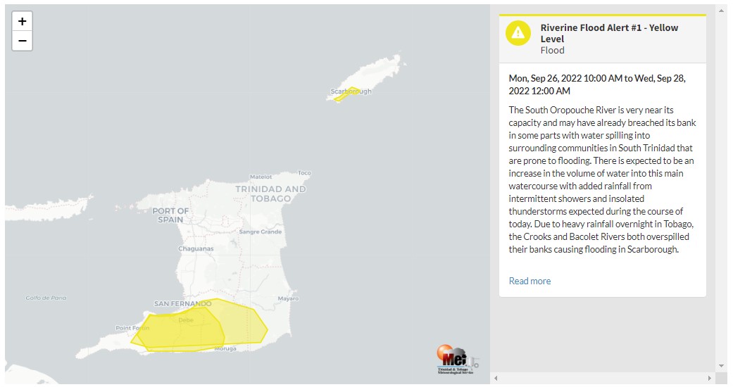
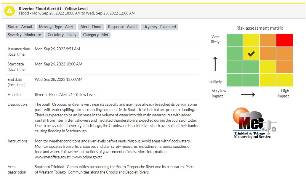
“The South Oropouche River is very near its capacity and may have already breached its bank in some parts with water spilling into surrounding communities in South Trinidad that are prone to flooding. There is expected to be an increase in the volume of water into this main watercourse with added rainfall from intermittent showers and insolated thunderstorms expected during the course of today. Due to heavy rainfall overnight in Tobago, the Crooks and Bacolet Rivers both overspilled their banks causing flooding in Scarborough,” according to the Trinidad and Tobago Meteorological Service. This “alert” status takes into account the possibility of the event occurring. This riverine flood event is likely.

The color of the alert indicates the severity of the event and the probability of the event occurring. Currently, the alert level is Yellow. This means that the hazard has been observed, and you need to be aware of the impacts of street, flash, and riverine flooding in your area. Moderate impacts are likely.
For a moderate Riverine Flood Alert, there is the potential for possible injuries, with behavioral changes required to ensure safety. There may be minor damage to property, with income-earning temporarily disrupted. A couple of communities are affected.
Carefully monitor weather conditions and river/water levels. Monitor updates from official sources and plan safety measures, including emergency supplies of food and water, and do not take unnecessary risks. Avoid driving or wading through floodwaters. Follow the instructions of government officials.


