


Heavy showers and thunderstorms are forecast for Trinidad and Tobago over the weekend, associated with an active Intertropical Convergence Zone (ITCZ), a tropical wave, and a surface to a low-level trough extending from another tropical wave later this weekend.
What you need to know
— Rainfall: Through the next 48 hours, areas of rain, moderate to heavy showers, and isolated to scattered thunderstorms are forecast, interrupting variably cloudy skies. Peak intense activity, including isolated heavy to violent showers and intense thunderstorms, is forecast from the early morning through the afternoon, gradually settling by the evening on both days. Notably, activity is set to move from the south to the north, intensifying along the south-facing slopes of the Northern Range and along western coastal Trinidad. Overall rainfall totals between 25 and 50 millimeters are forecast across both islands. Isolated totals may accumulate up to 125 millimeters across Central and Northern Trinidad.
— Hazards: Chances for street/flash flooding are high over the weekend. Chances for riverine flooding remain low at this time. Gusty winds in excess of 45 KM/H accompanying heavy showers or thunderstorms are likely, with wind gusts in excess of 55 KM/H possible in highly localized areas. Lightning will accompany thunderstorms. Landslides are possible across northern areas of Trinidad and Tobago.
— Alerts/Watches/Warnings: An Adverse Weather Alert (Yellow Level) goes into effect for northern Trinidad and Tobago from 5:00 AM Saturday, August 13th, 2022, and remains in effect through 6:00 PM Sunday, August 14th, 2022, from the Trinidad and Tobago Meteorological Service. There are no tropical storm or hurricane watches or warnings in effect for T&T at this time.
The Adverse Weather Alert
The Trinidad and Tobago Meteorological Service issued an Adverse Weather Alert (Yellow Level) on Friday at 4:05 PM. The alert goes into effect for northern Trinidad and Tobago from 5:00 AM Saturday, August 13th, 2022, and remains in effect through 6:00 PM Sunday, August 14th, 2022. While northern Trinidad and Tobago is under the alert, showers and thunderstorms are also forecast across central and southern Trinidad through the weekend, with the most intense activity along western coastal and northern Trinidad, as well as Tobago.
Trinidad and Tobago is not under any tropical storm watch or warning at this time.
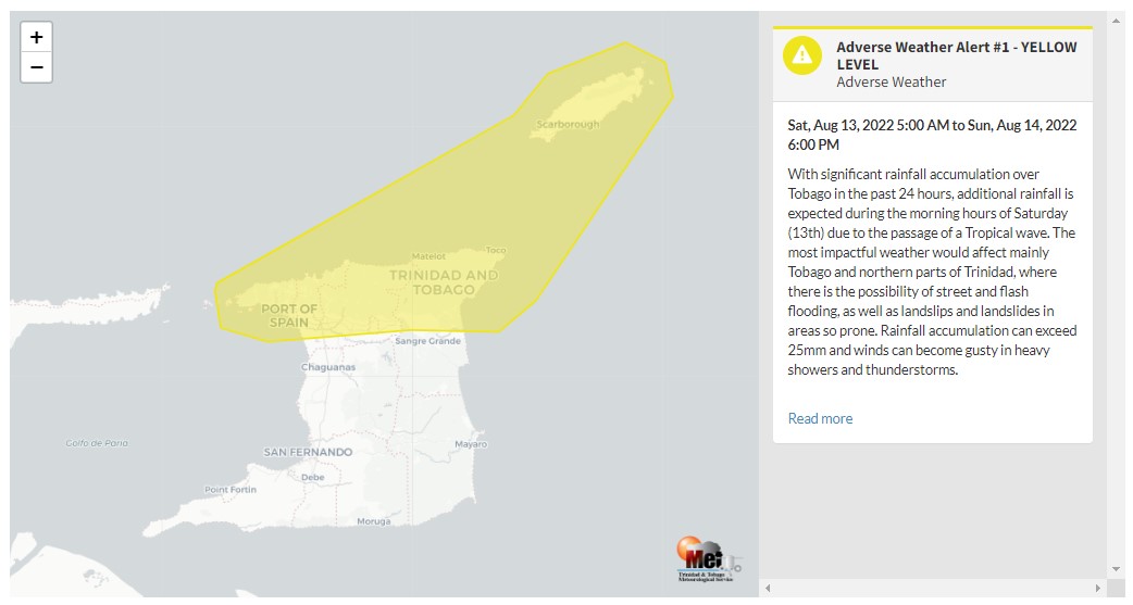
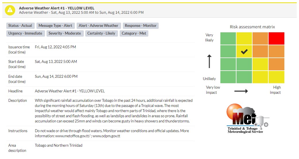
“With significant rainfall accumulation over Tobago in the past 24 hours, additional rainfall is expected during the morning hours of Saturday (13th) due to the passage of a Tropical wave. The most impactful weather would affect mainly Tobago and northern parts of Trinidad, where there is the possibility of street and flash flooding, as well as landslips and landslides in areas so prone. Rainfall accumulation can exceed 25mm, and winds can become gusty in heavy showers and thunderstorms.” according to the Trinidad and Tobago Meteorological Service. This “alert” status takes into account the possibility of the event occurring. This adverse weather event is likely.

The color of the alert indicates the severity of the event and the probability of the event occurring. Currently, the alert level is Yellow. This means that the hazards are likely, but the severity of impacts is moderate for this particular alert. You should be aware of the hazards in your area associated mainly with gusty winds in excess of 55 KM/H, street and flash flooding, as well as frequent lightning.
For a moderate Adverse Weather Alert, there is the potential for possible injuries, where behavioral changes are required to ensure safety. There may be minor damage to property, with income-earning temporarily disrupted and a couple of communities affected.
The Met Office is advising the public not to venture into floodwaters as well as monitor weather conditions and updates from official sources.


