


Showers and thunderstorms are in Trinidad and Tobago’s forecast through the weekend as multiple weather features come together. By late Sunday, Saharan Dust is forecast to begin reducing rainfall across the area.
What you need to know
— Saharan Dust: A surge of Saharan Dust is set to move across the islands from late Sunday.
— Rainfall: Isolated showers and thunderstorms are forecast mainly through Monday. Over the next five days, overall rainfall totals between 25 and 75 millimeters are forecast across most of the country. However, isolated totals of up to 150 millimeters of rain are possible, with the heaviest rainfall occurring on Saturday and Sunday.
— Hazards: The main hazards are street/flash flooding across central and northern Trinidad, as well as Tobago. Gusty winds up to and over 45 KM/H are likely to accompany heavier showers and thunderstorms, with wind gusts in excess of 55 KM/H possible. The chances for riverine flooding remain low at this time, but rivers across central and northern Trinidad should remain closely monitored by Sunday. Lightning will accompany thunderstorms. Landslides are possible across northern and central areas of Trinidad and in Tobago.
— Alerts/Watches/Warnings: An Adverse Weather Alert (Yellow Level) remains in effect for northern Trinidad and Tobago from 5:00 AM Saturday, August 13th, 2022, and remains in effect through 6:00 PM Sunday, August 14th, 2022, from the Trinidad and Tobago Meteorological Service. There are no tropical storm or hurricane watches or warnings in effect for T&T at this time.
The Forecast
Saturday
SaturdaySunday
SundayMonday
MondayTuesday
TuesdayWednesday
WednesdayMarine: Through Wednesday, seas are forecast to be slight to moderate, with waves in open waters up between 1.0 and 2.0 meters. In sheltered areas, waves are forecast to be near calm but occasionally choppy in the vicinity of heavy showers/thunderstorms.
Temperatures
Through the forecast period, the minimum low in Trinidad and Tobago is forecast to be between 24.0°C and 26.0°C.
Over the next five days, maximum highs across the country are forecast to be up to 32.0°C in Trinidad and 31.0°C in Tobago, with cooler maximum highs on Saturday through Monday across both islands due to increased cloud cover. In urbanized areas like Port of Spain, Scarborough, San Fernando, and Chaguanas, the maximum high temperatures will trend warmer.
Forecast Impacts
Flooding
FloodingThere is a high chance of street and flash flooding, particularly on Saturday through Monday, mainly across central and northern Trinidad, as well as Tobago. Chances for riverine flooding remain low at this time. If high rainfall totals materialize, rivers across central and northern Trinidad will need to be closely monitored.
Forecast Rainfall Totals
- Saturday: Between 10 and 25 millimeters of rainfall across both islands, trending higher across central and northern areas of Trinidad, as well as western coastal Trinidad, and across Tobago. In areas of intense showers or thunderstorms, particularly across Trinidad, isolated 24-hour rainfall accumulations could exceed 75 millimeters.
- Sunday: Between 10 and 15 millimeters of rainfall across both islands, trending higher across central and northern areas of Trinidad, as well as western coastal Trinidad, and across Tobago. In areas of intense showers or thunderstorms, particularly across Trinidad, isolated 24-hour rainfall accumulations could exceed 50 millimeters.
- Monday: Between 10 and 15 millimeters of rainfall across the country, trending higher across southern, eastern, and western coastal Trinidad with isolated totals up to 25 millimeters.
- Tuesday: Less than 10 millimeters across the country, with higher rainfall totals favoring eastern, southern, and western coastal areas of Trinidad.
- Wednesday: Less than 10 millimeters across the country, with higher rainfall totals favoring eastern, southern, and western coastal areas of Trinidad.
Putting the rainfall forecast into context, rainfall rates in excess of 50 millimeters per hour or areas that receive in excess of 25 millimeters within an hour tend to trigger street flooding across the country or flash flooding in northern Trinidad. For riverine flooding to occur, a large area of the country (not just in highly localized areas of western coastal Trinidad) would have to record upwards of 75 millimeters within 24 hours, and rainfall would have to fall across major rivers’ catchment areas.
Strong Thunderstorms
Strong ThunderstormsThe chances of strong thunderstorms are medium to high as a low shear, high moisture, moderate to high instability, and light wind environment is in place through Sunday afternoon. Funnel cloud development is possible through Sunday due to near calm to light and variable winds. The highest chances for funnel cloud/waterspout development exist along western coastal areas of both Trinidad and Tobago, as well as along southern and eastern coastal areas of Trinidad. If a funnel cloud touches down on a body of water, it becomes a waterspout; if it touches down on land, it becomes a tornado.
Abundant frequent cloud-to-ground lightning is possible, accompanying thunderstorms.
Gusty Winds
Gusty WindsWith wind gusts up to and in excess of 55 KM/H, whole trees are expected to be in motion, and there may be some inconvenience when walking against the wind gusts. Light outdoor objects may topple or become airborne such as garbage cans, potted plants, loose galvanize or construction material, and other outdoor furniture. Tents may jump. Older/weaker trees may fall, bringing down utility poles and lines.
Other Hazards
Saharan Dust is forecast to increase across the region by late Sunday into Monday, reducing visibility and air quality.
Why I May Not/Will Not See Rainfall?
A frequent complaint is the forecast is wrong because I didn’t experience any rainfall. Scattered showers mean that you, individually, may experience some showers intermittently throughout the day, and there is a higher chance for this activity than isolated activity. Widespread showers mean that nearly all persons and areas may experience rainfall.
Isolated to scattered showers and thunderstorms on Saturday and Sunday, with highly isolated activity thereafter.

Forecast Discussion
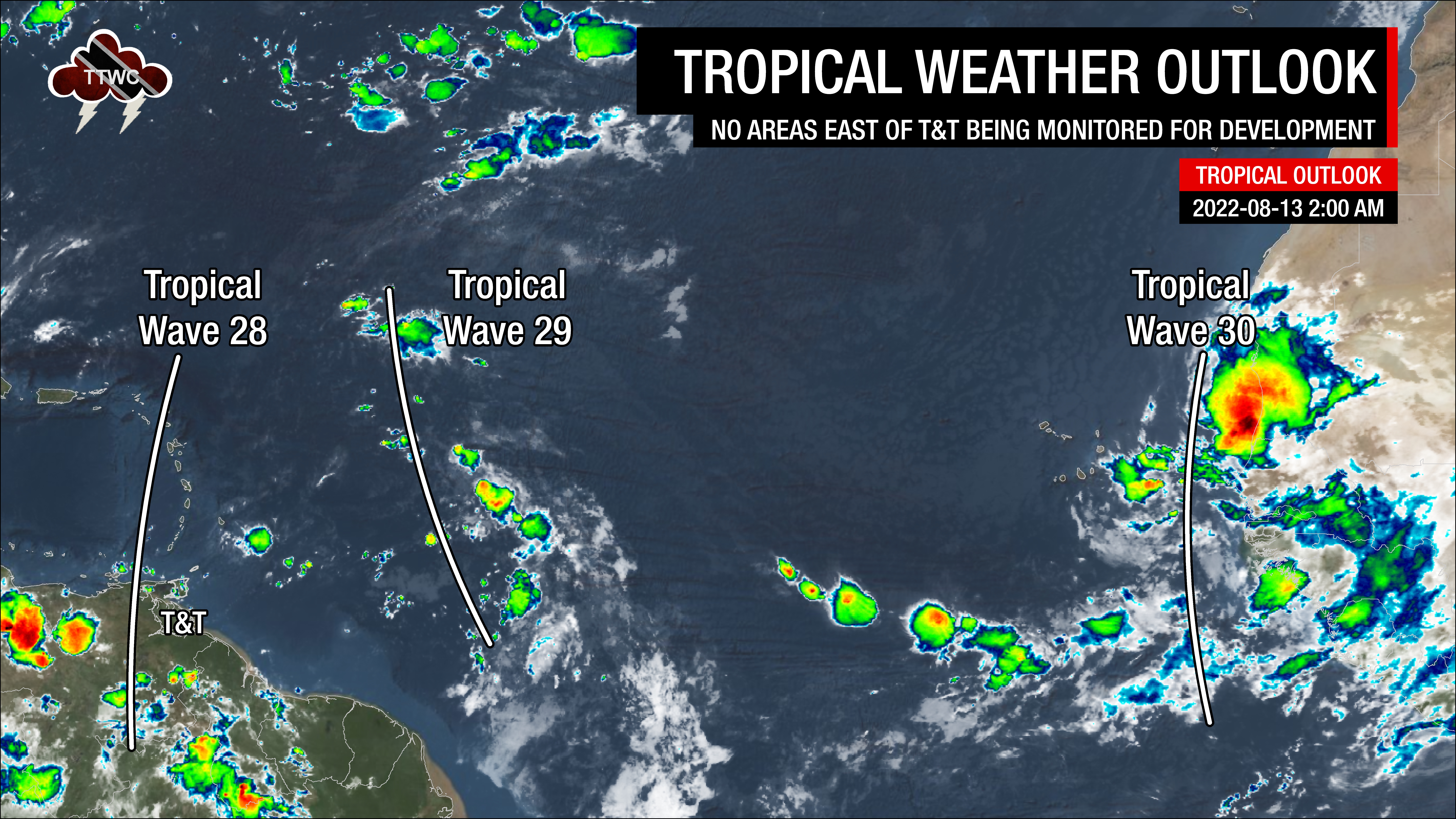
Tropical Waves (and other features) near and east of T&T: Based on the Tropical Analysis and Forecast Branch’s 00Z surface analysis on August 13th, 2022, as well as the latest satellite and model guidance:
- The 28th tropical wave for 2022 (TW28) is along 64°W, south of 20°N, moving west at 10 to 15 knots (18-28 KM/H). Isolated showers are ongoing following the passage of this wave inland northeastern Venezuela and across Trinidad. This wave moved across T&T on Friday night.
- The 29th tropical wave for 2022 (TW29), previously INVEST 97L, extends between 22°N, 55°W, and 8°N, 50°W, moving west at 15-20 knots (28-37 KM/H). A broad surface trough (Monsoon Trough) and abundant moisture are associated with this tropical wave. Scattered showers and thunderstorms have been noted with this wave, mainly where the wave axis interacts with the Monsoon Trough. The trough and wave axis are forecast to move west of the Lesser Antilles over the weekend.
- The 30th tropical wave for 2022 (TW30) is along 20°W, south of 20°N, moving west at 5-10 knots (9-18 KM/H). A 1008-millibar low pressure is along the wave axis near 14°N20°W. Isolated to scattered moderate convection is noted from 12°N-20°N between 22°W and the west coast of Africa. Scattered showers are seen from 05°N-10°N between 13°W-22°W. This wave is forecast to move across the Lesser Antilles by next Saturday, though Saharan Dust is forecast to limit moisture.
Over the weekend, moist and unstable are forecast across Trinidad and Tobago, leading to generally favorable conditions for cloudiness, rain, showers, and thunderstorms to develop.
TW28 moved across Trinidad, Tobago, and the Lesser Antilles on Friday night, bringing the first surge of moisture which sustained showers and isolated thunderstorms across Trinidad on Friday afternoon into the evening. This tropical wave also brought an ITCZ-like feature, called the Monsoon Trough, across T&T.
What is the Monsoon Trough?
Trinidad and Tobago is occasionally affected by the Intertropical Convergence Zone – where the northeasterly and southeasterly trade winds converge, leading to a band of cloudiness, showers, and thunderstorms that stretch across the Tropical Atlantic Ocean.
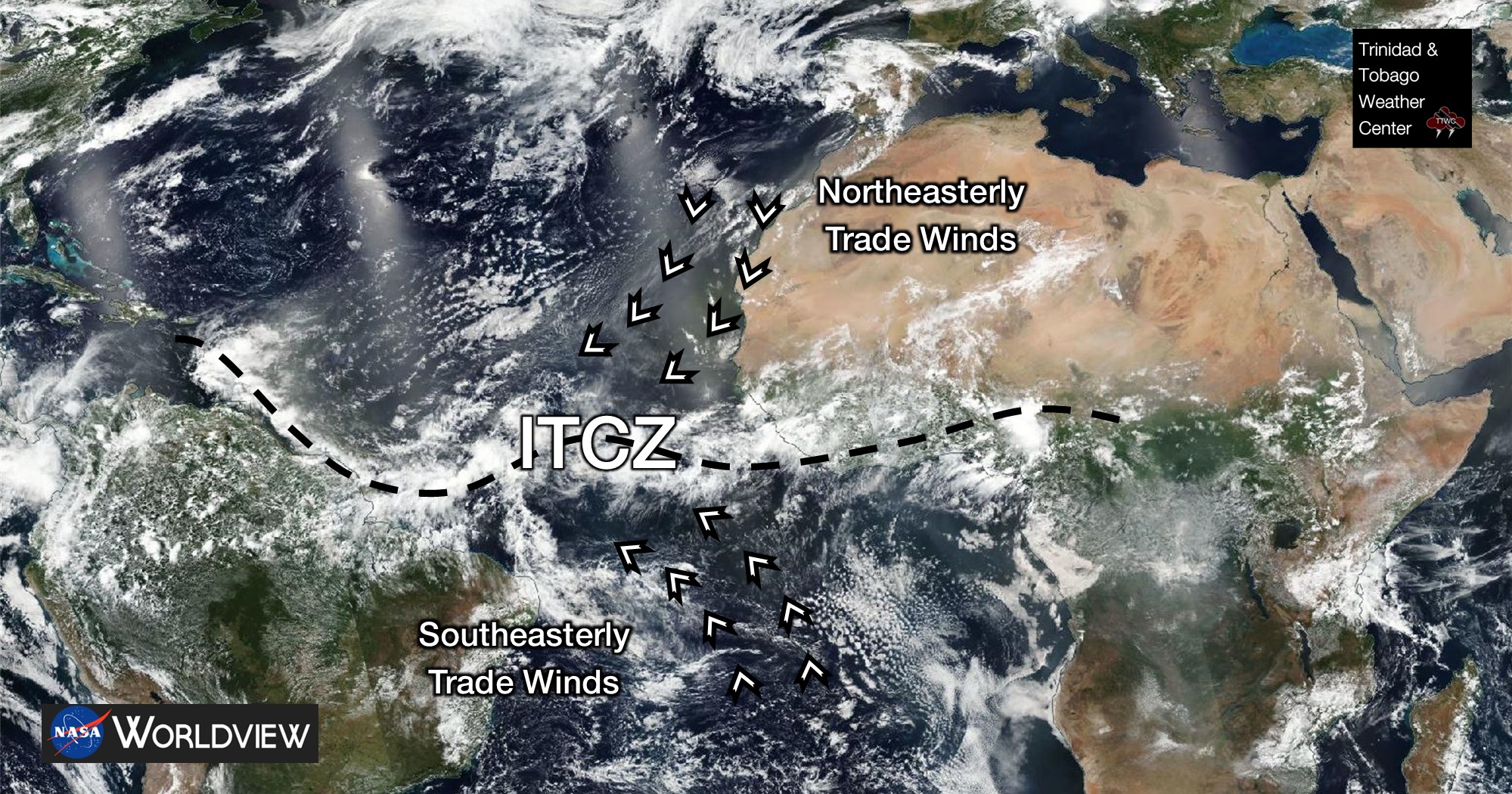
However, at times, these southeasterly tradewinds can be reversed. Instead of winds coming from the southeast, winds may come from the southwest. This is an unusual pattern, but not unheard of, near Trinidad and Tobago. It generally occurs when highly amplified tropical waves with broad areas of low pressure or when a tropical cyclone nears the Lesser Antilles, reversing the generally east-to-west wind regime.

The National Hurricane Center defines the Monsoon circulation as “A large-scale, seasonally-reversing surface wind circulation in the tropics accompanied by large amplitude seasonal changes in precipitation.” They define the Monsoon Trough as “A surface trough associated with a monsoon circulation. This is depicted by a line on a weather map showing the location of minimum sea level pressure coinciding with the maximum cyclonic turning of the surface winds, with southwesterly or northwesterly flow prevailing equatorward and northeasterly flow
prevailing poleward of the typically zonally oriented trough axis.”
Weather-wise, both the ITCZ and the Monsoon Trough bring light and variable winds, increased atmospheric moisture, and a natural area of convergence – all of which can lead to hot temperatures under sunny skies and fuel for strong showers and thunderstorms, particularly during the afternoon and favoring western/hilly areas of T&T after a sunny day. Showers or thunderstorms may also have an atypical movement when these features are over T&T – moving south to north or west to east.
As mentioned above, the presence of this trough will slacken the pressure gradient across the region, leading to light and variable winds over the weekend. TW29 is forecast to move through the Lesser Antilles on Saturday into Sunday, with the highest moisture and instability associated with the wave remaining north of Trinidad and Tobago.
Still, across T&T, with light winds, low to moderate shear, high atmospheric moisture, and high instability, mid to upper-level conditions are forecast to support deep convective activity through Sunday afternoon.
Localized climatic effects are also forecast to play a role in this weekend’s rains. Across areas that experience sunshine during the mid to late morning, this heating of the low levels of the atmosphere will add additional instability into the mix – what we usually call daytime heating – and trigger showers and thunderstorms. With light winds, at times coming from the south, both sea breeze convergence and orographic effects (particularly across Trinidad’s Southern, Central, and Northern Ranges, as well as Tobago’s Main Ridge) are forecast to enhance the development of showers or thunderstorms. This will increase the flood potential across Central and Northern Trinidad, as well as Tobago, through Sunday under intense shower or thunderstorm activity.
However, even at this eleventh hour, as of their August 13th 00Z runs, the two top leading models – the American GFS and the European ECMWF – are in stark contrast to overall rainfall totals. The GFS, which tends to have a better handle on overall precipitation outputs, shows daily rainfall totals up to 50 millimeters across Trinidad with isolated higher totals. The ECMWF, which performs better on modeling the types of weather conditions T&T may experience, shows a mostly sunny day after a few early morning showers and thunderstorms, leading to very low precipitation totals. Why the stark difference? A pocket of relatively drier air is currently off French Guiana’s coast. The GFS shows this airmass increasing in moisture as it moves across T&T and the Windwards late Saturday into Sunday, while the ECMWF keeps this airmass dry. Our forecast takes a blend of both models and other top global model guidance, which places a tempering hand on the GFS’ modeled outlook for the weekend. If the ECMWF forecast plays out, this weekend’s Adverse Weather Alert may seem unwarranted. However, if the GFS forecast materializes, there may be another flood and landslide event on our hands mere days after our last.
Trailing convergence, in the form of a surface to mid-level shearline, is forecast to linger through late Sunday through early Monday, with a substantial decrease in moisture across Trinidad and Tobago. Conditions north of T&T are forecast to settle earlier by Sunday afternoon.
This decrease in moisture by early Monday is associated with a rebuilding high-pressure system across the area and a moderate to high-concentration surge of Saharan Dust, which is forecast to remain across the region through the middle of the upcoming week. Higher concentrations are forecast to stay north of Trinidad and Tobago.
As winds increase by Tuesday and the atmosphere remains fairly dry, shower and thunderstorm development is forecast to be hindered, with low-level cloud patches bringing brief showers while localized climatic effects lead to isolated afternoon rainfall favoring western areas of Trinidad.


