


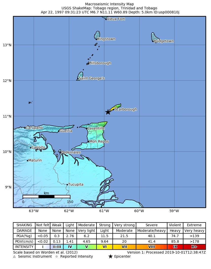
On April 22nd, 1997, the largest earthquake to strike near Tobago in recorded history occurred at 5:31 AM. It struck south of Tobago, registering a moment magnitude of (MW) 6.7 and a duration magnitude of (Mt or md) 6.1 by the University of the West Indies Seismic Research Center (SRC).
This strong earthquake is one of the few damaging quakes that affected Trinidad and Tobago, resulting in millions of dollars in damages, several injured and two homeless.
The Earthquake Sequence
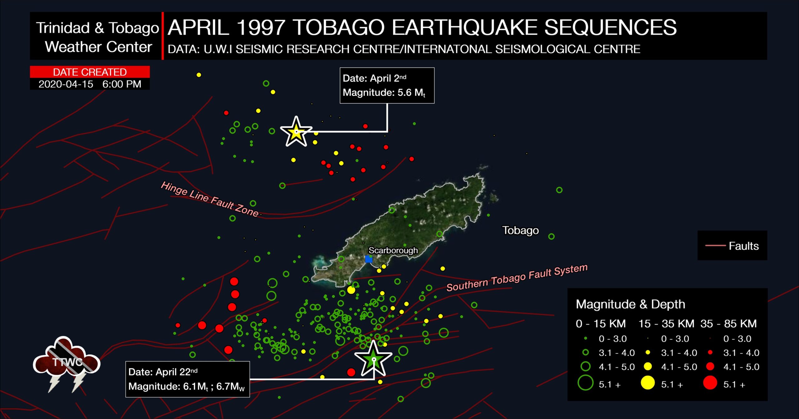
The April 1997 Tobago seismic sequence consisted of two subsequences. On 2nd April, the first sequence began with a magnitude Mt 5.6 (SRC) mainshock west of Tobago. This earthquake also produced damage across Southwestern Tobago. That sequence ran its course over a 2-day period, with most of the earthquakes in the area west of Tobago occurring during that time.
On April 4th, 1997, foreshock activity began in the area south of Tobago that would build to the magnitude (MW) 6.7 mainshock on April 22nd, 1997. This was part of a seismic sequence of over three hundred (>300) located events and 500 overall events.
The highest level of seismic activity occurred during April 1997, with over 200 earthquakes. Aftershocks continued through the end of 1997 when seismic activity returned to background levels.
The first sub-sequence could be identified by its clear difference in depth, geometry, and kinematics from the second sub-sequence, which produced the magnitude (MW) 6.7 quake. Events that occurred north and west of Tobago generally occurred at depths of 35-50 kilometers, while those south of Tobago were notably shallower, between 5 and 15 kilometers. These depths were recorded by both the SRC and the United States Geological Survey National Earthquake Information Center (NEIC).
Based on research, it is posited that the magnitude (Mt) 5.6 triggered the (MW) 6.7 quake, even though these events occurred on different faults and fault planes.
The difference in magnitudes
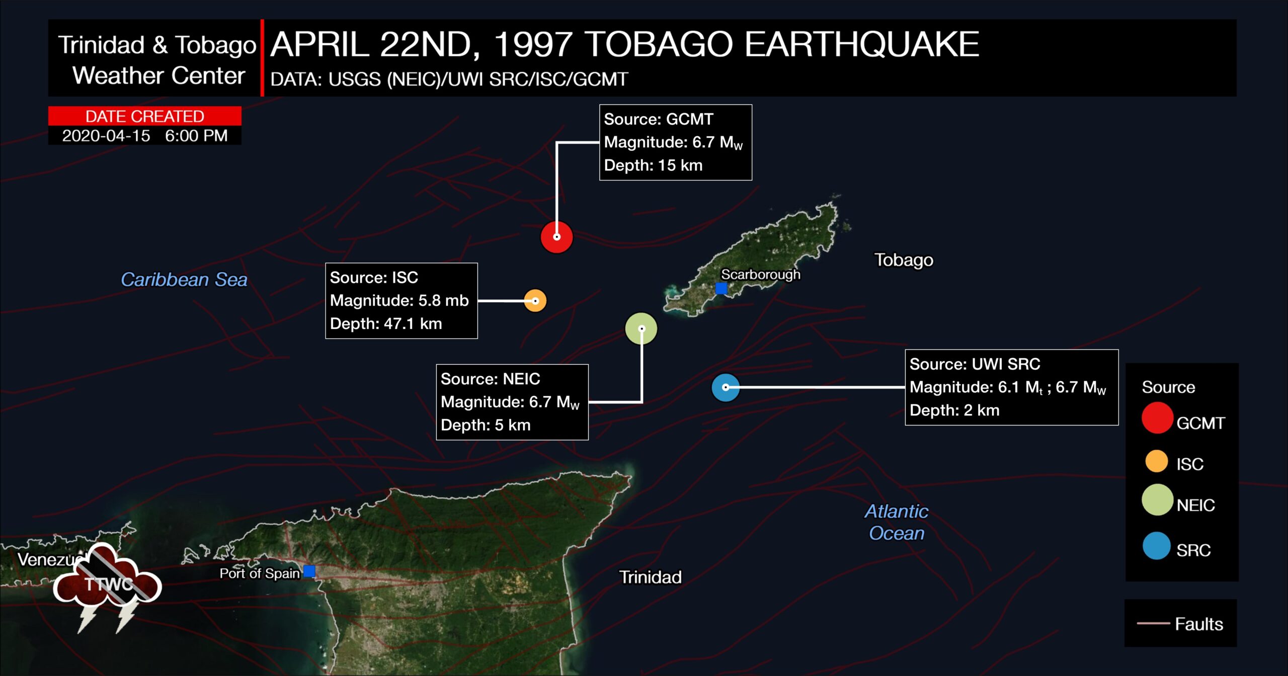
Across the globe, seismic monitoring agencies use various methods, or combinations of methods, to process earthquake parameters. Each method has its limitations and will likely produce different results within the range of that data’s uncertainty. This is generally accepted within the scientific community.
In addition, differences among the above determinations reflect, to some extent, the uncertainty involved in locating earthquakes in this region due to local and global differences in velocity models and the seismic phases used in calculations.
Read More

How did the Venezuelan Earthquakes Affect T&T?

Earthquake Magnitude & Intensity
Ground Movement
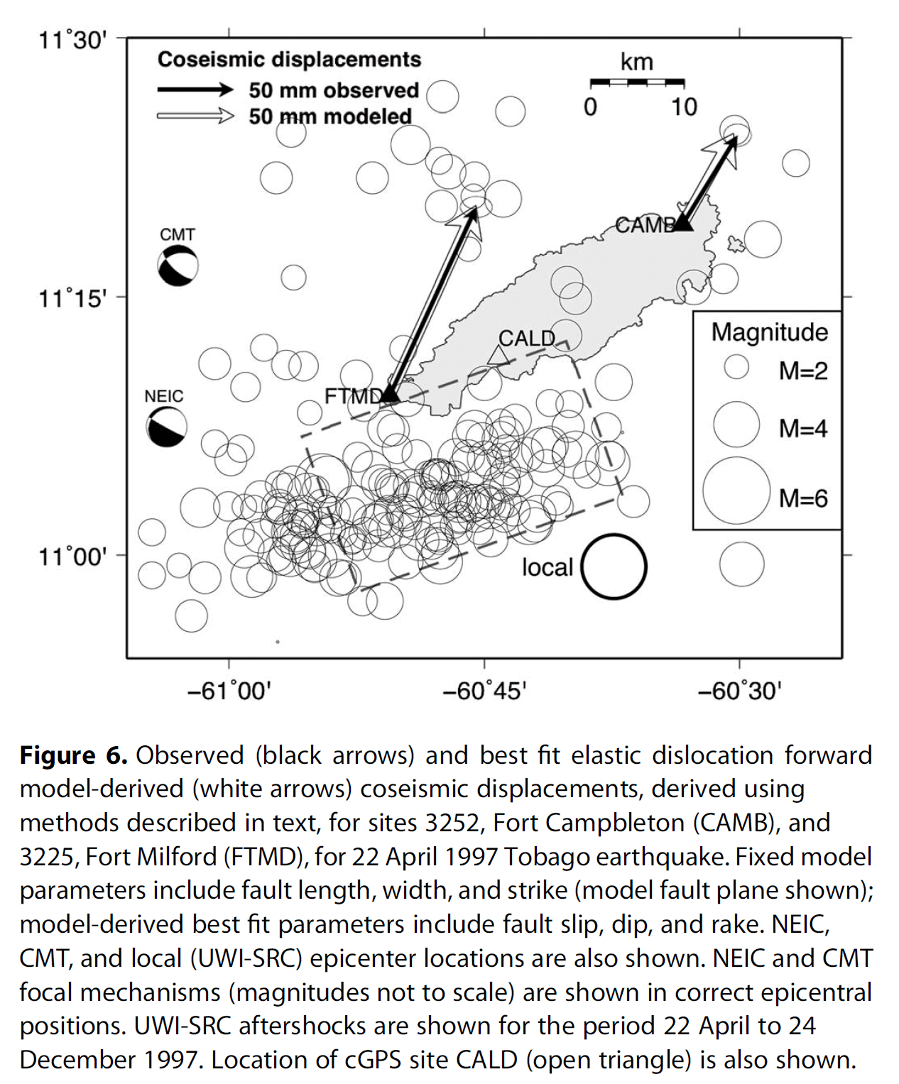
Based on research and GPS observations published in the American Geophysical Union Tectonics Journal, GPS sites in Tobago had measurable movement following the mainshock.
In Southern Tobago, closer to the epicenter of the Mt 6.1 earthquake, researchers estimated a northward displacement of 123 (±5) mm, an eastward displacement of 57 (±7) mm, and a vertical displacement of -7 (±9) mm. This means that overall, the site moved towards the northeast and sank.
In Northeastern Tobago, farther from the epicenter of the quake, researchers estimated a northward displacement of 58 (±5) mm and an eastward displacement of 36 (±6) mm. However, the vertical displacement was highly uncertain at 4 (±18) mm, based on their modeling.
The Ground Shaking
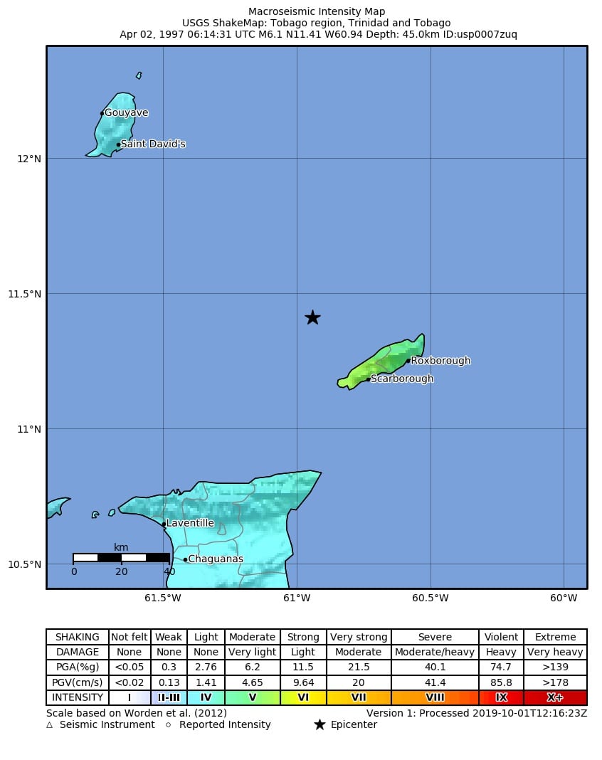
Based on USGS reports, moderate shaking was reported from the first large quake, magnitude (md) 5.6, internationally (MW) 6.1, with a Modified Mercalli Intensity (MMI) of V, which indicates light damage is possible.
Based on reports from the University of the West Indies Seismic Research Center, felt reports from this first quake indicated the highest MMI of VII, which indicates very strong shaking and moderate damage in southwestern Tobago, with light to moderate shaking elsewhere across the island.
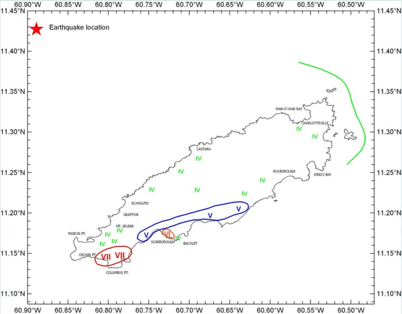
For the larger magnitude (MW) 6.7, the recorded MMI was VII, indicating very strong shaking and moderate damage, according to the USGS.
The Aftermath
On April 2nd, 1997, a magnitude 5.6 earthquake (Mt or md) struck at 2:45 AM, causing one home to collapse and damaging several buildings.
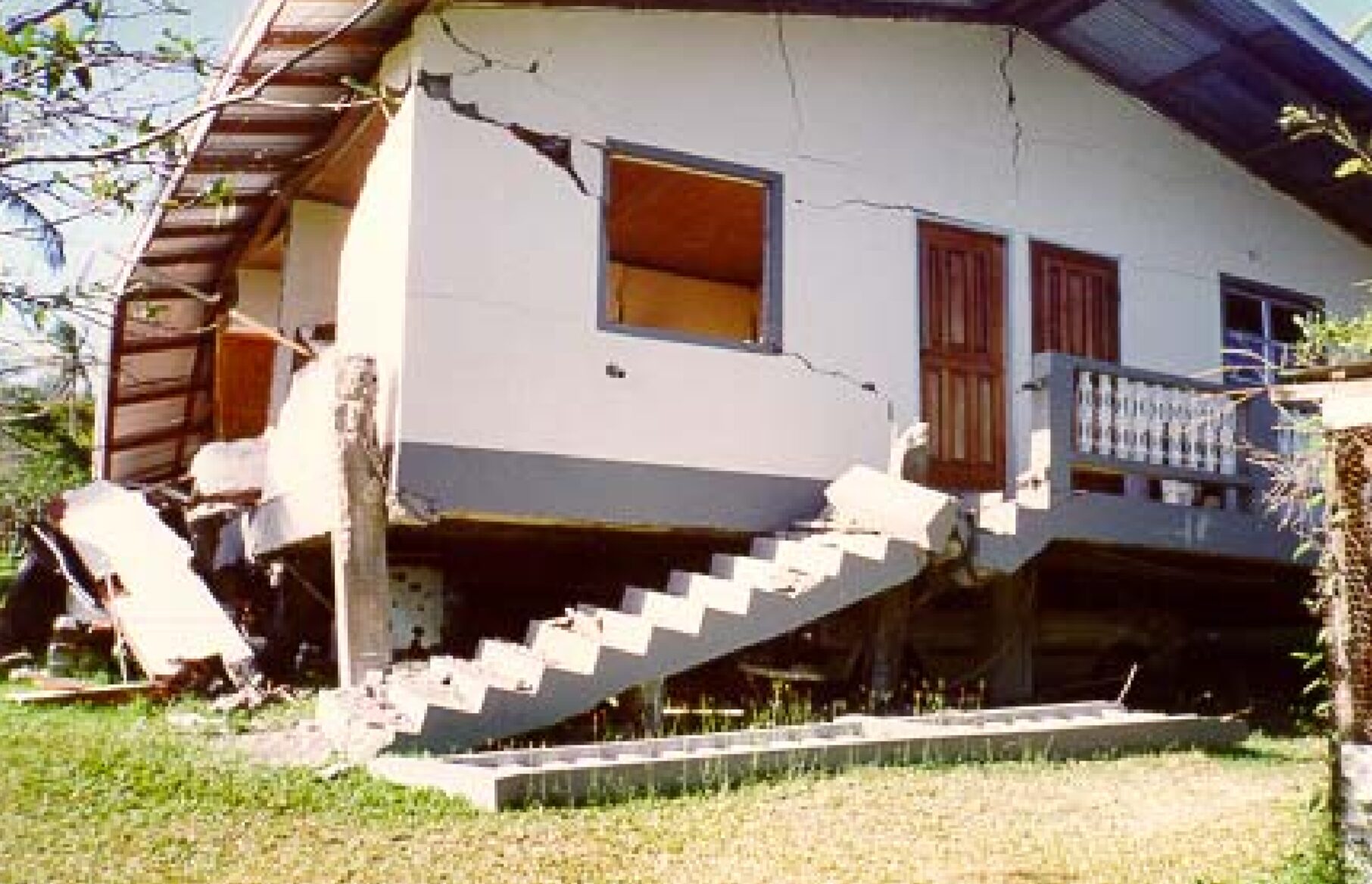
Following the magnitude (MW) 6.7 quake on April 22nd, 1997, six homes collapsed, and more than thirty (30) houses and buildings were damaged, according to media reports. These buildings included the NIB mall in Tobago, Tobago’s PTSC Central Bus Terminal, the Scarborough library, and the post office.
Over 15 people were left homeless. Two people were injured, one of whom was a woman who was hurt in Canaan-Bon Accord Village in Western Tobago after her home suffered unspecified damage.
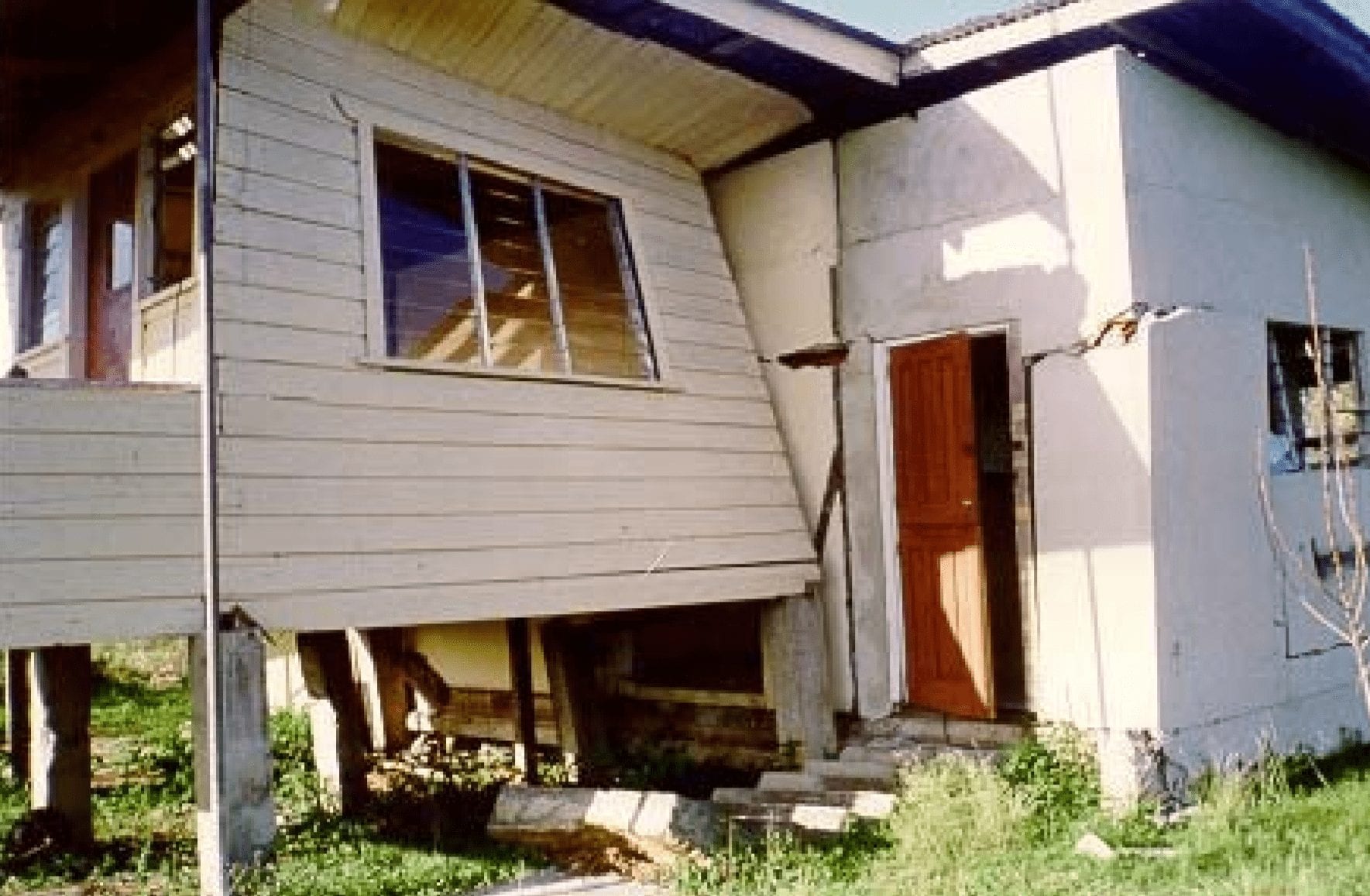
This quake left millions in damage across the island, estimated at 18 million dollars.
Why was this quake more damaging than the earlier magnitude (md) 5.6? Based on research, the ground shaking from both quakes caused a significant increase in groundwater discharge, which in some cases threatened building foundations. This increased groundwater discharge was restricted to south-west Tobago between Shirvan Road in the west and Hillsborough West River in the east.
In addition, there was an increase in tree mortality in the area following the mt 6.1 quake, which has been linked to changes in groundwater.
No damages were reported in Trinidad. No tsunami was reported, as Tobago’s bathymetry is unfavorable for significant tsunami generation.
What’s next?
Earthquakes continue to occur in the region, albeit infrequently compared to other areas in the Trinidad and Tobago Region. A seismic swarm did occur beginning on December 7th, 2016, with a magnitude 6.1 (md) earthquake South of Tobago along the Southern Tobago Fault System. After over 450 recorded seismic events, earthquake activity returned to background levels by the end of March 2017.
According to the University of the West Indies Seismic Research Center, “Research into the 1982 Tobago earthquakes revealed the potential for earthquakes in the magnitude range 6.0-6.9, and the occurrence of the magnitude 6.1 earthquake supported that conclusion. Further research has strengthened the case for even larger magnitude earthquakes near Tobago.”
Hence, it is imperative that we not only practice “Drop. Cover. Hold.” during an earthquake, but also prepare for our “Big One.”
Read More

In our region, earthquakes can strike at any time and any place, so it is important to know how to keep yourself safe when one strikes.