Earthquake magnitude is a quantitative, mathematical calculation to measure the energy released at the source of an earthquake. On the other hand, earthquake intensity is the qualitative measurement of the strength of shaking produced by an earthquake.
Earthquake (Seismic) Magnitude Scales
Magnitude scales describe, numerically, the size of the earthquake using mathematical equations and characteristics from the seismic waves recorded on seismographs.
Determination of an earthquake’s magnitude generally involves identifying specific types of seismic waves on a seismogram and then measuring one or more characteristics of a wave, such as its timing, orientation, amplitude, frequency, or duration. Additional adjustments are usually made for distance, kind of crust, and the characteristics of the seismograph that recorded the seismogram.
The various magnitude scales represent different ways of deriving magnitude from information as it is available. All magnitude scales retain the logarithmic scale as devised by Charles Richter, and are adjusted so the mid-range approximately correlates with the original “Richter” scale.
There are several magnitude scales that are used across the world. Comprehensive and technical information can be found on the USGS website. In the Eastern Caribbean, there are some that are frequently used.
Richter Magnitude Scale (ml, ML, ML)
The Richter Magnitude, or local magnitude scale, was the first scale for measuring earthquakes. It was developed in 1935 by Charles F. Richter. Richter established two features now common to all magnitude scales.
How is the ML Scale Calculated?
The original Richter scale was developed to relate the amplitude of a seismic wave and the distance of the S and P waves on the seismogram. It is based on the maximum amplitude of a seismogram recorded on a Wood-Anderson torsion seismograph. Although these instruments are no longer widely in use, ML values are calculated using modern instrumentation with appropriate adjustments.
The most important, and widely known fact about this scale is that it is logarithmic. Each unit represents a ten-fold increase in the amplitude of the seismic waves and each unit of magnitude represents a nearly 32-fold increase in the energy (strength) of an earthquake.
Limitations
All “Local” (ML) magnitudes are based on the maximum amplitude of the ground shaking, without distinguishing the different seismic waves. They underestimate the strength of:
- distant earthquakes (over ~600 km) because of attenuation of the S-waves,
- deep earthquakes because the surface waves are smaller, and
- strong earthquakes (over M ~7) because they do not take into account the duration of shaking.
Because of these shortcomings, other magnitude scales were developed.
In Trinidad and Tobago, this scale is rarely used. In the few occurrences, it is utilized by international seismological organizations, such as the USGS, it is because no other types of magnitude using available scales were able to be calculated.
This type of scale is used for earthquakes of magnitudes 2.0 to 6.5, at distances of 0 to 600 kilometers away from seismometers.
Body Wave Magnitude Scale (mb)
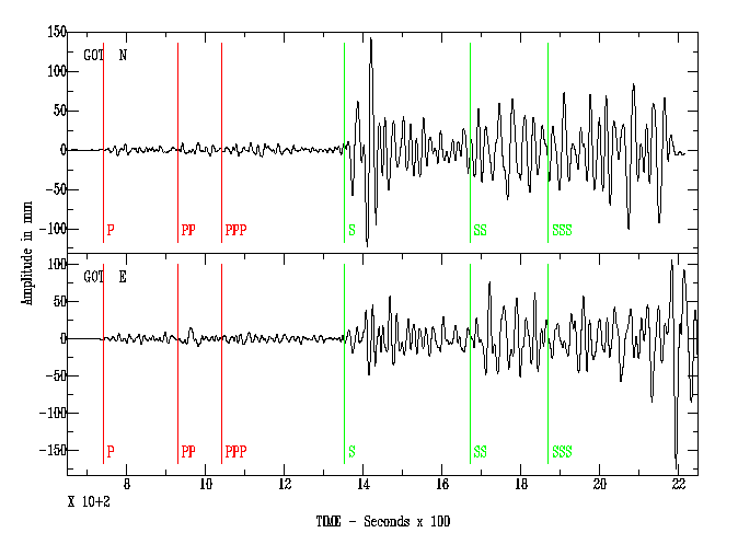
Body waves consist of P-waves that are the first to arrive (see above seismogram), or S-waves, or reflections of either. Body waves travel through rock directly. (Havskov & Ottemöller 2009)
While there are several iterations of body magnitude scales, most times in the Trinidad and Tobago region, if this scale is used, the mb iteration is reported.
How is the mb Scale Calculated?
The mb or mb scale uses only P-waves measured in the first few seconds on a specific model of a short-period seismograph. The short period improves the detection of smaller events.
The measurement of mb has changed several times. The modern practice by the USGS is to measure the short-period mb scale at less than three seconds, while the broadband mBBB scale is measured at periods of up to 30 seconds.
Limitations
The mb scale is typically used for earthquakes of magnitude 4.0 to 6.5, at distances of 15 to 100 degrees away from the seismometer.
It is reported for most M4.0-4.5 to 6.5 earthquakes that are observed teleseismically (recorded far distances from the earthquake source). Typically, a light (M4.0-4.9) or moderate (M5.0-5.9) earthquake occurs near Trinidad and Tobago, this type of magnitude is published by the USGS.
Mb tends to saturate at about M 6.5 or larger.
Moment Magnitude (MW or Mw)
The Moment Magnitude (MW or Mw) is a measure of an earthquake’s magnitude based on its seismic moment (the energy released). Its numerical value is similar to the magnitudes on the original Richter Scale.
How is the MW Scale Calculated?
The MW scale is based on an earthquake’s seismic moment. This is a measure of how much work an earthquake does in sliding one area of rock past another area of rock.
In the simplest case, the moment can be calculated knowing only the amount of slip, the area of the surface ruptured or slipped, and a factor for the resistance or friction encountered.
These factors can be estimated for an existing fault to determine the magnitude of past earthquakes, or what might be anticipated for the future.
Our neighboring seismological organization, the Venezuelan Foundation for Seismological Research (FUNVISIS), typically publishes the MW magnitude as their earthquake solutions.
An earthquake’s seismic moment can be estimated in various ways, which are the bases of the Mwb, Mwr, Mwc, Mww, Mwp, Mi, and Mwpd scales, all subtypes of the generic Mw scale.
In the Trinidad and Tobago region, these values are typically calculated and published by international seismological centers such as the USGS or GFZ.
Generally, for larger events, the USGS (NEIC) publishes the Mwb, Mwc, and most commonly the Mww magnitudes. FUNVISIS publishes the Mwr for larger events.
The differences amongst these MW magnitude types are fairly complex geophysical and mathematical calculations but are generally seen as the most accurate in determining the magnitude of larger earthquakes, generally above M6.0.
Mww is generally calculated by USGS for all M5.0 or larger earthquakes worldwide but is generally robust for all M5.5 worldwide. It provides consistent results to M~4.5 within a regional network of high-quality broadband stations. It is the authoritative USGS magnitude if computed. The August 21st, 2018 earthquake magnitude by the USGS was Mww 7.3, versus the UWI SRC’s magnitude of M6.9 (more on this below).
Mw and Mwr are usually calculated by FUNVISIS, with Mwr for larger events, within their area of responsibility. Generally, source complexity and dimensions at larger magnitudes (~M7.0 or greater) limit Mwr applicability. Mw magnitude is usually calculated there is there a large number of high-quality broadband stations, where Mw values can be calculated for events as small as M4.0. In FUNVISIS’ case, it is calculated for all magnitudes of earthquakes.
Limitations
Since the seismic moment is required for the calculation of a moment magnitude, this type of magnitude scale is generally used for quakes with magnitudes larger than M4.0 by the USGS. FUNVISIS, on the other hand, calculates the moment magnitude for all events.
Duration Magnitude Scale (Md, md OR Mt)
The duration magnitude is the magnitude that is published by the University of the West Indies Seismic Research Centre (Page 6) for all seismic events within their area of responsibility for the Eastern Caribbean.
Across the world, the duration magnitude is denoted by Md or md. At the UWI SRC, it is denoted by Mt. This should not be confused with the Tsunami magnitude of Mt.
How is the Duration Magnitude Scale Calculated?
Md designates various scales that estimate magnitude from the duration or length of some part of the seismic wave train. The seismic wave interval is measured on the time axis of an earthquake record – starting with the first seismic wave onset until the wavetrain amplitude diminishes to at least 10% of its maximum recorded value. This is referred to as “earthquake duration”.
Duration magnitude is especially useful for measuring local or regional earthquakes, both powerful earthquakes that might drive the seismometer off-scale (a problem with the analog instruments formerly used) and prevent measurement of the maximum wave amplitude, and weak earthquakes, whose maximum amplitude is not accurately measured.
Even for distant earthquakes, measuring the duration of the shaking (as well as the amplitude) provides a better measure of the earthquake’s total energy.
Earthquake (Seismic) Intensity Scales
Intensity measures the strength of shaking produced by the earthquake at a certain location. It is determined by its effects on people, human structures, and the natural environment. Intensity is typically represented by Roman numerals, to emphasize the point of it being an integer value historically. However, in the age of technology, most seismologists use Arabic numerals. (Musson et al., 2012)
The use of intensity scales is historically important because no instrumentation is necessary, and useful measurements of an earthquake can be made by an unequipped observer. This is how we can estimate the magnitude of historical earthquakes in the Caribbean before seismometers were present.
The first scale to be used internationally was the ten-degree Rossi-Forel Scale of 1883. The scale of Sieberg became the foundation of all modern twelve-degree scales.
Across the modern world, there are three intensity scales that are predominantly used to characterize earthquake shaking and earthquake damage:
- The Japan Meteorological Agency Shindo or Seismic Intensity Scale
- The European Macroseismic Scale
- The Modified Mercalli Intensity Scale (below)
Modified Mercalli Intensity Scale
The Modified Mercalli intensity scale (MM or MMI), descended from Giuseppe Mercalli‘s Mercalli intensity scale of 1902, is a seismic intensity scale used for measuring the intensity of shaking produced by an earthquake.
This scale is generally used by most countries and seismological agencies across the world, including Trinidad and Tobago.
Most versions of the MMI that are typically found on the internet are abridged versions or some arrangement and/or amalgamation of different published definitions of the MMI. A comprehensive (i.e. another amalgamation) MMI is presented below, taking into account the works of Stover & Coffman (1993), Wood & Neumann (1931), and edits from Musson.
Generally, the lower degrees of the Modified Mercalli Intensity scale generally deal with the manner in which the earthquake is felt by people. The higher numbers on the scale are based on observed structural damage and are assigned by structural engineers.
| MMI | Peak Ground Acceleration (g) | Effects |
| I – Not Felt | <0.001 | Not felt – or rarely under especially favorable circumstances. Under certain conditions, at and outside the boundary of the area in which a great shock is felt: sometimes birds, animals reported uneasy or disturbed; sometimes dizziness or nausea experienced; sometimes trees, structures, liquids, bodies of water may sway – doors may swing very slowly. |
| II – Weak | 0.001-0.002 | Felt indoors by few, especially on upper floors, or by sensitive or nervous persons. Also, as in grade I, but often more noticeably: sometimes hanging objects may swing, especially when delicately suspended; sometimes trees, structures, liquids, bodies of water may sway; doors may swing very slowly; sometimes birds, animals reported uneasy or disturbed; sometimes dizziness or nausea experienced. |
| III – Weak | 0.002-0.005 | Felt indoors by several, motion usually rapid vibration. Sometimes not recognized to be an earthquake at first. Duration is estimated in some cases. Vibration is like that due to the passing of light, lightly loaded trucks, or heavy trucks some distance away. Hanging objects may swing slightly. Movements may be appreciable on the upper levels of tall structures. Rocked standing motor cars slightly. |
| IV – Light | 0.005-0.01 | Felt by many to all. Trees and bushes shaken slightly. Buildings shook moderately to strongly. Walls creaked loudly. Observer described the shaking as “strong.” Awakened a few, especially light sleepers. Frightened no one, unless apprehensive from previous experience. Vibration is like that due to heavily loaded or heavy trucks passing. Sensation like heavy body striking building or falling of heavy objects inside. Rattling of dishes, windows, doors, glassware, and crockery clink and clash. Hanging objects swung in numerous instances. Disturbed liquids in open vessels slightly. Rocked standing motor cars noticeably. |
| V – Moderate | 0.01-0.025 | Buildings trembled throughout. Broken dishes and glassware, to some extent. Cracked windows – in some cases, but not generally. Overturned vases, small or unstable objects, in many instances, with occasional falls. Hanging pictures fall. Opened or closed doors, shutters abruptly. Pendulum clocks stopped, started, or ran fast or slow. Moved small objects, furnishings, the latter to a slight extent. Trees and bushes, shaken moderately to strongly. People have difficulty standing or walking. Felt moderately by people in moving vehicles. |
| VI – Strong | 0.025-0.051 | Damage slight in poorly built buildings. Fall of plaster in a small amount. Cracked plaster somewhat, especially fine cracks in chimneys in some instances. Broke dishes, glassware, in considerable quantity, and also some windows. Fall of knickknacks, books, pictures. Overturned furniture in many instances. Moved furnishings of moderately heavy kind. Small bells rang – church, chapel, school, etc. The intensity can only be assessed as VI if damage to buildings is observed unless many small objects fall from shelves or many glasses or dishes are broken. |
| VII – Very Strong | 0.051-0.102 | Damage is negligible in buildings of good design and construction, slight to moderate in well-built ordinary buildings, considerable in poorly built or badly designed buildings, adobe houses, old walls (especially where laid up without mortar), spires, etc. Cracked chimneys to a considerable extent, walls to some extent. Fall of plaster in considerable to a large amount, also some stucco. Broke numerous windows, and furniture to some extent. Shook down loosened brickwork and tiles. Broke weak chimneys at the roofline (sometimes damaging roofs). Fall of cornices from towers and high buildings—dislodged bricks and stones. |
| VIII – Severe | 0.102-0.255 | Damage is slight in structures (brick) built especially to withstand earthquakes. Considerable in ordinary substantial buildings, partial collapse: racked, tumbled down, wooden houses in some cases; threw out panel walls in frame structures, broke off decayed piling. Fall of walls. Cracked, broke, solid stone walls seriously. Twisting, fall, of chimneys, columns, monuments, factory stacks, towers. Moved conspicuously, overturned very heavy furniture. Trees shaken strongly – branches, trunks, broken off, especially palm trees. |
| IX – Violent | 0.255-0.510 | Damage considerable in (masonry) structures built especially to withstand earthquakes: threw out of plumb some wood-frame houses built especially to withstand earthquakes; great in substantial (masonry) buildings, some collapse in large part; or wholly shifted frame buildings off foundations, racked frames. |
| X – Extreme | 0.510-1.019 | Damage is serious to dams, dykes, and embankments. Severe to well-built wooden structures and bridges, some destroyed. Developed dangerous cracks in excellent brick walls. Destroyed most masonry and frame structures also their foundations. |
| XI – Extreme | Damage severe to wood-frame structures, especially near shock centers. Damage is great to dams, dikes, and embankments, often for long distances. Few, if any (masonry) structures remained standing. Destroyed large, well-built bridges by the wrecking of supporting piers or pillars. Affected yielding wooden bridges less. | |
| XII – Extreme | Damage total – practically all works of construction are significantly damaged or destroyed. |
The UWI Seismic Research Centre also has an abridged version, which can be found on its website.
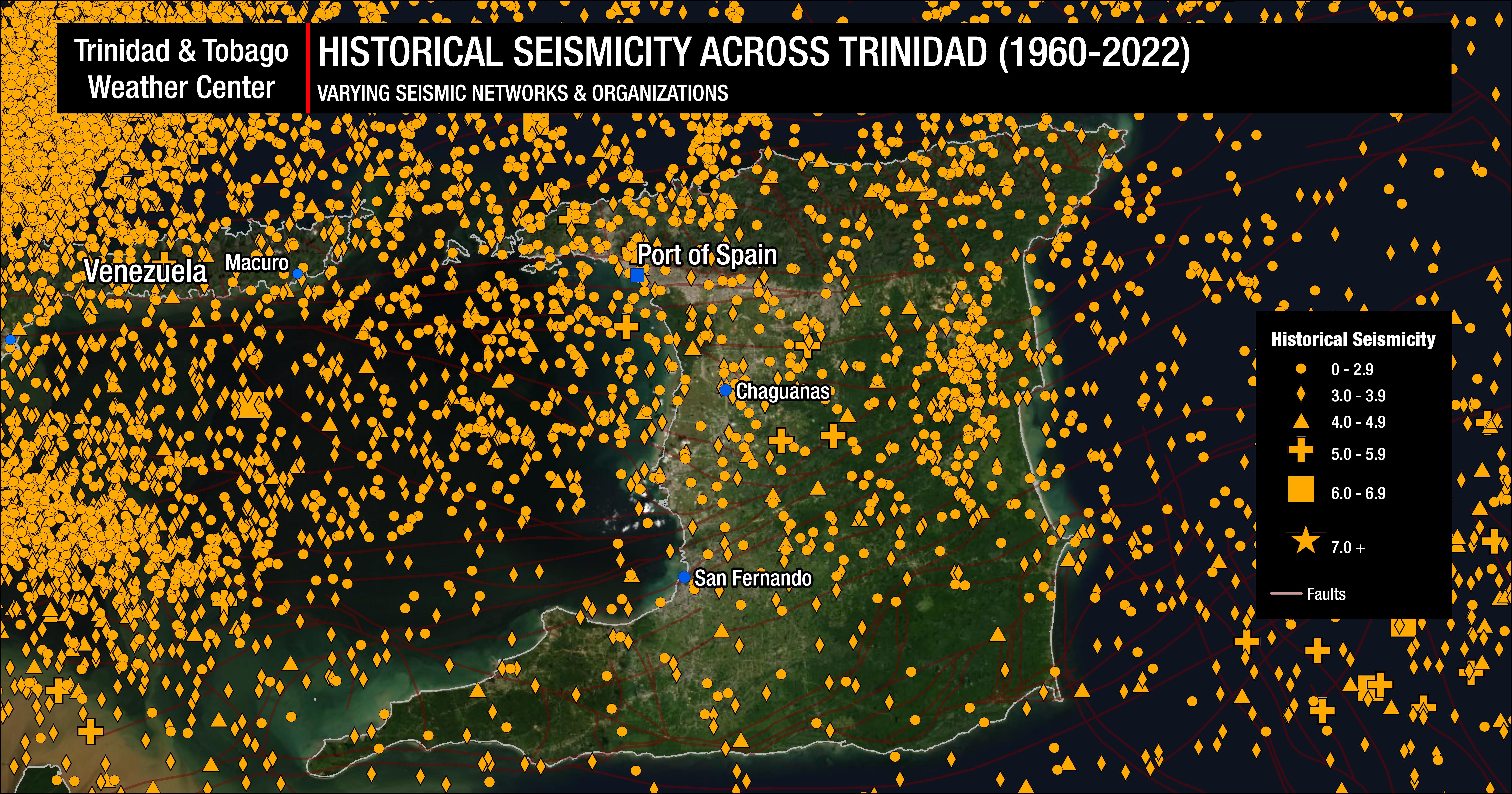
In Trinidad and Tobago, we generally experience events that cause shaking resulting in MMI values less than IV. With the strong M6.9 earthquake on 21st August 2018, the average MMI value was IV, with the maximum value of VIII.
Peak ground acceleration (PGA) is the effective Peak Ground Acceleration during an earthquake. That is the maximum horizontal ground acceleration excluding high-frequency spikes. PGA of the M6.9 quake in stations across Port of Spain ranged from 0.16g to 0.27g.
Earthquake Magnitude/Intensity Comparison
| Estimated Magnitude | MMI | Peak Ground Acceleration (g) |
| 1.0 – 3.0 | I – Not Felt | <0.001 |
| 3.0 – 3.9 | II – Weak | 0.001-0.002 |
| 3.0 – 3.9 | III – Weak | 0.002-0.005 |
| 4.0 – 4.9 | IV – Light | 0.005-0.01 |
| 4.0 – 4.9 | V – Moderate | 0.01-0.025 |
| 5.0 – 5.9 | VI – Strong | 0.025-0.051 |
| 5.0 – 7.0+ | VII – Very Strong | 0.051-0.102 |
| 6.0 – 7.0+ | VIII – Severe | 0.102-0.255 |
| 6.0 – 7.0+ | IX – Violent | 0.255-0.510 |
| 7.0+ | X – Extreme | 0.510-1.019 |
| 7.0+ | XI – Extreme XII – Extreme | At the highest intensity levels damage potential is determined increasingly by the effects of ground failure. Most types of ground are unable to sustain prolonged accelerations much greater than 0.510g, but has happened in strong quakes across the world. |
Hence, the above magnitudes may sometimes generate stronger or weaker shaking than expected. In turn, there may be higher or lower MMI values reported depending on the characteristics of the earthquake.
Shaking is driven by the seismic energy released by an earthquake. Earthquakes differ in how much of their energy is radiated as seismic waves. Deeper earthquakes also have less interaction with the surface, and their energy is spread out across a larger area. Shaking intensity is localized, generally diminishing with distance from the earthquake’s epicenter, but can be amplified in sedimentary basins and certain kinds of unconsolidated soils.
Which is the “correct” magnitude and location?
Across the globe, different seismic monitoring agencies use different methods, or several methods, for processing earthquake parameters. Each method has its limitations and will likely produce different results within the ranges of the uncertainty of that data. This is generally accepted within the scientific community.
Additionally, to meet the public’s need for information, seismological agencies have now begun publishing and updating information as an earthquake occurs. The data is usually automatically processed with limited data by computers and published either directly online for the public (USGS, EMSC, etc.), or sent to stakeholders, then to the public (U.W.I. SRC).
Because limited amounts of data are used for these preliminary outputs, it is common to see minor changes in latitude, longitude, depths, and magnitude.
Furthermore, because of the difference in magnitude types, you will likely see even more variation amongst seismic reports from different organizations (UWI SRC, FUNVISIS, USGS, BSCF (France), etc.).
However, nearly all international seismic monitoring agencies do not receive seismic data from FUNVISIS or UWI SRC. This means that in most cases, with reporting stations mainly north of T&T, the epicenter of quakes nearly always have a northward bias when it comes to latitude and longitude of a quake. It is also important to note that there is no exact location of a quake, as these seismic events occur due to a slip across a fault.
No matter how dense the seismic network is, there is always uncertainty which by the density of stations is reduced but never eliminated. When a solution is produced, the longitude and latitude are generated. All processing algorithms also provide the small and big axis of the eclipse with that location in the center, hence the location of an earthquake is not one point on the earth, but an area defined by those axes.
In Trinidad, Tobago & The Eastern Caribbean
In the case of Trinidad and Tobago, automated posts from the U.W.I. Seismic Research Centre are posted onto their social media platforms within minutes of the event. These events are always then reviewed by a seismologist or seismic analyst at the SRC. In most instances, the reviewed solution is then posted to their website.
There is usually a 10 km margin of error in latitude and longitude, but often tens of km in depth, between preliminary results and reviewed results (which is standard for monitoring agencies), magnitude tends to change as more data come to hand, even with manual processing.
Ultimately, there is no correct method to calculate magnitude as each method has its strengths and weaknesses. It is important to note that for Trinidad, Tobago and the remainder of the English-speaking Eastern Caribbean, the University of the West Indies Seismic Research Center is the authoritative agency for seismic hazards in the English-speaking Eastern Caribbean. It operates the widest and densest network of seismic stations in the region. Thus, it is likely to consistently yield the most accurate results for the islands under its area of responsibility, which includes Trinidad & Tobago.
What does a minor or light earthquake mean?
The Richter magnitude scale is a measure of the strength of earthquakes, which can also be used to qualitatively describe the strength of a quake based on the quantitative number.
| Magnitude | Qualitative Description | Mercalli Intensity |
| 1.0 – 1.9 | Micro | I |
| 2.0 – 3.9 | Minor | I – IV |
| 4.0 – 4.9 | Light | IV – VI |
| 5.0 – 5.9 | Modereate | VI – VII |
| 6.0 – 6.9 | Strong | VIII – X |
| 7.0 – 7.9 | Major | X or greater |
| 8.0+ | Great | X or greater |