


The Trinidad and Tobago Meteorological Service has discontinued the Adverse Weather Alert for T&T. While rivers and tributaries remain elevated, a slow and steady decrease is expected.
What you need to know
— What: A broad, deep-layered trough affected the Windward Islands, including Trinidad and Tobago, through Thursday, coupled with deep, tropical moisture. In addition, larger-scale environmental factors were also favorable, leading to periods of rain, isolated to scattered showers, and thunderstorms.
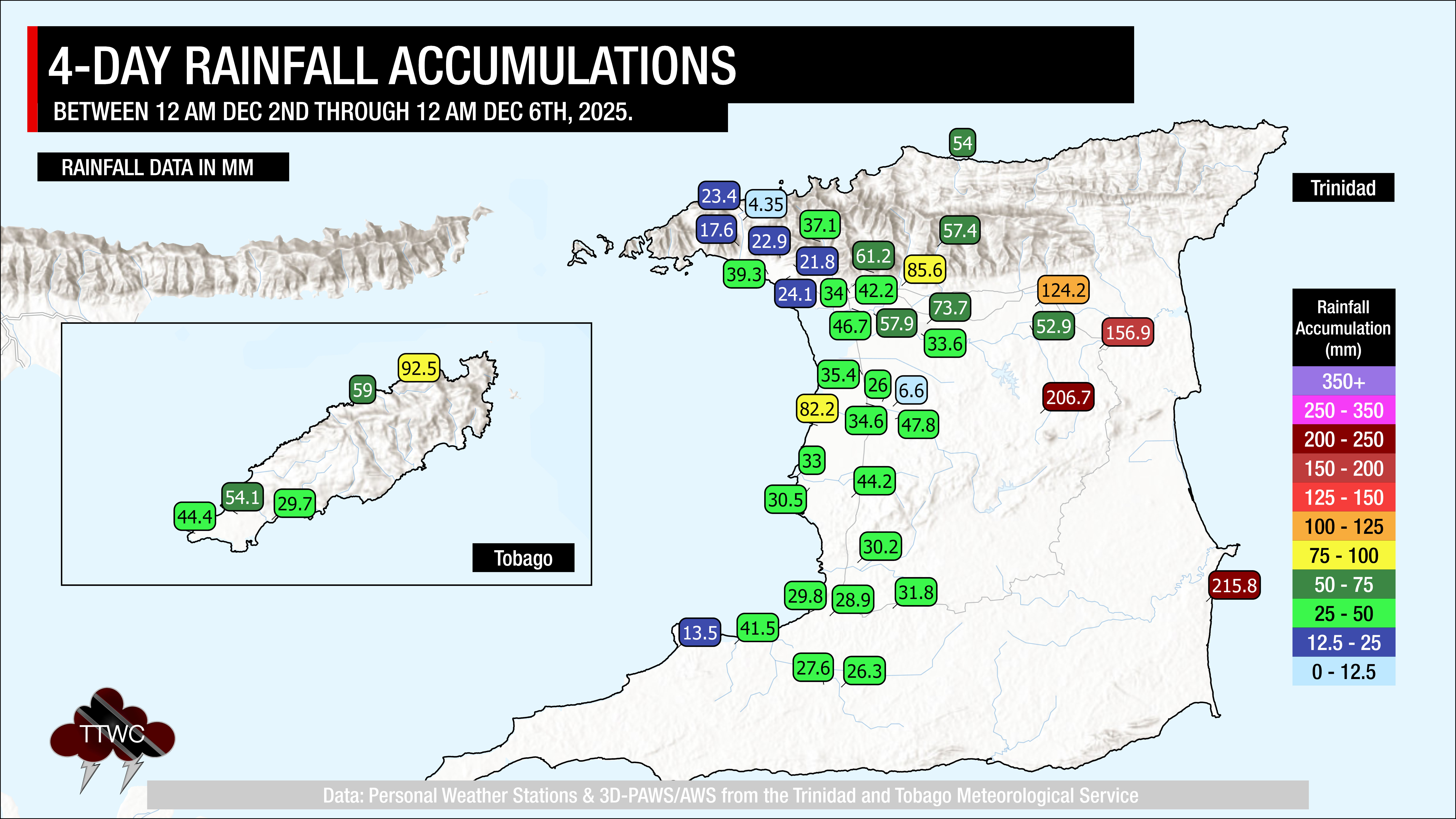
— Where: Through Thursday evening, both islands have recorded rainfall totals between 20 and 50 millimeters across the western half of Trinidad. Higher rainfall totals were recorded across north-central and eastern Trinidad and Tobago, with likely totals of 50 to 75 millimeters, with highly isolated totals peaking just over 200 millimeters, favoring eastern coastal areas.
— When: The Adverse Weather Alert has been discontinued for T&T as of 8:44 AM December 5th.
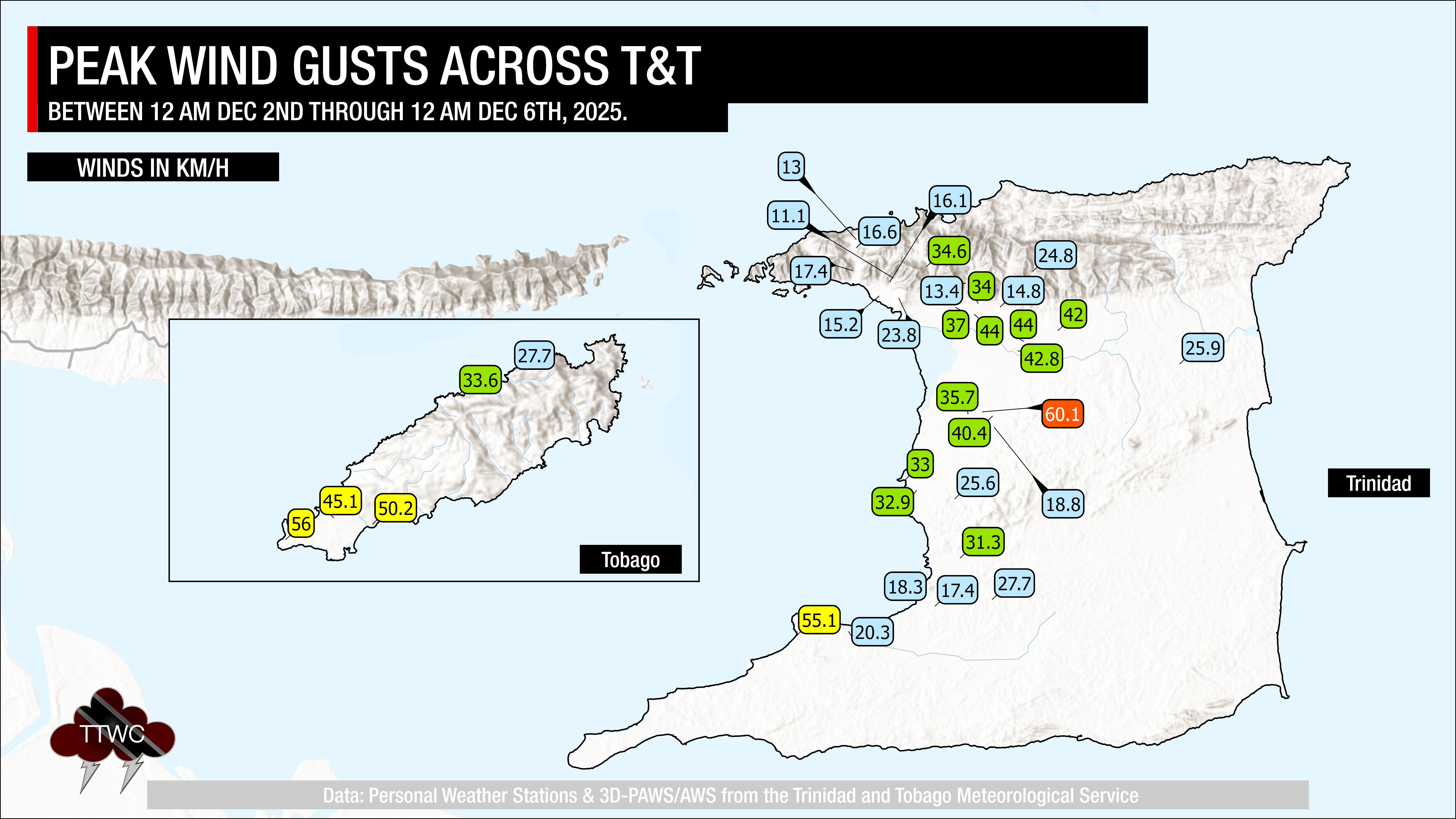
— Impacts: The potential for impactful rainfall has significantly decreased. However, low-level winds are forecast to increase on December 5th through 6th. These wind gusts, likely to exceed 45 km/h, combined with heavy rainfall, may lead to fallen trees/utility poles/lines, as well as landslides, localized wind damage, and agitated seas. Isolated heavy showers or the odd thunderstorm may produce localized and short-lived street/flash flooding, and localized ponding.
— What Should You Do: Motorists and residents in areas prone to landslides or flooding, especially along the Caroni River Basin and across northeastern and eastern Trinidad, should still monitor the situation and exercise caution. Be aware of your surroundings and changing weather conditions
Latest Alerts

Localized Flood Alert Discontinued For Trinidad
Trinidad and Tobago is NOT under any tropical storm or hurricane threat, watch, or warning at this time.
The Adverse Weather Alert Discontinuation
The Trinidad and Tobago Meteorological Service discontinued the Adverse Weather Alert (Yellow Level) on Friday at 8:55 AM.
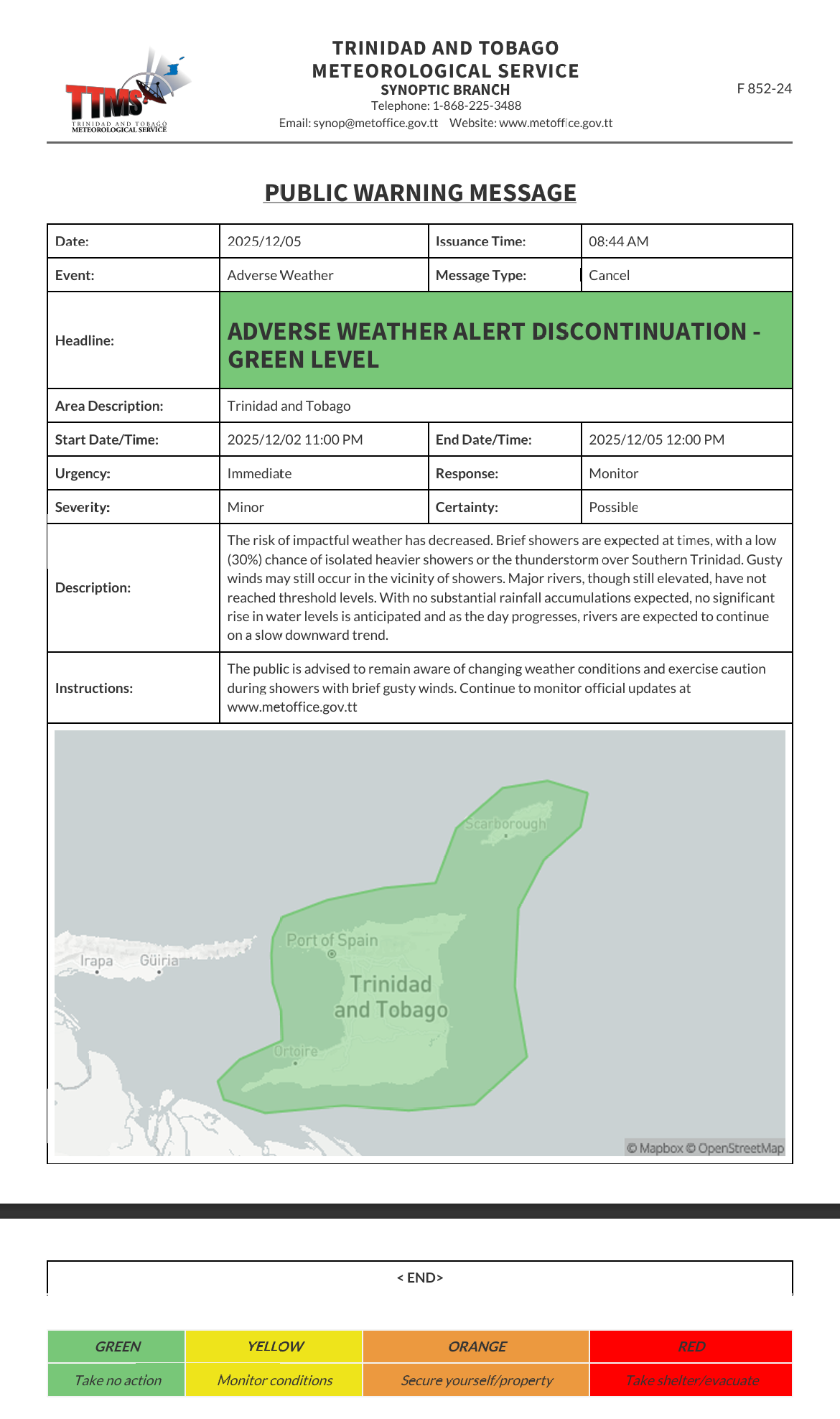
The TTMS states, “The risk of impactful weather has decreased. Brief showers are expected at times, with a low (30%) chance of isolated heavier showers or thunderstorms over Southern Trinidad. Gusty winds may still occur in the vicinity of showers. Major rivers, though still elevated, have not reached threshold levels. With no substantial rainfall accumulations expected, no significant rise in water levels is anticipated, and as the day progresses, rivers are expected to continue on a slow downward trend.”

The alert’s color indicates the event’s severity and the likelihood of its occurrence. Currently, the alert level is green. This alert status considers the possibility of the event ending, with certainty at its second-lowest level, at “possible,” and severity remains moderate. Discontinuations and green-level alerts have historically been issued with a likelihood of ‘very likely/observed’ or ‘likely’.
This means that additional hazards (street/flash flooding, gusty winds, landslides) are still possible; the impacts are minor for this particular alert.
The Met Office advises the public to remain aware of changing weather conditions and exercise caution during showers with brief gusty winds


