


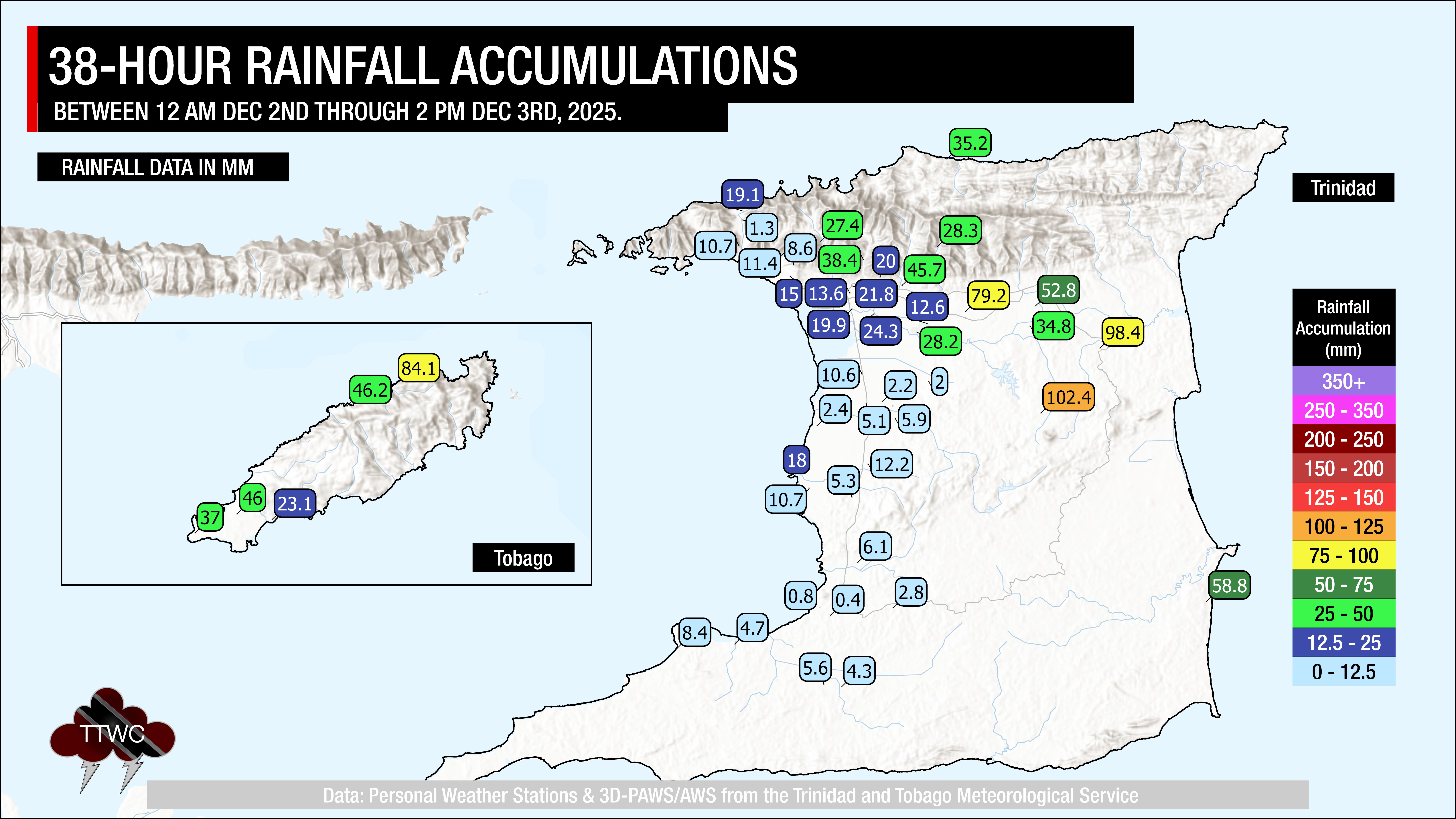
Over the last 12-18 hours, rainfall has primarily affected northern and eastern Trinidad and across Tobago, with flooding, fallen trees, and landslides reported. Additional rain is forecast through the next 24-28 hours across the country.
What you need to know
— What: A broad, deep-layered trough affecting the Windward Islands, including Trinidad and Tobago, through Thursday, coupled with deep, tropical moisture. In addition, larger-scale environmental factors are also favorable this week, leading to periods of rain, isolated to scattered showers, and thunderstorms.
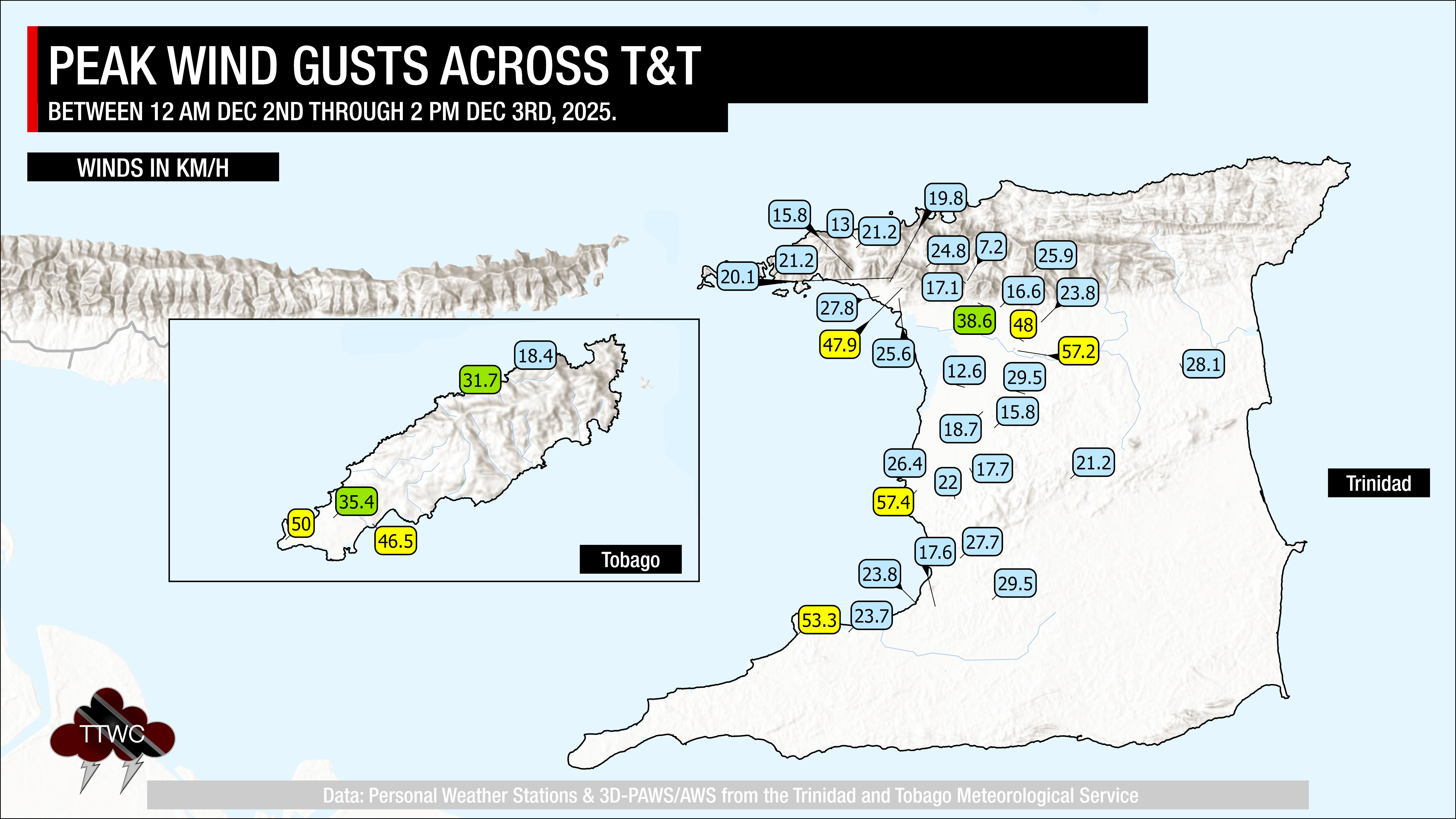
— Where: Through Thursday evening, both islands are forecast to experience isolated to scattered rainfall, with minimum rainfall totals ranging between 25 and 50 millimeters, favoring the western half of Trinidad. Higher rainfall totals are expected across the eastern half of Trinidad and across Tobago, with likely totals ranging from 50 to 75 millimeters and highly isolated totals peaking at 150 millimeters, favoring eastern coastal areas. Gusty winds (45-55 km/h) are likely, with higher gusts across Tobago and accompanying heavy showers/thunderstorms across both islands.
— When: The TTMS maintains the Adverse Weather Alert from 11:00 PM Tuesday, December 2nd, 2025, through 4:00 PM Thursday, December 4th, 2025. Conditions are forecast to settle by late Thursday as drier air moves in and upper-level conditions become less favorable into Friday.
— Impacts: Street/flash flooding and localized ponding are likely in heavy downpours, accompanied by gusty winds likely exceeding 45 km/h and gusts exceeding 55 km/h possible, favoring Tobago and areas that experience thunderstorms. These wind gusts, combined with heavy rainfall, may lead to fallen trees/utility poles/lines and landslides, as well as localized wind damage and agitated seas. Smaller watercourses may become overwhelmed by repeated rainfall, particularly tonight into Thursday across northeastern Trinidad.
— What Should You Do: Secure loose outdoor objects. Motorists and residents in areas prone to flooding or landslides should remain alert and exercise caution. Be aware of your surroundings and changing weather conditions. Take necessary precautions to mitigate potential impacts. If you encounter flood waters, turn around. If you hear thunder, head indoors. For those in flood-prone areas of northeastern Trinidad, review your flood safety plan if flood waters rapidly rise.
Latest Alerts

Localized Flood Alert Discontinued For Trinidad
Trinidad and Tobago is NOT under any tropical storm or hurricane threat, watch, or warning at this time.
The Adverse Weather Alert
The Trinidad and Tobago Meteorological Service has maintained the Adverse Weather Alert (Yellow Level) at 9:53 AM Wednesday, December 3rd, 2025. The alert went into effect at 11:00 AM Tuesday, December 2nd, 2025, and remains in effect through 4:00 PM Thursday, December 4th, 2025, for Trinidad and Tobago.
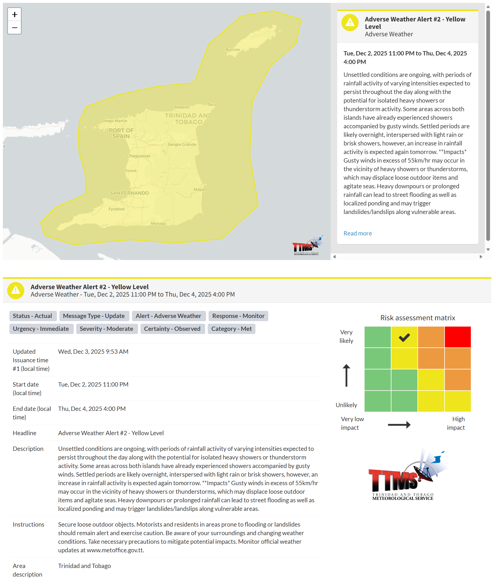
This adverse weather event has been observed, according to the TTMS:
- Unsettled conditions are ongoing, with periods of rainfall of varying intensity expected to persist throughout the day, along with the potential for isolated heavy showers or thunderstorms. Some areas across both islands have already experienced showers accompanied by gusty winds. Settled periods are likely overnight, interspersed with light rain or brisk showers; however, rainfall activity is expected to increase again tomorrow.
- Impacts: Gusty winds exceeding 55km/h may occur in the vicinity of heavy showers or thunderstorms, which may displace loose outdoor items and agitate seas. Heavy downpours or prolonged rainfall can lead to street flooding and localized ponding, and may trigger landslides/landslips in vulnerable areas.

The alert’s color indicates the event’s severity and the likelihood of its occurrence. Currently, the alert level is Yellow. This means the hazards are very likely and the impacts are moderate for this particular alert. You should be aware of the hazards in your area, which include street or flash flooding, gusty winds exceeding 45 km/h to 55 km/h, falling trees, landslides, and agitated seas.
A moderate Adverse Weather Alert can result in possible injuries and behavioral changes, which are necessary to ensure safety. Minor property damage may also occur, temporarily disrupting income-earning activities and affecting several communities.
The Met Office advises the public to secure loose outdoor objects. Motorists and residents in areas prone to flooding or landslides should remain alert and exercise caution. Be aware of your surroundings and changing weather conditions. Take necessary precautions to mitigate potential impacts. Monitor official weather updates.


