


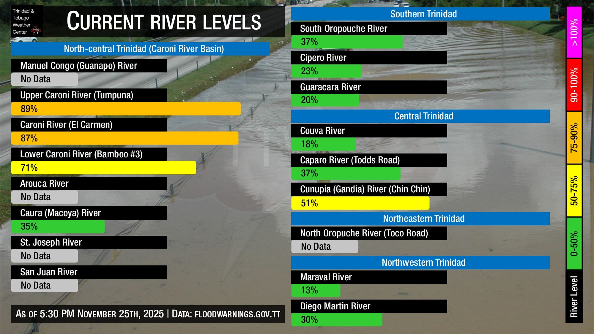
The Trinidad and Tobago Meteorological Service is explicitly forecasting the Caroni River to reach threshold levels this evening, with localized overspill possible in low-lying, flood-prone areas of the lower Caroni Basin.
What you need to know
— What: Elevated moisture moving across T&T and the Windwards associated with the ITCZ, surface to low-level confluence on the southern periphery of a ridge across the Atlantic, and weak low-level troughing producing unsettled weather across T&T on Tuesday, with unsettled weather likely through the week as upper-level conditions become more favorable. As a result, periods of rain, isolated to scattered showers, and thunderstorms are forecast through tonight.
— Where: On Tuesday, both islands are forecast to experience isolated to scattered rainfall, with minimum rainfall totals ranging between 15 and 25 millimeters and maximum totals up to 85 millimeters, favoring northern and eastern areas of Trinidad. Gusty winds (45-55 km/h) are likely, with higher gusts across Tobago and in heavy shower/thunderstorm activity across both islands.
— When: The TTMS maintains the Adverse Weather Alert from 5:00 AM Tuesday, November 25th, 2025, through 9:00 PM Tuesday, November 25th, 2025, capturing the most intense activity for Tuesday.
— Impacts: Street/flash flooding and localized ponding are likely in heavy downpours, accompanied by gusty winds likely exceeding 45 km/h and gusts exceeding 55 km/h possible, favoring Tobago. These wind gusts, combined with heavy rainfall, may lead to fallen trees/utility poles/lines and landslides, as well as localized wind damage and agitated seas. Localized, brief flooding is now expected along low-lying, flood-prone areas of the Caroni and possibly the North Oropouche River Basins.
— What Should You Do: Secure loose outdoor objects. Motorists and residents in areas prone to flooding or landslides should remain alert and exercise caution. Be aware of your surroundings and changing weather conditions. Take necessary precautions to mitigate potential impacts. If you encounter flood waters, turn around. If you hear thunder, head indoors.
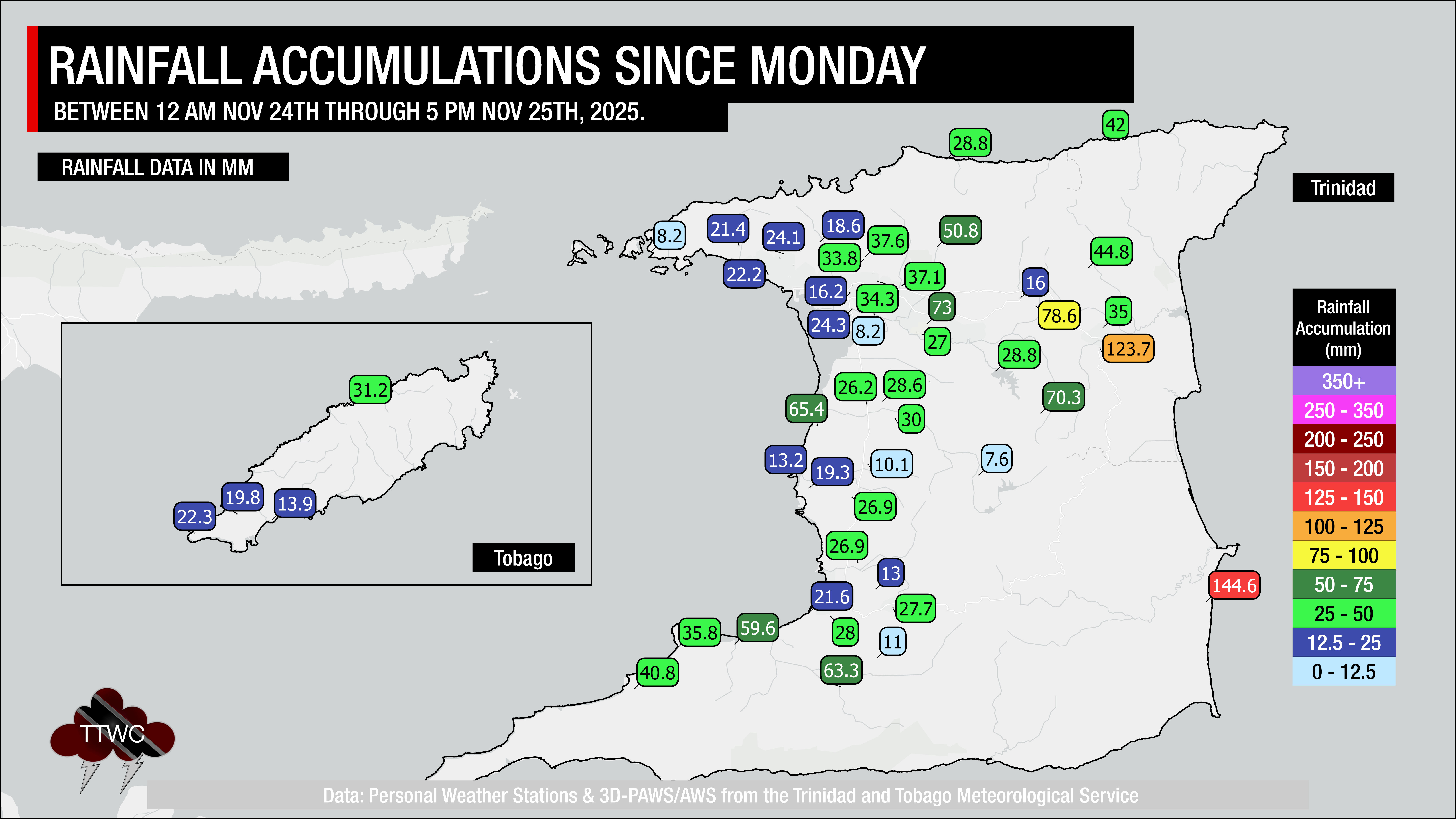
Since midnight Tuesday, between 15 and 35 millimeters have fallen across Trinidad, with parts of northern and northeastern Trinidad recording between 35 and 70 millimeters. Wind gusts exceeding 55 km/h were also recorded at Crown Point, Tobago, in heavy showers. As a result, the Caroni River is now nearing threshold levels across the Upper Caroni River Basin, and the Cunapo River – a tributary of the North Oropouche River, according to eyewitness reports – has already begun to flood adjacent low-lying areas as of 6:00 PM Tuesday.
Latest Alerts

Localized Flood Alert Discontinued For Trinidad
Trinidad and Tobago is NOT under any tropical storm or hurricane threat, watch, or warning at this time.
The Adverse Weather Alert
The Trinidad and Tobago Meteorological Service has updated the Adverse Weather Alert (Yellow Level) at 4:12 PM Tuesday, November 25th, 2025. The alert went into effect at 5:00 AM Tuesday, November 25th, 2025, and remains in effect through 9:00 PM Tuesday, November 25th, 2025, for Trinidad and Tobago.
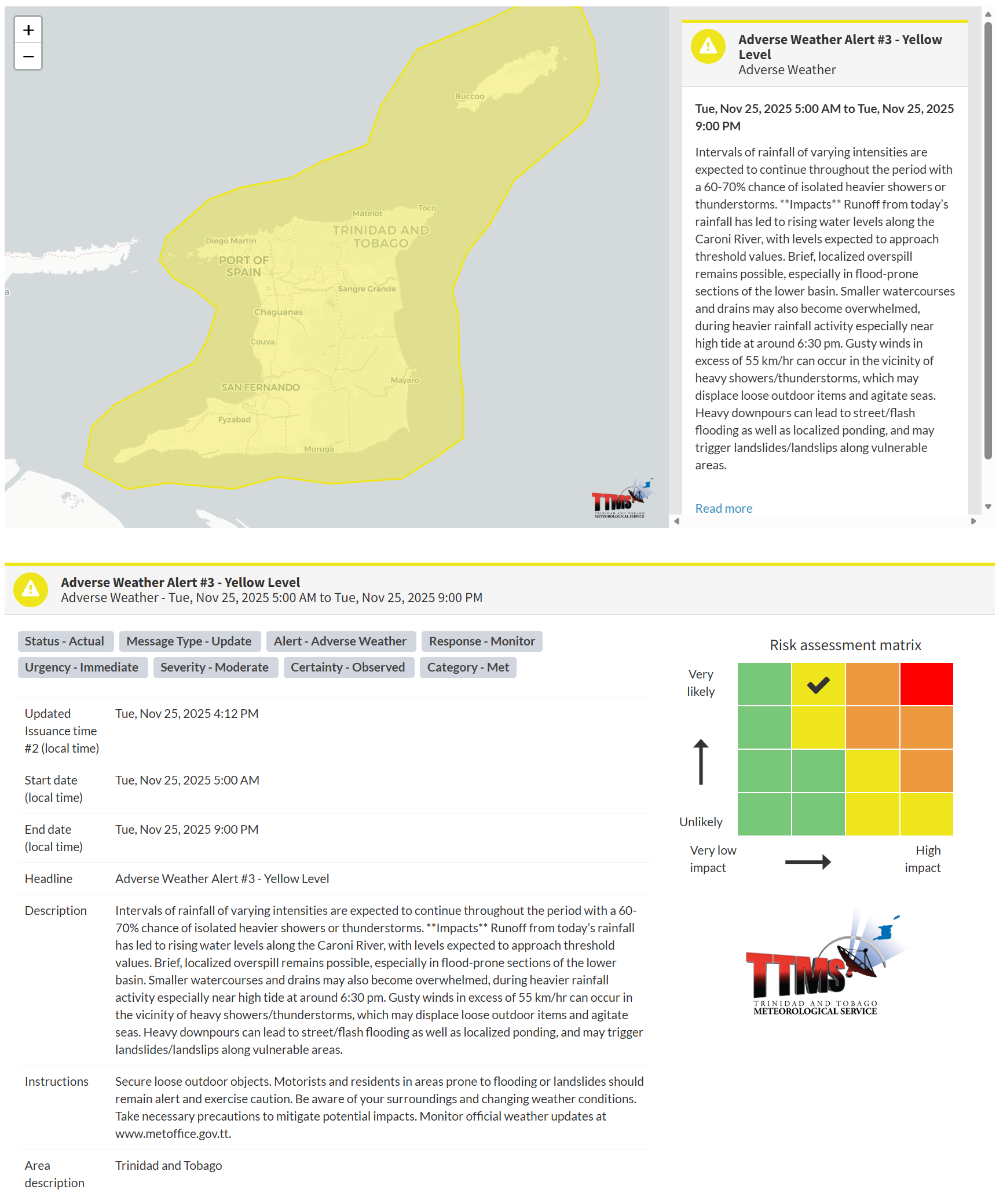
This adverse weather event is very likely, according to the TTMS:
- Intervals of rainfall of varying intensities are expected to continue throughout the period, with a 60-70% chance of isolated heavier showers or thunderstorms.
- Impacts: Runoff from today’s rainfall has led to rising water levels along the Caroni River, with levels expected to approach threshold values. Brief, localized overspill remains possible, especially in flood-prone sections of the lower basin. Smaller watercourses and drains may also become overwhelmed during heavier rainfall activity, especially near high tide at around 6:30 pm.
- Impacts: Gusty winds in excess of 55 km/hr can occur in the vicinity of heavy showers/thunderstorms, which may displace loose outdoor items and agitate seas. Heavy downpours can lead to street/flash flooding as well as localized ponding, and may trigger landslides/landslips along vulnerable areas.

The alert’s color indicates the event’s severity and the likelihood of its occurrence. Currently, the alert level is Yellow. This means the hazards are very likely and the impacts are moderate for this particular alert. You should be aware of the hazards in your area, which include street or flash flooding, gusty winds exceeding 45 km/h to 55 km/h, falling trees, landslides, and agitated seas. Riverine flooding is now possible across the Caroni, North Oropouche, and Ortoire River Basins, given rainfall totals over the past 41 hours and ongoing rainfall.
A moderate Adverse Weather Alert can result in possible injuries and behavioral changes, which are necessary to ensure safety. Minor property damage may also occur, temporarily disrupting income-earning activities and affecting several communities.
The Met Office advises the public to secure loose outdoor objects. Motorists and residents in areas prone to flooding or landslides should remain alert and exercise caution. Be aware of your surroundings and changing weather conditions. Take necessary precautions to mitigate potential impacts. Monitor official weather updates.


