


What you need to know
— What: Elevated moisture moving in across T&T and the Windwards associated with the ITCZ, surface to low-level confluence on the southern periphery of a ridge across the Atlantic, and weak low-level troughing is forecast to produce unsettled weather across T&T on Tuesday, with unsettled weather likely through the week as upper-level conditions become more favorable. As a result, periods of rain, isolated to scattered showers, and thunderstorms are forecast.
— Where: On Tuesday, both islands are forecast to experience isolated to scattered rainfall, with minimum rainfall totals ranging between 15 and 25 millimeters and maximum totals up to 85 millimeters, favoring southern and eastern areas of Trinidad. Gusty winds (45-55 km/h) are possible, with higher gusts across Tobago and in heavy shower/thunderstorm activity across both islands.
— When: The TTMS has issued the Adverse Weather Alert from 5:00 AM Tuesday, November 25th, 2025, through 9:00 PM Tuesday, November 25th, 2025, capturing the most intense activity for Tuesday.
— Impacts: Street/flash flooding and localized ponding are likely in heavy downpours, accompanied by gusty winds likely exceeding 45 km/h and gusts exceeding 55 km/h possible. These wind gusts, combined with heavy rainfall, may lead to fallen trees/utility poles/lines and landslides, as well as localized wind damage and agitated seas.
— What Should You Do: Secure loose outdoor objects. Motorists and residents in areas prone to flooding or landslides should remain alert and exercise caution. Be aware of your surroundings and changing weather conditions. Take necessary precautions to mitigate potential impacts. If you encounter flood waters, turn around. If you hear thunder, head indoors.
Latest Alerts

Localized Flood Alert Discontinued For Trinidad
Trinidad and Tobago is NOT under any tropical storm or hurricane threat, watch, or warning at this time.
The Adverse Weather Alert
The Trinidad and Tobago Meteorological Service has issued an Adverse Weather Alert (Yellow Level) at 4:04 PM Monday, November 24th, 2025. The alert goes into effect at 5:00 AM Tuesday, November 25th, 2025, through 9:00 PM Tuesday, November 25th, 2025 for Trinidad and Tobago.
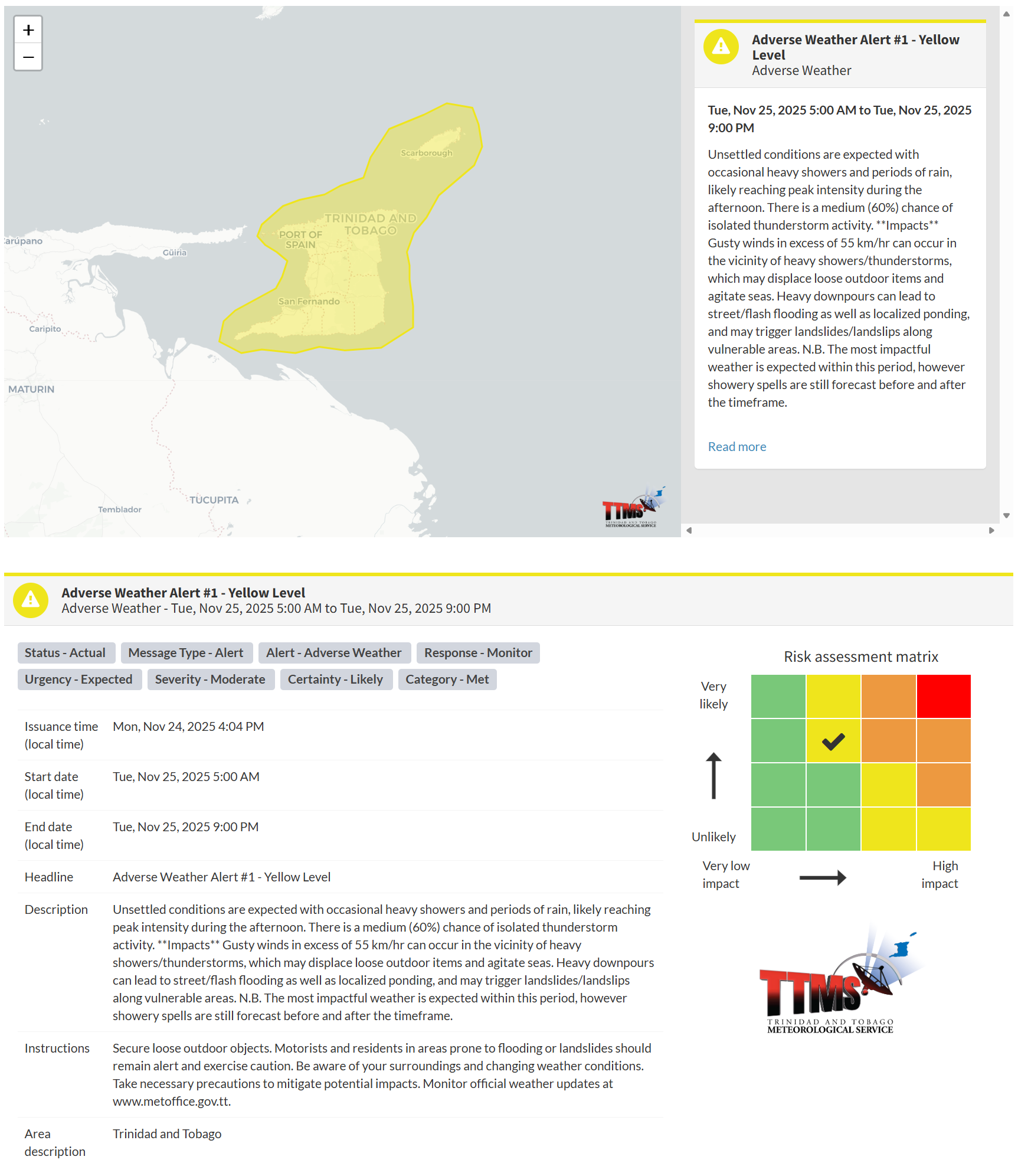
This adverse weather event is likely, according to the TTMS:
- Unsettled conditions are expected, with occasional heavy showers and periods of rain, likely peaking in the afternoon. There is a medium (60%) chance of isolated thunderstorm activity.
- Impacts: Gusty winds in excess of 55 km/hr can occur in the vicinity of heavy showers/thunderstorms, which may displace loose outdoor items and agitate seas. Heavy downpours can lead to street/flash flooding as well as localized ponding, and may trigger landslides/landslips along vulnerable areas.
- The most impactful weather is expected within this period; however, showery spells are still forecast before and after the timeframe.

The alert’s color indicates the event’s severity and the likelihood of its occurrence. Currently, the alert level is Yellow. This means the hazards are likely and the impacts are moderate for this particular alert. You should be aware of the hazards in your area, which include street or flash flooding, gusty winds exceeding 45 km/h to 55 km/h, falling trees, landslides, and agitated seas.
A moderate Adverse Weather Alert can result in possible injuries and behavioral changes, which are necessary to ensure safety. Minor property damage may also occur, temporarily disrupting income-earning activities and affecting several communities.
The Met Office advises the public to secure loose outdoor objects. Motorists and residents in areas prone to flooding or landslides should remain alert and exercise caution. Be aware of your surroundings and changing weather conditions. Take necessary precautions to mitigate potential impacts. Monitor official weather updates.


