


What you need to know
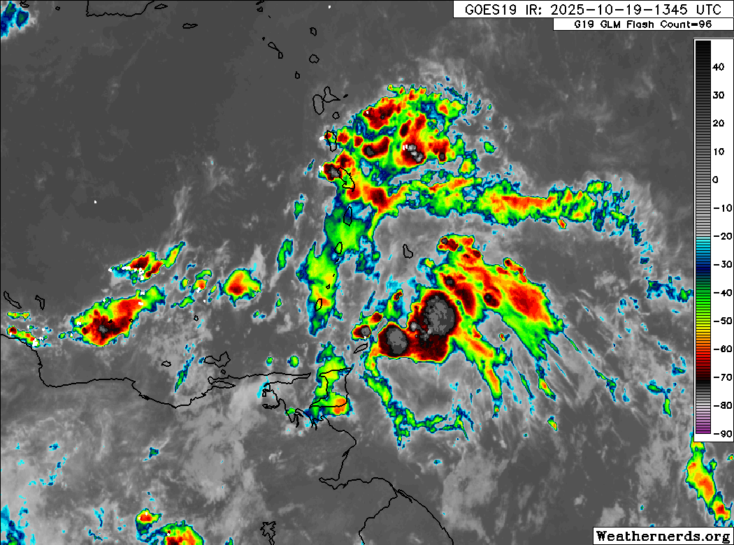
— What: A tropical wave (TW44/Invest 98L), the Intertropical Convergence Zone, and a combination of favorable upper- and low-level conditions, deep-layered moisture, and light wind shear are forecast to lead to periods of rain, showers, and thunderstorms, some of which may be locally heavy/strong, particularly on Sunday into Monday.
— Where: Both islands are forecast to experience locally high rainfall totals through Tuesday. Latest forecasts show up to 75 millimeters across both islands, with localized totals up to 125 millimeters across parts of Trinidad, particularly across eastern areas of both islands. Gusty winds (45-55 km/h) are likely on Sunday through Monday, with higher gusts across Tobago and in heavy shower/thunderstorm activity across both islands.
— When: The TTMS has issued the Adverse Weather Alert from noon Saturday, October 18th, 2025, through 10:00 PM Monday, October 20th, 2025, capturing the most intense activity.
— Impacts: Street/flash flooding and localized ponding are likely in heavy downpours, accompanied by gusty winds exceeding 45 km/h. These wind gusts, combined with heavy rainfall, may lead to fallen trees/utility poles/lines and landslides, as well as localized wind damage and agitated seas. In strong thunderstorm activity, frequent lightning is likely, with the possibility of funnel clouds on Sunday into Monday. By Sunday night, as soils become saturated, those living in flood-prone areas along larger watercourses should be aware of the possibility of flash or riverine flooding.
— What Should You Do: Secure loose outdoor objects. Motorists and residents in areas prone to flooding or landslides should remain alert and exercise caution. Be aware of your surroundings and changing weather conditions. Take necessary precautions to mitigate potential impacts. If you encounter flood waters, turn around. If you hear thunder, head indoors.
Latest Alerts

Localized Flood Alert Discontinued For Trinidad
Trinidad and Tobago is NOT under any tropical storm or hurricane threat, watch, or warning at this time.
The Adverse Weather Alert
The Trinidad and Tobago Meteorological Service updated the Adverse Weather Alert (Yellow Level) on Sunday, October 19th, 2025, at 2:47 PM. The alert went into effect at noon (12:00 PM) Saturday, October 18th, 2025, and remains in effect for Trinidad, Tobago, and surrounding waters, through 10:00 PM Monday, October 20th, 2025.
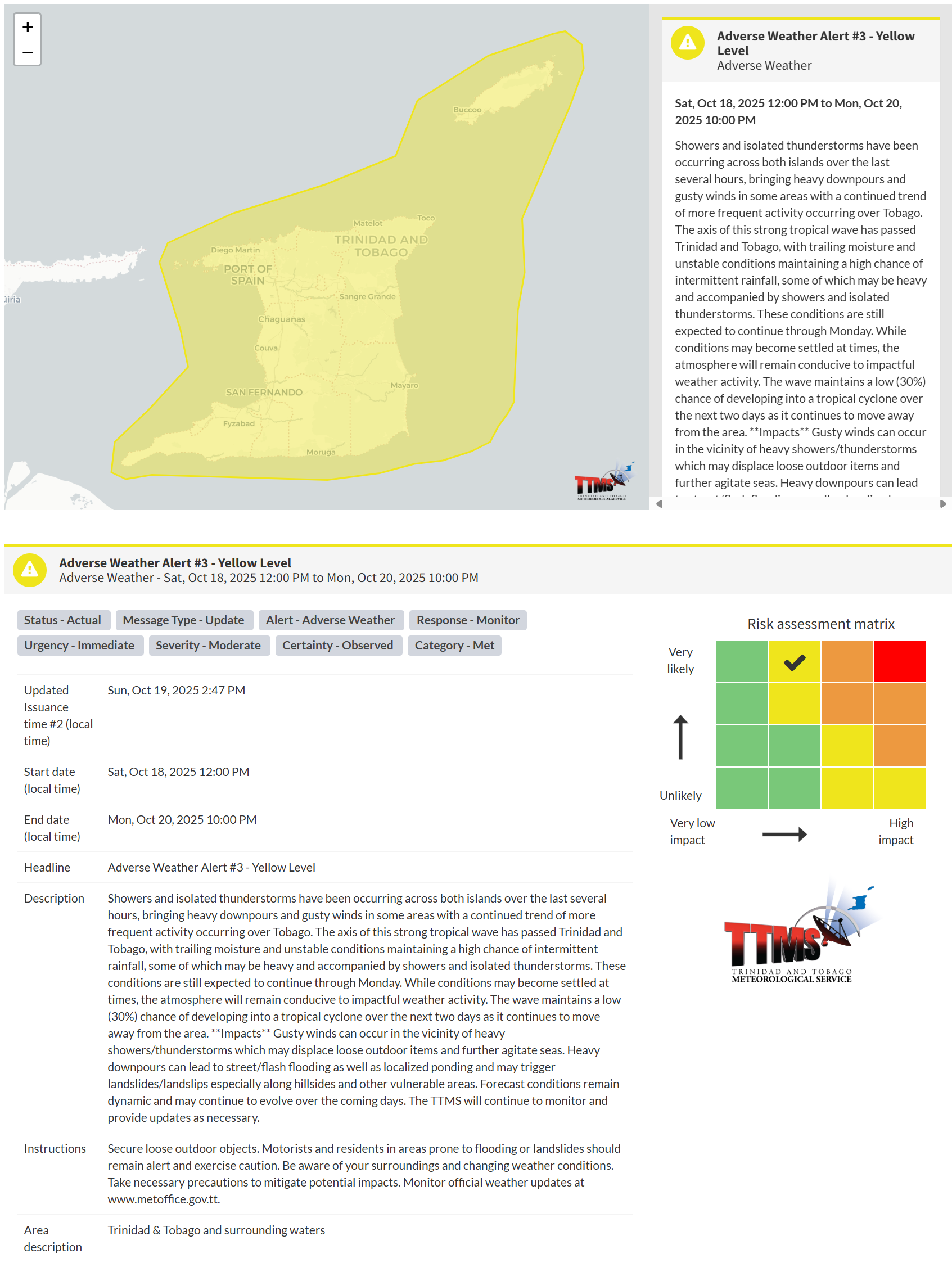
According to the TTMS, this “alert” status considers the possibility of the event occurring. This adverse weather event has been observed, and the following are very likely, according to the TTMS:
- Showers and isolated thunderstorms have been occurring across both islands over the last several hours, bringing heavy downpours and gusty winds in some areas with a continued trend of more frequent activity occurring over Tobago.
- The axis of this strong tropical wave has passed Trinidad and Tobago, with trailing moisture and unstable conditions maintaining a high chance of intermittent rainfall, some of which may be heavy and accompanied by showers and isolated thunderstorms.
- These conditions are still expected to continue through Monday. While conditions may become settled at times, the atmosphere will remain conducive to impactful weather activity. The wave maintains a low (30%) chance of developing into a tropical cyclone over the next two days as it continues to move away from the area.
- Impacts: Gusty winds can occur in the vicinity of heavy showers/thunderstorms, which may displace loose outdoor items and further agitate seas. Heavy downpours can lead to street/flash flooding as well as localized ponding and may trigger landslides/landslips, especially along hillsides and other vulnerable areas.
- Forecast conditions remain dynamic and may continue to evolve over the coming days. The TTMS will continue to monitor and provide updates as necessary.

The alert’s color indicates the event’s severity and the likelihood of its occurrence. Currently, the alert level is Yellow. This means the hazards are very likely, and the severity of the impacts is moderate for this particular alert. You should be aware of the hazards in your area, which include street or flash flooding, gusty winds exceeding 45 km/h, falling trees, landslides, and agitated seas.
A moderate Adverse Weather Alert can result in possible injuries and behavioral changes, which are necessary to ensure safety. Minor property damage may also occur, temporarily disrupting income-earning activities and affecting several communities.
The Met Office advises the public to secure loose outdoor objects. Motorists and residents in areas prone to flooding or landslides should remain alert and exercise caution. Be aware of your surroundings and changing weather conditions. Take necessary precautions to mitigate potential impacts.


