What you need to know
— What: Long-period swells up to 15 seconds, producing large, breaking waves, have decreased to periods up to 12 seconds. In addition, spring tides through October 24th will enhance wave heights during high tide. Lastly, winds in heavy showers/thunderstorms are likely to lead to locally choppy/rough seas.
— Where: Impactful swells predominantly impacted T&T’s northern and northeastern coastlines.
— When: Swell periods between 12-13 seconds are forecast to continue through Sunday morning. Another swell event is forecast from mid-Monday into Tuesday with peak swells up to 15 seconds.
— Impacts: Though the alert has been discontinued, agitated seas with exacerbated conditions at high tides, larger-than-normal breakers with large, battering waves in the surf zone; disruption of near-shore activities, including fishing, swimming, and boat moorings; coastal flooding with intrusion of salt water, and displacement of sand, further than the average reach point, and elevated risk of rip currents, particularly along northern and eastern beaches.
— What Should You Do: Although the alert was discontinued, all marine interests need to exercise extreme caution. Inexperienced mariners should avoid navigating in hazardous conditions, especially those operating smaller vessels. If you intend to go into the water, it is recommended that you use beaches with on-duty lifeguards.
Latest Alerts

Localized Flood Alert Discontinued For Trinidad
Trinidad and Tobago is NOT under any tropical storm or hurricane threat, watch, or warning at this time.
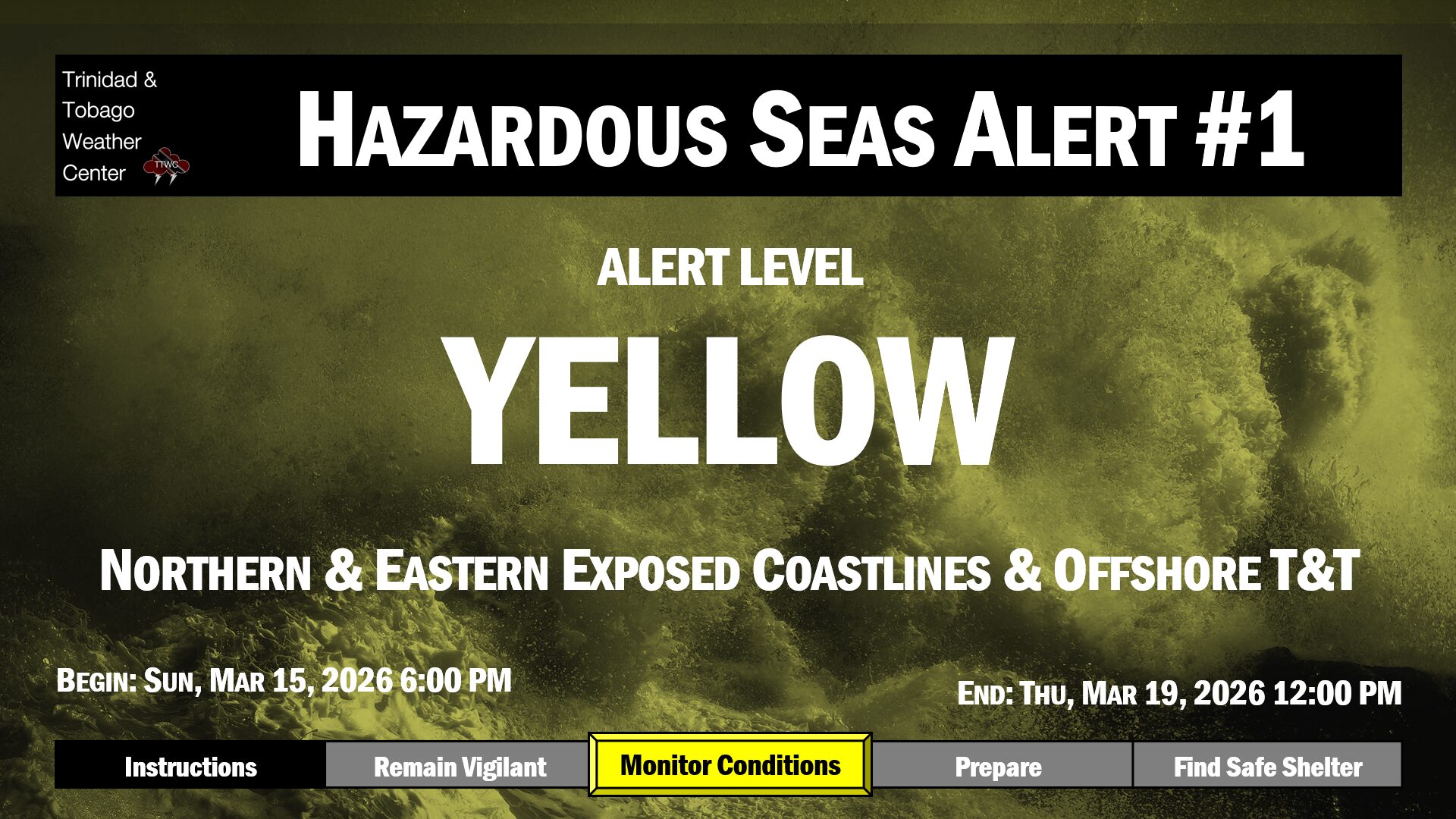
The Hazardous Seas Alert
The Trinidad and Tobago Meteorological Service has discontinued the Hazardous Seas Alert for the coastal areas of northern Tobago, northeastern Tobago, and, to a lesser extent, northern Trinidad at 3:42 PM Saturday, October 18th, 2025. Forecast models indicate long-period swells are forecast to continue through Sunday morning, with another short-lived swell event Monday into Tuesday.
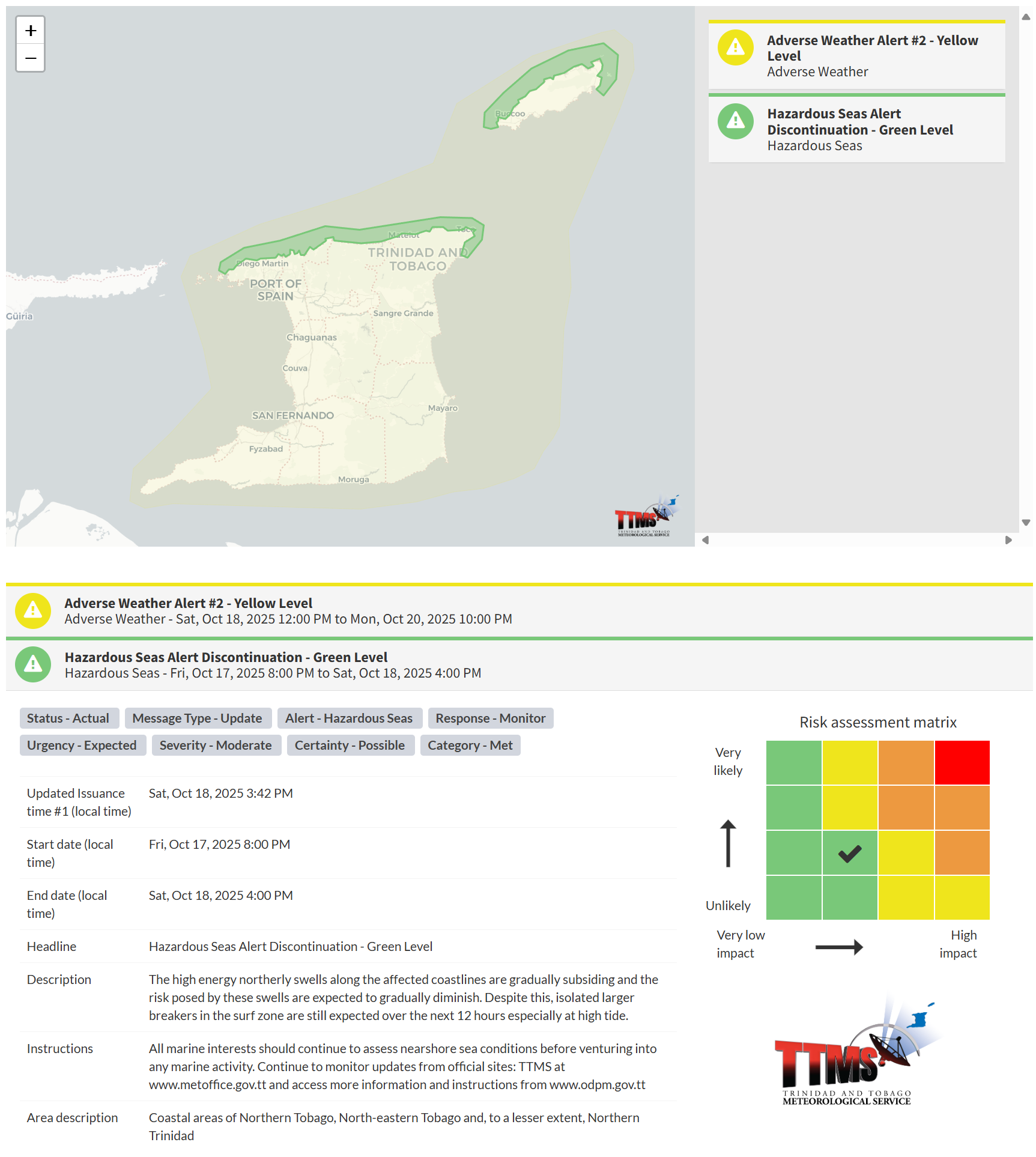
“The high-energy northerly swells along the affected coastlines are gradually subsiding, and the risk posed by these swells is expected to gradually diminish. Despite this, isolated larger breakers in the surf zone are still expected over the next 12 hours, especially at high tide,” according to the Trinidad and Tobago Meteorological Service.

The alert’s color indicates the event’s severity and the likelihood of its occurrence. Currently, the alert level is green. Although the alert has been discontinued, based on the risk matrix, the hazards remain possible and the impacts are moderate.
There is an increased risk of strong rip currents, which pose a serious hazard to swimmers and beachgoers. Rip currents can be life-threatening even for experienced swimmers. Agitated seas will likely be particularly dangerous for offshore activities, including fishing and other small craft marine interests.
For a moderate Hazardous Seas Alert, there is potential for injuries, requiring behavioral changes to ensure safety. There may be minor property damage, income-earning temporarily disrupted, and a couple of communities affected.
The Met Office advises that all marine interests should continue to assess nearshore sea conditions before venturing into any marine activity.