Warning: preg_match(): Unknown modifier '0' in /home/ttweathercenteradmin/htdocs/ttweathercenter.com/wp-content/plugins/powerkit/modules/lazyload/helpers/helper-powerkit-lazyload.php on line 151
A rare tornado struck Westmoorings North just after midday on October 7th, 2025, lofting galvanized sheets across the upscale community in northwestern Trinidad, leading to multiple reports of roof and structural damage. Electricity was cut off to approximately 200 homes in the area, and there were no reports of injuries, though many residents were at home when the tornado struck.
How did the tornado form?
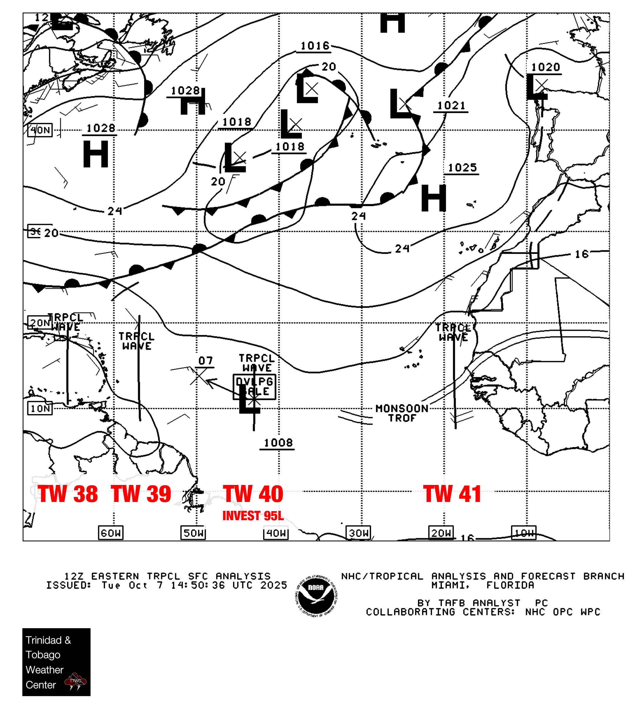
Trinidad and Tobago was sandwiched between two tropical waves – Tropical Wave 38, which moved across the region on October 6th, and Tropical Wave 39 (analyzed by the Trinidad and Tobago Meteorological Service as a low-level trough) to T&T’s east. Both of these features, combined with the Intertropical Convergence Zone, resulted in an environment characterized by light winds and high atmospheric moisture.
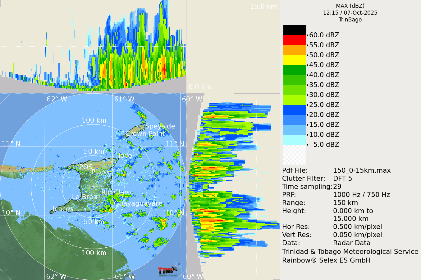
The trigger for Tuesday’s thunderstorms, which spawned a tornado, was a combination of another low-level trough moving across T&T, strong daytime heating, and sea-breeze convergence, where moist air from the Gulf of Paria collided with prevailing winds from the east. However, we see this combination of atmospheric events nearly every day during the Wet Season, yet tornadoes remain a relatively rare phenomenon in T&T.
Tornado formation is not entirely understood, and there are two main ways a tornado may form. In the case of the 2025 Westmoorings Tornado, the following mechanism is the likely explanation for how this tornado formed.
Firstly, a horizontal spinning effect must form on the Earth’s surface. This usually originates in sudden changes in wind direction or speed, known as wind shear. Secondly, a thundercloud, or occasionally a cumulus cloud, must be present.
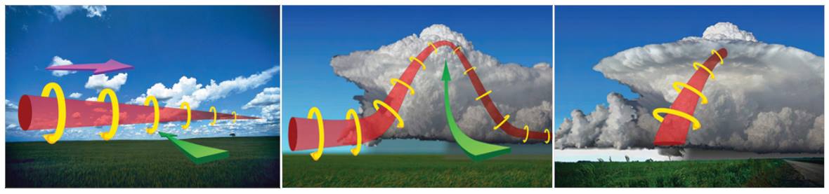
During a thunderstorm, updrafts are occasionally powerful enough to lift the horizontal spinning row of air upwards, turning it into a vertical air column. This vertical air column then becomes the basic structure for the tornado. Tornadoes that form in this way are often weak and generally last less than 10 minutes, which was the case on Tuesday.
After a thorough review of eyewitness accounts, photos, and videos, unlike most of the tornadoes that have formed across Trinidad and Tobago over the past decade, this tornado initially formed over the Gulf of Paria, southeast of Westmoorings.
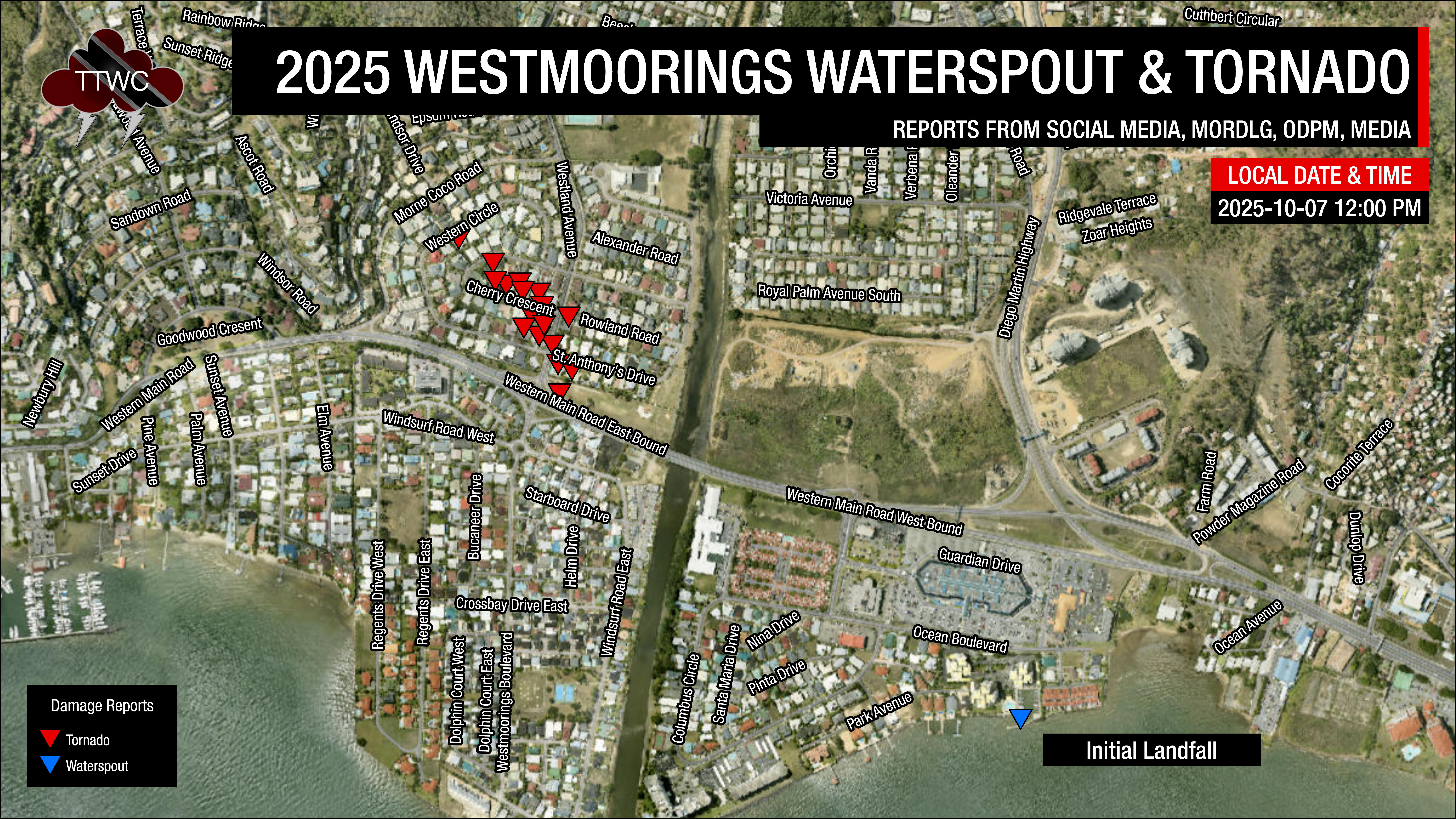
The 2025 Westmoorings Tornado initially formed as a waterspout south of the Towers, located just south of The Falls at West Mall. However, the surface winds quickly weakened once the waterspout moved onshore.
There were no damage reports between where the waterspout made landfall at the Towers and where the first report of damage came in, shortly after midday, along the Western Main Road near Riverside Park.
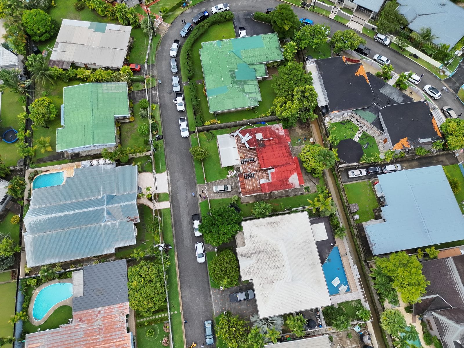
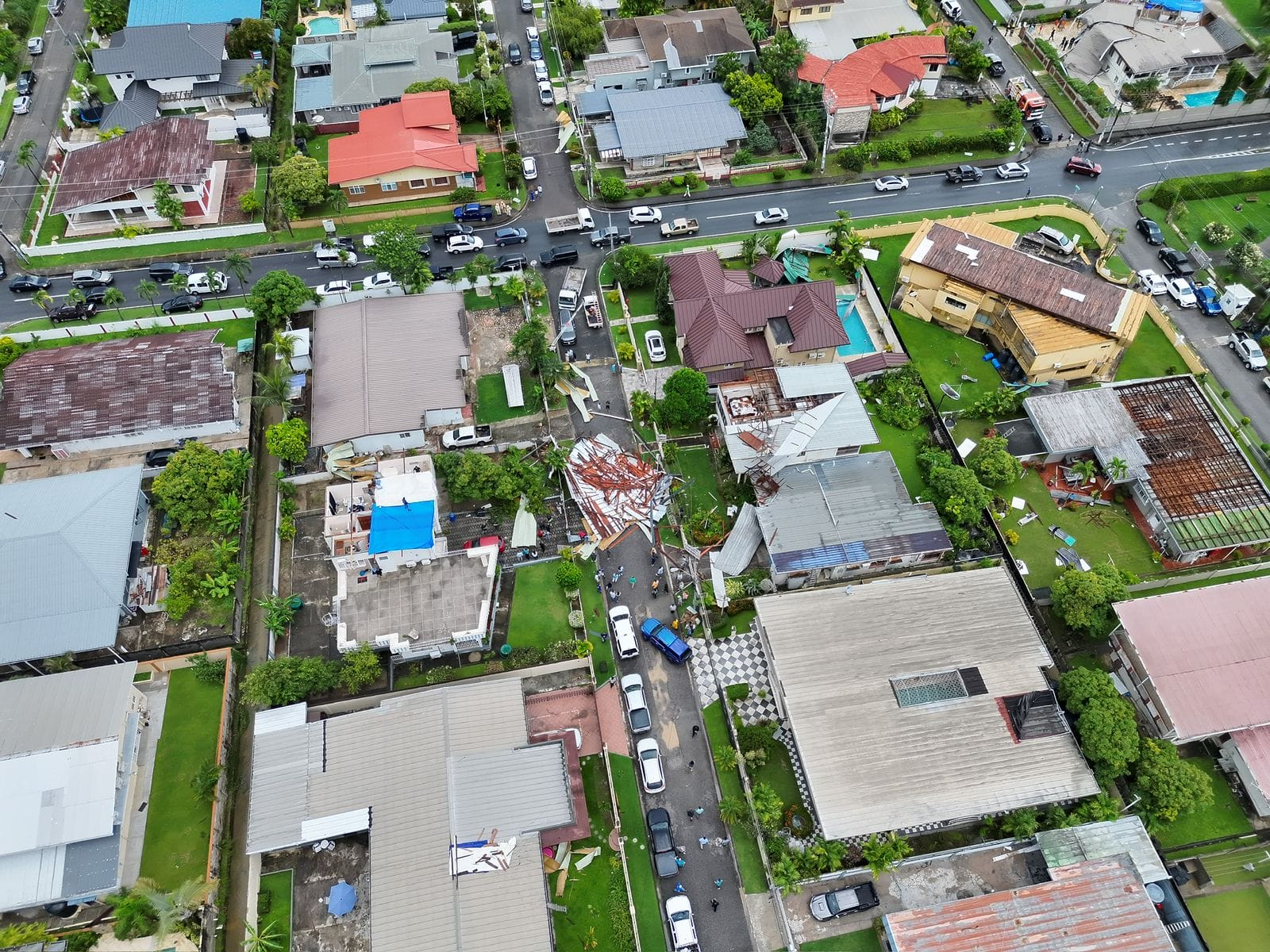
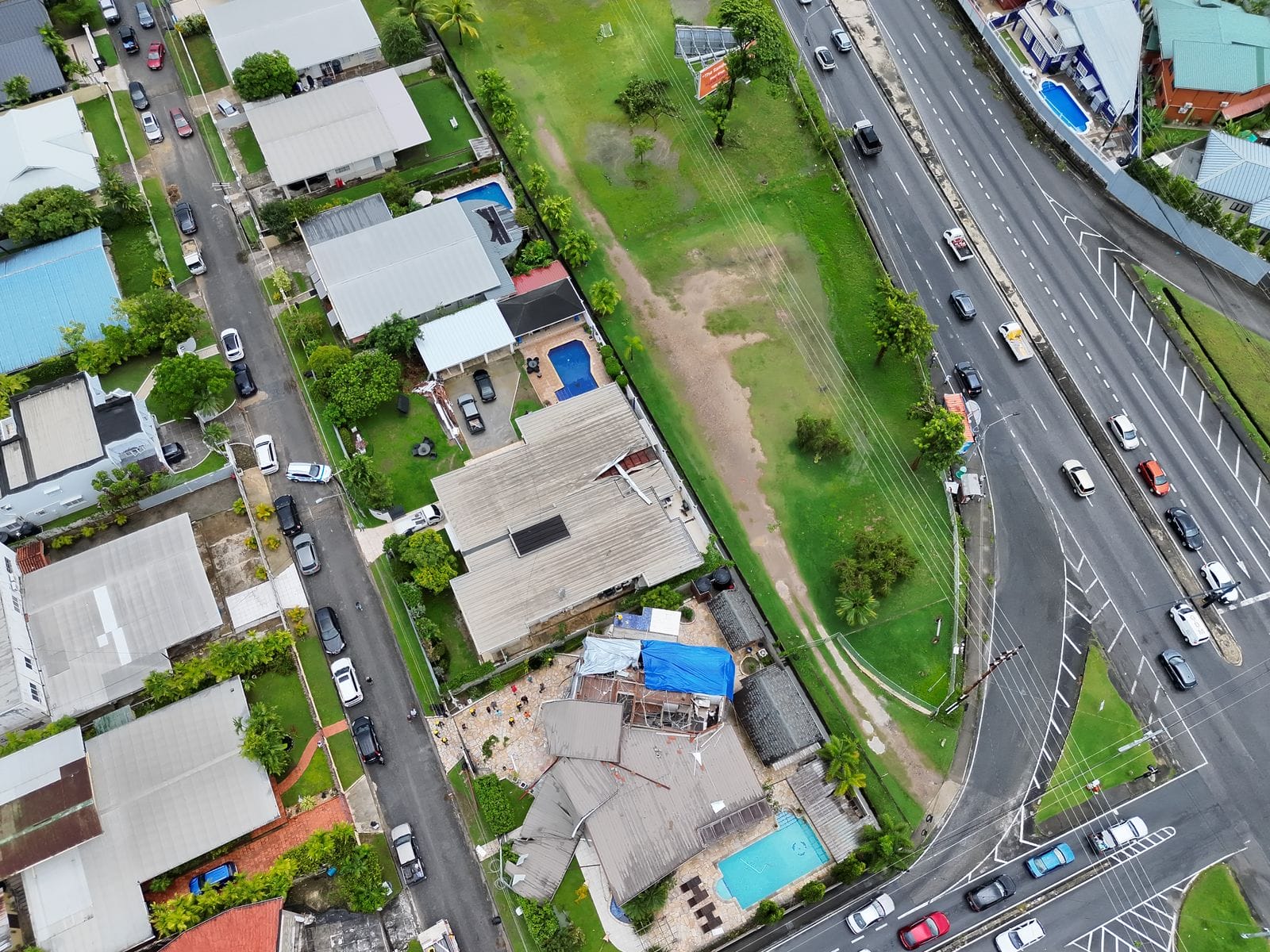
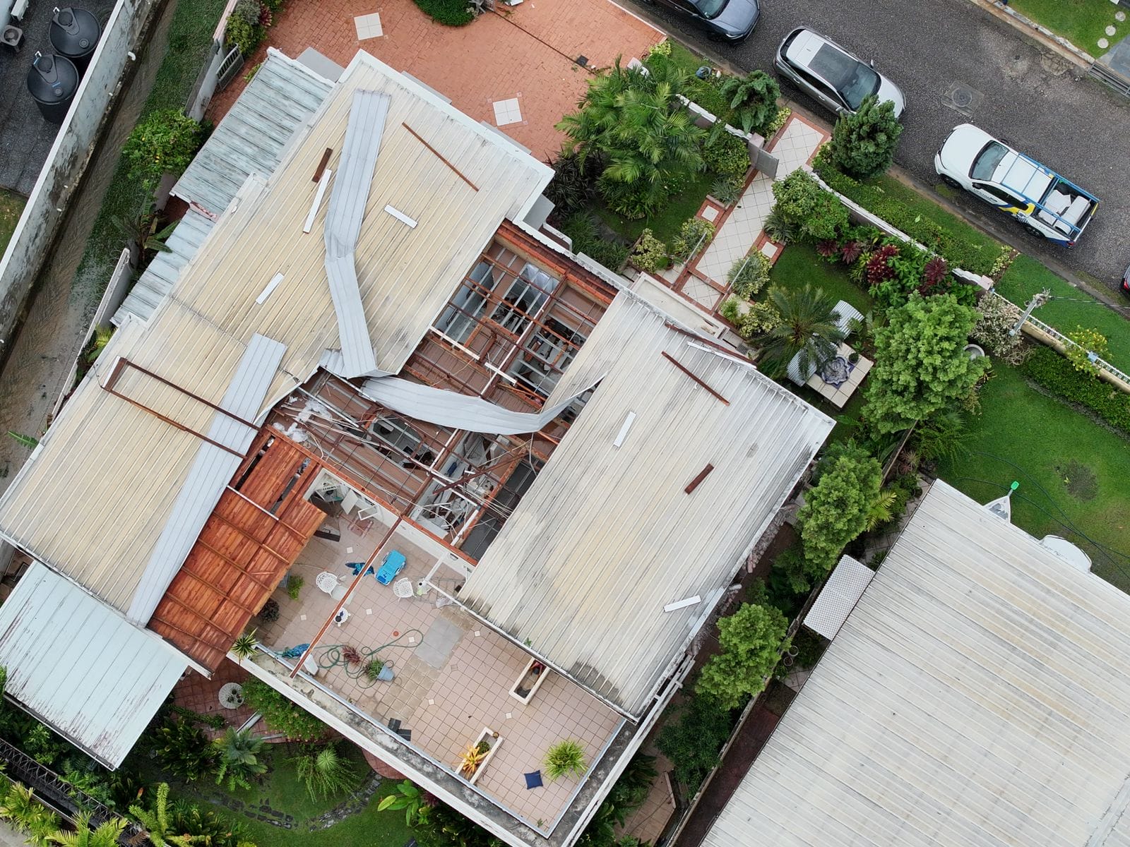
The tornado first hit a bus shed along the eastbound lanes of the Western Main Road as it began its path of destruction into Westmoorings North, ripping off a roof at the corner of St. Anthony’s Drive and Westland Road shortly after midday.
It continued moving northwest, ripping off roofs primarily on Cherry Crescent South and lofting galvanized sheets high into the atmosphere. The tornado lasted approximately 3-5 minutes in Westmoorings, with the last of the damage occurring at Western Circle.
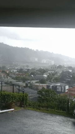
With weak tornadoes, often the rotating column of air makes it to the surface with little to no condensation funnels typically associated with tornadoes – making them even more dangerous if you’re relying on seeing that funnel to determine the tornado’s motion. Videos captured small vortices that appeared for just a few seconds, where the most intense wind damage occurred.
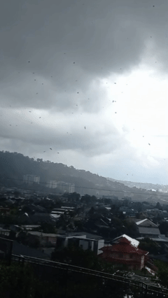
The first vortex was briefly visible on the left side of the video, developing over a house on Cherry Crescent, where the roof was partially ripped off seconds later.
The second vortex developed over a house on Western Circle, also partially ripping off the roof of that house.

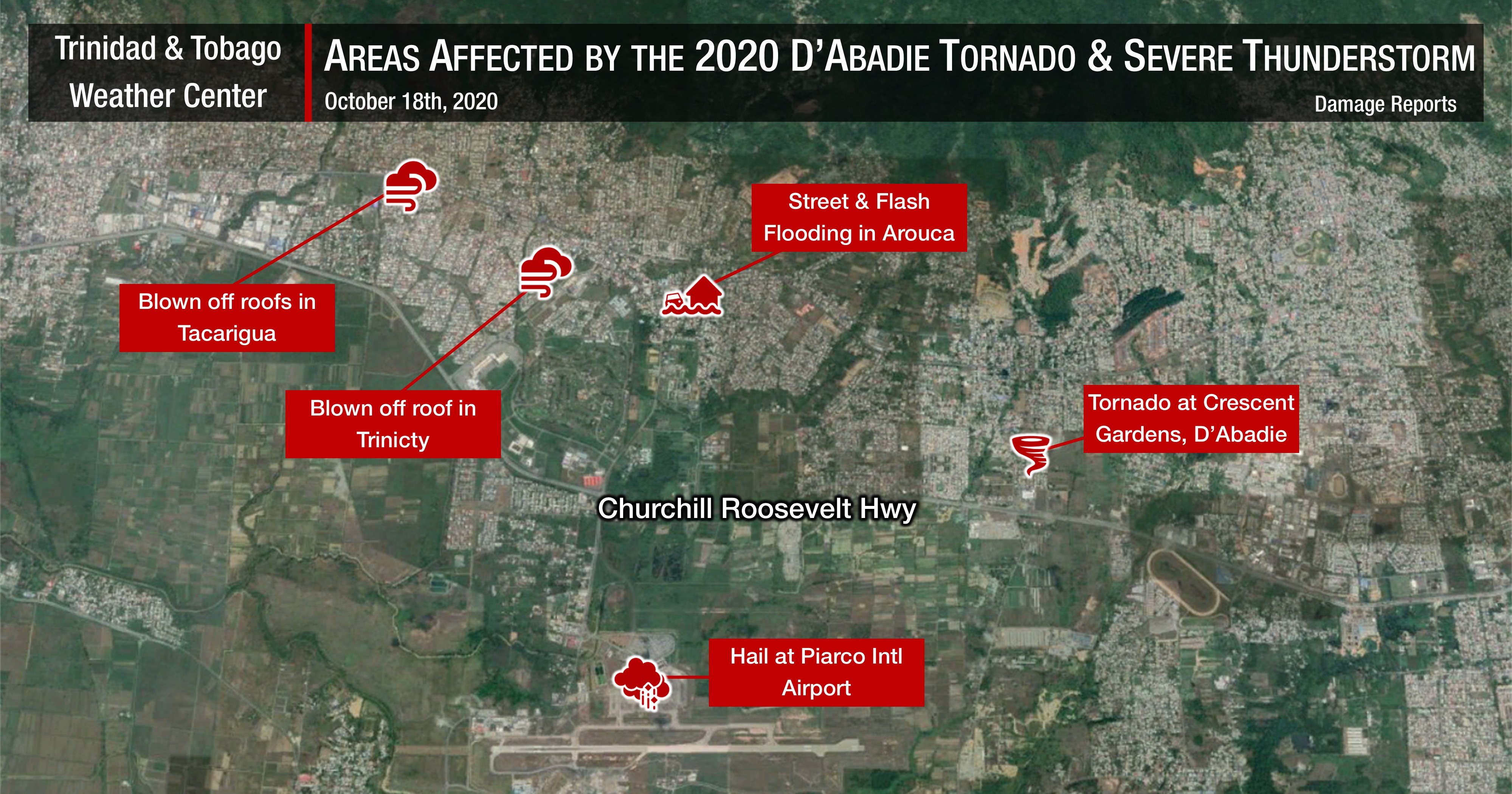
The Aftermath
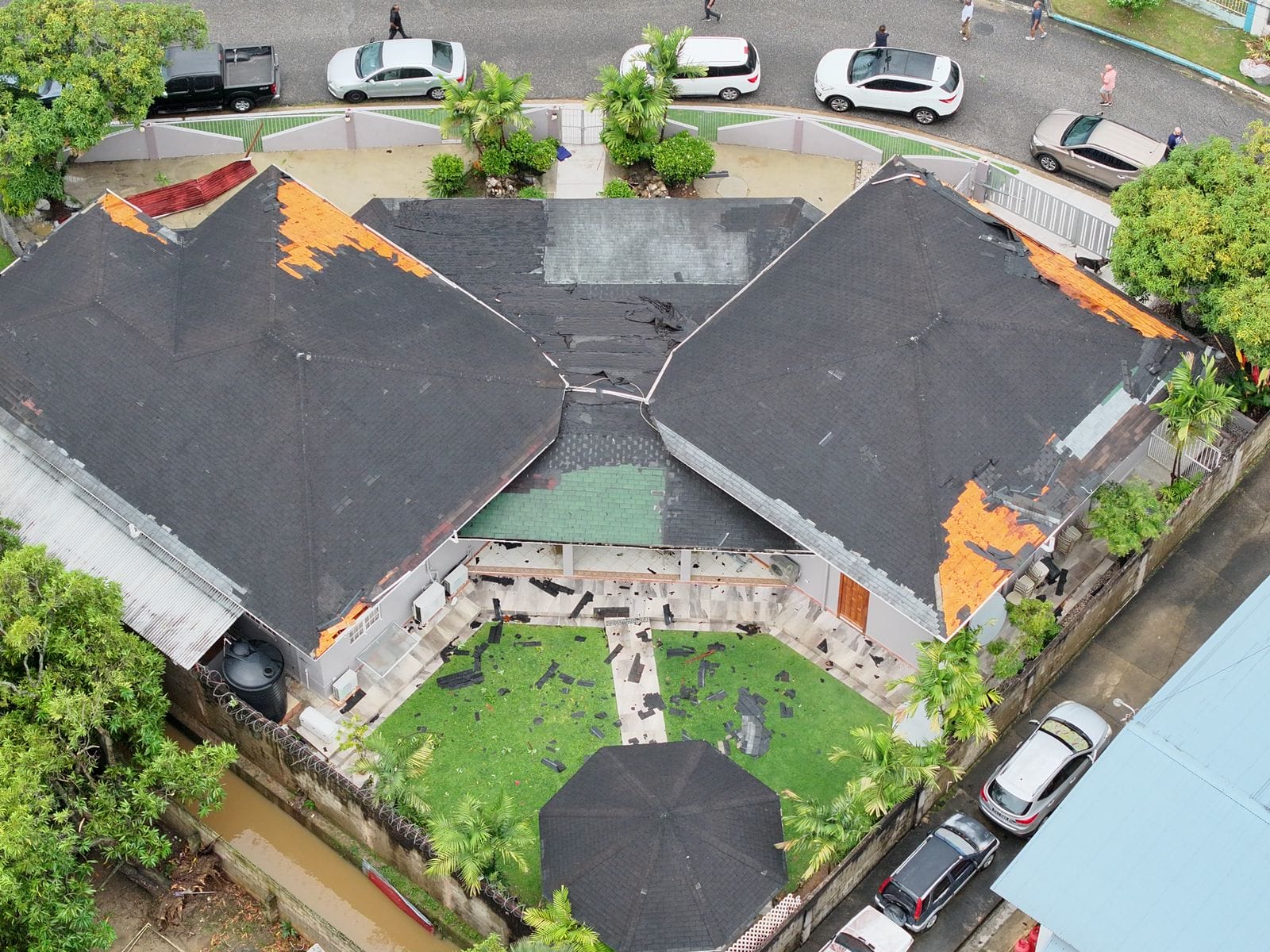
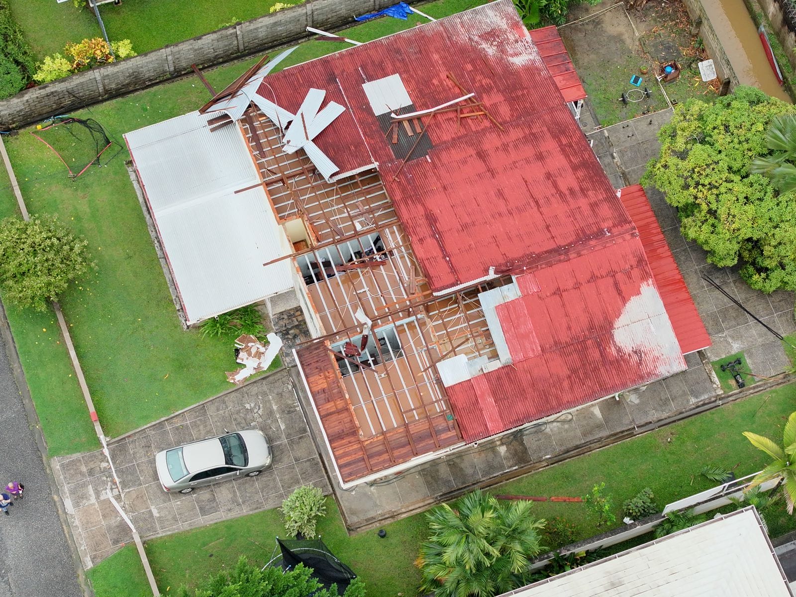
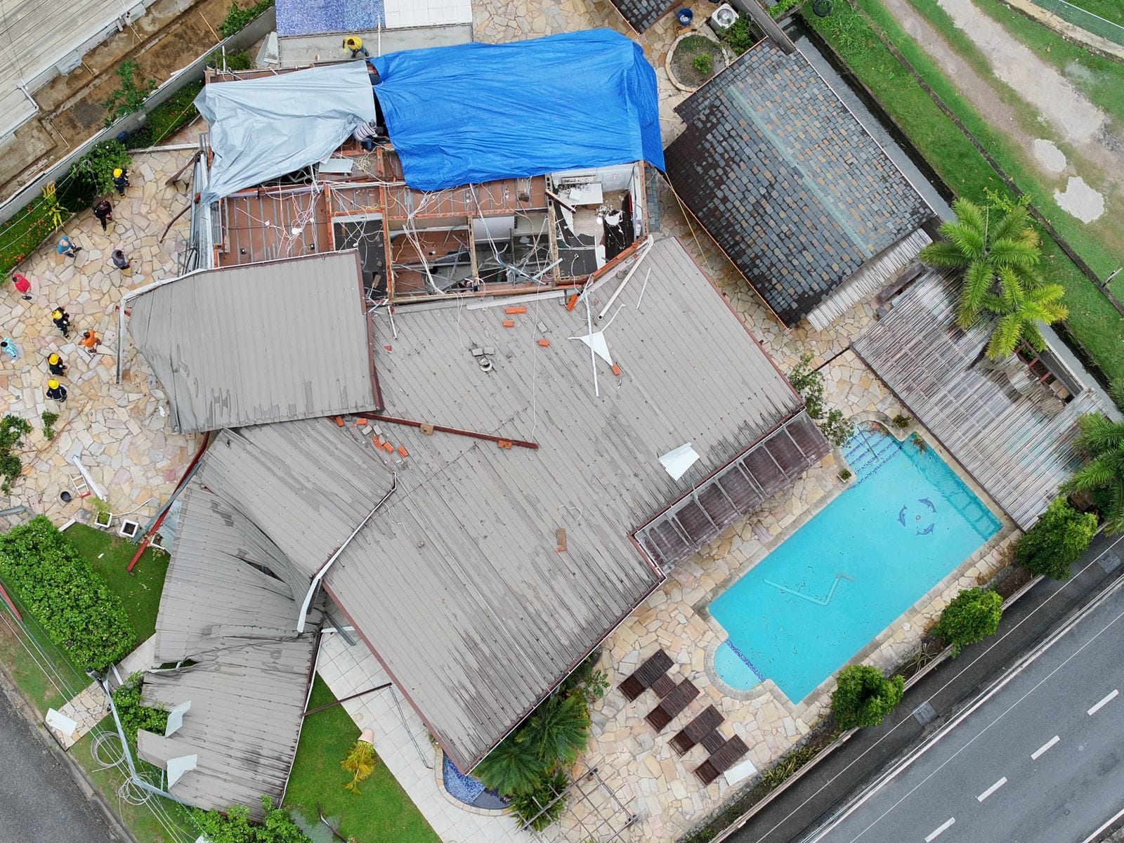
According to the Ministry of Rural Development and Local Government, 12 roofs were damaged and 16 homes were affected. As galvanized sheets were thrown across Westmoorings North, several power lines were damaged or destroyed, and electricity was shut off for nearly 200 homes until late Tuesday night.
Minister of Rural Development and Local Government Khadijah Ameen confirmed, “T&TEC initially shut off electricity in the entire area. They have now been able to isolate the affected streets, and electricity has been restored to the main. Even areas as far as Morne Coco and others that were affected have now had their electricity restored. What we are also doing is, together with the fire services, visiting each household to advise people if it’s safe to turn on electricity. Because they lost their entire roof, some of them, the entire structure is soaked. So even if they want to turn on electricity to use a power washer, for example, or to close their gate, which might be electronic, it may not be advisable to do so.”
In the United States and Canada, tornadoes are generally rated on a damage-based scale known as the Enhanced Fujita Scale, although other regions have different tornado scales. This scale uses the damage (or lack thereof) to rate the wind speeds of the tornado after the event.
In Trinidad, our previous tornadoes have been weak, generally ranking as EF-0. With an EF-0 tornado, three-second wind gusts between 105 km/h and 137 km/h occur. Damage typical for this scale of tornado includes peeled-off roofs, damage to gutters or siding, branches broken off trees, and shallow-rooted trees pushed over.
For a tornado to be considered EF-1, with three-second wind gusts of 138 km/h to 177 km/h, damage to temporary structures becomes significant, and cars and other vehicles may be pushed off the road or flipped. In an EF-1 tornado, permanent structures can sustain significant roof damage.
In the case of the 2025 Westmoorings Tornado, it lasted generally three to five minutes, with localized damage to the Westmoorings area, primarily affecting both secured and unsecured roofing, which peeled off galvanized sheets in some cases. Based on this damage, it is likely an EF-0 tornado. Although some homes (permanent structures) suffered major roof damage, no cars were flipped, and no trees were uprooted.
Severe Weather Elsewhere
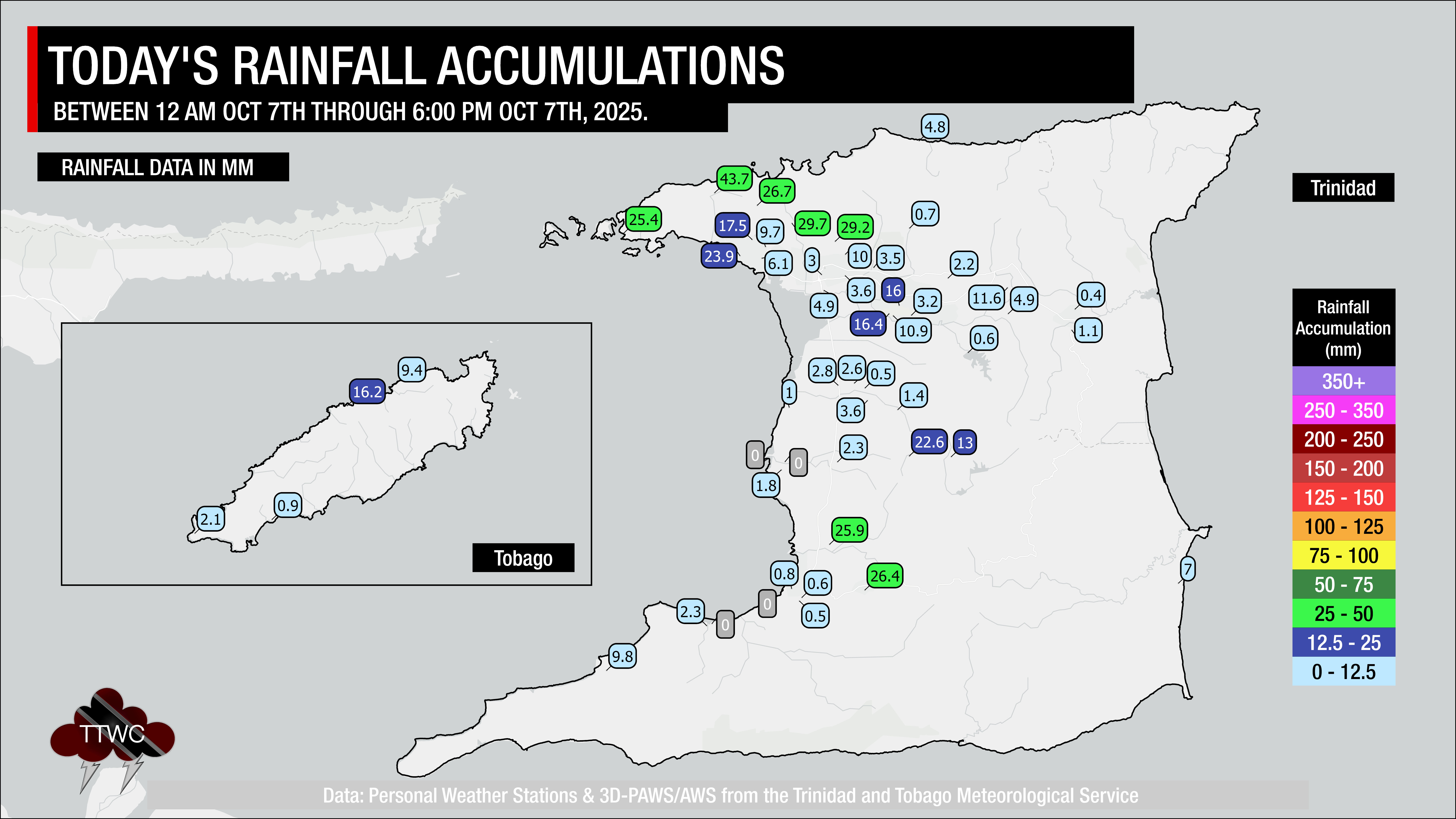
Heavy showers and thunderstorms produced localized street and flash flooding across parts of northern and southern Trinidad, with localized rainfall totals of 20 to 55 millimeters.
In northwestern Trinidad, where the strongest thunderstorms of the day occurred, street flooding was reported along the Western Main Road, Carenage; Ariapita Avenue, Woodbrook; and Morne Coco Road, Petit Valley. The Cuesa River overtopped at Tucker Valley Road, Carenage, rendering the roadway temporarily impassable to all vehicles.
On the North Coast Road, small trees were downed between the Pillars and Maracas Bay. At Maracas Bay, the North Coast Road and the parking lot were completely inundated due to a combination of heavy rainfall and higher-than-usual tides, which slowed runoff.
Meanwhile, across Williamsville, Ben Lomond, Reform, and Harmony Hall, minor street flooding occurred on the Guaracara Tabaquite Road.
Another Funnel?
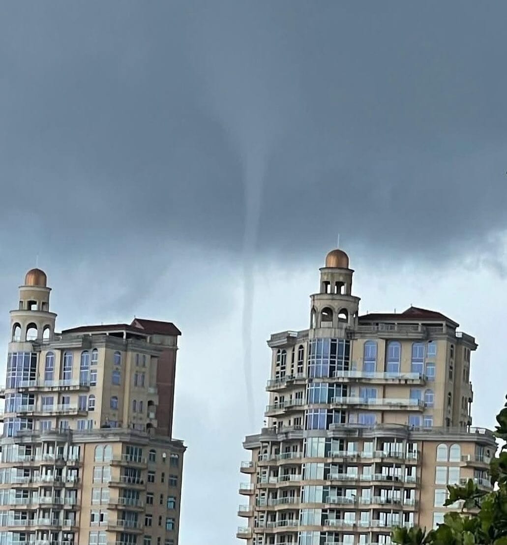
While it is difficult to say for sure, after the images and videos of the initial waterspout and tornadoes surfaced, this image of a funnel cloud appeared relatively southwest of where the Westmoorings tornado moved. We received no confirmation of this funnel touching down, so it is unclear if this was a new funnel or a waterspout.
Tornadoes and Trinidad
It is not certain how frequently the country experiences a tornado, as there really has been no good (or at least public) record-keeping of tornado events across Trinidad and Tobago. Until 2019, the country experienced a confirmed tornado once every decade, with the 2009 Caroni Plains tornado and then the 2019 Cunupia Tornado; the pattern held.
However, since 2019, the country has recorded six confirmed tornado events: the 2019 Cunupia and Port of Spain tornadoes, the 2020 Chase Village and D’Abadie tornadoes, the 2021 Los Iros Tornado, and the 2023 Woodland Tornado (July 29th, 2023), with yesterday’s tornado being the seventh.
Generally, these events occur during July through October, when the country experiences light winds, high atmospheric moisture, and a favorable wind profile through the atmosphere. This allows thunderstorms to develop a rotating updraft that extends to the ground. This setup generally occurs following the passage of tropical cyclones north of the country or with tropical waves.
It’s even more difficult to ascertain what exactly was a tornado versus the more common straight-line winds across Trinidad. Media reports and the general public usually attribute major wind damage to “twister-like” or “tornado-like” events.
Nine times out of ten, wind damage across Trinidad and Tobago can be attributed to gusty winds from thunderstorms or straight-line winds.
However, we’re trying to build a database of these events by scouring media reports dating back to the early 1900s to determine how frequently they occur and where they have occurred in the past.
There is no conclusive evidence to suggest that these tornadic events are linked to climate change at this time. Climatologists have already linked climate change to an increase in the frequency of stronger, localized showers and thunderstorms affecting Trinidad. However, the widespread use of camera phones and the internet has vastly improved the reporting of inclement weather, allowing us to capture reports of funnel clouds, waterspouts, and tornadoes as they occur. Still, a warmer atmosphere allows for more instability and stronger daytime heating, leading to stronger thunderstorms that potentially produce tornadic events during the afternoon.
Tornadoes across Trinidad and Tobago remain a very rare feature, but due to a lack of technology to issue and disseminate timely warnings to the public, it is imperative that you know what to do in the event of one occurring.