


While no major hazardous marine events are forecast over the next seven days, marine interests, particularly small craft operators, will need to exercise caution during heavy showers and thunderstorms due to occasional choppy seas, particularly early next week as a possible strong tropical wave moves across T&T.
Latest Alerts

Adverse Weather Alert Discontinued, Moderate Impacts Still Possible
Trinidad and Tobago is NOT under any tropical storm or hurricane threat, watch, or warning at this time.
Seas Forecast For Trinidad and Tobago
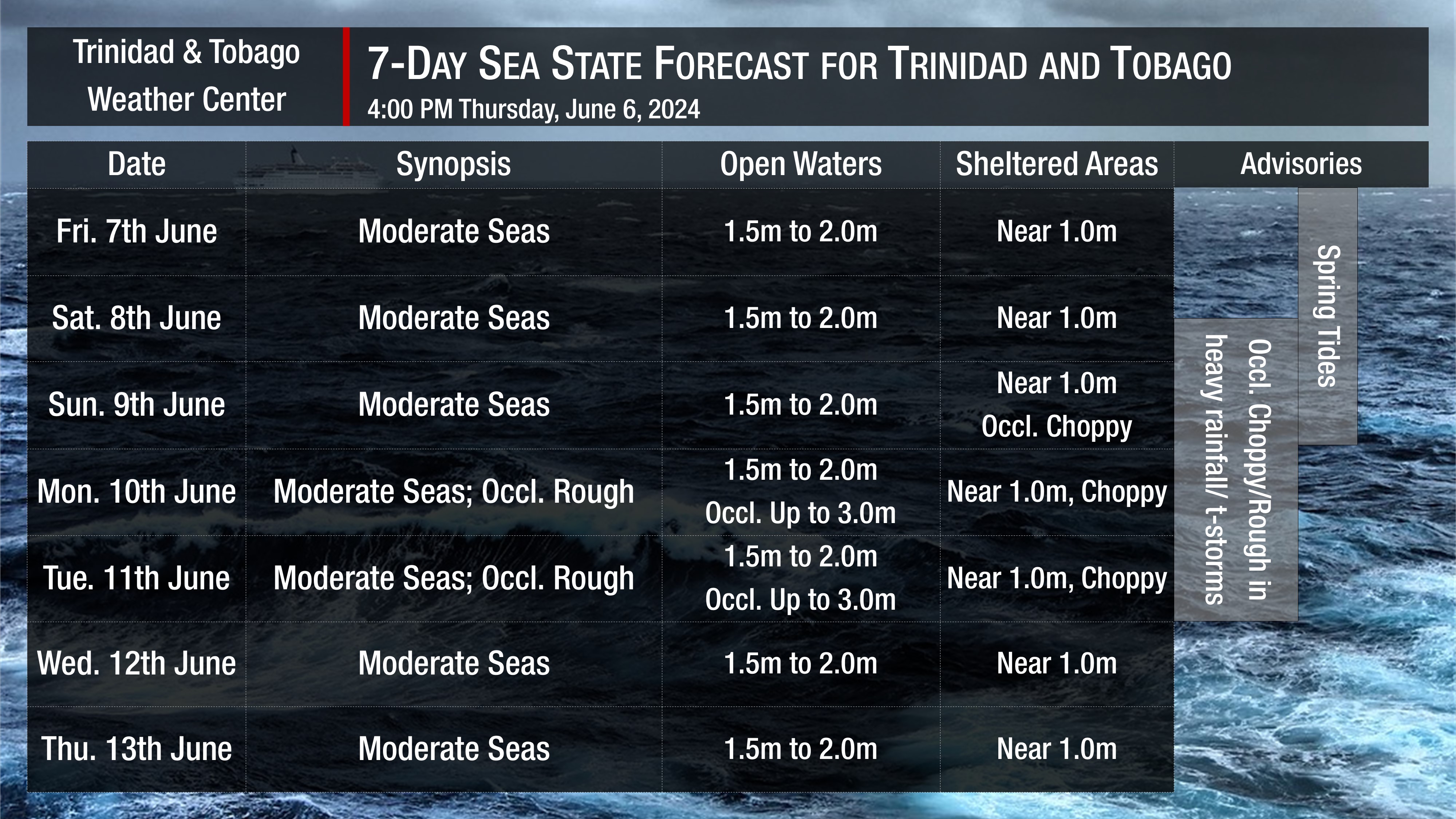
Through Saturday: Seas are forecast to be moderate in open waters, with waves up to 2.0 meters. In sheltered areas, waves are forecast to be near 1 meter, but conditions may become locally rough and/or choppy in the vicinity of heavy showers or thunderstorms, particularly on Saturday afternoon. Generally, winds are forecast to range from 10 knots to 15 knots, from the east to southeast, gusting to 20 knots, mainly in the vicinity of showers or thunderstorms. Swell periods are forecast to range between 7 and 10 seconds. Mild Saharan Dust concentrations are present. Spring tides ongoing.
Sunday: Seas are forecast to be moderate in open waters, with waves up to 2.0 meters. In sheltered areas, waves are forecast to be up to 1 meter, but choppy conditions are likely in heavy showers and thunderstorms. Swell periods are forecast to range between 7 and 10 seconds. During the early morning, winds from the southeast to northeast are forecast to range from 10 to 20 knots, gusting higher in showers and thunderstorms, but that direction changes from the mid-morning through the remainder of the day, from the east to south, with lighter winds between 5 and 15 knots, gusting to 25 knots in heavy showers and thunderstorms. Spring Tides end.
Monday through Tuesday: Forecast models indicate a possible strong tropical wave moving across T&T during this time. As a result, there is some difference in the forecast wind speeds across the area, which in turn affects sea conditions. Keep an eye on the latest forecasts for possible changes for these two days. However, generally, during this two-day period, moderate seas are forecast in open waters, with waves up to 2.0 meters, but occasional waves up to 3.0 meters are possible, particularly across Tobago’s eastern waters. In sheltered areas, waves are forecast to be up to 1 meter and choppy. Winds are forecast to be from the east to northeast during the first half of Monday, between 10 and 15 knots, but during the second half of the day into Tuesday, winds are forecast to be from the south to east, between 15 and 25 knots, with gusts to 30 knots. Swell periods are forecast to range between 7 and 10 seconds.
Wednesday through Thursday: Seas are forecast to be moderate in open waters, with waves up to 2.0 meters. In sheltered areas, waves are forecast to be below 1.0 meter. Swell periods are forecast to range between 6 and 10 seconds. Winds are forecast to range between 10 and 20 knots from the east-northeast to east-southeast, gusting to 25 knots.
Possible Impacts
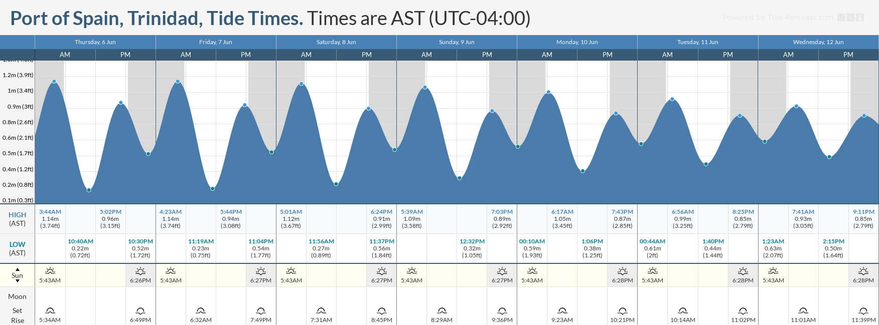
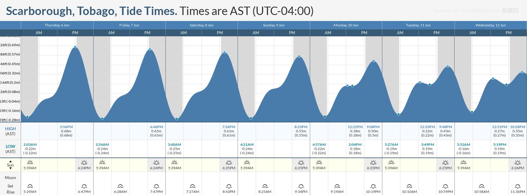
Spring tides, which are higher-than-usual high tides and lower-than-usual low tides, are forecast to end on Sunday, June 9th. Mariners and beachgoers will need to exercise caution at both low and high tide levels.
Additionally, with possible strong winds in the vicinity of heavy showers and thunderstorms, particularly from Sunday through Tuesday, small-craft operators will have to exercise extreme caution.
Rip currents always pose a hazard on the nation’s beaches. If caught in a rip current, swim perpendicular to the current (parallel to the shore). Mariners, especially small craft operators, should ensure their vessels are securely anchored or docked, as choppy/breaking wave conditions may drag the vessel onto the ocean floor or reefs in shallow waters or even break anchorage/mooring.


